Visualizing The Intervention - Mountain Division
Library
# Turn off scientific notation
options(scipen=999)

# Load packages
library(here)        # relative file paths for reproducibility
library(tidyverse)   # data wrangling
library(stringi)     # string data wrangling
library(tigris)      # US census TIGER/Line shapefiles
library(ggplot2)     # data visualization
library(cowplot)     # data visualization plotting
library(gridExtra)   # grid for data visualizations
library(biscale)     # bivariate mapping
library(kableExtra)  # table formatting
library(scales)      # palette and number formatting
library(cluster)     # clustering algorithms
library(factoextra)  # clustering algorithms & visualization
Functions
import::here( "fips_census_regions",
              "load_svi_data",
              "merge_svi_data",
              "census_division",
              "flag_summarize",
              "summarize_county_nmtc",
              "summarize_county_lihtc",
              "elbow_plot",
             # notice the use of here::here() that points to the .R file
             # where all these R objects are created
             .from = here::here("analysis/project_data_steps_knopp.R"),
             .character_only = TRUE)
SVI Data
# Load SVI data sets
svi_2010 <- readRDS(here::here("data/raw/Census_Data_SVI/svi_2010_trt10.rds"))
svi_2020 <- readRDS(here::here("data/raw/Census_Data_SVI/svi_2020_trt10.rds"))

# Load mapping data sets
svi_county_map2010 <- readRDS(here::here(paste0("data/wrangling/", str_replace_all(census_division, " ", "_"), "_county_svi_flags10.rds")))

svi_county_map2020 <- readRDS(here::here(paste0("data/wrangling/", str_replace_all(census_division, " ", "_"), "_county_svi_flags20.rds")))

divisional_st_sf <- readRDS(here::here(paste0("data/wrangling/", str_replace_all(census_division, " ", "_"), "_st_sf.rds")))
New Market Tax Credit (NMTC) & Low Income Housing Tax Credit (LIHTC) Data
# Load NMTC & LIHTC Tract Eligibility Data

orig_nmtc <- readxl::read_excel(here::here("data/raw/NMTC_LIHTC_tracts/nmtc_2011-2015_lic_110217.xlsx"), sheet="NMTC LICs 2011-2015 ACS")

high_migration_nmtc <- readxl::read_excel(here::here("data/raw/NMTC_LIHTC_tracts/nmtc_2011-2015_lic_110217.xlsx"), sheet="High migration tracts", skip=1)

nmtc_awards_data <- readxl::read_excel(here::here("data/raw/NMTC_LIHTC_tracts/NMTC_Public_Data_Release_includes_FY_2021_Data_final.xlsx"), sheet = "Projects 2 - Data Set PUBLISH.P")

lihtc_eligible <- readxl::read_excel(here::here("data/raw/NMTC_LIHTC_tracts/qct_data_2010_2011_2012.xlsx"))

lihtc_projects <- read.csv(here::here("data/raw/NMTC_LIHTC_tracts/lihtcpub/LIHTCPUB.csv"))
Load 2010 SVI Data
# National 2010 Data
svi_2010_national <- load_svi_data(svi_2010, percentile=.75)
svi_2010_national %>% head() %>% kbl() %>% kable_styling() %>% scroll_box(width = "100%")
| GEOID_2010_trt | FIPS_st | FIPS_county | FIPS_tract | state | state_name | county | region_number | region | division_number | division | E_TOTPOP_10 | E_HU_10 | E_HH_10 | E_POV150_10 | ET_POVSTATUS_10 | EP_POV150_10 | EPL_POV150_10 | F_POV150_10 | E_UNEMP_10 | ET_EMPSTATUS_10 | EP_UNEMP_10 | EPL_UNEMP_10 | F_UNEMP_10 | E_HBURD_OWN_10 | ET_HOUSINGCOST_OWN_10 | EP_HBURD_OWN_10 | EPL_HBURD_OWN_10 | F_HBURD_OWN_10 | E_HBURD_RENT_10 | ET_HOUSINGCOST_RENT_10 | EP_HBURD_RENT_10 | EPL_HBURD_RENT_10 | F_HBURD_RENT_10 | E_HBURD_10 | ET_HOUSINGCOST_10 | EP_HBURD_10 | EPL_HBURD_10 | F_HBURD_10 | E_NOHSDP_10 | ET_EDSTATUS_10 | EP_NOHSDP_10 | EPL_NOHSDP_10 | F_NOHSDP_10 | E_UNINSUR_12 | ET_INSURSTATUS_12 | EP_UNINSUR_12 | EPL_UNINSUR_12 | F_UNINSUR_12 | E_AGE65_10 | EP_AGE65_10 | EPL_AGE65_10 | F_AGE65_10 | E_AGE17_10 | EP_AGE17_10 | EPL_AGE17_10 | F_AGE17_10 | E_DISABL_12 | ET_DISABLSTATUS_12 | EP_DISABL_12 | EPL_DISABL_12 | F_DISABL_12 | E_SNGPNT_10 | ET_FAMILIES_10 | EP_SNGPNT_10 | EPL_SNGPNT_10 | F_SNGPNT_10 | E_LIMENG_10 | ET_POPAGE5UP_10 | EP_LIMENG_10 | EPL_LIMENG_10 | F_LIMENG_10 | E_MINRTY_10 | ET_POPETHRACE_10 | EP_MINRTY_10 | EPL_MINRTY_10 | F_MINRTY_10 | E_STRHU_10 | E_MUNIT_10 | EP_MUNIT_10 | EPL_MUNIT_10 | F_MUNIT_10 | E_MOBILE_10 | EP_MOBILE_10 | EPL_MOBILE_10 | F_MOBILE_10 | E_CROWD_10 | ET_OCCUPANTS_10 | EP_CROWD_10 | EPL_CROWD_10 | F_CROWD_10 | E_NOVEH_10 | ET_KNOWNVEH_10 | EP_NOVEH_10 | EPL_NOVEH_10 | F_NOVEH_10 | E_GROUPQ_10 | ET_HHTYPE_10 | EP_GROUPQ_10 | EPL_GROUPQ_10 | F_GROUPQ_10 | SPL_THEME1 | RPL_THEME1 | F_THEME1 | SPL_THEME2 | RPL_THEME2 | F_THEME2 | SPL_THEME3 | RPL_THEME3 | F_THEME3 | SPL_THEME4 | RPL_THEME4 | F_THEME4 | SPL_THEMES | RPL_THEMES | F_TOTAL |
|---|---|---|---|---|---|---|---|---|---|---|---|---|---|---|---|---|---|---|---|---|---|---|---|---|---|---|---|---|---|---|---|---|---|---|---|---|---|---|---|---|---|---|---|---|---|---|---|---|---|---|---|---|---|---|---|---|---|---|---|---|---|---|---|---|---|---|---|---|---|---|---|---|---|---|---|---|---|---|---|---|---|---|---|---|---|---|---|---|---|---|---|---|---|---|---|---|---|---|---|---|---|---|---|---|---|---|---|---|---|---|---|---|---|---|---|
| 01001020100 | 01 | 001 | 020100 | AL | Alabama | Autauga County | 3 | South Region | 6 | East South Central Division | 1809 | 771 | 696 | 297 | 1809 | 16.41791 | 0.3871 | 0 | 36 | 889 | 4.049494 | 0.1790 | 0 | 127 | 598 | 21.23746 | 0.20770 | 0 | 47 | 98 | 47.95918 | 0.5767 | 0 | 174 | 696 | 25.00000 | 0.18790 | 0 | 196 | 1242 | 15.780998 | 0.6093 | 0 | 186 | 1759 | 10.574190 | 0.3790 | 0 | 222 | 12.271973 | 0.4876 | 0 | 445 | 24.59923 | 0.5473 | 0 | 298 | 1335 | 22.32210 | 0.8454 | 1 | 27 | 545 | 4.954128 | 0.09275 | 0 | 36 | 1705 | 2.1114370 | 0.59040 | 0 | 385 | 1809 | 21.282477 | 0.4524 | 0 | 771 | 0 | 0.0000000 | 0.1224 | 0 | 92 | 11.9325551 | 0.8005 | 1 | 0 | 696 | 0.0000000 | 0.1238 | 0 | 50 | 696 | 7.183908 | 0.6134 | 0 | 0 | 1809 | 0 | 0.364 | 0 | 1.74230 | 0.28200 | 0 | 2.56345 | 0.5296 | 1 | 0.4524 | 0.4482 | 0 | 2.0241 | 0.2519 | 1 | 6.78225 | 0.3278 | 2 |
| 01001020200 | 01 | 001 | 020200 | AL | Alabama | Autauga County | 3 | South Region | 6 | East South Central Division | 2020 | 816 | 730 | 495 | 1992 | 24.84940 | 0.5954 | 0 | 68 | 834 | 8.153477 | 0.5754 | 0 | 49 | 439 | 11.16173 | 0.02067 | 0 | 105 | 291 | 36.08247 | 0.3019 | 0 | 154 | 730 | 21.09589 | 0.09312 | 0 | 339 | 1265 | 26.798419 | 0.8392 | 1 | 313 | 2012 | 15.556660 | 0.6000 | 0 | 204 | 10.099010 | 0.3419 | 0 | 597 | 29.55446 | 0.8192 | 1 | 359 | 1515 | 23.69637 | 0.8791 | 1 | 132 | 456 | 28.947368 | 0.83510 | 1 | 15 | 1890 | 0.7936508 | 0.40130 | 0 | 1243 | 2020 | 61.534653 | 0.7781 | 1 | 816 | 0 | 0.0000000 | 0.1224 | 0 | 34 | 4.1666667 | 0.6664 | 0 | 13 | 730 | 1.7808219 | 0.5406 | 0 | 115 | 730 | 15.753425 | 0.8382 | 1 | 0 | 2020 | 0 | 0.364 | 0 | 2.70312 | 0.56650 | 1 | 3.27660 | 0.8614 | 3 | 0.7781 | 0.7709 | 1 | 2.5316 | 0.5047 | 1 | 9.28942 | 0.6832 | 6 |
| 01001020300 | 01 | 001 | 020300 | AL | Alabama | Autauga County | 3 | South Region | 6 | East South Central Division | 3543 | 1403 | 1287 | 656 | 3533 | 18.56779 | 0.4443 | 0 | 93 | 1552 | 5.992268 | 0.3724 | 0 | 273 | 957 | 28.52665 | 0.45780 | 0 | 178 | 330 | 53.93939 | 0.7152 | 0 | 451 | 1287 | 35.04274 | 0.49930 | 0 | 346 | 2260 | 15.309734 | 0.5950 | 0 | 252 | 3102 | 8.123791 | 0.2596 | 0 | 487 | 13.745413 | 0.5868 | 0 | 998 | 28.16822 | 0.7606 | 1 | 371 | 2224 | 16.68165 | 0.6266 | 0 | 126 | 913 | 13.800657 | 0.46350 | 0 | 0 | 3365 | 0.0000000 | 0.09298 | 0 | 637 | 3543 | 17.979114 | 0.4049 | 0 | 1403 | 10 | 0.7127584 | 0.3015 | 0 | 2 | 0.1425517 | 0.4407 | 0 | 0 | 1287 | 0.0000000 | 0.1238 | 0 | 101 | 1287 | 7.847708 | 0.6443 | 0 | 0 | 3543 | 0 | 0.364 | 0 | 2.17060 | 0.41010 | 0 | 2.53048 | 0.5116 | 1 | 0.4049 | 0.4011 | 0 | 1.8743 | 0.1942 | 0 | 6.98028 | 0.3576 | 1 |
| 01001020400 | 01 | 001 | 020400 | AL | Alabama | Autauga County | 3 | South Region | 6 | East South Central Division | 4840 | 1957 | 1839 | 501 | 4840 | 10.35124 | 0.2177 | 0 | 101 | 2129 | 4.744011 | 0.2447 | 0 | 310 | 1549 | 20.01291 | 0.17080 | 0 | 89 | 290 | 30.68966 | 0.2044 | 0 | 399 | 1839 | 21.69657 | 0.10540 | 0 | 274 | 3280 | 8.353658 | 0.3205 | 0 | 399 | 4293 | 9.294200 | 0.3171 | 0 | 955 | 19.731405 | 0.8643 | 1 | 1195 | 24.69008 | 0.5530 | 0 | 625 | 3328 | 18.78005 | 0.7233 | 0 | 152 | 1374 | 11.062591 | 0.34710 | 0 | 10 | 4537 | 0.2204100 | 0.22560 | 0 | 297 | 4840 | 6.136364 | 0.1647 | 0 | 1957 | 33 | 1.6862545 | 0.3843 | 0 | 25 | 1.2774655 | 0.5516 | 0 | 14 | 1839 | 0.7612833 | 0.3564 | 0 | 19 | 1839 | 1.033170 | 0.1127 | 0 | 0 | 4840 | 0 | 0.364 | 0 | 1.20540 | 0.13470 | 0 | 2.71330 | 0.6129 | 1 | 0.1647 | 0.1632 | 0 | 1.7690 | 0.1591 | 0 | 5.85240 | 0.1954 | 1 |
| 01001020500 | 01 | 001 | 020500 | AL | Alabama | Autauga County | 3 | South Region | 6 | East South Central Division | 9938 | 3969 | 3741 | 1096 | 9938 | 11.02838 | 0.2364 | 0 | 188 | 4937 | 3.807981 | 0.1577 | 0 | 426 | 2406 | 17.70574 | 0.11050 | 0 | 528 | 1335 | 39.55056 | 0.3753 | 0 | 954 | 3741 | 25.50120 | 0.20140 | 0 | 293 | 5983 | 4.897209 | 0.1655 | 0 | 740 | 10110 | 7.319486 | 0.2211 | 0 | 837 | 8.422218 | 0.2408 | 0 | 3012 | 30.30791 | 0.8455 | 1 | 759 | 7155 | 10.60797 | 0.2668 | 0 | 476 | 2529 | 18.821669 | 0.63540 | 0 | 78 | 9297 | 0.8389803 | 0.41110 | 0 | 1970 | 9938 | 19.822902 | 0.4330 | 0 | 3969 | 306 | 7.7097506 | 0.6153 | 0 | 0 | 0.0000000 | 0.2198 | 0 | 7 | 3741 | 0.1871157 | 0.2535 | 0 | 223 | 3741 | 5.960973 | 0.5483 | 0 | 0 | 9938 | 0 | 0.364 | 0 | 0.98210 | 0.08468 | 0 | 2.39960 | 0.4381 | 1 | 0.4330 | 0.4290 | 0 | 2.0009 | 0.2430 | 0 | 5.81560 | 0.1905 | 1 |
| 01001020600 | 01 | 001 | 020600 | AL | Alabama | Autauga County | 3 | South Region | 6 | East South Central Division | 3402 | 1456 | 1308 | 735 | 3402 | 21.60494 | 0.5199 | 0 | 134 | 1720 | 7.790698 | 0.5436 | 0 | 242 | 1032 | 23.44961 | 0.28010 | 0 | 62 | 276 | 22.46377 | 0.1035 | 0 | 304 | 1308 | 23.24159 | 0.14070 | 0 | 301 | 2151 | 13.993491 | 0.5510 | 0 | 355 | 3445 | 10.304790 | 0.3656 | 0 | 386 | 11.346267 | 0.4232 | 0 | 931 | 27.36626 | 0.7200 | 0 | 440 | 2439 | 18.04018 | 0.6912 | 0 | 143 | 924 | 15.476190 | 0.52900 | 0 | 4 | 3254 | 0.1229256 | 0.19840 | 0 | 723 | 3402 | 21.252205 | 0.4519 | 0 | 1456 | 18 | 1.2362637 | 0.3507 | 0 | 433 | 29.7390110 | 0.9468 | 1 | 16 | 1308 | 1.2232416 | 0.4493 | 0 | 28 | 1308 | 2.140673 | 0.2298 | 0 | 0 | 3402 | 0 | 0.364 | 0 | 2.12080 | 0.39510 | 0 | 2.56180 | 0.5288 | 0 | 0.4519 | 0.4477 | 0 | 2.3406 | 0.4048 | 1 | 7.47510 | 0.4314 | 1 |
# Divisional 2010 Data
svi_2010_divisional <- load_svi_data(svi_2010, rank_by = "divisional", location = census_division, percentile=.75)
svi_2010_divisional %>% head() %>% kbl() %>% kable_styling() %>% scroll_box(width = "100%")
| GEOID_2010_trt | FIPS_st | FIPS_county | FIPS_tract | state | state_name | county | region_number | region | division_number | division | E_TOTPOP_10 | E_HU_10 | E_HH_10 | E_POV150_10 | ET_POVSTATUS_10 | EP_POV150_10 | EPL_POV150_10 | F_POV150_10 | E_UNEMP_10 | ET_EMPSTATUS_10 | EP_UNEMP_10 | EPL_UNEMP_10 | F_UNEMP_10 | E_HBURD_OWN_10 | ET_HOUSINGCOST_OWN_10 | EP_HBURD_OWN_10 | EPL_HBURD_OWN_10 | F_HBURD_OWN_10 | E_HBURD_RENT_10 | ET_HOUSINGCOST_RENT_10 | EP_HBURD_RENT_10 | EPL_HBURD_RENT_10 | F_HBURD_RENT_10 | E_HBURD_10 | ET_HOUSINGCOST_10 | EP_HBURD_10 | EPL_HBURD_10 | F_HBURD_10 | E_NOHSDP_10 | ET_EDSTATUS_10 | EP_NOHSDP_10 | EPL_NOHSDP_10 | F_NOHSDP_10 | E_UNINSUR_12 | ET_INSURSTATUS_12 | EP_UNINSUR_12 | EPL_UNINSUR_12 | F_UNINSUR_12 | E_AGE65_10 | EP_AGE65_10 | EPL_AGE65_10 | F_AGE65_10 | E_AGE17_10 | EP_AGE17_10 | EPL_AGE17_10 | F_AGE17_10 | E_DISABL_12 | ET_DISABLSTATUS_12 | EP_DISABL_12 | EPL_DISABL_12 | F_DISABL_12 | E_SNGPNT_10 | ET_FAMILIES_10 | EP_SNGPNT_10 | EPL_SNGPNT_10 | F_SNGPNT_10 | E_LIMENG_10 | ET_POPAGE5UP_10 | EP_LIMENG_10 | EPL_LIMENG_10 | F_LIMENG_10 | E_MINRTY_10 | ET_POPETHRACE_10 | EP_MINRTY_10 | EPL_MINRTY_10 | F_MINRTY_10 | E_STRHU_10 | E_MUNIT_10 | EP_MUNIT_10 | EPL_MUNIT_10 | F_MUNIT_10 | E_MOBILE_10 | EP_MOBILE_10 | EPL_MOBILE_10 | F_MOBILE_10 | E_CROWD_10 | ET_OCCUPANTS_10 | EP_CROWD_10 | EPL_CROWD_10 | F_CROWD_10 | E_NOVEH_10 | ET_KNOWNVEH_10 | EP_NOVEH_10 | EPL_NOVEH_10 | F_NOVEH_10 | E_GROUPQ_10 | ET_HHTYPE_10 | EP_GROUPQ_10 | EPL_GROUPQ_10 | F_GROUPQ_10 | SPL_THEME1 | RPL_THEME1 | F_THEME1 | SPL_THEME2 | RPL_THEME2 | F_THEME2 | SPL_THEME3 | RPL_THEME3 | F_THEME3 | SPL_THEME4 | RPL_THEME4 | F_THEME4 | SPL_THEMES | RPL_THEMES | F_TOTAL |
|---|---|---|---|---|---|---|---|---|---|---|---|---|---|---|---|---|---|---|---|---|---|---|---|---|---|---|---|---|---|---|---|---|---|---|---|---|---|---|---|---|---|---|---|---|---|---|---|---|---|---|---|---|---|---|---|---|---|---|---|---|---|---|---|---|---|---|---|---|---|---|---|---|---|---|---|---|---|---|---|---|---|---|---|---|---|---|---|---|---|---|---|---|---|---|---|---|---|---|---|---|---|---|---|---|---|---|---|---|---|---|---|---|---|---|---|
| 04001942600 | 04 | 001 | 942600 | AZ | Arizona | Apache County | 4 | West Region | 8 | Mountain Division | 1561 | 762 | 384 | 1150 | 1561 | 73.67072 | 0.9944 | 1 | 26 | 300 | 8.666667 | 0.6866 | 0 | 65 | 366 | 17.759563 | 0.10180 | 0 | 5 | 18 | 27.77778 | 0.19090 | 0 | 70 | 384 | 18.22917 | 0.05781 | 0 | 303 | 839 | 36.11442 | 0.9335 | 1 | 282 | 1578 | 17.87072 | 0.5921 | 0 | 153 | 9.801409 | 0.4496 | 0 | 560 | 35.87444 | 0.9044 | 1 | 240 | 1054 | 22.770398 | 0.9006 | 1 | 107 | 332 | 32.22892 | 0.9163 | 1 | 168 | 1431 | 11.740042 | 0.8831 | 1 | 1561 | 1561 | 100.00000 | 0.9989 | 1 | 762 | 0 | 0.0000000 | 0.1526 | 0 | 215 | 28.21522 | 0.9088 | 1 | 117 | 384 | 30.46875 | 0.9979 | 1 | 33 | 384 | 8.59375 | 0.7842 | 1 | 0 | 1561 | 0.000000 | 0.3955 | 0 | 3.26441 | 0.7248 | 2 | 4.0540 | 0.9853 | 4 | 0.9989 | 0.9931 | 1 | 3.2390 | 0.8004 | 3 | 11.55631 | 0.8966 | 10 |
| 04001942700 | 04 | 001 | 942700 | AZ | Arizona | Apache County | 4 | West Region | 8 | Mountain Division | 4886 | 2757 | 1291 | 2616 | 4871 | 53.70560 | 0.9480 | 1 | 163 | 1398 | 11.659514 | 0.8577 | 1 | 102 | 1113 | 9.164421 | 0.01757 | 0 | 54 | 178 | 30.33708 | 0.22790 | 0 | 156 | 1291 | 12.08366 | 0.01652 | 0 | 1039 | 2931 | 35.44865 | 0.9303 | 1 | 1873 | 5249 | 35.68299 | 0.9436 | 1 | 688 | 14.081048 | 0.6870 | 0 | 1530 | 31.31396 | 0.7718 | 1 | 772 | 3514 | 21.969266 | 0.8839 | 1 | 246 | 939 | 26.19808 | 0.8308 | 1 | 592 | 4631 | 12.783416 | 0.8975 | 1 | 4846 | 4886 | 99.18133 | 0.9946 | 1 | 2757 | 0 | 0.0000000 | 0.1526 | 0 | 369 | 13.38411 | 0.7652 | 1 | 240 | 1291 | 18.59024 | 0.9756 | 1 | 188 | 1291 | 14.56235 | 0.9015 | 1 | 0 | 4886 | 0.000000 | 0.3955 | 0 | 3.69612 | 0.8288 | 4 | 4.0710 | 0.9870 | 4 | 0.9946 | 0.9890 | 1 | 3.1904 | 0.7848 | 3 | 11.95212 | 0.9295 | 12 |
| 04001944000 | 04 | 001 | 944000 | AZ | Arizona | Apache County | 4 | West Region | 8 | Mountain Division | 5958 | 2178 | 1275 | 3112 | 5958 | 52.23229 | 0.9399 | 1 | 107 | 1895 | 5.646438 | 0.4130 | 0 | 108 | 880 | 12.272727 | 0.03476 | 0 | 112 | 395 | 28.35443 | 0.19940 | 0 | 220 | 1275 | 17.25490 | 0.04955 | 0 | 1030 | 3376 | 30.50948 | 0.9015 | 1 | 2632 | 5821 | 45.21560 | 0.9873 | 1 | 472 | 7.922122 | 0.3301 | 0 | 1792 | 30.07721 | 0.7211 | 0 | 299 | 4027 | 7.424882 | 0.1343 | 0 | 272 | 979 | 27.78345 | 0.8590 | 1 | 153 | 5325 | 2.873239 | 0.6096 | 0 | 5846 | 5958 | 98.12017 | 0.9893 | 1 | 2178 | 0 | 0.0000000 | 0.1526 | 0 | 448 | 20.56933 | 0.8562 | 1 | 247 | 1275 | 19.37255 | 0.9798 | 1 | 135 | 1275 | 10.58824 | 0.8373 | 1 | 0 | 5958 | 0.000000 | 0.3955 | 0 | 3.29125 | 0.7314 | 3 | 2.6541 | 0.5792 | 1 | 0.9893 | 0.9836 | 1 | 3.2214 | 0.7946 | 3 | 10.15605 | 0.7714 | 8 |
| 04001944100 | 04 | 001 | 944100 | AZ | Arizona | Apache County | 4 | West Region | 8 | Mountain Division | 4975 | 2485 | 1204 | 3251 | 4968 | 65.43881 | 0.9846 | 1 | 210 | 1254 | 16.746412 | 0.9576 | 1 | 122 | 905 | 13.480663 | 0.04383 | 0 | 91 | 299 | 30.43478 | 0.22960 | 0 | 213 | 1204 | 17.69103 | 0.05320 | 0 | 779 | 2325 | 33.50538 | 0.9203 | 1 | 1293 | 5511 | 23.46217 | 0.7705 | 1 | 344 | 6.914573 | 0.2701 | 0 | 1993 | 40.06030 | 0.9701 | 1 | 577 | 3087 | 18.691286 | 0.7799 | 1 | 278 | 893 | 31.13102 | 0.9038 | 1 | 308 | 4470 | 6.890380 | 0.7895 | 1 | 4915 | 4975 | 98.79397 | 0.9929 | 1 | 2485 | 21 | 0.8450704 | 0.3700 | 0 | 428 | 17.22334 | 0.8203 | 1 | 257 | 1204 | 21.34551 | 0.9843 | 1 | 212 | 1204 | 17.60797 | 0.9391 | 1 | 0 | 4975 | 0.000000 | 0.3955 | 0 | 3.68620 | 0.8261 | 4 | 3.7134 | 0.9528 | 4 | 0.9929 | 0.9872 | 1 | 3.5092 | 0.8926 | 3 | 11.90170 | 0.9244 | 12 |
| 04001944201 | 04 | 001 | 944201 | AZ | Arizona | Apache County | 4 | West Region | 8 | Mountain Division | 3751 | 1392 | 984 | 2202 | 3689 | 59.69097 | 0.9743 | 1 | 242 | 1082 | 22.365989 | 0.9848 | 1 | 99 | 409 | 24.205379 | 0.27880 | 0 | 92 | 575 | 16.00000 | 0.07805 | 0 | 191 | 984 | 19.41057 | 0.07144 | 0 | 566 | 2008 | 28.18725 | 0.8822 | 1 | 1055 | 3994 | 26.41462 | 0.8304 | 1 | 172 | 4.585444 | 0.1308 | 0 | 1420 | 37.85657 | 0.9429 | 1 | 229 | 2320 | 9.870690 | 0.2738 | 0 | 187 | 722 | 25.90028 | 0.8248 | 1 | 200 | 3509 | 5.699630 | 0.7542 | 1 | 3521 | 3751 | 93.86830 | 0.9778 | 1 | 1392 | 19 | 1.3649425 | 0.4136 | 0 | 284 | 20.40230 | 0.8539 | 1 | 114 | 984 | 11.58537 | 0.9345 | 1 | 121 | 984 | 12.29675 | 0.8677 | 1 | 266 | 3751 | 7.091442 | 0.9297 | 1 | 3.74314 | 0.8389 | 4 | 2.9265 | 0.7044 | 3 | 0.9778 | 0.9722 | 1 | 3.9994 | 0.9770 | 4 | 11.64684 | 0.9044 | 12 |
| 04001944202 | 04 | 001 | 944202 | AZ | Arizona | Apache County | 4 | West Region | 8 | Mountain Division | 3330 | 1463 | 897 | 1814 | 3330 | 54.47447 | 0.9514 | 1 | 345 | 1024 | 33.691406 | 0.9983 | 1 | 58 | 745 | 7.785235 | 0.01352 | 0 | 38 | 152 | 25.00000 | 0.15680 | 0 | 96 | 897 | 10.70234 | 0.01191 | 0 | 742 | 2041 | 36.35473 | 0.9351 | 1 | 1201 | 3754 | 31.99254 | 0.9089 | 1 | 366 | 10.990991 | 0.5201 | 0 | 873 | 26.21622 | 0.5389 | 0 | 573 | 2986 | 19.189551 | 0.8002 | 1 | 151 | 550 | 27.45455 | 0.8540 | 1 | 173 | 3057 | 5.659143 | 0.7527 | 1 | 3306 | 3330 | 99.27928 | 0.9948 | 1 | 1463 | 0 | 0.0000000 | 0.1526 | 0 | 355 | 24.26521 | 0.8840 | 1 | 114 | 897 | 12.70903 | 0.9435 | 1 | 257 | 897 | 28.65106 | 0.9864 | 1 | 93 | 3330 | 2.792793 | 0.8680 | 1 | 3.80561 | 0.8512 | 4 | 3.4659 | 0.8981 | 3 | 0.9948 | 0.9891 | 1 | 3.8345 | 0.9589 | 4 | 12.10081 | 0.9410 | 12 |
Load 2020 Data
# National 2020 Data
svi_2020_national <- load_svi_data(svi_2020, percentile=.75)
svi_2020_national %>% head() %>% kbl() %>% kable_styling() %>% scroll_box(width = "100%")
| GEOID_2010_trt | FIPS_st | FIPS_county | FIPS_tract | state | state_name | county | region_number | region | division_number | division | E_TOTPOP_20 | E_HU_20 | E_HH_20 | E_POV150_20 | ET_POVSTATUS_20 | EP_POV150_20 | EPL_POV150_20 | F_POV150_20 | E_UNEMP_20 | ET_EMPSTATUS_20 | EP_UNEMP_20 | EPL_UNEMP_20 | F_UNEMP_20 | E_HBURD_OWN_20 | ET_HOUSINGCOST_OWN_20 | EP_HBURD_OWN_20 | EPL_HBURD_OWN_20 | F_HBURD_OWN_20 | E_HBURD_RENT_20 | ET_HOUSINGCOST_RENT_20 | EP_HBURD_RENT_20 | EPL_HBURD_RENT_20 | F_HBURD_RENT_20 | E_HBURD_20 | ET_HOUSINGCOST_20 | EP_HBURD_20 | EPL_HBURD_20 | F_HBURD_20 | E_NOHSDP_20 | ET_EDSTATUS_20 | EP_NOHSDP_20 | EPL_NOHSDP_20 | F_NOHSDP_20 | E_UNINSUR_20 | ET_INSURSTATUS_20 | EP_UNINSUR_20 | EPL_UNINSUR_20 | F_UNINSUR_20 | E_AGE65_20 | EP_AGE65_20 | EPL_AGE65_20 | F_AGE65_20 | E_AGE17_20 | EP_AGE17_20 | EPL_AGE17_20 | F_AGE17_20 | E_DISABL_20 | ET_DISABLSTATUS_20 | EP_DISABL_20 | EPL_DISABL_20 | F_DISABL_20 | E_SNGPNT_20 | ET_FAMILIES_20 | EP_SNGPNT_20 | EPL_SNGPNT_20 | F_SNGPNT_20 | E_LIMENG_20 | ET_POPAGE5UP_20 | EP_LIMENG_20 | EPL_LIMENG_20 | F_LIMENG_20 | E_MINRTY_20 | ET_POPETHRACE_20 | EP_MINRTY_20 | EPL_MINRTY_20 | F_MINRTY_20 | E_STRHU_20 | E_MUNIT_20 | EP_MUNIT_20 | EPL_MUNIT_20 | F_MUNIT_20 | E_MOBILE_20 | EP_MOBILE_20 | EPL_MOBILE_20 | F_MOBILE_20 | E_CROWD_20 | ET_OCCUPANTS_20 | EP_CROWD_20 | EPL_CROWD_20 | F_CROWD_20 | E_NOVEH_20 | ET_KNOWNVEH_20 | EP_NOVEH_20 | EPL_NOVEH_20 | F_NOVEH_20 | E_GROUPQ_20 | ET_HHTYPE_20 | EP_GROUPQ_20 | EPL_GROUPQ_20 | F_GROUPQ_20 | SPL_THEME1 | RPL_THEME1 | F_THEME1 | SPL_THEME2 | RPL_THEME2 | F_THEME2 | SPL_THEME3 | RPL_THEME3 | F_THEME3 | SPL_THEME4 | RPL_THEME4 | F_THEME4 | SPL_THEMES | RPL_THEMES | F_TOTAL |
|---|---|---|---|---|---|---|---|---|---|---|---|---|---|---|---|---|---|---|---|---|---|---|---|---|---|---|---|---|---|---|---|---|---|---|---|---|---|---|---|---|---|---|---|---|---|---|---|---|---|---|---|---|---|---|---|---|---|---|---|---|---|---|---|---|---|---|---|---|---|---|---|---|---|---|---|---|---|---|---|---|---|---|---|---|---|---|---|---|---|---|---|---|---|---|---|---|---|---|---|---|---|---|---|---|---|---|---|---|---|---|---|---|---|---|---|
| 01001020100 | 01 | 001 | 020100 | AL | Alabama | Autauga County | 3 | South Region | 6 | East South Central Division | 1941 | 710 | 693 | 352 | 1941 | 18.13498 | 0.4630 | 0 | 18 | 852 | 2.112676 | 0.15070 | 0 | 81 | 507 | 15.976331 | 0.26320 | 0 | 63 | 186 | 33.87097 | 0.2913 | 0 | 144 | 693 | 20.77922 | 0.2230 | 0 | 187 | 1309 | 14.285714 | 0.6928 | 0 | 187 | 1941 | 9.634209 | 0.6617 | 0 | 295 | 15.19835 | 0.4601 | 0 | 415 | 21.38073 | 0.4681 | 0 | 391 | 1526 | 25.62254 | 0.9011 | 1 | 58 | 555 | 10.45045 | 0.3451 | 0 | 0 | 1843 | 0.0000000 | 0.09479 | 0 | 437 | 1941 | 22.51417 | 0.3902 | 0 | 710 | 0 | 0.0000000 | 0.1079 | 0 | 88 | 12.3943662 | 0.8263 | 1 | 0 | 693 | 0.0000000 | 0.09796 | 0 | 10 | 693 | 1.443001 | 0.1643 | 0 | 0 | 1941 | 0.000000 | 0.1831 | 0 | 2.19120 | 0.4084 | 0 | 2.26919 | 0.3503 | 1 | 0.3902 | 0.3869 | 0 | 1.37956 | 0.07216 | 1 | 6.23015 | 0.2314 | 2 |
| 01001020200 | 01 | 001 | 020200 | AL | Alabama | Autauga County | 3 | South Region | 6 | East South Central Division | 1757 | 720 | 573 | 384 | 1511 | 25.41363 | 0.6427 | 0 | 29 | 717 | 4.044630 | 0.41320 | 0 | 33 | 392 | 8.418367 | 0.03542 | 0 | 116 | 181 | 64.08840 | 0.9086 | 1 | 149 | 573 | 26.00349 | 0.4041 | 0 | 139 | 1313 | 10.586443 | 0.5601 | 0 | 91 | 1533 | 5.936073 | 0.4343 | 0 | 284 | 16.16392 | 0.5169 | 0 | 325 | 18.49744 | 0.2851 | 0 | 164 | 1208 | 13.57616 | 0.4127 | 0 | 42 | 359 | 11.69916 | 0.3998 | 0 | 0 | 1651 | 0.0000000 | 0.09479 | 0 | 1116 | 1757 | 63.51736 | 0.7591 | 1 | 720 | 3 | 0.4166667 | 0.2470 | 0 | 5 | 0.6944444 | 0.5106 | 0 | 9 | 573 | 1.5706806 | 0.46880 | 0 | 57 | 573 | 9.947644 | 0.7317 | 0 | 212 | 1757 | 12.066022 | 0.9549 | 1 | 2.45440 | 0.4888 | 0 | 1.70929 | 0.1025 | 0 | 0.7591 | 0.7527 | 1 | 2.91300 | 0.68620 | 1 | 7.83579 | 0.4802 | 2 |
| 01001020300 | 01 | 001 | 020300 | AL | Alabama | Autauga County | 3 | South Region | 6 | East South Central Division | 3694 | 1464 | 1351 | 842 | 3694 | 22.79372 | 0.5833 | 0 | 53 | 1994 | 2.657974 | 0.22050 | 0 | 117 | 967 | 12.099276 | 0.11370 | 0 | 147 | 384 | 38.28125 | 0.3856 | 0 | 264 | 1351 | 19.54108 | 0.1827 | 0 | 317 | 2477 | 12.797739 | 0.6460 | 0 | 127 | 3673 | 3.457664 | 0.2308 | 0 | 464 | 12.56091 | 0.3088 | 0 | 929 | 25.14889 | 0.7080 | 0 | 473 | 2744 | 17.23761 | 0.6211 | 0 | 263 | 975 | 26.97436 | 0.8234 | 1 | 128 | 3586 | 3.5694367 | 0.70770 | 0 | 1331 | 3694 | 36.03140 | 0.5515 | 0 | 1464 | 26 | 1.7759563 | 0.3675 | 0 | 14 | 0.9562842 | 0.5389 | 0 | 35 | 1351 | 2.5906736 | 0.60550 | 0 | 42 | 1351 | 3.108808 | 0.3415 | 0 | 0 | 3694 | 0.000000 | 0.1831 | 0 | 1.86330 | 0.3063 | 0 | 3.16900 | 0.8380 | 1 | 0.5515 | 0.5468 | 0 | 2.03650 | 0.26830 | 0 | 7.62030 | 0.4460 | 1 |
| 01001020400 | 01 | 001 | 020400 | AL | Alabama | Autauga County | 3 | South Region | 6 | East South Central Division | 3539 | 1741 | 1636 | 503 | 3539 | 14.21305 | 0.3472 | 0 | 39 | 1658 | 2.352232 | 0.17990 | 0 | 219 | 1290 | 16.976744 | 0.30880 | 0 | 74 | 346 | 21.38728 | 0.1037 | 0 | 293 | 1636 | 17.90954 | 0.1333 | 0 | 173 | 2775 | 6.234234 | 0.3351 | 0 | 169 | 3529 | 4.788892 | 0.3448 | 0 | 969 | 27.38062 | 0.9225 | 1 | 510 | 14.41085 | 0.1208 | 0 | 670 | 3019 | 22.19278 | 0.8194 | 1 | 148 | 1137 | 13.01671 | 0.4541 | 0 | 89 | 3409 | 2.6107363 | 0.64690 | 0 | 454 | 3539 | 12.82848 | 0.2364 | 0 | 1741 | 143 | 8.2136703 | 0.6028 | 0 | 0 | 0.0000000 | 0.2186 | 0 | 10 | 1636 | 0.6112469 | 0.28340 | 0 | 72 | 1636 | 4.400978 | 0.4538 | 0 | 0 | 3539 | 0.000000 | 0.1831 | 0 | 1.34030 | 0.1575 | 0 | 2.96370 | 0.7496 | 2 | 0.2364 | 0.2344 | 0 | 1.74170 | 0.16270 | 0 | 6.28210 | 0.2389 | 2 |
| 01001020500 | 01 | 001 | 020500 | AL | Alabama | Autauga County | 3 | South Region | 6 | East South Central Division | 10674 | 4504 | 4424 | 1626 | 10509 | 15.47245 | 0.3851 | 0 | 81 | 5048 | 1.604596 | 0.09431 | 0 | 321 | 2299 | 13.962592 | 0.17970 | 0 | 711 | 2125 | 33.45882 | 0.2836 | 0 | 1032 | 4424 | 23.32731 | 0.3109 | 0 | 531 | 6816 | 7.790493 | 0.4251 | 0 | 301 | 10046 | 2.996217 | 0.1894 | 0 | 1613 | 15.11149 | 0.4553 | 0 | 2765 | 25.90407 | 0.7494 | 0 | 1124 | 7281 | 15.43744 | 0.5253 | 0 | 342 | 2912 | 11.74451 | 0.4019 | 0 | 52 | 9920 | 0.5241935 | 0.35230 | 0 | 2603 | 10674 | 24.38636 | 0.4160 | 0 | 4504 | 703 | 15.6083481 | 0.7378 | 0 | 29 | 0.6438721 | 0.5037 | 0 | 37 | 4424 | 0.8363472 | 0.33420 | 0 | 207 | 4424 | 4.679023 | 0.4754 | 0 | 176 | 10674 | 1.648866 | 0.7598 | 1 | 1.40481 | 0.1743 | 0 | 2.48420 | 0.4802 | 0 | 0.4160 | 0.4125 | 0 | 2.81090 | 0.63730 | 1 | 7.11591 | 0.3654 | 1 |
| 01001020600 | 01 | 001 | 020600 | AL | Alabama | Autauga County | 3 | South Region | 6 | East South Central Division | 3536 | 1464 | 1330 | 1279 | 3523 | 36.30429 | 0.8215 | 1 | 34 | 1223 | 2.780049 | 0.23780 | 0 | 321 | 1111 | 28.892889 | 0.75870 | 1 | 67 | 219 | 30.59361 | 0.2305 | 0 | 388 | 1330 | 29.17293 | 0.5075 | 0 | 306 | 2380 | 12.857143 | 0.6480 | 0 | 415 | 3496 | 11.870709 | 0.7535 | 1 | 547 | 15.46946 | 0.4760 | 0 | 982 | 27.77149 | 0.8327 | 1 | 729 | 2514 | 28.99761 | 0.9488 | 1 | 95 | 880 | 10.79545 | 0.3601 | 0 | 0 | 3394 | 0.0000000 | 0.09479 | 0 | 985 | 3536 | 27.85633 | 0.4608 | 0 | 1464 | 0 | 0.0000000 | 0.1079 | 0 | 364 | 24.8633880 | 0.9300 | 1 | 0 | 1330 | 0.0000000 | 0.09796 | 0 | 17 | 1330 | 1.278196 | 0.1463 | 0 | 0 | 3536 | 0.000000 | 0.1831 | 0 | 2.96830 | 0.6434 | 2 | 2.71239 | 0.6156 | 2 | 0.4608 | 0.4569 | 0 | 1.46526 | 0.08976 | 1 | 7.60675 | 0.4440 | 5 |
# Divisional 2020 Data
svi_2020_divisional <- load_svi_data(svi_2020, rank_by = "divisional", location =  census_division, percentile=.75)
svi_2020_divisional %>% head() %>% kbl() %>% kable_styling() %>% scroll_box(width = "100%")
| GEOID_2010_trt | FIPS_st | FIPS_county | FIPS_tract | state | state_name | county | region_number | region | division_number | division | E_TOTPOP_20 | E_HU_20 | E_HH_20 | E_POV150_20 | ET_POVSTATUS_20 | EP_POV150_20 | EPL_POV150_20 | F_POV150_20 | E_UNEMP_20 | ET_EMPSTATUS_20 | EP_UNEMP_20 | EPL_UNEMP_20 | F_UNEMP_20 | E_HBURD_OWN_20 | ET_HOUSINGCOST_OWN_20 | EP_HBURD_OWN_20 | EPL_HBURD_OWN_20 | F_HBURD_OWN_20 | E_HBURD_RENT_20 | ET_HOUSINGCOST_RENT_20 | EP_HBURD_RENT_20 | EPL_HBURD_RENT_20 | F_HBURD_RENT_20 | E_HBURD_20 | ET_HOUSINGCOST_20 | EP_HBURD_20 | EPL_HBURD_20 | F_HBURD_20 | E_NOHSDP_20 | ET_EDSTATUS_20 | EP_NOHSDP_20 | EPL_NOHSDP_20 | F_NOHSDP_20 | E_UNINSUR_20 | ET_INSURSTATUS_20 | EP_UNINSUR_20 | EPL_UNINSUR_20 | F_UNINSUR_20 | E_AGE65_20 | EP_AGE65_20 | EPL_AGE65_20 | F_AGE65_20 | E_AGE17_20 | EP_AGE17_20 | EPL_AGE17_20 | F_AGE17_20 | E_DISABL_20 | ET_DISABLSTATUS_20 | EP_DISABL_20 | EPL_DISABL_20 | F_DISABL_20 | E_SNGPNT_20 | ET_FAMILIES_20 | EP_SNGPNT_20 | EPL_SNGPNT_20 | F_SNGPNT_20 | E_LIMENG_20 | ET_POPAGE5UP_20 | EP_LIMENG_20 | EPL_LIMENG_20 | F_LIMENG_20 | E_MINRTY_20 | ET_POPETHRACE_20 | EP_MINRTY_20 | EPL_MINRTY_20 | F_MINRTY_20 | E_STRHU_20 | E_MUNIT_20 | EP_MUNIT_20 | EPL_MUNIT_20 | F_MUNIT_20 | E_MOBILE_20 | EP_MOBILE_20 | EPL_MOBILE_20 | F_MOBILE_20 | E_CROWD_20 | ET_OCCUPANTS_20 | EP_CROWD_20 | EPL_CROWD_20 | F_CROWD_20 | E_NOVEH_20 | ET_KNOWNVEH_20 | EP_NOVEH_20 | EPL_NOVEH_20 | F_NOVEH_20 | E_GROUPQ_20 | ET_HHTYPE_20 | EP_GROUPQ_20 | EPL_GROUPQ_20 | F_GROUPQ_20 | SPL_THEME1 | RPL_THEME1 | F_THEME1 | SPL_THEME2 | RPL_THEME2 | F_THEME2 | SPL_THEME3 | RPL_THEME3 | F_THEME3 | SPL_THEME4 | RPL_THEME4 | F_THEME4 | SPL_THEMES | RPL_THEMES | F_TOTAL |
|---|---|---|---|---|---|---|---|---|---|---|---|---|---|---|---|---|---|---|---|---|---|---|---|---|---|---|---|---|---|---|---|---|---|---|---|---|---|---|---|---|---|---|---|---|---|---|---|---|---|---|---|---|---|---|---|---|---|---|---|---|---|---|---|---|---|---|---|---|---|---|---|---|---|---|---|---|---|---|---|---|---|---|---|---|---|---|---|---|---|---|---|---|---|---|---|---|---|---|---|---|---|---|---|---|---|---|---|---|---|---|---|---|---|---|---|
| 04001942600 | 04 | 001 | 942600 | AZ | Arizona | Apache County | 4 | West Region | 8 | Mountain Division | 1711 | 676 | 469 | 930 | 1711 | 54.35418 | 0.9708 | 1 | 44 | 484 | 9.090909 | 0.8539 | 1 | 32 | 456 | 7.017544 | 0.02013 | 0 | 4 | 13 | 30.76923 | 0.24630 | 0 | 36 | 469 | 7.675906 | 0.005758 | 0 | 304 | 1197 | 25.39683 | 0.9056 | 1 | 686 | 1711 | 40.09351 | 0.9973 | 1 | 229 | 13.38399 | 0.4397 | 0 | 347 | 20.28054 | 0.3788 | 0 | 245 | 1363.979 | 17.962156 | 0.68240 | 0 | 49 | 304.000 | 16.11842 | 0.5859 | 0 | 155 | 1652 | 9.382567 | 0.8951 | 1 | 1711 | 1710.980 | 100.00115 | 1.0000 | 1 | 676 | 0 | 0.0000000 | 0.1276 | 0 | 142 | 21.00592 | 0.8736 | 1 | 83 | 469 | 17.697228 | 0.9774 | 1 | 99 | 469.000 | 21.108742 | 0.9655 | 1 | 0 | 1711 | 0.0000000 | 0.2155 | 0 | 3.733358 | 0.8474 | 4 | 2.98190 | 0.7375 | 1 | 1.0000 | 0.9958 | 1 | 3.1596 | 0.7653 | 3 | 10.87486 | 0.8573 | 9 |
| 04001942700 | 04 | 001 | 942700 | AZ | Arizona | Apache County | 4 | West Region | 8 | Mountain Division | 5469 | 2222 | 1462 | 2784 | 5469 | 50.90510 | 0.9557 | 1 | 358 | 1642 | 21.802680 | 0.9925 | 1 | 114 | 1151 | 9.904431 | 0.04797 | 0 | 58 | 311 | 18.64952 | 0.09477 | 0 | 172 | 1462 | 11.764706 | 0.023990 | 0 | 852 | 3274 | 26.02321 | 0.9120 | 1 | 1856 | 5466 | 33.95536 | 0.9919 | 1 | 759 | 13.87822 | 0.4657 | 0 | 1555 | 28.43299 | 0.7739 | 1 | 706 | 3911.002 | 18.051640 | 0.68720 | 0 | 257 | 1035.000 | 24.83091 | 0.8039 | 1 | 396 | 5078 | 7.798346 | 0.8624 | 1 | 5420 | 5469.002 | 99.10401 | 0.9946 | 1 | 2222 | 0 | 0.0000000 | 0.1276 | 0 | 400 | 18.00180 | 0.8488 | 1 | 238 | 1462 | 16.279070 | 0.9710 | 1 | 175 | 1462.001 | 11.969898 | 0.8742 | 1 | 26 | 5469 | 0.4754068 | 0.6430 | 0 | 3.876090 | 0.8796 | 4 | 3.59310 | 0.9421 | 3 | 0.9946 | 0.9905 | 1 | 3.4646 | 0.8721 | 3 | 11.92839 | 0.9425 | 11 |
| 04001944000 | 04 | 001 | 944000 | AZ | Arizona | Apache County | 4 | West Region | 8 | Mountain Division | 6583 | 2464 | 1836 | 3270 | 6580 | 49.69605 | 0.9486 | 1 | 191 | 2029 | 9.413504 | 0.8663 | 1 | 89 | 1272 | 6.996855 | 0.01965 | 0 | 103 | 564 | 18.26241 | 0.09073 | 0 | 192 | 1836 | 10.457516 | 0.015550 | 0 | 753 | 4321 | 17.42652 | 0.8100 | 1 | 2993 | 6580 | 45.48632 | 0.9992 | 1 | 1034 | 15.70712 | 0.5561 | 0 | 1569 | 23.83412 | 0.5584 | 0 | 1069 | 5014.189 | 21.319499 | 0.81410 | 1 | 304 | 1237.278 | 24.57006 | 0.7989 | 1 | 141 | 6193 | 2.276764 | 0.6147 | 0 | 6436 | 6583.375 | 97.76141 | 0.9876 | 1 | 2464 | 20 | 0.8116883 | 0.3404 | 0 | 536 | 21.75325 | 0.8793 | 1 | 274 | 1836 | 14.923747 | 0.9643 | 1 | 326 | 1836.376 | 17.752353 | 0.9488 | 1 | 3 | 6583 | 0.0455719 | 0.4382 | 0 | 3.639650 | 0.8211 | 4 | 3.34220 | 0.8770 | 2 | 0.9876 | 0.9834 | 1 | 3.5710 | 0.9020 | 3 | 11.54045 | 0.9156 | 10 |
| 04001944100 | 04 | 001 | 944100 | AZ | Arizona | Apache County | 4 | West Region | 8 | Mountain Division | 6183 | 2379 | 1424 | 3704 | 5789 | 63.98342 | 0.9912 | 1 | 425 | 1608 | 26.430348 | 0.9954 | 1 | 132 | 1163 | 11.349957 | 0.07802 | 0 | 38 | 261 | 14.55939 | 0.06498 | 0 | 170 | 1424 | 11.938202 | 0.026300 | 0 | 862 | 3259 | 26.44983 | 0.9148 | 1 | 1320 | 6183 | 21.34886 | 0.9283 | 1 | 637 | 10.30244 | 0.2718 | 0 | 1869 | 30.22804 | 0.8396 | 1 | 626 | 3964.000 | 15.792129 | 0.57150 | 0 | 371 | 991.000 | 37.43693 | 0.9557 | 1 | 315 | 5717 | 5.509883 | 0.8021 | 1 | 5981 | 6182.998 | 96.73300 | 0.9841 | 1 | 2379 | 0 | 0.0000000 | 0.1276 | 0 | 442 | 18.57924 | 0.8550 | 1 | 379 | 1424 | 26.615168 | 0.9969 | 1 | 347 | 1424.000 | 24.367977 | 0.9758 | 1 | 394 | 6183 | 6.3723112 | 0.9380 | 1 | 3.856000 | 0.8749 | 4 | 3.44070 | 0.9070 | 3 | 0.9841 | 0.9800 | 1 | 3.8933 | 0.9609 | 4 | 12.17410 | 0.9549 | 12 |
| 04001944201 | 04 | 001 | 944201 | AZ | Arizona | Apache County | 4 | West Region | 8 | Mountain Division | 4540 | 1421 | 1193 | 3069 | 4456 | 68.87343 | 0.9946 | 1 | 53 | 702 | 7.549857 | 0.7756 | 1 | 83 | 660 | 12.575758 | 0.10750 | 0 | 193 | 533 | 36.21013 | 0.34830 | 0 | 276 | 1193 | 23.134954 | 0.313200 | 0 | 481 | 2222 | 21.64716 | 0.8674 | 1 | 2049 | 4473 | 45.80818 | 0.9994 | 1 | 523 | 11.51982 | 0.3373 | 0 | 1898 | 41.80617 | 0.9933 | 1 | 400 | 2575.000 | 15.533981 | 0.55850 | 0 | 260 | 809.000 | 32.13844 | 0.9110 | 1 | 351 | 4008 | 8.757485 | 0.8857 | 1 | 4377 | 4540.000 | 96.40969 | 0.9834 | 1 | 1421 | 8 | 0.5629838 | 0.3099 | 0 | 231 | 16.25616 | 0.8292 | 1 | 226 | 1193 | 18.943839 | 0.9804 | 1 | 102 | 1193.000 | 8.549874 | 0.7926 | 1 | 83 | 4540 | 1.8281938 | 0.8233 | 1 | 3.950200 | 0.8966 | 4 | 3.68580 | 0.9568 | 3 | 0.9834 | 0.9792 | 1 | 3.7354 | 0.9379 | 4 | 12.35480 | 0.9629 | 12 |
| 04001944202 | 04 | 001 | 944202 | AZ | Arizona | Apache County | 4 | West Region | 8 | Mountain Division | 3507 | 1508 | 1209 | 2113 | 3507 | 60.25093 | 0.9862 | 1 | 145 | 1041 | 13.928914 | 0.9605 | 1 | 81 | 1040 | 7.788462 | 0.02620 | 0 | 26 | 169 | 15.38462 | 0.07170 | 0 | 107 | 1209 | 8.850290 | 0.008637 | 0 | 403 | 2250 | 17.91111 | 0.8195 | 1 | 1457 | 3507 | 41.54548 | 0.9985 | 1 | 390 | 11.12062 | 0.3153 | 0 | 974 | 27.77303 | 0.7446 | 0 | 114 | 2533.000 | 4.500592 | 0.01399 | 0 | 189 | 717.000 | 26.35983 | 0.8350 | 1 | 389 | 3265 | 11.914242 | 0.9273 | 1 | 3499 | 3507.000 | 99.77188 | 0.9983 | 1 | 1508 | 26 | 1.7241379 | 0.4052 | 0 | 434 | 28.77984 | 0.9188 | 1 | 98 | 1209 | 8.105873 | 0.8737 | 1 | 146 | 1209.000 | 12.076096 | 0.8761 | 1 | 0 | 3507 | 0.0000000 | 0.2155 | 0 | 3.773337 | 0.8552 | 4 | 2.83619 | 0.6678 | 2 | 0.9983 | 0.9941 | 1 | 3.2893 | 0.8112 | 3 | 10.89713 | 0.8589 | 10 |
Merge 2010 and 2020 Data
# Find tracts with divisional data in both 2010 and 2020
svi_divisional <- merge_svi_data(svi_2010_divisional, svi_2020_divisional)
svi_divisional %>% head() %>% kbl() %>% kable_styling() %>% scroll_box(width = "100%")
| GEOID_2010_trt | FIPS_st | FIPS_county | FIPS_tract | state | state_name | county | region_number | region | division_number | division | E_TOTPOP_10 | E_HU_10 | E_HH_10 | E_POV150_10 | ET_POVSTATUS_10 | EP_POV150_10 | EPL_POV150_10 | F_POV150_10 | E_UNEMP_10 | ET_EMPSTATUS_10 | EP_UNEMP_10 | EPL_UNEMP_10 | F_UNEMP_10 | E_HBURD_OWN_10 | ET_HOUSINGCOST_OWN_10 | EP_HBURD_OWN_10 | EPL_HBURD_OWN_10 | F_HBURD_OWN_10 | E_HBURD_RENT_10 | ET_HOUSINGCOST_RENT_10 | EP_HBURD_RENT_10 | EPL_HBURD_RENT_10 | F_HBURD_RENT_10 | E_HBURD_10 | ET_HOUSINGCOST_10 | EP_HBURD_10 | EPL_HBURD_10 | F_HBURD_10 | E_NOHSDP_10 | ET_EDSTATUS_10 | EP_NOHSDP_10 | EPL_NOHSDP_10 | F_NOHSDP_10 | E_UNINSUR_12 | ET_INSURSTATUS_12 | EP_UNINSUR_12 | EPL_UNINSUR_12 | F_UNINSUR_12 | E_AGE65_10 | EP_AGE65_10 | EPL_AGE65_10 | F_AGE65_10 | E_AGE17_10 | EP_AGE17_10 | EPL_AGE17_10 | F_AGE17_10 | E_DISABL_12 | ET_DISABLSTATUS_12 | EP_DISABL_12 | EPL_DISABL_12 | F_DISABL_12 | E_SNGPNT_10 | ET_FAMILIES_10 | EP_SNGPNT_10 | EPL_SNGPNT_10 | F_SNGPNT_10 | E_LIMENG_10 | ET_POPAGE5UP_10 | EP_LIMENG_10 | EPL_LIMENG_10 | F_LIMENG_10 | E_MINRTY_10 | ET_POPETHRACE_10 | EP_MINRTY_10 | EPL_MINRTY_10 | F_MINRTY_10 | E_STRHU_10 | E_MUNIT_10 | EP_MUNIT_10 | EPL_MUNIT_10 | F_MUNIT_10 | E_MOBILE_10 | EP_MOBILE_10 | EPL_MOBILE_10 | F_MOBILE_10 | E_CROWD_10 | ET_OCCUPANTS_10 | EP_CROWD_10 | EPL_CROWD_10 | F_CROWD_10 | E_NOVEH_10 | ET_KNOWNVEH_10 | EP_NOVEH_10 | EPL_NOVEH_10 | F_NOVEH_10 | E_GROUPQ_10 | ET_HHTYPE_10 | EP_GROUPQ_10 | EPL_GROUPQ_10 | F_GROUPQ_10 | SPL_THEME1_10 | RPL_THEME1_10 | F_THEME1_10 | SPL_THEME2_10 | RPL_THEME2_10 | F_THEME2_10 | SPL_THEME3_10 | RPL_THEME3_10 | F_THEME3_10 | SPL_THEME4_10 | RPL_THEME4_10 | F_THEME4_10 | SPL_THEMES_10 | RPL_THEMES_10 | F_TOTAL_10 | E_TOTPOP_20 | E_HU_20 | E_HH_20 | E_POV150_20 | ET_POVSTATUS_20 | EP_POV150_20 | EPL_POV150_20 | F_POV150_20 | E_UNEMP_20 | ET_EMPSTATUS_20 | EP_UNEMP_20 | EPL_UNEMP_20 | F_UNEMP_20 | E_HBURD_OWN_20 | ET_HOUSINGCOST_OWN_20 | EP_HBURD_OWN_20 | EPL_HBURD_OWN_20 | F_HBURD_OWN_20 | E_HBURD_RENT_20 | ET_HOUSINGCOST_RENT_20 | EP_HBURD_RENT_20 | EPL_HBURD_RENT_20 | F_HBURD_RENT_20 | E_HBURD_20 | ET_HOUSINGCOST_20 | EP_HBURD_20 | EPL_HBURD_20 | F_HBURD_20 | E_NOHSDP_20 | ET_EDSTATUS_20 | EP_NOHSDP_20 | EPL_NOHSDP_20 | F_NOHSDP_20 | E_UNINSUR_20 | ET_INSURSTATUS_20 | EP_UNINSUR_20 | EPL_UNINSUR_20 | F_UNINSUR_20 | E_AGE65_20 | EP_AGE65_20 | EPL_AGE65_20 | F_AGE65_20 | E_AGE17_20 | EP_AGE17_20 | EPL_AGE17_20 | F_AGE17_20 | E_DISABL_20 | ET_DISABLSTATUS_20 | EP_DISABL_20 | EPL_DISABL_20 | F_DISABL_20 | E_SNGPNT_20 | ET_FAMILIES_20 | EP_SNGPNT_20 | EPL_SNGPNT_20 | F_SNGPNT_20 | E_LIMENG_20 | ET_POPAGE5UP_20 | EP_LIMENG_20 | EPL_LIMENG_20 | F_LIMENG_20 | E_MINRTY_20 | ET_POPETHRACE_20 | EP_MINRTY_20 | EPL_MINRTY_20 | F_MINRTY_20 | E_STRHU_20 | E_MUNIT_20 | EP_MUNIT_20 | EPL_MUNIT_20 | F_MUNIT_20 | E_MOBILE_20 | EP_MOBILE_20 | EPL_MOBILE_20 | F_MOBILE_20 | E_CROWD_20 | ET_OCCUPANTS_20 | EP_CROWD_20 | EPL_CROWD_20 | F_CROWD_20 | E_NOVEH_20 | ET_KNOWNVEH_20 | EP_NOVEH_20 | EPL_NOVEH_20 | F_NOVEH_20 | E_GROUPQ_20 | ET_HHTYPE_20 | EP_GROUPQ_20 | EPL_GROUPQ_20 | F_GROUPQ_20 | SPL_THEME1_20 | RPL_THEME1_20 | F_THEME1_20 | SPL_THEME2_20 | RPL_THEME2_20 | F_THEME2_20 | SPL_THEME3_20 | RPL_THEME3_20 | F_THEME3_20 | SPL_THEME4_20 | RPL_THEME4_20 | F_THEME4_20 | SPL_THEMES_20 | RPL_THEMES_20 | F_TOTAL_20 |
|---|---|---|---|---|---|---|---|---|---|---|---|---|---|---|---|---|---|---|---|---|---|---|---|---|---|---|---|---|---|---|---|---|---|---|---|---|---|---|---|---|---|---|---|---|---|---|---|---|---|---|---|---|---|---|---|---|---|---|---|---|---|---|---|---|---|---|---|---|---|---|---|---|---|---|---|---|---|---|---|---|---|---|---|---|---|---|---|---|---|---|---|---|---|---|---|---|---|---|---|---|---|---|---|---|---|---|---|---|---|---|---|---|---|---|---|---|---|---|---|---|---|---|---|---|---|---|---|---|---|---|---|---|---|---|---|---|---|---|---|---|---|---|---|---|---|---|---|---|---|---|---|---|---|---|---|---|---|---|---|---|---|---|---|---|---|---|---|---|---|---|---|---|---|---|---|---|---|---|---|---|---|---|---|---|---|---|---|---|---|---|---|---|---|---|---|---|---|---|---|---|---|---|---|---|---|---|---|---|---|---|---|---|---|---|---|---|---|---|---|---|
| 04001942600 | 04 | 001 | 942600 | AZ | Arizona | Apache County | 4 | West Region | 8 | Mountain Division | 1561 | 762 | 384 | 1150 | 1561 | 73.67072 | 0.9944 | 1 | 26 | 300 | 8.666667 | 0.6866 | 0 | 65 | 366 | 17.759563 | 0.10180 | 0 | 5 | 18 | 27.77778 | 0.19090 | 0 | 70 | 384 | 18.22917 | 0.05781 | 0 | 303 | 839 | 36.11442 | 0.9335 | 1 | 282 | 1578 | 17.87072 | 0.5921 | 0 | 153 | 9.801409 | 0.4496 | 0 | 560 | 35.87444 | 0.9044 | 1 | 240 | 1054 | 22.770398 | 0.9006 | 1 | 107 | 332 | 32.22892 | 0.9163 | 1 | 168 | 1431 | 11.740042 | 0.8831 | 1 | 1561 | 1561 | 100.00000 | 0.9989 | 1 | 762 | 0 | 0.0000000 | 0.1526 | 0 | 215 | 28.21522 | 0.9088 | 1 | 117 | 384 | 30.46875 | 0.9979 | 1 | 33 | 384 | 8.59375 | 0.7842 | 1 | 0 | 1561 | 0.000000 | 0.3955 | 0 | 3.26441 | 0.7248 | 2 | 4.0540 | 0.9853 | 4 | 0.9989 | 0.9931 | 1 | 3.2390 | 0.8004 | 3 | 11.55631 | 0.8966 | 10 | 1711 | 676 | 469 | 930 | 1711 | 54.35418 | 0.9708 | 1 | 44 | 484 | 9.090909 | 0.8539 | 1 | 32 | 456 | 7.017544 | 0.02013 | 0 | 4 | 13 | 30.76923 | 0.24630 | 0 | 36 | 469 | 7.675906 | 0.005758 | 0 | 304 | 1197 | 25.39683 | 0.9056 | 1 | 686 | 1711 | 40.09351 | 0.9973 | 1 | 229 | 13.38399 | 0.4397 | 0 | 347 | 20.28054 | 0.3788 | 0 | 245 | 1363.979 | 17.962156 | 0.68240 | 0 | 49 | 304.000 | 16.11842 | 0.5859 | 0 | 155 | 1652 | 9.382567 | 0.8951 | 1 | 1711 | 1710.980 | 100.00115 | 1.0000 | 1 | 676 | 0 | 0.0000000 | 0.1276 | 0 | 142 | 21.00592 | 0.8736 | 1 | 83 | 469 | 17.697228 | 0.9774 | 1 | 99 | 469.000 | 21.108742 | 0.9655 | 1 | 0 | 1711 | 0.0000000 | 0.2155 | 0 | 3.733358 | 0.8474 | 4 | 2.98190 | 0.7375 | 1 | 1.0000 | 0.9958 | 1 | 3.1596 | 0.7653 | 3 | 10.87486 | 0.8573 | 9 |
| 04001942700 | 04 | 001 | 942700 | AZ | Arizona | Apache County | 4 | West Region | 8 | Mountain Division | 4886 | 2757 | 1291 | 2616 | 4871 | 53.70560 | 0.9480 | 1 | 163 | 1398 | 11.659514 | 0.8577 | 1 | 102 | 1113 | 9.164421 | 0.01757 | 0 | 54 | 178 | 30.33708 | 0.22790 | 0 | 156 | 1291 | 12.08366 | 0.01652 | 0 | 1039 | 2931 | 35.44865 | 0.9303 | 1 | 1873 | 5249 | 35.68299 | 0.9436 | 1 | 688 | 14.081048 | 0.6870 | 0 | 1530 | 31.31396 | 0.7718 | 1 | 772 | 3514 | 21.969266 | 0.8839 | 1 | 246 | 939 | 26.19808 | 0.8308 | 1 | 592 | 4631 | 12.783416 | 0.8975 | 1 | 4846 | 4886 | 99.18133 | 0.9946 | 1 | 2757 | 0 | 0.0000000 | 0.1526 | 0 | 369 | 13.38411 | 0.7652 | 1 | 240 | 1291 | 18.59024 | 0.9756 | 1 | 188 | 1291 | 14.56235 | 0.9015 | 1 | 0 | 4886 | 0.000000 | 0.3955 | 0 | 3.69612 | 0.8288 | 4 | 4.0710 | 0.9870 | 4 | 0.9946 | 0.9890 | 1 | 3.1904 | 0.7848 | 3 | 11.95212 | 0.9295 | 12 | 5469 | 2222 | 1462 | 2784 | 5469 | 50.90510 | 0.9557 | 1 | 358 | 1642 | 21.802680 | 0.9925 | 1 | 114 | 1151 | 9.904431 | 0.04797 | 0 | 58 | 311 | 18.64952 | 0.09477 | 0 | 172 | 1462 | 11.764706 | 0.023990 | 0 | 852 | 3274 | 26.02321 | 0.9120 | 1 | 1856 | 5466 | 33.95536 | 0.9919 | 1 | 759 | 13.87822 | 0.4657 | 0 | 1555 | 28.43299 | 0.7739 | 1 | 706 | 3911.002 | 18.051640 | 0.68720 | 0 | 257 | 1035.000 | 24.83091 | 0.8039 | 1 | 396 | 5078 | 7.798346 | 0.8624 | 1 | 5420 | 5469.002 | 99.10401 | 0.9946 | 1 | 2222 | 0 | 0.0000000 | 0.1276 | 0 | 400 | 18.00180 | 0.8488 | 1 | 238 | 1462 | 16.279070 | 0.9710 | 1 | 175 | 1462.001 | 11.969898 | 0.8742 | 1 | 26 | 5469 | 0.4754068 | 0.6430 | 0 | 3.876090 | 0.8796 | 4 | 3.59310 | 0.9421 | 3 | 0.9946 | 0.9905 | 1 | 3.4646 | 0.8721 | 3 | 11.92839 | 0.9425 | 11 |
| 04001944000 | 04 | 001 | 944000 | AZ | Arizona | Apache County | 4 | West Region | 8 | Mountain Division | 5958 | 2178 | 1275 | 3112 | 5958 | 52.23229 | 0.9399 | 1 | 107 | 1895 | 5.646438 | 0.4130 | 0 | 108 | 880 | 12.272727 | 0.03476 | 0 | 112 | 395 | 28.35443 | 0.19940 | 0 | 220 | 1275 | 17.25490 | 0.04955 | 0 | 1030 | 3376 | 30.50948 | 0.9015 | 1 | 2632 | 5821 | 45.21560 | 0.9873 | 1 | 472 | 7.922122 | 0.3301 | 0 | 1792 | 30.07721 | 0.7211 | 0 | 299 | 4027 | 7.424882 | 0.1343 | 0 | 272 | 979 | 27.78345 | 0.8590 | 1 | 153 | 5325 | 2.873239 | 0.6096 | 0 | 5846 | 5958 | 98.12017 | 0.9893 | 1 | 2178 | 0 | 0.0000000 | 0.1526 | 0 | 448 | 20.56933 | 0.8562 | 1 | 247 | 1275 | 19.37255 | 0.9798 | 1 | 135 | 1275 | 10.58824 | 0.8373 | 1 | 0 | 5958 | 0.000000 | 0.3955 | 0 | 3.29125 | 0.7314 | 3 | 2.6541 | 0.5792 | 1 | 0.9893 | 0.9836 | 1 | 3.2214 | 0.7946 | 3 | 10.15605 | 0.7714 | 8 | 6583 | 2464 | 1836 | 3270 | 6580 | 49.69605 | 0.9486 | 1 | 191 | 2029 | 9.413504 | 0.8663 | 1 | 89 | 1272 | 6.996855 | 0.01965 | 0 | 103 | 564 | 18.26241 | 0.09073 | 0 | 192 | 1836 | 10.457516 | 0.015550 | 0 | 753 | 4321 | 17.42652 | 0.8100 | 1 | 2993 | 6580 | 45.48632 | 0.9992 | 1 | 1034 | 15.70712 | 0.5561 | 0 | 1569 | 23.83412 | 0.5584 | 0 | 1069 | 5014.189 | 21.319499 | 0.81410 | 1 | 304 | 1237.278 | 24.57006 | 0.7989 | 1 | 141 | 6193 | 2.276764 | 0.6147 | 0 | 6436 | 6583.375 | 97.76141 | 0.9876 | 1 | 2464 | 20 | 0.8116883 | 0.3404 | 0 | 536 | 21.75325 | 0.8793 | 1 | 274 | 1836 | 14.923747 | 0.9643 | 1 | 326 | 1836.376 | 17.752353 | 0.9488 | 1 | 3 | 6583 | 0.0455719 | 0.4382 | 0 | 3.639650 | 0.8211 | 4 | 3.34220 | 0.8770 | 2 | 0.9876 | 0.9834 | 1 | 3.5710 | 0.9020 | 3 | 11.54045 | 0.9156 | 10 |
| 04001944100 | 04 | 001 | 944100 | AZ | Arizona | Apache County | 4 | West Region | 8 | Mountain Division | 4975 | 2485 | 1204 | 3251 | 4968 | 65.43881 | 0.9846 | 1 | 210 | 1254 | 16.746412 | 0.9576 | 1 | 122 | 905 | 13.480663 | 0.04383 | 0 | 91 | 299 | 30.43478 | 0.22960 | 0 | 213 | 1204 | 17.69103 | 0.05320 | 0 | 779 | 2325 | 33.50538 | 0.9203 | 1 | 1293 | 5511 | 23.46217 | 0.7705 | 1 | 344 | 6.914573 | 0.2701 | 0 | 1993 | 40.06030 | 0.9701 | 1 | 577 | 3087 | 18.691286 | 0.7799 | 1 | 278 | 893 | 31.13102 | 0.9038 | 1 | 308 | 4470 | 6.890380 | 0.7895 | 1 | 4915 | 4975 | 98.79397 | 0.9929 | 1 | 2485 | 21 | 0.8450704 | 0.3700 | 0 | 428 | 17.22334 | 0.8203 | 1 | 257 | 1204 | 21.34551 | 0.9843 | 1 | 212 | 1204 | 17.60797 | 0.9391 | 1 | 0 | 4975 | 0.000000 | 0.3955 | 0 | 3.68620 | 0.8261 | 4 | 3.7134 | 0.9528 | 4 | 0.9929 | 0.9872 | 1 | 3.5092 | 0.8926 | 3 | 11.90170 | 0.9244 | 12 | 6183 | 2379 | 1424 | 3704 | 5789 | 63.98342 | 0.9912 | 1 | 425 | 1608 | 26.430348 | 0.9954 | 1 | 132 | 1163 | 11.349957 | 0.07802 | 0 | 38 | 261 | 14.55939 | 0.06498 | 0 | 170 | 1424 | 11.938202 | 0.026300 | 0 | 862 | 3259 | 26.44983 | 0.9148 | 1 | 1320 | 6183 | 21.34886 | 0.9283 | 1 | 637 | 10.30244 | 0.2718 | 0 | 1869 | 30.22804 | 0.8396 | 1 | 626 | 3964.000 | 15.792129 | 0.57150 | 0 | 371 | 991.000 | 37.43693 | 0.9557 | 1 | 315 | 5717 | 5.509883 | 0.8021 | 1 | 5981 | 6182.998 | 96.73300 | 0.9841 | 1 | 2379 | 0 | 0.0000000 | 0.1276 | 0 | 442 | 18.57924 | 0.8550 | 1 | 379 | 1424 | 26.615168 | 0.9969 | 1 | 347 | 1424.000 | 24.367977 | 0.9758 | 1 | 394 | 6183 | 6.3723112 | 0.9380 | 1 | 3.856000 | 0.8749 | 4 | 3.44070 | 0.9070 | 3 | 0.9841 | 0.9800 | 1 | 3.8933 | 0.9609 | 4 | 12.17410 | 0.9549 | 12 |
| 04001944201 | 04 | 001 | 944201 | AZ | Arizona | Apache County | 4 | West Region | 8 | Mountain Division | 3751 | 1392 | 984 | 2202 | 3689 | 59.69097 | 0.9743 | 1 | 242 | 1082 | 22.365989 | 0.9848 | 1 | 99 | 409 | 24.205379 | 0.27880 | 0 | 92 | 575 | 16.00000 | 0.07805 | 0 | 191 | 984 | 19.41057 | 0.07144 | 0 | 566 | 2008 | 28.18725 | 0.8822 | 1 | 1055 | 3994 | 26.41462 | 0.8304 | 1 | 172 | 4.585444 | 0.1308 | 0 | 1420 | 37.85657 | 0.9429 | 1 | 229 | 2320 | 9.870690 | 0.2738 | 0 | 187 | 722 | 25.90028 | 0.8248 | 1 | 200 | 3509 | 5.699630 | 0.7542 | 1 | 3521 | 3751 | 93.86830 | 0.9778 | 1 | 1392 | 19 | 1.3649425 | 0.4136 | 0 | 284 | 20.40230 | 0.8539 | 1 | 114 | 984 | 11.58537 | 0.9345 | 1 | 121 | 984 | 12.29675 | 0.8677 | 1 | 266 | 3751 | 7.091442 | 0.9297 | 1 | 3.74314 | 0.8389 | 4 | 2.9265 | 0.7044 | 3 | 0.9778 | 0.9722 | 1 | 3.9994 | 0.9770 | 4 | 11.64684 | 0.9044 | 12 | 4540 | 1421 | 1193 | 3069 | 4456 | 68.87343 | 0.9946 | 1 | 53 | 702 | 7.549857 | 0.7756 | 1 | 83 | 660 | 12.575758 | 0.10750 | 0 | 193 | 533 | 36.21013 | 0.34830 | 0 | 276 | 1193 | 23.134954 | 0.313200 | 0 | 481 | 2222 | 21.64716 | 0.8674 | 1 | 2049 | 4473 | 45.80818 | 0.9994 | 1 | 523 | 11.51982 | 0.3373 | 0 | 1898 | 41.80617 | 0.9933 | 1 | 400 | 2575.000 | 15.533981 | 0.55850 | 0 | 260 | 809.000 | 32.13844 | 0.9110 | 1 | 351 | 4008 | 8.757485 | 0.8857 | 1 | 4377 | 4540.000 | 96.40969 | 0.9834 | 1 | 1421 | 8 | 0.5629838 | 0.3099 | 0 | 231 | 16.25616 | 0.8292 | 1 | 226 | 1193 | 18.943839 | 0.9804 | 1 | 102 | 1193.000 | 8.549874 | 0.7926 | 1 | 83 | 4540 | 1.8281938 | 0.8233 | 1 | 3.950200 | 0.8966 | 4 | 3.68580 | 0.9568 | 3 | 0.9834 | 0.9792 | 1 | 3.7354 | 0.9379 | 4 | 12.35480 | 0.9629 | 12 |
| 04001944202 | 04 | 001 | 944202 | AZ | Arizona | Apache County | 4 | West Region | 8 | Mountain Division | 3330 | 1463 | 897 | 1814 | 3330 | 54.47447 | 0.9514 | 1 | 345 | 1024 | 33.691406 | 0.9983 | 1 | 58 | 745 | 7.785235 | 0.01352 | 0 | 38 | 152 | 25.00000 | 0.15680 | 0 | 96 | 897 | 10.70234 | 0.01191 | 0 | 742 | 2041 | 36.35473 | 0.9351 | 1 | 1201 | 3754 | 31.99254 | 0.9089 | 1 | 366 | 10.990991 | 0.5201 | 0 | 873 | 26.21622 | 0.5389 | 0 | 573 | 2986 | 19.189551 | 0.8002 | 1 | 151 | 550 | 27.45455 | 0.8540 | 1 | 173 | 3057 | 5.659143 | 0.7527 | 1 | 3306 | 3330 | 99.27928 | 0.9948 | 1 | 1463 | 0 | 0.0000000 | 0.1526 | 0 | 355 | 24.26521 | 0.8840 | 1 | 114 | 897 | 12.70903 | 0.9435 | 1 | 257 | 897 | 28.65106 | 0.9864 | 1 | 93 | 3330 | 2.792793 | 0.8680 | 1 | 3.80561 | 0.8512 | 4 | 3.4659 | 0.8981 | 3 | 0.9948 | 0.9891 | 1 | 3.8345 | 0.9589 | 4 | 12.10081 | 0.9410 | 12 | 3507 | 1508 | 1209 | 2113 | 3507 | 60.25093 | 0.9862 | 1 | 145 | 1041 | 13.928914 | 0.9605 | 1 | 81 | 1040 | 7.788462 | 0.02620 | 0 | 26 | 169 | 15.38462 | 0.07170 | 0 | 107 | 1209 | 8.850290 | 0.008637 | 0 | 403 | 2250 | 17.91111 | 0.8195 | 1 | 1457 | 3507 | 41.54548 | 0.9985 | 1 | 390 | 11.12062 | 0.3153 | 0 | 974 | 27.77303 | 0.7446 | 0 | 114 | 2533.000 | 4.500592 | 0.01399 | 0 | 189 | 717.000 | 26.35983 | 0.8350 | 1 | 389 | 3265 | 11.914242 | 0.9273 | 1 | 3499 | 3507.000 | 99.77188 | 0.9983 | 1 | 1508 | 26 | 1.7241379 | 0.4052 | 0 | 434 | 28.77984 | 0.9188 | 1 | 98 | 1209 | 8.105873 | 0.8737 | 1 | 146 | 1209.000 | 12.076096 | 0.8761 | 1 | 0 | 3507 | 0.0000000 | 0.2155 | 0 | 3.773337 | 0.8552 | 4 | 2.83619 | 0.6678 | 2 | 0.9983 | 0.9941 | 1 | 3.2893 | 0.8112 | 3 | 10.89713 | 0.8589 | 10 |
# Find tracts with divisional data in both 2010 and 2020
svi_national <- merge_svi_data(svi_2010_national, svi_2020_national)
svi_national %>% head() %>% kbl() %>% kable_styling() %>% scroll_box(width = "100%")
| GEOID_2010_trt | FIPS_st | FIPS_county | FIPS_tract | state | state_name | county | region_number | region | division_number | division | E_TOTPOP_10 | E_HU_10 | E_HH_10 | E_POV150_10 | ET_POVSTATUS_10 | EP_POV150_10 | EPL_POV150_10 | F_POV150_10 | E_UNEMP_10 | ET_EMPSTATUS_10 | EP_UNEMP_10 | EPL_UNEMP_10 | F_UNEMP_10 | E_HBURD_OWN_10 | ET_HOUSINGCOST_OWN_10 | EP_HBURD_OWN_10 | EPL_HBURD_OWN_10 | F_HBURD_OWN_10 | E_HBURD_RENT_10 | ET_HOUSINGCOST_RENT_10 | EP_HBURD_RENT_10 | EPL_HBURD_RENT_10 | F_HBURD_RENT_10 | E_HBURD_10 | ET_HOUSINGCOST_10 | EP_HBURD_10 | EPL_HBURD_10 | F_HBURD_10 | E_NOHSDP_10 | ET_EDSTATUS_10 | EP_NOHSDP_10 | EPL_NOHSDP_10 | F_NOHSDP_10 | E_UNINSUR_12 | ET_INSURSTATUS_12 | EP_UNINSUR_12 | EPL_UNINSUR_12 | F_UNINSUR_12 | E_AGE65_10 | EP_AGE65_10 | EPL_AGE65_10 | F_AGE65_10 | E_AGE17_10 | EP_AGE17_10 | EPL_AGE17_10 | F_AGE17_10 | E_DISABL_12 | ET_DISABLSTATUS_12 | EP_DISABL_12 | EPL_DISABL_12 | F_DISABL_12 | E_SNGPNT_10 | ET_FAMILIES_10 | EP_SNGPNT_10 | EPL_SNGPNT_10 | F_SNGPNT_10 | E_LIMENG_10 | ET_POPAGE5UP_10 | EP_LIMENG_10 | EPL_LIMENG_10 | F_LIMENG_10 | E_MINRTY_10 | ET_POPETHRACE_10 | EP_MINRTY_10 | EPL_MINRTY_10 | F_MINRTY_10 | E_STRHU_10 | E_MUNIT_10 | EP_MUNIT_10 | EPL_MUNIT_10 | F_MUNIT_10 | E_MOBILE_10 | EP_MOBILE_10 | EPL_MOBILE_10 | F_MOBILE_10 | E_CROWD_10 | ET_OCCUPANTS_10 | EP_CROWD_10 | EPL_CROWD_10 | F_CROWD_10 | E_NOVEH_10 | ET_KNOWNVEH_10 | EP_NOVEH_10 | EPL_NOVEH_10 | F_NOVEH_10 | E_GROUPQ_10 | ET_HHTYPE_10 | EP_GROUPQ_10 | EPL_GROUPQ_10 | F_GROUPQ_10 | SPL_THEME1_10 | RPL_THEME1_10 | F_THEME1_10 | SPL_THEME2_10 | RPL_THEME2_10 | F_THEME2_10 | SPL_THEME3_10 | RPL_THEME3_10 | F_THEME3_10 | SPL_THEME4_10 | RPL_THEME4_10 | F_THEME4_10 | SPL_THEMES_10 | RPL_THEMES_10 | F_TOTAL_10 | E_TOTPOP_20 | E_HU_20 | E_HH_20 | E_POV150_20 | ET_POVSTATUS_20 | EP_POV150_20 | EPL_POV150_20 | F_POV150_20 | E_UNEMP_20 | ET_EMPSTATUS_20 | EP_UNEMP_20 | EPL_UNEMP_20 | F_UNEMP_20 | E_HBURD_OWN_20 | ET_HOUSINGCOST_OWN_20 | EP_HBURD_OWN_20 | EPL_HBURD_OWN_20 | F_HBURD_OWN_20 | E_HBURD_RENT_20 | ET_HOUSINGCOST_RENT_20 | EP_HBURD_RENT_20 | EPL_HBURD_RENT_20 | F_HBURD_RENT_20 | E_HBURD_20 | ET_HOUSINGCOST_20 | EP_HBURD_20 | EPL_HBURD_20 | F_HBURD_20 | E_NOHSDP_20 | ET_EDSTATUS_20 | EP_NOHSDP_20 | EPL_NOHSDP_20 | F_NOHSDP_20 | E_UNINSUR_20 | ET_INSURSTATUS_20 | EP_UNINSUR_20 | EPL_UNINSUR_20 | F_UNINSUR_20 | E_AGE65_20 | EP_AGE65_20 | EPL_AGE65_20 | F_AGE65_20 | E_AGE17_20 | EP_AGE17_20 | EPL_AGE17_20 | F_AGE17_20 | E_DISABL_20 | ET_DISABLSTATUS_20 | EP_DISABL_20 | EPL_DISABL_20 | F_DISABL_20 | E_SNGPNT_20 | ET_FAMILIES_20 | EP_SNGPNT_20 | EPL_SNGPNT_20 | F_SNGPNT_20 | E_LIMENG_20 | ET_POPAGE5UP_20 | EP_LIMENG_20 | EPL_LIMENG_20 | F_LIMENG_20 | E_MINRTY_20 | ET_POPETHRACE_20 | EP_MINRTY_20 | EPL_MINRTY_20 | F_MINRTY_20 | E_STRHU_20 | E_MUNIT_20 | EP_MUNIT_20 | EPL_MUNIT_20 | F_MUNIT_20 | E_MOBILE_20 | EP_MOBILE_20 | EPL_MOBILE_20 | F_MOBILE_20 | E_CROWD_20 | ET_OCCUPANTS_20 | EP_CROWD_20 | EPL_CROWD_20 | F_CROWD_20 | E_NOVEH_20 | ET_KNOWNVEH_20 | EP_NOVEH_20 | EPL_NOVEH_20 | F_NOVEH_20 | E_GROUPQ_20 | ET_HHTYPE_20 | EP_GROUPQ_20 | EPL_GROUPQ_20 | F_GROUPQ_20 | SPL_THEME1_20 | RPL_THEME1_20 | F_THEME1_20 | SPL_THEME2_20 | RPL_THEME2_20 | F_THEME2_20 | SPL_THEME3_20 | RPL_THEME3_20 | F_THEME3_20 | SPL_THEME4_20 | RPL_THEME4_20 | F_THEME4_20 | SPL_THEMES_20 | RPL_THEMES_20 | F_TOTAL_20 |
|---|---|---|---|---|---|---|---|---|---|---|---|---|---|---|---|---|---|---|---|---|---|---|---|---|---|---|---|---|---|---|---|---|---|---|---|---|---|---|---|---|---|---|---|---|---|---|---|---|---|---|---|---|---|---|---|---|---|---|---|---|---|---|---|---|---|---|---|---|---|---|---|---|---|---|---|---|---|---|---|---|---|---|---|---|---|---|---|---|---|---|---|---|---|---|---|---|---|---|---|---|---|---|---|---|---|---|---|---|---|---|---|---|---|---|---|---|---|---|---|---|---|---|---|---|---|---|---|---|---|---|---|---|---|---|---|---|---|---|---|---|---|---|---|---|---|---|---|---|---|---|---|---|---|---|---|---|---|---|---|---|---|---|---|---|---|---|---|---|---|---|---|---|---|---|---|---|---|---|---|---|---|---|---|---|---|---|---|---|---|---|---|---|---|---|---|---|---|---|---|---|---|---|---|---|---|---|---|---|---|---|---|---|---|---|---|---|---|---|---|---|
| 01001020100 | 01 | 001 | 020100 | AL | Alabama | Autauga County | 3 | South Region | 6 | East South Central Division | 1809 | 771 | 696 | 297 | 1809 | 16.41791 | 0.3871 | 0 | 36 | 889 | 4.049494 | 0.1790 | 0 | 127 | 598 | 21.23746 | 0.20770 | 0 | 47 | 98 | 47.95918 | 0.5767 | 0 | 174 | 696 | 25.00000 | 0.18790 | 0 | 196 | 1242 | 15.780998 | 0.6093 | 0 | 186 | 1759 | 10.574190 | 0.3790 | 0 | 222 | 12.271973 | 0.4876 | 0 | 445 | 24.59923 | 0.5473 | 0 | 298 | 1335 | 22.32210 | 0.8454 | 1 | 27 | 545 | 4.954128 | 0.09275 | 0 | 36 | 1705 | 2.1114370 | 0.59040 | 0 | 385 | 1809 | 21.282477 | 0.4524 | 0 | 771 | 0 | 0.0000000 | 0.1224 | 0 | 92 | 11.9325551 | 0.8005 | 1 | 0 | 696 | 0.0000000 | 0.1238 | 0 | 50 | 696 | 7.183908 | 0.6134 | 0 | 0 | 1809 | 0 | 0.364 | 0 | 1.74230 | 0.28200 | 0 | 2.56345 | 0.5296 | 1 | 0.4524 | 0.4482 | 0 | 2.0241 | 0.2519 | 1 | 6.78225 | 0.3278 | 2 | 1941 | 710 | 693 | 352 | 1941 | 18.13498 | 0.4630 | 0 | 18 | 852 | 2.112676 | 0.15070 | 0 | 81 | 507 | 15.976331 | 0.26320 | 0 | 63 | 186 | 33.87097 | 0.2913 | 0 | 144 | 693 | 20.77922 | 0.2230 | 0 | 187 | 1309 | 14.285714 | 0.6928 | 0 | 187 | 1941 | 9.634209 | 0.6617 | 0 | 295 | 15.19835 | 0.4601 | 0 | 415 | 21.38073 | 0.4681 | 0 | 391 | 1526 | 25.62254 | 0.9011 | 1 | 58 | 555 | 10.45045 | 0.3451 | 0 | 0 | 1843 | 0.0000000 | 0.09479 | 0 | 437 | 1941 | 22.51417 | 0.3902 | 0 | 710 | 0 | 0.0000000 | 0.1079 | 0 | 88 | 12.3943662 | 0.8263 | 1 | 0 | 693 | 0.0000000 | 0.09796 | 0 | 10 | 693 | 1.443001 | 0.1643 | 0 | 0 | 1941 | 0.000000 | 0.1831 | 0 | 2.19120 | 0.4084 | 0 | 2.26919 | 0.3503 | 1 | 0.3902 | 0.3869 | 0 | 1.37956 | 0.07216 | 1 | 6.23015 | 0.2314 | 2 |
| 01001020200 | 01 | 001 | 020200 | AL | Alabama | Autauga County | 3 | South Region | 6 | East South Central Division | 2020 | 816 | 730 | 495 | 1992 | 24.84940 | 0.5954 | 0 | 68 | 834 | 8.153477 | 0.5754 | 0 | 49 | 439 | 11.16173 | 0.02067 | 0 | 105 | 291 | 36.08247 | 0.3019 | 0 | 154 | 730 | 21.09589 | 0.09312 | 0 | 339 | 1265 | 26.798419 | 0.8392 | 1 | 313 | 2012 | 15.556660 | 0.6000 | 0 | 204 | 10.099010 | 0.3419 | 0 | 597 | 29.55446 | 0.8192 | 1 | 359 | 1515 | 23.69637 | 0.8791 | 1 | 132 | 456 | 28.947368 | 0.83510 | 1 | 15 | 1890 | 0.7936508 | 0.40130 | 0 | 1243 | 2020 | 61.534653 | 0.7781 | 1 | 816 | 0 | 0.0000000 | 0.1224 | 0 | 34 | 4.1666667 | 0.6664 | 0 | 13 | 730 | 1.7808219 | 0.5406 | 0 | 115 | 730 | 15.753425 | 0.8382 | 1 | 0 | 2020 | 0 | 0.364 | 0 | 2.70312 | 0.56650 | 1 | 3.27660 | 0.8614 | 3 | 0.7781 | 0.7709 | 1 | 2.5316 | 0.5047 | 1 | 9.28942 | 0.6832 | 6 | 1757 | 720 | 573 | 384 | 1511 | 25.41363 | 0.6427 | 0 | 29 | 717 | 4.044630 | 0.41320 | 0 | 33 | 392 | 8.418367 | 0.03542 | 0 | 116 | 181 | 64.08840 | 0.9086 | 1 | 149 | 573 | 26.00349 | 0.4041 | 0 | 139 | 1313 | 10.586443 | 0.5601 | 0 | 91 | 1533 | 5.936073 | 0.4343 | 0 | 284 | 16.16392 | 0.5169 | 0 | 325 | 18.49744 | 0.2851 | 0 | 164 | 1208 | 13.57616 | 0.4127 | 0 | 42 | 359 | 11.69916 | 0.3998 | 0 | 0 | 1651 | 0.0000000 | 0.09479 | 0 | 1116 | 1757 | 63.51736 | 0.7591 | 1 | 720 | 3 | 0.4166667 | 0.2470 | 0 | 5 | 0.6944444 | 0.5106 | 0 | 9 | 573 | 1.5706806 | 0.46880 | 0 | 57 | 573 | 9.947644 | 0.7317 | 0 | 212 | 1757 | 12.066022 | 0.9549 | 1 | 2.45440 | 0.4888 | 0 | 1.70929 | 0.1025 | 0 | 0.7591 | 0.7527 | 1 | 2.91300 | 0.68620 | 1 | 7.83579 | 0.4802 | 2 |
| 01001020300 | 01 | 001 | 020300 | AL | Alabama | Autauga County | 3 | South Region | 6 | East South Central Division | 3543 | 1403 | 1287 | 656 | 3533 | 18.56779 | 0.4443 | 0 | 93 | 1552 | 5.992268 | 0.3724 | 0 | 273 | 957 | 28.52665 | 0.45780 | 0 | 178 | 330 | 53.93939 | 0.7152 | 0 | 451 | 1287 | 35.04274 | 0.49930 | 0 | 346 | 2260 | 15.309734 | 0.5950 | 0 | 252 | 3102 | 8.123791 | 0.2596 | 0 | 487 | 13.745413 | 0.5868 | 0 | 998 | 28.16822 | 0.7606 | 1 | 371 | 2224 | 16.68165 | 0.6266 | 0 | 126 | 913 | 13.800657 | 0.46350 | 0 | 0 | 3365 | 0.0000000 | 0.09298 | 0 | 637 | 3543 | 17.979114 | 0.4049 | 0 | 1403 | 10 | 0.7127584 | 0.3015 | 0 | 2 | 0.1425517 | 0.4407 | 0 | 0 | 1287 | 0.0000000 | 0.1238 | 0 | 101 | 1287 | 7.847708 | 0.6443 | 0 | 0 | 3543 | 0 | 0.364 | 0 | 2.17060 | 0.41010 | 0 | 2.53048 | 0.5116 | 1 | 0.4049 | 0.4011 | 0 | 1.8743 | 0.1942 | 0 | 6.98028 | 0.3576 | 1 | 3694 | 1464 | 1351 | 842 | 3694 | 22.79372 | 0.5833 | 0 | 53 | 1994 | 2.657974 | 0.22050 | 0 | 117 | 967 | 12.099276 | 0.11370 | 0 | 147 | 384 | 38.28125 | 0.3856 | 0 | 264 | 1351 | 19.54108 | 0.1827 | 0 | 317 | 2477 | 12.797739 | 0.6460 | 0 | 127 | 3673 | 3.457664 | 0.2308 | 0 | 464 | 12.56091 | 0.3088 | 0 | 929 | 25.14889 | 0.7080 | 0 | 473 | 2744 | 17.23761 | 0.6211 | 0 | 263 | 975 | 26.97436 | 0.8234 | 1 | 128 | 3586 | 3.5694367 | 0.70770 | 0 | 1331 | 3694 | 36.03140 | 0.5515 | 0 | 1464 | 26 | 1.7759563 | 0.3675 | 0 | 14 | 0.9562842 | 0.5389 | 0 | 35 | 1351 | 2.5906736 | 0.60550 | 0 | 42 | 1351 | 3.108808 | 0.3415 | 0 | 0 | 3694 | 0.000000 | 0.1831 | 0 | 1.86330 | 0.3063 | 0 | 3.16900 | 0.8380 | 1 | 0.5515 | 0.5468 | 0 | 2.03650 | 0.26830 | 0 | 7.62030 | 0.4460 | 1 |
| 01001020400 | 01 | 001 | 020400 | AL | Alabama | Autauga County | 3 | South Region | 6 | East South Central Division | 4840 | 1957 | 1839 | 501 | 4840 | 10.35124 | 0.2177 | 0 | 101 | 2129 | 4.744011 | 0.2447 | 0 | 310 | 1549 | 20.01291 | 0.17080 | 0 | 89 | 290 | 30.68966 | 0.2044 | 0 | 399 | 1839 | 21.69657 | 0.10540 | 0 | 274 | 3280 | 8.353658 | 0.3205 | 0 | 399 | 4293 | 9.294200 | 0.3171 | 0 | 955 | 19.731405 | 0.8643 | 1 | 1195 | 24.69008 | 0.5530 | 0 | 625 | 3328 | 18.78005 | 0.7233 | 0 | 152 | 1374 | 11.062591 | 0.34710 | 0 | 10 | 4537 | 0.2204100 | 0.22560 | 0 | 297 | 4840 | 6.136364 | 0.1647 | 0 | 1957 | 33 | 1.6862545 | 0.3843 | 0 | 25 | 1.2774655 | 0.5516 | 0 | 14 | 1839 | 0.7612833 | 0.3564 | 0 | 19 | 1839 | 1.033170 | 0.1127 | 0 | 0 | 4840 | 0 | 0.364 | 0 | 1.20540 | 0.13470 | 0 | 2.71330 | 0.6129 | 1 | 0.1647 | 0.1632 | 0 | 1.7690 | 0.1591 | 0 | 5.85240 | 0.1954 | 1 | 3539 | 1741 | 1636 | 503 | 3539 | 14.21305 | 0.3472 | 0 | 39 | 1658 | 2.352232 | 0.17990 | 0 | 219 | 1290 | 16.976744 | 0.30880 | 0 | 74 | 346 | 21.38728 | 0.1037 | 0 | 293 | 1636 | 17.90954 | 0.1333 | 0 | 173 | 2775 | 6.234234 | 0.3351 | 0 | 169 | 3529 | 4.788892 | 0.3448 | 0 | 969 | 27.38062 | 0.9225 | 1 | 510 | 14.41085 | 0.1208 | 0 | 670 | 3019 | 22.19278 | 0.8194 | 1 | 148 | 1137 | 13.01671 | 0.4541 | 0 | 89 | 3409 | 2.6107363 | 0.64690 | 0 | 454 | 3539 | 12.82848 | 0.2364 | 0 | 1741 | 143 | 8.2136703 | 0.6028 | 0 | 0 | 0.0000000 | 0.2186 | 0 | 10 | 1636 | 0.6112469 | 0.28340 | 0 | 72 | 1636 | 4.400978 | 0.4538 | 0 | 0 | 3539 | 0.000000 | 0.1831 | 0 | 1.34030 | 0.1575 | 0 | 2.96370 | 0.7496 | 2 | 0.2364 | 0.2344 | 0 | 1.74170 | 0.16270 | 0 | 6.28210 | 0.2389 | 2 |
| 01001020500 | 01 | 001 | 020500 | AL | Alabama | Autauga County | 3 | South Region | 6 | East South Central Division | 9938 | 3969 | 3741 | 1096 | 9938 | 11.02838 | 0.2364 | 0 | 188 | 4937 | 3.807981 | 0.1577 | 0 | 426 | 2406 | 17.70574 | 0.11050 | 0 | 528 | 1335 | 39.55056 | 0.3753 | 0 | 954 | 3741 | 25.50120 | 0.20140 | 0 | 293 | 5983 | 4.897209 | 0.1655 | 0 | 740 | 10110 | 7.319486 | 0.2211 | 0 | 837 | 8.422218 | 0.2408 | 0 | 3012 | 30.30791 | 0.8455 | 1 | 759 | 7155 | 10.60797 | 0.2668 | 0 | 476 | 2529 | 18.821669 | 0.63540 | 0 | 78 | 9297 | 0.8389803 | 0.41110 | 0 | 1970 | 9938 | 19.822902 | 0.4330 | 0 | 3969 | 306 | 7.7097506 | 0.6153 | 0 | 0 | 0.0000000 | 0.2198 | 0 | 7 | 3741 | 0.1871157 | 0.2535 | 0 | 223 | 3741 | 5.960973 | 0.5483 | 0 | 0 | 9938 | 0 | 0.364 | 0 | 0.98210 | 0.08468 | 0 | 2.39960 | 0.4381 | 1 | 0.4330 | 0.4290 | 0 | 2.0009 | 0.2430 | 0 | 5.81560 | 0.1905 | 1 | 10674 | 4504 | 4424 | 1626 | 10509 | 15.47245 | 0.3851 | 0 | 81 | 5048 | 1.604596 | 0.09431 | 0 | 321 | 2299 | 13.962592 | 0.17970 | 0 | 711 | 2125 | 33.45882 | 0.2836 | 0 | 1032 | 4424 | 23.32731 | 0.3109 | 0 | 531 | 6816 | 7.790493 | 0.4251 | 0 | 301 | 10046 | 2.996217 | 0.1894 | 0 | 1613 | 15.11149 | 0.4553 | 0 | 2765 | 25.90407 | 0.7494 | 0 | 1124 | 7281 | 15.43744 | 0.5253 | 0 | 342 | 2912 | 11.74451 | 0.4019 | 0 | 52 | 9920 | 0.5241935 | 0.35230 | 0 | 2603 | 10674 | 24.38636 | 0.4160 | 0 | 4504 | 703 | 15.6083481 | 0.7378 | 0 | 29 | 0.6438721 | 0.5037 | 0 | 37 | 4424 | 0.8363472 | 0.33420 | 0 | 207 | 4424 | 4.679023 | 0.4754 | 0 | 176 | 10674 | 1.648866 | 0.7598 | 1 | 1.40481 | 0.1743 | 0 | 2.48420 | 0.4802 | 0 | 0.4160 | 0.4125 | 0 | 2.81090 | 0.63730 | 1 | 7.11591 | 0.3654 | 1 |
| 01001020600 | 01 | 001 | 020600 | AL | Alabama | Autauga County | 3 | South Region | 6 | East South Central Division | 3402 | 1456 | 1308 | 735 | 3402 | 21.60494 | 0.5199 | 0 | 134 | 1720 | 7.790698 | 0.5436 | 0 | 242 | 1032 | 23.44961 | 0.28010 | 0 | 62 | 276 | 22.46377 | 0.1035 | 0 | 304 | 1308 | 23.24159 | 0.14070 | 0 | 301 | 2151 | 13.993491 | 0.5510 | 0 | 355 | 3445 | 10.304790 | 0.3656 | 0 | 386 | 11.346267 | 0.4232 | 0 | 931 | 27.36626 | 0.7200 | 0 | 440 | 2439 | 18.04018 | 0.6912 | 0 | 143 | 924 | 15.476190 | 0.52900 | 0 | 4 | 3254 | 0.1229256 | 0.19840 | 0 | 723 | 3402 | 21.252205 | 0.4519 | 0 | 1456 | 18 | 1.2362637 | 0.3507 | 0 | 433 | 29.7390110 | 0.9468 | 1 | 16 | 1308 | 1.2232416 | 0.4493 | 0 | 28 | 1308 | 2.140673 | 0.2298 | 0 | 0 | 3402 | 0 | 0.364 | 0 | 2.12080 | 0.39510 | 0 | 2.56180 | 0.5288 | 0 | 0.4519 | 0.4477 | 0 | 2.3406 | 0.4048 | 1 | 7.47510 | 0.4314 | 1 | 3536 | 1464 | 1330 | 1279 | 3523 | 36.30429 | 0.8215 | 1 | 34 | 1223 | 2.780049 | 0.23780 | 0 | 321 | 1111 | 28.892889 | 0.75870 | 1 | 67 | 219 | 30.59361 | 0.2305 | 0 | 388 | 1330 | 29.17293 | 0.5075 | 0 | 306 | 2380 | 12.857143 | 0.6480 | 0 | 415 | 3496 | 11.870709 | 0.7535 | 1 | 547 | 15.46946 | 0.4760 | 0 | 982 | 27.77149 | 0.8327 | 1 | 729 | 2514 | 28.99761 | 0.9488 | 1 | 95 | 880 | 10.79545 | 0.3601 | 0 | 0 | 3394 | 0.0000000 | 0.09479 | 0 | 985 | 3536 | 27.85633 | 0.4608 | 0 | 1464 | 0 | 0.0000000 | 0.1079 | 0 | 364 | 24.8633880 | 0.9300 | 1 | 0 | 1330 | 0.0000000 | 0.09796 | 0 | 17 | 1330 | 1.278196 | 0.1463 | 0 | 0 | 3536 | 0.000000 | 0.1831 | 0 | 2.96830 | 0.6434 | 2 | 2.71239 | 0.6156 | 2 | 0.4608 | 0.4569 | 0 | 1.46526 | 0.08976 | 1 | 7.60675 | 0.4440 | 5 |
New Market Tax Credit Data Wrangling
orig_nmtc_df <- orig_nmtc %>%
  rename("GEOID10" = "2010 Census Tract Number FIPS code. GEOID",
         "nmtc_eligibility_orig" = "Does Census Tract Qualify For NMTC Low-Income Community (LIC) on Poverty or Income Criteria?")

orig_nmtc_df %>% head() %>% kbl() %>% kable_styling() %>% scroll_box(width = "100%")
| GEOID10 | OMB Metro/Non-metro Designation, July 2015 (OMB 15-01) | nmtc_eligibility_orig | Census Tract Poverty Rate % (2011-2015 ACS) | Does Census Tract Qualify on Poverty Criteria\>=20%? | Census Tract Percent of Benchmarked Median Family Income (%) 2011-2015 ACS | Does Census Tract Qualify on Median Family Income Criteria\<=80%? | Census Tract Unemployment Rate (%) 2011-2015 | County Code | State Abbreviation | State Name | County Name | Census Tract Unemployment to National Unemployment Ratio | Is Tract Unemployment to National Unemployment Ratio \>1.5? | Population for whom poverty status is determined 2011-2015 ACS |
|---|---|---|---|---|---|---|---|---|---|---|---|---|---|---|
| 01001020100 | Metropolitan | No | 8.1 | No | 122.930646878856 | No | 5.4 | 01001 | AL | Alabama | Autauga | 0.6506024096385542 | No | 1948 |
| 01001020200 | Metropolitan | Yes | 25.5 | Yes | 82.402258244451573 | No | 13.3 | 01001 | AL | Alabama | Autauga | 1.6024096385542168 | Yes | 1983 |
| 01001020300 | Metropolitan | No | 12.7 | No | 94.261422220719723 | No | 6.2 | 01001 | AL | Alabama | Autauga | 0.74698795180722888 | No | 2968 |
| 01001020400 | Metropolitan | No | 2.1 | No | 116.82358310373388 | No | 10.8 | 01001 | AL | Alabama | Autauga | 1.3012048192771084 | No | 4423 |
| 01001020500 | Metropolitan | No | 11.4 | No | 127.74293876033198 | No | 4.2 | 01001 | AL | Alabama | Autauga | 0.50602409638554213 | No | 10563 |
| 01001020600 | Metropolitan | No | 14.4 | No | 111.98255607579317 | No | 10.9 | 01001 | AL | Alabama | Autauga | 1.3132530120481927 | No | 3851 |
high_migration_nmtc_df <- high_migration_nmtc %>% rename("GEOID10" = "2010 Census Tract Number FIPS code GEOID")

high_migration_nmtc_df %>% head() %>% kbl() %>% kable_styling() %>% scroll_box(width = "100%")
| GEOID10 | 20-year County population loss 1990-2010 census | % Median Family Income (MFI) / Area Income 2011-2015 (between 80%-85% MFI) |
|---|---|---|
| 01087231601 | -0.1394416 | 82.06754 |
| 05039970300 | -0.1558144 | 84.78236 |
| 08017960600 | -0.2340426 | 84.36239 |
| 17067953800 | -0.1061620 | 80.36788 |
| 17067954200 | -0.1061620 | 84.48551 |
| 17067954300 | -0.1061620 | 84.44497 |
# Add column to label tracts as high migration
high_migration_nmtc_df <- high_migration_nmtc_df %>% mutate(high_migration = "Yes")

# Join to original column
orig_nmtc_df <- left_join(orig_nmtc_df, high_migration_nmtc_df, join_by(GEOID10 == GEOID10))

# Update eligibility column with coalesce()
nmtc_df <- orig_nmtc_df %>%
  mutate(nmtc_eligibility = coalesce(high_migration, nmtc_eligibility_orig))

nmtc_df %>% head() %>% kbl() %>% kable_styling() %>% scroll_box(width = "100%")
| GEOID10 | OMB Metro/Non-metro Designation, July 2015 (OMB 15-01) | nmtc_eligibility_orig | Census Tract Poverty Rate % (2011-2015 ACS) | Does Census Tract Qualify on Poverty Criteria\>=20%? | Census Tract Percent of Benchmarked Median Family Income (%) 2011-2015 ACS | Does Census Tract Qualify on Median Family Income Criteria\<=80%? | Census Tract Unemployment Rate (%) 2011-2015 | County Code | State Abbreviation | State Name | County Name | Census Tract Unemployment to National Unemployment Ratio | Is Tract Unemployment to National Unemployment Ratio \>1.5? | Population for whom poverty status is determined 2011-2015 ACS | 20-year County population loss 1990-2010 census | % Median Family Income (MFI) / Area Income 2011-2015 (between 80%-85% MFI) | high_migration | nmtc_eligibility |
|---|---|---|---|---|---|---|---|---|---|---|---|---|---|---|---|---|---|---|
| 01001020100 | Metropolitan | No | 8.1 | No | 122.930646878856 | No | 5.4 | 01001 | AL | Alabama | Autauga | 0.6506024096385542 | No | 1948 | NA | NA | NA | No |
| 01001020200 | Metropolitan | Yes | 25.5 | Yes | 82.402258244451573 | No | 13.3 | 01001 | AL | Alabama | Autauga | 1.6024096385542168 | Yes | 1983 | NA | NA | NA | Yes |
| 01001020300 | Metropolitan | No | 12.7 | No | 94.261422220719723 | No | 6.2 | 01001 | AL | Alabama | Autauga | 0.74698795180722888 | No | 2968 | NA | NA | NA | No |
| 01001020400 | Metropolitan | No | 2.1 | No | 116.82358310373388 | No | 10.8 | 01001 | AL | Alabama | Autauga | 1.3012048192771084 | No | 4423 | NA | NA | NA | No |
| 01001020500 | Metropolitan | No | 11.4 | No | 127.74293876033198 | No | 4.2 | 01001 | AL | Alabama | Autauga | 0.50602409638554213 | No | 10563 | NA | NA | NA | No |
| 01001020600 | Metropolitan | No | 14.4 | No | 111.98255607579317 | No | 10.9 | 01001 | AL | Alabama | Autauga | 1.3132530120481927 | No | 3851 | NA | NA | NA | No |
nmtc_eligible <- nmtc_df %>%
  select(GEOID10, nmtc_eligibility, `County Code`, `County Name`, `State Abbreviation`, `State Name`) %>%
  filter(tolower(nmtc_eligibility) == "yes")

nmtc_eligible %>% head() %>% kbl() %>% kable_styling() %>% scroll_box(width = "100%")
| GEOID10 | nmtc_eligibility | County Code | County Name | State Abbreviation | State Name |
|---|---|---|---|---|---|
| 01001020200 | Yes | 01001 | Autauga | AL | Alabama |
| 01001020700 | Yes | 01001 | Autauga | AL | Alabama |
| 01001021100 | Yes | 01001 | Autauga | AL | Alabama |
| 01003010200 | Yes | 01003 | Baldwin | AL | Alabama |
| 01003010500 | Yes | 01003 | Baldwin | AL | Alabama |
| 01003010600 | Yes | 01003 | Baldwin | AL | Alabama |
# Save just tract ID and eligibility
nmtc_eligible_df <- nmtc_eligible %>% select(GEOID10, nmtc_eligibility)
nmtc_eligible_df %>% head()
## # A tibble: 6 × 2
##   GEOID10     nmtc_eligibility
##   <chr>       <chr>
## 1 01001020200 Yes
## 2 01001020700 Yes
## 3 01001021100 Yes
## 4 01003010200 Yes
## 5 01003010500 Yes
## 6 01003010600 Yes
nmtc_awards_data %>% head() %>% kbl() %>% kable_styling() %>% scroll_box(width = "100%")
| Project ID | 2010 Census Tract | Metro/Non-Metro, 2010 Census | Origination Year | Community Development Entity (CDE) Name | Project QLICI Amount | Estimated Total Project Cost | City | State | Zip Code | QALICB Type | Multi-CDE | Multi-Tract Project |
|---|---|---|---|---|---|---|---|---|---|---|---|---|
| AK0001 | 2070000100 | Non-Metropolitan | 2008 | Alaska Growth Capital BIDCO, Inc. | 300000 | 300000 | Aleknagik | Alaska | 99555 | NRE | NO | NO |
| AK0002 | 2020001000 | Metropolitan | 2006 | Alaska Growth Capital BIDCO, Inc. | 1008750 | 1345000 | Anchorage | Alaska | 99501 | NRE | NO | NO |
| AK0003 | 2020000600 | Metropolitan | 2006 | HEDC New Markets, Inc | 5061506 | 8694457 | Anchorage | Alaska | 99508 | NRE | NO | NO |
| AK0004 | 2020001000 | Metropolitan | 2006 | Alaska Growth Capital BIDCO, Inc. | 187500 | 250000 | Anchorage | Alaska | 99501 | NRE | NO | NO |
| AK0006 | 2020001802 | Metropolitan | 2006 | Alaska Growth Capital BIDCO, Inc. | 750000 | 1180000 | Anchorage | Alaska | 99507 | NRE | NO | NO |
| AK0007 | 2020001900 | Metropolitan | 2006 | Alaska Growth Capital BIDCO, Inc. | 127500 | 150000 | Anchorage | Alaska | 99503 | NRE | NO | NO |
nmtc_awards <- nmtc_awards_data %>%
  mutate(`2010 Census Tract` = str_pad(`2010 Census Tract`, 11, "left", pad=0)) %>%
  rename("GEOID10" =`2010 Census Tract`)

nmtc_awards %>% head() %>% kbl() %>% kable_styling() %>% scroll_box(width = "100%")
| Project ID | GEOID10 | Metro/Non-Metro, 2010 Census | Origination Year | Community Development Entity (CDE) Name | Project QLICI Amount | Estimated Total Project Cost | City | State | Zip Code | QALICB Type | Multi-CDE | Multi-Tract Project |
|---|---|---|---|---|---|---|---|---|---|---|---|---|
| AK0001 | 02070000100 | Non-Metropolitan | 2008 | Alaska Growth Capital BIDCO, Inc. | 300000 | 300000 | Aleknagik | Alaska | 99555 | NRE | NO | NO |
| AK0002 | 02020001000 | Metropolitan | 2006 | Alaska Growth Capital BIDCO, Inc. | 1008750 | 1345000 | Anchorage | Alaska | 99501 | NRE | NO | NO |
| AK0003 | 02020000600 | Metropolitan | 2006 | HEDC New Markets, Inc | 5061506 | 8694457 | Anchorage | Alaska | 99508 | NRE | NO | NO |
| AK0004 | 02020001000 | Metropolitan | 2006 | Alaska Growth Capital BIDCO, Inc. | 187500 | 250000 | Anchorage | Alaska | 99501 | NRE | NO | NO |
| AK0006 | 02020001802 | Metropolitan | 2006 | Alaska Growth Capital BIDCO, Inc. | 750000 | 1180000 | Anchorage | Alaska | 99507 | NRE | NO | NO |
| AK0007 | 02020001900 | Metropolitan | 2006 | Alaska Growth Capital BIDCO, Inc. | 127500 | 150000 | Anchorage | Alaska | 99503 | NRE | NO | NO |
# Create character zip_code column:
nmtc_awards <- nmtc_awards %>%
  mutate(zip_code = str_pad(`Zip Code`, 5, "left", pad=0))

nmtc_awards %>% head() %>% kbl() %>% kable_styling() %>% scroll_box(width = "100%")
| Project ID | GEOID10 | Metro/Non-Metro, 2010 Census | Origination Year | Community Development Entity (CDE) Name | Project QLICI Amount | Estimated Total Project Cost | City | State | Zip Code | QALICB Type | Multi-CDE | Multi-Tract Project | zip_code |
|---|---|---|---|---|---|---|---|---|---|---|---|---|---|
| AK0001 | 02070000100 | Non-Metropolitan | 2008 | Alaska Growth Capital BIDCO, Inc. | 300000 | 300000 | Aleknagik | Alaska | 99555 | NRE | NO | NO | 99555 |
| AK0002 | 02020001000 | Metropolitan | 2006 | Alaska Growth Capital BIDCO, Inc. | 1008750 | 1345000 | Anchorage | Alaska | 99501 | NRE | NO | NO | 99501 |
| AK0003 | 02020000600 | Metropolitan | 2006 | HEDC New Markets, Inc | 5061506 | 8694457 | Anchorage | Alaska | 99508 | NRE | NO | NO | 99508 |
| AK0004 | 02020001000 | Metropolitan | 2006 | Alaska Growth Capital BIDCO, Inc. | 187500 | 250000 | Anchorage | Alaska | 99501 | NRE | NO | NO | 99501 |
| AK0006 | 02020001802 | Metropolitan | 2006 | Alaska Growth Capital BIDCO, Inc. | 750000 | 1180000 | Anchorage | Alaska | 99507 | NRE | NO | NO | 99507 |
| AK0007 | 02020001900 | Metropolitan | 2006 | Alaska Growth Capital BIDCO, Inc. | 127500 | 150000 | Anchorage | Alaska | 99503 | NRE | NO | NO | 99503 |
# View tracts
nmtc_awards_pre2010 <- nmtc_awards %>%
  filter(`Origination Year` <= 2010) %>%
  count(GEOID10) %>%
  rename("pre10_nmtc_project_cnt" = "n")

nmtc_awards_dollars_pre2010 <- nmtc_awards %>%
  filter(`Origination Year` <= 2010) %>%
  group_by(GEOID10) %>%
  summarise(pre10_nmtc_dollars = sum(`Project QLICI Amount`, na.rm = TRUE))

nmtc_awards_pre2010 <- left_join(nmtc_awards_pre2010,
                                 nmtc_awards_dollars_pre2010,
                                 join_by(GEOID10 == GEOID10))

nmtc_awards_pre2010$pre10_nmtc_dollars_formatted <- scales::dollar_format()(nmtc_awards_pre2010$pre10_nmtc_dollars)

nmtc_awards_pre2010 %>% head() %>% kbl() %>% kable_styling() %>% scroll_box(width = "100%")
| GEOID10 | pre10_nmtc_project_cnt | pre10_nmtc_dollars | pre10_nmtc_dollars_formatted |
|---|---|---|---|
| 01059973500 | 1 | 5000000 | \$5,000,000 |
| 01069041400 | 1 | 2500000 | \$2,500,000 |
| 01073001902 | 1 | 14400000 | \$14,400,000 |
| 01073002700 | 1 | 1000000 | \$1,000,000 |
| 01073004200 | 1 | 5908129 | \$5,908,129 |
| 01073004500 | 3 | 37950000 | \$37,950,000 |
nmtc_awards_post2010 <- nmtc_awards %>%
  filter(`Origination Year` > 2010 & `Origination Year` <= 2020) %>%
  count(GEOID10) %>%
  rename("post10_nmtc_project_cnt" = "n")

nmtc_awards_dollars_post2010 <- nmtc_awards %>%
  filter(`Origination Year` > 2010 & `Origination Year` <= 2020) %>%
  group_by(GEOID10) %>%
  summarise(post10_nmtc_dollars = sum(`Project QLICI Amount`, na.rm = TRUE))

nmtc_awards_post2010 <- left_join(nmtc_awards_post2010,
                                  nmtc_awards_dollars_post2010,
                                  join_by(GEOID10 == GEOID10))

nmtc_awards_post2010$post10_nmtc_dollars_formatted <- scales::dollar_format()(nmtc_awards_post2010$post10_nmtc_dollars)

nmtc_awards_post2010 %>% head() %>% kbl() %>% kable_styling() %>% scroll_box(width = "100%")
| GEOID10 | post10_nmtc_project_cnt | post10_nmtc_dollars | post10_nmtc_dollars_formatted |
|---|---|---|---|
| 0. | 3 | 24200000 | \$24,200,000 |
| 01003010200 | 1 | 408000 | \$408,000 |
| 01003010300 | 1 | 9880000 | \$9,880,000 |
| 01003010600 | 1 | 8000000 | \$8,000,000 |
| 01003010904 | 1 | 22460000 | \$22,460,000 |
| 01003011501 | 6 | 37147460 | \$37,147,460 |
# Divisional data
svi_divisional_nmtc_eligible <- left_join(svi_divisional, nmtc_eligible_df, join_by("GEOID_2010_trt" == "GEOID10")) %>% filter(tolower(nmtc_eligibility) == "yes")

svi_divisional_nmtc_eligible %>% head() %>% kbl() %>% kable_styling() %>% scroll_box(width = "100%")
| GEOID_2010_trt | FIPS_st | FIPS_county | FIPS_tract | state | state_name | county | region_number | region | division_number | division | E_TOTPOP_10 | E_HU_10 | E_HH_10 | E_POV150_10 | ET_POVSTATUS_10 | EP_POV150_10 | EPL_POV150_10 | F_POV150_10 | E_UNEMP_10 | ET_EMPSTATUS_10 | EP_UNEMP_10 | EPL_UNEMP_10 | F_UNEMP_10 | E_HBURD_OWN_10 | ET_HOUSINGCOST_OWN_10 | EP_HBURD_OWN_10 | EPL_HBURD_OWN_10 | F_HBURD_OWN_10 | E_HBURD_RENT_10 | ET_HOUSINGCOST_RENT_10 | EP_HBURD_RENT_10 | EPL_HBURD_RENT_10 | F_HBURD_RENT_10 | E_HBURD_10 | ET_HOUSINGCOST_10 | EP_HBURD_10 | EPL_HBURD_10 | F_HBURD_10 | E_NOHSDP_10 | ET_EDSTATUS_10 | EP_NOHSDP_10 | EPL_NOHSDP_10 | F_NOHSDP_10 | E_UNINSUR_12 | ET_INSURSTATUS_12 | EP_UNINSUR_12 | EPL_UNINSUR_12 | F_UNINSUR_12 | E_AGE65_10 | EP_AGE65_10 | EPL_AGE65_10 | F_AGE65_10 | E_AGE17_10 | EP_AGE17_10 | EPL_AGE17_10 | F_AGE17_10 | E_DISABL_12 | ET_DISABLSTATUS_12 | EP_DISABL_12 | EPL_DISABL_12 | F_DISABL_12 | E_SNGPNT_10 | ET_FAMILIES_10 | EP_SNGPNT_10 | EPL_SNGPNT_10 | F_SNGPNT_10 | E_LIMENG_10 | ET_POPAGE5UP_10 | EP_LIMENG_10 | EPL_LIMENG_10 | F_LIMENG_10 | E_MINRTY_10 | ET_POPETHRACE_10 | EP_MINRTY_10 | EPL_MINRTY_10 | F_MINRTY_10 | E_STRHU_10 | E_MUNIT_10 | EP_MUNIT_10 | EPL_MUNIT_10 | F_MUNIT_10 | E_MOBILE_10 | EP_MOBILE_10 | EPL_MOBILE_10 | F_MOBILE_10 | E_CROWD_10 | ET_OCCUPANTS_10 | EP_CROWD_10 | EPL_CROWD_10 | F_CROWD_10 | E_NOVEH_10 | ET_KNOWNVEH_10 | EP_NOVEH_10 | EPL_NOVEH_10 | F_NOVEH_10 | E_GROUPQ_10 | ET_HHTYPE_10 | EP_GROUPQ_10 | EPL_GROUPQ_10 | F_GROUPQ_10 | SPL_THEME1_10 | RPL_THEME1_10 | F_THEME1_10 | SPL_THEME2_10 | RPL_THEME2_10 | F_THEME2_10 | SPL_THEME3_10 | RPL_THEME3_10 | F_THEME3_10 | SPL_THEME4_10 | RPL_THEME4_10 | F_THEME4_10 | SPL_THEMES_10 | RPL_THEMES_10 | F_TOTAL_10 | E_TOTPOP_20 | E_HU_20 | E_HH_20 | E_POV150_20 | ET_POVSTATUS_20 | EP_POV150_20 | EPL_POV150_20 | F_POV150_20 | E_UNEMP_20 | ET_EMPSTATUS_20 | EP_UNEMP_20 | EPL_UNEMP_20 | F_UNEMP_20 | E_HBURD_OWN_20 | ET_HOUSINGCOST_OWN_20 | EP_HBURD_OWN_20 | EPL_HBURD_OWN_20 | F_HBURD_OWN_20 | E_HBURD_RENT_20 | ET_HOUSINGCOST_RENT_20 | EP_HBURD_RENT_20 | EPL_HBURD_RENT_20 | F_HBURD_RENT_20 | E_HBURD_20 | ET_HOUSINGCOST_20 | EP_HBURD_20 | EPL_HBURD_20 | F_HBURD_20 | E_NOHSDP_20 | ET_EDSTATUS_20 | EP_NOHSDP_20 | EPL_NOHSDP_20 | F_NOHSDP_20 | E_UNINSUR_20 | ET_INSURSTATUS_20 | EP_UNINSUR_20 | EPL_UNINSUR_20 | F_UNINSUR_20 | E_AGE65_20 | EP_AGE65_20 | EPL_AGE65_20 | F_AGE65_20 | E_AGE17_20 | EP_AGE17_20 | EPL_AGE17_20 | F_AGE17_20 | E_DISABL_20 | ET_DISABLSTATUS_20 | EP_DISABL_20 | EPL_DISABL_20 | F_DISABL_20 | E_SNGPNT_20 | ET_FAMILIES_20 | EP_SNGPNT_20 | EPL_SNGPNT_20 | F_SNGPNT_20 | E_LIMENG_20 | ET_POPAGE5UP_20 | EP_LIMENG_20 | EPL_LIMENG_20 | F_LIMENG_20 | E_MINRTY_20 | ET_POPETHRACE_20 | EP_MINRTY_20 | EPL_MINRTY_20 | F_MINRTY_20 | E_STRHU_20 | E_MUNIT_20 | EP_MUNIT_20 | EPL_MUNIT_20 | F_MUNIT_20 | E_MOBILE_20 | EP_MOBILE_20 | EPL_MOBILE_20 | F_MOBILE_20 | E_CROWD_20 | ET_OCCUPANTS_20 | EP_CROWD_20 | EPL_CROWD_20 | F_CROWD_20 | E_NOVEH_20 | ET_KNOWNVEH_20 | EP_NOVEH_20 | EPL_NOVEH_20 | F_NOVEH_20 | E_GROUPQ_20 | ET_HHTYPE_20 | EP_GROUPQ_20 | EPL_GROUPQ_20 | F_GROUPQ_20 | SPL_THEME1_20 | RPL_THEME1_20 | F_THEME1_20 | SPL_THEME2_20 | RPL_THEME2_20 | F_THEME2_20 | SPL_THEME3_20 | RPL_THEME3_20 | F_THEME3_20 | SPL_THEME4_20 | RPL_THEME4_20 | F_THEME4_20 | SPL_THEMES_20 | RPL_THEMES_20 | F_TOTAL_20 | nmtc_eligibility |
|---|---|---|---|---|---|---|---|---|---|---|---|---|---|---|---|---|---|---|---|---|---|---|---|---|---|---|---|---|---|---|---|---|---|---|---|---|---|---|---|---|---|---|---|---|---|---|---|---|---|---|---|---|---|---|---|---|---|---|---|---|---|---|---|---|---|---|---|---|---|---|---|---|---|---|---|---|---|---|---|---|---|---|---|---|---|---|---|---|---|---|---|---|---|---|---|---|---|---|---|---|---|---|---|---|---|---|---|---|---|---|---|---|---|---|---|---|---|---|---|---|---|---|---|---|---|---|---|---|---|---|---|---|---|---|---|---|---|---|---|---|---|---|---|---|---|---|---|---|---|---|---|---|---|---|---|---|---|---|---|---|---|---|---|---|---|---|---|---|---|---|---|---|---|---|---|---|---|---|---|---|---|---|---|---|---|---|---|---|---|---|---|---|---|---|---|---|---|---|---|---|---|---|---|---|---|---|---|---|---|---|---|---|---|---|---|---|---|---|---|---|---|
| 04001942600 | 04 | 001 | 942600 | AZ | Arizona | Apache County | 4 | West Region | 8 | Mountain Division | 1561 | 762 | 384 | 1150 | 1561 | 73.67072 | 0.9944 | 1 | 26 | 300 | 8.666667 | 0.6866 | 0 | 65 | 366 | 17.759563 | 0.10180 | 0 | 5 | 18 | 27.77778 | 0.19090 | 0 | 70 | 384 | 18.22917 | 0.05781 | 0 | 303 | 839 | 36.11442 | 0.9335 | 1 | 282 | 1578 | 17.87072 | 0.5921 | 0 | 153 | 9.801409 | 0.4496 | 0 | 560 | 35.87444 | 0.9044 | 1 | 240 | 1054 | 22.770398 | 0.9006 | 1 | 107 | 332 | 32.22892 | 0.9163 | 1 | 168 | 1431 | 11.740042 | 0.8831 | 1 | 1561 | 1561 | 100.00000 | 0.9989 | 1 | 762 | 0 | 0.0000000 | 0.1526 | 0 | 215 | 28.21522 | 0.9088 | 1 | 117 | 384 | 30.46875 | 0.9979 | 1 | 33 | 384 | 8.59375 | 0.7842 | 1 | 0 | 1561 | 0.000000 | 0.3955 | 0 | 3.26441 | 0.7248 | 2 | 4.0540 | 0.9853 | 4 | 0.9989 | 0.9931 | 1 | 3.2390 | 0.8004 | 3 | 11.55631 | 0.8966 | 10 | 1711 | 676 | 469 | 930 | 1711 | 54.35418 | 0.9708 | 1 | 44 | 484 | 9.090909 | 0.8539 | 1 | 32 | 456 | 7.017544 | 0.02013 | 0 | 4 | 13 | 30.76923 | 0.24630 | 0 | 36 | 469 | 7.675906 | 0.005758 | 0 | 304 | 1197 | 25.39683 | 0.9056 | 1 | 686 | 1711 | 40.09351 | 0.9973 | 1 | 229 | 13.38399 | 0.4397 | 0 | 347 | 20.28054 | 0.3788 | 0 | 245 | 1363.979 | 17.962156 | 0.68240 | 0 | 49 | 304.000 | 16.11842 | 0.5859 | 0 | 155 | 1652 | 9.382567 | 0.8951 | 1 | 1711 | 1710.980 | 100.00115 | 1.0000 | 1 | 676 | 0 | 0.0000000 | 0.1276 | 0 | 142 | 21.00592 | 0.8736 | 1 | 83 | 469 | 17.697228 | 0.9774 | 1 | 99 | 469.000 | 21.108742 | 0.9655 | 1 | 0 | 1711 | 0.0000000 | 0.2155 | 0 | 3.733358 | 0.8474 | 4 | 2.98190 | 0.7375 | 1 | 1.0000 | 0.9958 | 1 | 3.1596 | 0.7653 | 3 | 10.87486 | 0.8573 | 9 | Yes |
| 04001942700 | 04 | 001 | 942700 | AZ | Arizona | Apache County | 4 | West Region | 8 | Mountain Division | 4886 | 2757 | 1291 | 2616 | 4871 | 53.70560 | 0.9480 | 1 | 163 | 1398 | 11.659514 | 0.8577 | 1 | 102 | 1113 | 9.164421 | 0.01757 | 0 | 54 | 178 | 30.33708 | 0.22790 | 0 | 156 | 1291 | 12.08366 | 0.01652 | 0 | 1039 | 2931 | 35.44865 | 0.9303 | 1 | 1873 | 5249 | 35.68299 | 0.9436 | 1 | 688 | 14.081048 | 0.6870 | 0 | 1530 | 31.31396 | 0.7718 | 1 | 772 | 3514 | 21.969266 | 0.8839 | 1 | 246 | 939 | 26.19808 | 0.8308 | 1 | 592 | 4631 | 12.783416 | 0.8975 | 1 | 4846 | 4886 | 99.18133 | 0.9946 | 1 | 2757 | 0 | 0.0000000 | 0.1526 | 0 | 369 | 13.38411 | 0.7652 | 1 | 240 | 1291 | 18.59024 | 0.9756 | 1 | 188 | 1291 | 14.56235 | 0.9015 | 1 | 0 | 4886 | 0.000000 | 0.3955 | 0 | 3.69612 | 0.8288 | 4 | 4.0710 | 0.9870 | 4 | 0.9946 | 0.9890 | 1 | 3.1904 | 0.7848 | 3 | 11.95212 | 0.9295 | 12 | 5469 | 2222 | 1462 | 2784 | 5469 | 50.90510 | 0.9557 | 1 | 358 | 1642 | 21.802680 | 0.9925 | 1 | 114 | 1151 | 9.904431 | 0.04797 | 0 | 58 | 311 | 18.64952 | 0.09477 | 0 | 172 | 1462 | 11.764706 | 0.023990 | 0 | 852 | 3274 | 26.02321 | 0.9120 | 1 | 1856 | 5466 | 33.95536 | 0.9919 | 1 | 759 | 13.87822 | 0.4657 | 0 | 1555 | 28.43299 | 0.7739 | 1 | 706 | 3911.002 | 18.051640 | 0.68720 | 0 | 257 | 1035.000 | 24.83091 | 0.8039 | 1 | 396 | 5078 | 7.798346 | 0.8624 | 1 | 5420 | 5469.002 | 99.10401 | 0.9946 | 1 | 2222 | 0 | 0.0000000 | 0.1276 | 0 | 400 | 18.00180 | 0.8488 | 1 | 238 | 1462 | 16.279070 | 0.9710 | 1 | 175 | 1462.001 | 11.969898 | 0.8742 | 1 | 26 | 5469 | 0.4754068 | 0.6430 | 0 | 3.876090 | 0.8796 | 4 | 3.59310 | 0.9421 | 3 | 0.9946 | 0.9905 | 1 | 3.4646 | 0.8721 | 3 | 11.92839 | 0.9425 | 11 | Yes |
| 04001944000 | 04 | 001 | 944000 | AZ | Arizona | Apache County | 4 | West Region | 8 | Mountain Division | 5958 | 2178 | 1275 | 3112 | 5958 | 52.23229 | 0.9399 | 1 | 107 | 1895 | 5.646438 | 0.4130 | 0 | 108 | 880 | 12.272727 | 0.03476 | 0 | 112 | 395 | 28.35443 | 0.19940 | 0 | 220 | 1275 | 17.25490 | 0.04955 | 0 | 1030 | 3376 | 30.50948 | 0.9015 | 1 | 2632 | 5821 | 45.21560 | 0.9873 | 1 | 472 | 7.922122 | 0.3301 | 0 | 1792 | 30.07721 | 0.7211 | 0 | 299 | 4027 | 7.424882 | 0.1343 | 0 | 272 | 979 | 27.78345 | 0.8590 | 1 | 153 | 5325 | 2.873239 | 0.6096 | 0 | 5846 | 5958 | 98.12017 | 0.9893 | 1 | 2178 | 0 | 0.0000000 | 0.1526 | 0 | 448 | 20.56933 | 0.8562 | 1 | 247 | 1275 | 19.37255 | 0.9798 | 1 | 135 | 1275 | 10.58824 | 0.8373 | 1 | 0 | 5958 | 0.000000 | 0.3955 | 0 | 3.29125 | 0.7314 | 3 | 2.6541 | 0.5792 | 1 | 0.9893 | 0.9836 | 1 | 3.2214 | 0.7946 | 3 | 10.15605 | 0.7714 | 8 | 6583 | 2464 | 1836 | 3270 | 6580 | 49.69605 | 0.9486 | 1 | 191 | 2029 | 9.413504 | 0.8663 | 1 | 89 | 1272 | 6.996855 | 0.01965 | 0 | 103 | 564 | 18.26241 | 0.09073 | 0 | 192 | 1836 | 10.457516 | 0.015550 | 0 | 753 | 4321 | 17.42652 | 0.8100 | 1 | 2993 | 6580 | 45.48632 | 0.9992 | 1 | 1034 | 15.70712 | 0.5561 | 0 | 1569 | 23.83412 | 0.5584 | 0 | 1069 | 5014.189 | 21.319499 | 0.81410 | 1 | 304 | 1237.278 | 24.57006 | 0.7989 | 1 | 141 | 6193 | 2.276764 | 0.6147 | 0 | 6436 | 6583.375 | 97.76141 | 0.9876 | 1 | 2464 | 20 | 0.8116883 | 0.3404 | 0 | 536 | 21.75325 | 0.8793 | 1 | 274 | 1836 | 14.923747 | 0.9643 | 1 | 326 | 1836.376 | 17.752353 | 0.9488 | 1 | 3 | 6583 | 0.0455719 | 0.4382 | 0 | 3.639650 | 0.8211 | 4 | 3.34220 | 0.8770 | 2 | 0.9876 | 0.9834 | 1 | 3.5710 | 0.9020 | 3 | 11.54045 | 0.9156 | 10 | Yes |
| 04001944100 | 04 | 001 | 944100 | AZ | Arizona | Apache County | 4 | West Region | 8 | Mountain Division | 4975 | 2485 | 1204 | 3251 | 4968 | 65.43881 | 0.9846 | 1 | 210 | 1254 | 16.746412 | 0.9576 | 1 | 122 | 905 | 13.480663 | 0.04383 | 0 | 91 | 299 | 30.43478 | 0.22960 | 0 | 213 | 1204 | 17.69103 | 0.05320 | 0 | 779 | 2325 | 33.50538 | 0.9203 | 1 | 1293 | 5511 | 23.46217 | 0.7705 | 1 | 344 | 6.914573 | 0.2701 | 0 | 1993 | 40.06030 | 0.9701 | 1 | 577 | 3087 | 18.691286 | 0.7799 | 1 | 278 | 893 | 31.13102 | 0.9038 | 1 | 308 | 4470 | 6.890380 | 0.7895 | 1 | 4915 | 4975 | 98.79397 | 0.9929 | 1 | 2485 | 21 | 0.8450704 | 0.3700 | 0 | 428 | 17.22334 | 0.8203 | 1 | 257 | 1204 | 21.34551 | 0.9843 | 1 | 212 | 1204 | 17.60797 | 0.9391 | 1 | 0 | 4975 | 0.000000 | 0.3955 | 0 | 3.68620 | 0.8261 | 4 | 3.7134 | 0.9528 | 4 | 0.9929 | 0.9872 | 1 | 3.5092 | 0.8926 | 3 | 11.90170 | 0.9244 | 12 | 6183 | 2379 | 1424 | 3704 | 5789 | 63.98342 | 0.9912 | 1 | 425 | 1608 | 26.430348 | 0.9954 | 1 | 132 | 1163 | 11.349957 | 0.07802 | 0 | 38 | 261 | 14.55939 | 0.06498 | 0 | 170 | 1424 | 11.938202 | 0.026300 | 0 | 862 | 3259 | 26.44983 | 0.9148 | 1 | 1320 | 6183 | 21.34886 | 0.9283 | 1 | 637 | 10.30244 | 0.2718 | 0 | 1869 | 30.22804 | 0.8396 | 1 | 626 | 3964.000 | 15.792129 | 0.57150 | 0 | 371 | 991.000 | 37.43693 | 0.9557 | 1 | 315 | 5717 | 5.509883 | 0.8021 | 1 | 5981 | 6182.998 | 96.73300 | 0.9841 | 1 | 2379 | 0 | 0.0000000 | 0.1276 | 0 | 442 | 18.57924 | 0.8550 | 1 | 379 | 1424 | 26.615168 | 0.9969 | 1 | 347 | 1424.000 | 24.367977 | 0.9758 | 1 | 394 | 6183 | 6.3723112 | 0.9380 | 1 | 3.856000 | 0.8749 | 4 | 3.44070 | 0.9070 | 3 | 0.9841 | 0.9800 | 1 | 3.8933 | 0.9609 | 4 | 12.17410 | 0.9549 | 12 | Yes |
| 04001944201 | 04 | 001 | 944201 | AZ | Arizona | Apache County | 4 | West Region | 8 | Mountain Division | 3751 | 1392 | 984 | 2202 | 3689 | 59.69097 | 0.9743 | 1 | 242 | 1082 | 22.365989 | 0.9848 | 1 | 99 | 409 | 24.205379 | 0.27880 | 0 | 92 | 575 | 16.00000 | 0.07805 | 0 | 191 | 984 | 19.41057 | 0.07144 | 0 | 566 | 2008 | 28.18725 | 0.8822 | 1 | 1055 | 3994 | 26.41462 | 0.8304 | 1 | 172 | 4.585444 | 0.1308 | 0 | 1420 | 37.85657 | 0.9429 | 1 | 229 | 2320 | 9.870690 | 0.2738 | 0 | 187 | 722 | 25.90028 | 0.8248 | 1 | 200 | 3509 | 5.699630 | 0.7542 | 1 | 3521 | 3751 | 93.86830 | 0.9778 | 1 | 1392 | 19 | 1.3649425 | 0.4136 | 0 | 284 | 20.40230 | 0.8539 | 1 | 114 | 984 | 11.58537 | 0.9345 | 1 | 121 | 984 | 12.29675 | 0.8677 | 1 | 266 | 3751 | 7.091442 | 0.9297 | 1 | 3.74314 | 0.8389 | 4 | 2.9265 | 0.7044 | 3 | 0.9778 | 0.9722 | 1 | 3.9994 | 0.9770 | 4 | 11.64684 | 0.9044 | 12 | 4540 | 1421 | 1193 | 3069 | 4456 | 68.87343 | 0.9946 | 1 | 53 | 702 | 7.549857 | 0.7756 | 1 | 83 | 660 | 12.575758 | 0.10750 | 0 | 193 | 533 | 36.21013 | 0.34830 | 0 | 276 | 1193 | 23.134954 | 0.313200 | 0 | 481 | 2222 | 21.64716 | 0.8674 | 1 | 2049 | 4473 | 45.80818 | 0.9994 | 1 | 523 | 11.51982 | 0.3373 | 0 | 1898 | 41.80617 | 0.9933 | 1 | 400 | 2575.000 | 15.533981 | 0.55850 | 0 | 260 | 809.000 | 32.13844 | 0.9110 | 1 | 351 | 4008 | 8.757485 | 0.8857 | 1 | 4377 | 4540.000 | 96.40969 | 0.9834 | 1 | 1421 | 8 | 0.5629838 | 0.3099 | 0 | 231 | 16.25616 | 0.8292 | 1 | 226 | 1193 | 18.943839 | 0.9804 | 1 | 102 | 1193.000 | 8.549874 | 0.7926 | 1 | 83 | 4540 | 1.8281938 | 0.8233 | 1 | 3.950200 | 0.8966 | 4 | 3.68580 | 0.9568 | 3 | 0.9834 | 0.9792 | 1 | 3.7354 | 0.9379 | 4 | 12.35480 | 0.9629 | 12 | Yes |
| 04001944202 | 04 | 001 | 944202 | AZ | Arizona | Apache County | 4 | West Region | 8 | Mountain Division | 3330 | 1463 | 897 | 1814 | 3330 | 54.47447 | 0.9514 | 1 | 345 | 1024 | 33.691406 | 0.9983 | 1 | 58 | 745 | 7.785235 | 0.01352 | 0 | 38 | 152 | 25.00000 | 0.15680 | 0 | 96 | 897 | 10.70234 | 0.01191 | 0 | 742 | 2041 | 36.35473 | 0.9351 | 1 | 1201 | 3754 | 31.99254 | 0.9089 | 1 | 366 | 10.990991 | 0.5201 | 0 | 873 | 26.21622 | 0.5389 | 0 | 573 | 2986 | 19.189551 | 0.8002 | 1 | 151 | 550 | 27.45455 | 0.8540 | 1 | 173 | 3057 | 5.659143 | 0.7527 | 1 | 3306 | 3330 | 99.27928 | 0.9948 | 1 | 1463 | 0 | 0.0000000 | 0.1526 | 0 | 355 | 24.26521 | 0.8840 | 1 | 114 | 897 | 12.70903 | 0.9435 | 1 | 257 | 897 | 28.65106 | 0.9864 | 1 | 93 | 3330 | 2.792793 | 0.8680 | 1 | 3.80561 | 0.8512 | 4 | 3.4659 | 0.8981 | 3 | 0.9948 | 0.9891 | 1 | 3.8345 | 0.9589 | 4 | 12.10081 | 0.9410 | 12 | 3507 | 1508 | 1209 | 2113 | 3507 | 60.25093 | 0.9862 | 1 | 145 | 1041 | 13.928914 | 0.9605 | 1 | 81 | 1040 | 7.788462 | 0.02620 | 0 | 26 | 169 | 15.38462 | 0.07170 | 0 | 107 | 1209 | 8.850290 | 0.008637 | 0 | 403 | 2250 | 17.91111 | 0.8195 | 1 | 1457 | 3507 | 41.54548 | 0.9985 | 1 | 390 | 11.12062 | 0.3153 | 0 | 974 | 27.77303 | 0.7446 | 0 | 114 | 2533.000 | 4.500592 | 0.01399 | 0 | 189 | 717.000 | 26.35983 | 0.8350 | 1 | 389 | 3265 | 11.914242 | 0.9273 | 1 | 3499 | 3507.000 | 99.77188 | 0.9983 | 1 | 1508 | 26 | 1.7241379 | 0.4052 | 0 | 434 | 28.77984 | 0.9188 | 1 | 98 | 1209 | 8.105873 | 0.8737 | 1 | 146 | 1209.000 | 12.076096 | 0.8761 | 1 | 0 | 3507 | 0.0000000 | 0.2155 | 0 | 3.773337 | 0.8552 | 4 | 2.83619 | 0.6678 | 2 | 0.9983 | 0.9941 | 1 | 3.2893 | 0.8112 | 3 | 10.89713 | 0.8589 | 10 | Yes |
# National data
svi_national_nmtc_eligible <- left_join(svi_national, nmtc_eligible_df, join_by("GEOID_2010_trt" == "GEOID10")) %>% filter(tolower(nmtc_eligibility) == "yes")

svi_national_nmtc_eligible %>% head() %>% kbl() %>% kable_styling() %>% scroll_box(width = "100%")
| GEOID_2010_trt | FIPS_st | FIPS_county | FIPS_tract | state | state_name | county | region_number | region | division_number | division | E_TOTPOP_10 | E_HU_10 | E_HH_10 | E_POV150_10 | ET_POVSTATUS_10 | EP_POV150_10 | EPL_POV150_10 | F_POV150_10 | E_UNEMP_10 | ET_EMPSTATUS_10 | EP_UNEMP_10 | EPL_UNEMP_10 | F_UNEMP_10 | E_HBURD_OWN_10 | ET_HOUSINGCOST_OWN_10 | EP_HBURD_OWN_10 | EPL_HBURD_OWN_10 | F_HBURD_OWN_10 | E_HBURD_RENT_10 | ET_HOUSINGCOST_RENT_10 | EP_HBURD_RENT_10 | EPL_HBURD_RENT_10 | F_HBURD_RENT_10 | E_HBURD_10 | ET_HOUSINGCOST_10 | EP_HBURD_10 | EPL_HBURD_10 | F_HBURD_10 | E_NOHSDP_10 | ET_EDSTATUS_10 | EP_NOHSDP_10 | EPL_NOHSDP_10 | F_NOHSDP_10 | E_UNINSUR_12 | ET_INSURSTATUS_12 | EP_UNINSUR_12 | EPL_UNINSUR_12 | F_UNINSUR_12 | E_AGE65_10 | EP_AGE65_10 | EPL_AGE65_10 | F_AGE65_10 | E_AGE17_10 | EP_AGE17_10 | EPL_AGE17_10 | F_AGE17_10 | E_DISABL_12 | ET_DISABLSTATUS_12 | EP_DISABL_12 | EPL_DISABL_12 | F_DISABL_12 | E_SNGPNT_10 | ET_FAMILIES_10 | EP_SNGPNT_10 | EPL_SNGPNT_10 | F_SNGPNT_10 | E_LIMENG_10 | ET_POPAGE5UP_10 | EP_LIMENG_10 | EPL_LIMENG_10 | F_LIMENG_10 | E_MINRTY_10 | ET_POPETHRACE_10 | EP_MINRTY_10 | EPL_MINRTY_10 | F_MINRTY_10 | E_STRHU_10 | E_MUNIT_10 | EP_MUNIT_10 | EPL_MUNIT_10 | F_MUNIT_10 | E_MOBILE_10 | EP_MOBILE_10 | EPL_MOBILE_10 | F_MOBILE_10 | E_CROWD_10 | ET_OCCUPANTS_10 | EP_CROWD_10 | EPL_CROWD_10 | F_CROWD_10 | E_NOVEH_10 | ET_KNOWNVEH_10 | EP_NOVEH_10 | EPL_NOVEH_10 | F_NOVEH_10 | E_GROUPQ_10 | ET_HHTYPE_10 | EP_GROUPQ_10 | EPL_GROUPQ_10 | F_GROUPQ_10 | SPL_THEME1_10 | RPL_THEME1_10 | F_THEME1_10 | SPL_THEME2_10 | RPL_THEME2_10 | F_THEME2_10 | SPL_THEME3_10 | RPL_THEME3_10 | F_THEME3_10 | SPL_THEME4_10 | RPL_THEME4_10 | F_THEME4_10 | SPL_THEMES_10 | RPL_THEMES_10 | F_TOTAL_10 | E_TOTPOP_20 | E_HU_20 | E_HH_20 | E_POV150_20 | ET_POVSTATUS_20 | EP_POV150_20 | EPL_POV150_20 | F_POV150_20 | E_UNEMP_20 | ET_EMPSTATUS_20 | EP_UNEMP_20 | EPL_UNEMP_20 | F_UNEMP_20 | E_HBURD_OWN_20 | ET_HOUSINGCOST_OWN_20 | EP_HBURD_OWN_20 | EPL_HBURD_OWN_20 | F_HBURD_OWN_20 | E_HBURD_RENT_20 | ET_HOUSINGCOST_RENT_20 | EP_HBURD_RENT_20 | EPL_HBURD_RENT_20 | F_HBURD_RENT_20 | E_HBURD_20 | ET_HOUSINGCOST_20 | EP_HBURD_20 | EPL_HBURD_20 | F_HBURD_20 | E_NOHSDP_20 | ET_EDSTATUS_20 | EP_NOHSDP_20 | EPL_NOHSDP_20 | F_NOHSDP_20 | E_UNINSUR_20 | ET_INSURSTATUS_20 | EP_UNINSUR_20 | EPL_UNINSUR_20 | F_UNINSUR_20 | E_AGE65_20 | EP_AGE65_20 | EPL_AGE65_20 | F_AGE65_20 | E_AGE17_20 | EP_AGE17_20 | EPL_AGE17_20 | F_AGE17_20 | E_DISABL_20 | ET_DISABLSTATUS_20 | EP_DISABL_20 | EPL_DISABL_20 | F_DISABL_20 | E_SNGPNT_20 | ET_FAMILIES_20 | EP_SNGPNT_20 | EPL_SNGPNT_20 | F_SNGPNT_20 | E_LIMENG_20 | ET_POPAGE5UP_20 | EP_LIMENG_20 | EPL_LIMENG_20 | F_LIMENG_20 | E_MINRTY_20 | ET_POPETHRACE_20 | EP_MINRTY_20 | EPL_MINRTY_20 | F_MINRTY_20 | E_STRHU_20 | E_MUNIT_20 | EP_MUNIT_20 | EPL_MUNIT_20 | F_MUNIT_20 | E_MOBILE_20 | EP_MOBILE_20 | EPL_MOBILE_20 | F_MOBILE_20 | E_CROWD_20 | ET_OCCUPANTS_20 | EP_CROWD_20 | EPL_CROWD_20 | F_CROWD_20 | E_NOVEH_20 | ET_KNOWNVEH_20 | EP_NOVEH_20 | EPL_NOVEH_20 | F_NOVEH_20 | E_GROUPQ_20 | ET_HHTYPE_20 | EP_GROUPQ_20 | EPL_GROUPQ_20 | F_GROUPQ_20 | SPL_THEME1_20 | RPL_THEME1_20 | F_THEME1_20 | SPL_THEME2_20 | RPL_THEME2_20 | F_THEME2_20 | SPL_THEME3_20 | RPL_THEME3_20 | F_THEME3_20 | SPL_THEME4_20 | RPL_THEME4_20 | F_THEME4_20 | SPL_THEMES_20 | RPL_THEMES_20 | F_TOTAL_20 | nmtc_eligibility |
|---|---|---|---|---|---|---|---|---|---|---|---|---|---|---|---|---|---|---|---|---|---|---|---|---|---|---|---|---|---|---|---|---|---|---|---|---|---|---|---|---|---|---|---|---|---|---|---|---|---|---|---|---|---|---|---|---|---|---|---|---|---|---|---|---|---|---|---|---|---|---|---|---|---|---|---|---|---|---|---|---|---|---|---|---|---|---|---|---|---|---|---|---|---|---|---|---|---|---|---|---|---|---|---|---|---|---|---|---|---|---|---|---|---|---|---|---|---|---|---|---|---|---|---|---|---|---|---|---|---|---|---|---|---|---|---|---|---|---|---|---|---|---|---|---|---|---|---|---|---|---|---|---|---|---|---|---|---|---|---|---|---|---|---|---|---|---|---|---|---|---|---|---|---|---|---|---|---|---|---|---|---|---|---|---|---|---|---|---|---|---|---|---|---|---|---|---|---|---|---|---|---|---|---|---|---|---|---|---|---|---|---|---|---|---|---|---|---|---|---|---|---|
| 01001020200 | 01 | 001 | 020200 | AL | Alabama | Autauga County | 3 | South Region | 6 | East South Central Division | 2020 | 816 | 730 | 495 | 1992 | 24.84940 | 0.5954 | 0 | 68 | 834 | 8.153477 | 0.57540 | 0 | 49 | 439 | 11.16173 | 0.02067 | 0 | 105 | 291 | 36.08247 | 0.30190 | 0 | 154 | 730 | 21.09589 | 0.09312 | 0 | 339 | 1265 | 26.79842 | 0.8392 | 1 | 313 | 2012 | 15.55666 | 0.6000 | 0 | 204 | 10.09901 | 0.3419 | 0 | 597 | 29.55446 | 0.8192 | 1 | 359 | 1515 | 23.69637 | 0.8791 | 1 | 132 | 456 | 28.947368 | 0.8351 | 1 | 15 | 1890 | 0.7936508 | 0.40130 | 0 | 1243 | 2020 | 61.53465 | 0.7781 | 1 | 816 | 0 | 0.0000000 | 0.1224 | 0 | 34 | 4.1666667 | 0.6664 | 0 | 13 | 730 | 1.780822 | 0.5406 | 0 | 115 | 730 | 15.753425 | 0.8382 | 1 | 0 | 2020 | 0.0000 | 0.3640 | 0 | 2.70312 | 0.5665 | 1 | 3.27660 | 0.8614 | 3 | 0.7781 | 0.7709 | 1 | 2.5316 | 0.5047 | 1 | 9.28942 | 0.6832 | 6 | 1757 | 720 | 573 | 384 | 1511 | 25.41363 | 0.6427 | 0 | 29 | 717 | 4.044630 | 0.4132 | 0 | 33 | 392 | 8.418367 | 0.03542 | 0 | 116 | 181 | 64.08840 | 0.9086 | 1 | 149 | 573 | 26.00349 | 0.40410 | 0 | 139 | 1313 | 10.58644 | 0.5601 | 0 | 91 | 1533 | 5.936073 | 0.4343 | 0 | 284 | 16.163916 | 0.5169 | 0 | 325 | 18.49744 | 0.2851 | 0 | 164 | 1208.000 | 13.57616 | 0.4127 | 0 | 42 | 359.0000 | 11.699164 | 0.3998 | 0 | 0 | 1651 | 0.0000000 | 0.09479 | 0 | 1116 | 1757.000 | 63.51736 | 0.7591 | 1 | 720 | 3 | 0.4166667 | 0.2470 | 0 | 5 | 0.6944444 | 0.5106 | 0 | 9 | 573 | 1.5706806 | 0.4688 | 0 | 57 | 573.000 | 9.947644 | 0.7317 | 0 | 212 | 1757 | 12.0660216 | 0.9549 | 1 | 2.45440 | 0.4888 | 0 | 1.70929 | 0.1025 | 0 | 0.7591 | 0.7527 | 1 | 2.9130 | 0.6862 | 1 | 7.83579 | 0.4802 | 2 | Yes |
| 01001020700 | 01 | 001 | 020700 | AL | Alabama | Autauga County | 3 | South Region | 6 | East South Central Division | 2664 | 1254 | 1139 | 710 | 2664 | 26.65165 | 0.6328 | 0 | 29 | 1310 | 2.213741 | 0.05255 | 0 | 134 | 710 | 18.87324 | 0.13890 | 0 | 187 | 429 | 43.58974 | 0.47090 | 0 | 321 | 1139 | 28.18262 | 0.28130 | 0 | 396 | 1852 | 21.38229 | 0.7478 | 0 | 345 | 2878 | 11.98749 | 0.4459 | 0 | 389 | 14.60210 | 0.6417 | 0 | 599 | 22.48499 | 0.4007 | 0 | 510 | 2168 | 23.52399 | 0.8752 | 1 | 228 | 712 | 32.022472 | 0.8712 | 1 | 0 | 2480 | 0.0000000 | 0.09298 | 0 | 694 | 2664 | 26.05105 | 0.5138 | 0 | 1254 | 8 | 0.6379585 | 0.2931 | 0 | 460 | 36.6826156 | 0.9714 | 1 | 0 | 1139 | 0.000000 | 0.1238 | 0 | 125 | 1139 | 10.974539 | 0.7477 | 0 | 0 | 2664 | 0.0000 | 0.3640 | 0 | 2.16035 | 0.4069 | 0 | 2.88178 | 0.6997 | 2 | 0.5138 | 0.5090 | 0 | 2.5000 | 0.4882 | 1 | 8.05593 | 0.5185 | 3 | 3562 | 1313 | 1248 | 1370 | 3528 | 38.83220 | 0.8512 | 1 | 128 | 1562 | 8.194622 | 0.7935 | 1 | 168 | 844 | 19.905213 | 0.44510 | 0 | 237 | 404 | 58.66337 | 0.8359 | 1 | 405 | 1248 | 32.45192 | 0.60420 | 0 | 396 | 2211 | 17.91045 | 0.7857 | 1 | 444 | 3547 | 12.517620 | 0.7758 | 1 | 355 | 9.966311 | 0.1800 | 0 | 954 | 26.78271 | 0.7923 | 1 | 629 | 2593.000 | 24.25762 | 0.8730 | 1 | 171 | 797.0000 | 21.455458 | 0.7186 | 0 | 0 | 3211 | 0.0000000 | 0.09479 | 0 | 1009 | 3562.000 | 28.32678 | 0.4668 | 0 | 1313 | 14 | 1.0662605 | 0.3165 | 0 | 443 | 33.7395278 | 0.9663 | 1 | 73 | 1248 | 5.8493590 | 0.8211 | 1 | 17 | 1248.000 | 1.362180 | 0.1554 | 0 | 112 | 3562 | 3.1443010 | 0.8514 | 1 | 3.81040 | 0.8569 | 4 | 2.65869 | 0.5847 | 2 | 0.4668 | 0.4629 | 0 | 3.1107 | 0.7714 | 3 | 10.04659 | 0.7851 | 9 | Yes |
| 01001021100 | 01 | 001 | 021100 | AL | Alabama | Autauga County | 3 | South Region | 6 | East South Central Division | 3298 | 1502 | 1323 | 860 | 3298 | 26.07641 | 0.6211 | 0 | 297 | 1605 | 18.504673 | 0.94340 | 1 | 250 | 1016 | 24.60630 | 0.32070 | 0 | 74 | 307 | 24.10423 | 0.11920 | 0 | 324 | 1323 | 24.48980 | 0.17380 | 0 | 710 | 2231 | 31.82429 | 0.8976 | 1 | 654 | 3565 | 18.34502 | 0.7018 | 0 | 411 | 12.46210 | 0.5001 | 0 | 738 | 22.37720 | 0.3934 | 0 | 936 | 2861 | 32.71583 | 0.9807 | 1 | 138 | 825 | 16.727273 | 0.5715 | 0 | 9 | 3155 | 0.2852615 | 0.25010 | 0 | 1979 | 3298 | 60.00606 | 0.7703 | 1 | 1502 | 14 | 0.9320905 | 0.3234 | 0 | 659 | 43.8748336 | 0.9849 | 1 | 44 | 1323 | 3.325775 | 0.7062 | 0 | 137 | 1323 | 10.355253 | 0.7313 | 0 | 0 | 3298 | 0.0000 | 0.3640 | 0 | 3.33770 | 0.7351 | 2 | 2.69580 | 0.6028 | 1 | 0.7703 | 0.7631 | 1 | 3.1098 | 0.7827 | 1 | 9.91360 | 0.7557 | 5 | 3499 | 1825 | 1462 | 1760 | 3499 | 50.30009 | 0.9396 | 1 | 42 | 966 | 4.347826 | 0.4539 | 0 | 426 | 1274 | 33.437991 | 0.85200 | 1 | 52 | 188 | 27.65957 | 0.1824 | 0 | 478 | 1462 | 32.69494 | 0.61110 | 0 | 422 | 2488 | 16.96141 | 0.7638 | 1 | 497 | 3499 | 14.204058 | 0.8246 | 1 | 853 | 24.378394 | 0.8688 | 1 | 808 | 23.09231 | 0.5829 | 0 | 908 | 2691.100 | 33.74084 | 0.9808 | 1 | 179 | 811.6985 | 22.052524 | 0.7323 | 0 | 8 | 3248 | 0.2463054 | 0.26220 | 0 | 1986 | 3498.713 | 56.76373 | 0.7175 | 0 | 1825 | 29 | 1.5890411 | 0.3551 | 0 | 576 | 31.5616438 | 0.9594 | 1 | 88 | 1462 | 6.0191518 | 0.8269 | 1 | 148 | 1461.993 | 10.123166 | 0.7364 | 0 | 38 | 3499 | 1.0860246 | 0.7013 | 0 | 3.59300 | 0.8073 | 3 | 3.42700 | 0.9156 | 2 | 0.7175 | 0.7114 | 0 | 3.5791 | 0.9216 | 2 | 11.31660 | 0.9150 | 7 | Yes |
| 01003010200 | 01 | 003 | 010200 | AL | Alabama | Baldwin County | 3 | South Region | 6 | East South Central Division | 2612 | 1220 | 1074 | 338 | 2605 | 12.97505 | 0.2907 | 0 | 44 | 1193 | 3.688181 | 0.14720 | 0 | 172 | 928 | 18.53448 | 0.13090 | 0 | 31 | 146 | 21.23288 | 0.09299 | 0 | 203 | 1074 | 18.90130 | 0.05657 | 0 | 455 | 1872 | 24.30556 | 0.8016 | 1 | 456 | 2730 | 16.70330 | 0.6445 | 0 | 401 | 15.35222 | 0.6847 | 0 | 563 | 21.55436 | 0.3406 | 0 | 410 | 2038 | 20.11776 | 0.7755 | 1 | 64 | 779 | 8.215661 | 0.2181 | 0 | 0 | 2510 | 0.0000000 | 0.09298 | 0 | 329 | 2612 | 12.59571 | 0.3113 | 0 | 1220 | 38 | 3.1147541 | 0.4648 | 0 | 385 | 31.5573770 | 0.9545 | 1 | 20 | 1074 | 1.862197 | 0.5509 | 0 | 43 | 1074 | 4.003724 | 0.4088 | 0 | 0 | 2612 | 0.0000 | 0.3640 | 0 | 1.94057 | 0.3398 | 1 | 2.11188 | 0.2802 | 1 | 0.3113 | 0.3084 | 0 | 2.7430 | 0.6129 | 1 | 7.10675 | 0.3771 | 3 | 2928 | 1312 | 1176 | 884 | 2928 | 30.19126 | 0.7334 | 0 | 29 | 1459 | 1.987663 | 0.1356 | 0 | 71 | 830 | 8.554217 | 0.03726 | 0 | 134 | 346 | 38.72832 | 0.3964 | 0 | 205 | 1176 | 17.43197 | 0.12010 | 0 | 294 | 2052 | 14.32749 | 0.6940 | 0 | 219 | 2925 | 7.487179 | 0.5423 | 0 | 556 | 18.989071 | 0.6705 | 0 | 699 | 23.87295 | 0.6339 | 0 | 489 | 2226.455 | 21.96317 | 0.8122 | 1 | 191 | 783.8820 | 24.365914 | 0.7799 | 1 | 0 | 2710 | 0.0000000 | 0.09479 | 0 | 398 | 2927.519 | 13.59513 | 0.2511 | 0 | 1312 | 13 | 0.9908537 | 0.3111 | 0 | 400 | 30.4878049 | 0.9557 | 1 | 6 | 1176 | 0.5102041 | 0.2590 | 0 | 81 | 1176.202 | 6.886570 | 0.6115 | 0 | 7 | 2928 | 0.2390710 | 0.4961 | 0 | 2.22540 | 0.4183 | 0 | 2.99129 | 0.7634 | 2 | 0.2511 | 0.2490 | 0 | 2.6334 | 0.5496 | 1 | 8.10119 | 0.5207 | 3 | Yes |
| 01003010500 | 01 | 003 | 010500 | AL | Alabama | Baldwin County | 3 | South Region | 6 | East South Central Division | 4230 | 1779 | 1425 | 498 | 3443 | 14.46413 | 0.3337 | 0 | 166 | 1625 | 10.215385 | 0.71790 | 0 | 151 | 1069 | 14.12535 | 0.04638 | 0 | 196 | 356 | 55.05618 | 0.73830 | 0 | 347 | 1425 | 24.35088 | 0.17010 | 0 | 707 | 2945 | 24.00679 | 0.7967 | 1 | 528 | 4001 | 13.19670 | 0.5005 | 0 | 619 | 14.63357 | 0.6436 | 0 | 790 | 18.67612 | 0.1937 | 0 | 536 | 3096 | 17.31266 | 0.6572 | 0 | 165 | 920 | 17.934783 | 0.6102 | 0 | 20 | 4021 | 0.4973887 | 0.32320 | 0 | 754 | 4230 | 17.82506 | 0.4023 | 0 | 1779 | 97 | 5.4525014 | 0.5525 | 0 | 8 | 0.4496908 | 0.4600 | 0 | 63 | 1425 | 4.421053 | 0.7762 | 1 | 90 | 1425 | 6.315790 | 0.5691 | 0 | 787 | 4230 | 18.6052 | 0.9649 | 1 | 2.51890 | 0.5121 | 1 | 2.42790 | 0.4539 | 0 | 0.4023 | 0.3986 | 0 | 3.3227 | 0.8628 | 2 | 8.67180 | 0.6054 | 3 | 5877 | 1975 | 1836 | 820 | 5244 | 15.63692 | 0.3902 | 0 | 90 | 2583 | 3.484321 | 0.3361 | 0 | 159 | 1345 | 11.821561 | 0.10530 | 0 | 139 | 491 | 28.30957 | 0.1924 | 0 | 298 | 1836 | 16.23094 | 0.09053 | 0 | 570 | 4248 | 13.41808 | 0.6669 | 0 | 353 | 5247 | 6.727654 | 0.4924 | 0 | 1109 | 18.870172 | 0.6645 | 0 | 1144 | 19.46571 | 0.3411 | 0 | 717 | 4102.545 | 17.47696 | 0.6332 | 0 | 103 | 1286.1180 | 8.008596 | 0.2341 | 0 | 0 | 5639 | 0.0000000 | 0.09479 | 0 | 868 | 5877.481 | 14.76823 | 0.2709 | 0 | 1975 | 26 | 1.3164557 | 0.3359 | 0 | 45 | 2.2784810 | 0.6271 | 0 | 9 | 1836 | 0.4901961 | 0.2540 | 0 | 116 | 1835.798 | 6.318779 | 0.5811 | 0 | 633 | 5877 | 10.7708014 | 0.9507 | 1 | 1.97613 | 0.3410 | 0 | 1.96769 | 0.1961 | 0 | 0.2709 | 0.2686 | 0 | 2.7488 | 0.6077 | 1 | 6.96352 | 0.3406 | 1 | Yes |
| 01003010600 | 01 | 003 | 010600 | AL | Alabama | Baldwin County | 3 | South Region | 6 | East South Central Division | 3724 | 1440 | 1147 | 1973 | 3724 | 52.98067 | 0.9342 | 1 | 142 | 1439 | 9.867964 | 0.69680 | 0 | 235 | 688 | 34.15698 | 0.62950 | 0 | 187 | 459 | 40.74074 | 0.40290 | 0 | 422 | 1147 | 36.79163 | 0.55150 | 0 | 497 | 1876 | 26.49254 | 0.8354 | 1 | 511 | 3661 | 13.95794 | 0.5334 | 0 | 246 | 6.60580 | 0.1481 | 0 | 1256 | 33.72718 | 0.9305 | 1 | 496 | 2522 | 19.66693 | 0.7587 | 1 | 274 | 838 | 32.696897 | 0.8779 | 1 | 32 | 3479 | 0.9198045 | 0.42810 | 0 | 2606 | 3724 | 69.97852 | 0.8184 | 1 | 1440 | 21 | 1.4583333 | 0.3683 | 0 | 321 | 22.2916667 | 0.9036 | 1 | 97 | 1147 | 8.456844 | 0.8956 | 1 | 167 | 1147 | 14.559721 | 0.8209 | 1 | 0 | 3724 | 0.0000 | 0.3640 | 0 | 3.55130 | 0.7859 | 2 | 3.14330 | 0.8145 | 3 | 0.8184 | 0.8108 | 1 | 3.3524 | 0.8725 | 3 | 10.86540 | 0.8550 | 9 | 4115 | 1534 | 1268 | 1676 | 3997 | 41.93145 | 0.8814 | 1 | 294 | 1809 | 16.252073 | 0.9674 | 1 | 341 | 814 | 41.891892 | 0.94320 | 1 | 204 | 454 | 44.93392 | 0.5438 | 0 | 545 | 1268 | 42.98107 | 0.83620 | 1 | 624 | 2425 | 25.73196 | 0.9002 | 1 | 994 | 4115 | 24.155529 | 0.9602 | 1 | 642 | 15.601458 | 0.4841 | 0 | 1126 | 27.36331 | 0.8175 | 1 | 568 | 2989.000 | 19.00301 | 0.7045 | 0 | 212 | 715.0000 | 29.650350 | 0.8592 | 1 | 56 | 3825 | 1.4640523 | 0.53120 | 0 | 2715 | 4115.000 | 65.97813 | 0.7732 | 1 | 1534 | 0 | 0.0000000 | 0.1079 | 0 | 529 | 34.4850065 | 0.9685 | 1 | 101 | 1268 | 7.9652997 | 0.8795 | 1 | 89 | 1268.000 | 7.018927 | 0.6184 | 0 | 17 | 4115 | 0.4131227 | 0.5707 | 0 | 4.54540 | 0.9754 | 5 | 3.39650 | 0.9081 | 2 | 0.7732 | 0.7667 | 1 | 3.1450 | 0.7858 | 2 | 11.86010 | 0.9520 | 10 | Yes |
# Join divisional data to nmtc_awards_pre2010, set count to 0 if no data
svi_divisional_nmtc_eligible <-
  left_join(svi_divisional_nmtc_eligible, nmtc_awards_pre2010, join_by("GEOID_2010_trt" == "GEOID10")) %>%
  mutate(pre10_nmtc_project_cnt = if_else(is.na(pre10_nmtc_project_cnt), 0, pre10_nmtc_project_cnt)) %>%
    mutate(pre10_nmtc_dollars = if_else(is.na(pre10_nmtc_dollars), 0, pre10_nmtc_dollars)) %>%
    mutate(pre10_nmtc_dollars_formatted = if_else(is.na(pre10_nmtc_dollars_formatted), "$0", pre10_nmtc_dollars_formatted))

# View table
svi_divisional_nmtc_eligible %>% head() %>% kbl() %>% kable_styling() %>% scroll_box(width = "100%")
| GEOID_2010_trt | FIPS_st | FIPS_county | FIPS_tract | state | state_name | county | region_number | region | division_number | division | E_TOTPOP_10 | E_HU_10 | E_HH_10 | E_POV150_10 | ET_POVSTATUS_10 | EP_POV150_10 | EPL_POV150_10 | F_POV150_10 | E_UNEMP_10 | ET_EMPSTATUS_10 | EP_UNEMP_10 | EPL_UNEMP_10 | F_UNEMP_10 | E_HBURD_OWN_10 | ET_HOUSINGCOST_OWN_10 | EP_HBURD_OWN_10 | EPL_HBURD_OWN_10 | F_HBURD_OWN_10 | E_HBURD_RENT_10 | ET_HOUSINGCOST_RENT_10 | EP_HBURD_RENT_10 | EPL_HBURD_RENT_10 | F_HBURD_RENT_10 | E_HBURD_10 | ET_HOUSINGCOST_10 | EP_HBURD_10 | EPL_HBURD_10 | F_HBURD_10 | E_NOHSDP_10 | ET_EDSTATUS_10 | EP_NOHSDP_10 | EPL_NOHSDP_10 | F_NOHSDP_10 | E_UNINSUR_12 | ET_INSURSTATUS_12 | EP_UNINSUR_12 | EPL_UNINSUR_12 | F_UNINSUR_12 | E_AGE65_10 | EP_AGE65_10 | EPL_AGE65_10 | F_AGE65_10 | E_AGE17_10 | EP_AGE17_10 | EPL_AGE17_10 | F_AGE17_10 | E_DISABL_12 | ET_DISABLSTATUS_12 | EP_DISABL_12 | EPL_DISABL_12 | F_DISABL_12 | E_SNGPNT_10 | ET_FAMILIES_10 | EP_SNGPNT_10 | EPL_SNGPNT_10 | F_SNGPNT_10 | E_LIMENG_10 | ET_POPAGE5UP_10 | EP_LIMENG_10 | EPL_LIMENG_10 | F_LIMENG_10 | E_MINRTY_10 | ET_POPETHRACE_10 | EP_MINRTY_10 | EPL_MINRTY_10 | F_MINRTY_10 | E_STRHU_10 | E_MUNIT_10 | EP_MUNIT_10 | EPL_MUNIT_10 | F_MUNIT_10 | E_MOBILE_10 | EP_MOBILE_10 | EPL_MOBILE_10 | F_MOBILE_10 | E_CROWD_10 | ET_OCCUPANTS_10 | EP_CROWD_10 | EPL_CROWD_10 | F_CROWD_10 | E_NOVEH_10 | ET_KNOWNVEH_10 | EP_NOVEH_10 | EPL_NOVEH_10 | F_NOVEH_10 | E_GROUPQ_10 | ET_HHTYPE_10 | EP_GROUPQ_10 | EPL_GROUPQ_10 | F_GROUPQ_10 | SPL_THEME1_10 | RPL_THEME1_10 | F_THEME1_10 | SPL_THEME2_10 | RPL_THEME2_10 | F_THEME2_10 | SPL_THEME3_10 | RPL_THEME3_10 | F_THEME3_10 | SPL_THEME4_10 | RPL_THEME4_10 | F_THEME4_10 | SPL_THEMES_10 | RPL_THEMES_10 | F_TOTAL_10 | E_TOTPOP_20 | E_HU_20 | E_HH_20 | E_POV150_20 | ET_POVSTATUS_20 | EP_POV150_20 | EPL_POV150_20 | F_POV150_20 | E_UNEMP_20 | ET_EMPSTATUS_20 | EP_UNEMP_20 | EPL_UNEMP_20 | F_UNEMP_20 | E_HBURD_OWN_20 | ET_HOUSINGCOST_OWN_20 | EP_HBURD_OWN_20 | EPL_HBURD_OWN_20 | F_HBURD_OWN_20 | E_HBURD_RENT_20 | ET_HOUSINGCOST_RENT_20 | EP_HBURD_RENT_20 | EPL_HBURD_RENT_20 | F_HBURD_RENT_20 | E_HBURD_20 | ET_HOUSINGCOST_20 | EP_HBURD_20 | EPL_HBURD_20 | F_HBURD_20 | E_NOHSDP_20 | ET_EDSTATUS_20 | EP_NOHSDP_20 | EPL_NOHSDP_20 | F_NOHSDP_20 | E_UNINSUR_20 | ET_INSURSTATUS_20 | EP_UNINSUR_20 | EPL_UNINSUR_20 | F_UNINSUR_20 | E_AGE65_20 | EP_AGE65_20 | EPL_AGE65_20 | F_AGE65_20 | E_AGE17_20 | EP_AGE17_20 | EPL_AGE17_20 | F_AGE17_20 | E_DISABL_20 | ET_DISABLSTATUS_20 | EP_DISABL_20 | EPL_DISABL_20 | F_DISABL_20 | E_SNGPNT_20 | ET_FAMILIES_20 | EP_SNGPNT_20 | EPL_SNGPNT_20 | F_SNGPNT_20 | E_LIMENG_20 | ET_POPAGE5UP_20 | EP_LIMENG_20 | EPL_LIMENG_20 | F_LIMENG_20 | E_MINRTY_20 | ET_POPETHRACE_20 | EP_MINRTY_20 | EPL_MINRTY_20 | F_MINRTY_20 | E_STRHU_20 | E_MUNIT_20 | EP_MUNIT_20 | EPL_MUNIT_20 | F_MUNIT_20 | E_MOBILE_20 | EP_MOBILE_20 | EPL_MOBILE_20 | F_MOBILE_20 | E_CROWD_20 | ET_OCCUPANTS_20 | EP_CROWD_20 | EPL_CROWD_20 | F_CROWD_20 | E_NOVEH_20 | ET_KNOWNVEH_20 | EP_NOVEH_20 | EPL_NOVEH_20 | F_NOVEH_20 | E_GROUPQ_20 | ET_HHTYPE_20 | EP_GROUPQ_20 | EPL_GROUPQ_20 | F_GROUPQ_20 | SPL_THEME1_20 | RPL_THEME1_20 | F_THEME1_20 | SPL_THEME2_20 | RPL_THEME2_20 | F_THEME2_20 | SPL_THEME3_20 | RPL_THEME3_20 | F_THEME3_20 | SPL_THEME4_20 | RPL_THEME4_20 | F_THEME4_20 | SPL_THEMES_20 | RPL_THEMES_20 | F_TOTAL_20 | nmtc_eligibility | pre10_nmtc_project_cnt | pre10_nmtc_dollars | pre10_nmtc_dollars_formatted |
|---|---|---|---|---|---|---|---|---|---|---|---|---|---|---|---|---|---|---|---|---|---|---|---|---|---|---|---|---|---|---|---|---|---|---|---|---|---|---|---|---|---|---|---|---|---|---|---|---|---|---|---|---|---|---|---|---|---|---|---|---|---|---|---|---|---|---|---|---|---|---|---|---|---|---|---|---|---|---|---|---|---|---|---|---|---|---|---|---|---|---|---|---|---|---|---|---|---|---|---|---|---|---|---|---|---|---|---|---|---|---|---|---|---|---|---|---|---|---|---|---|---|---|---|---|---|---|---|---|---|---|---|---|---|---|---|---|---|---|---|---|---|---|---|---|---|---|---|---|---|---|---|---|---|---|---|---|---|---|---|---|---|---|---|---|---|---|---|---|---|---|---|---|---|---|---|---|---|---|---|---|---|---|---|---|---|---|---|---|---|---|---|---|---|---|---|---|---|---|---|---|---|---|---|---|---|---|---|---|---|---|---|---|---|---|---|---|---|---|---|---|---|---|---|---|
| 04001942600 | 04 | 001 | 942600 | AZ | Arizona | Apache County | 4 | West Region | 8 | Mountain Division | 1561 | 762 | 384 | 1150 | 1561 | 73.67072 | 0.9944 | 1 | 26 | 300 | 8.666667 | 0.6866 | 0 | 65 | 366 | 17.759563 | 0.10180 | 0 | 5 | 18 | 27.77778 | 0.19090 | 0 | 70 | 384 | 18.22917 | 0.05781 | 0 | 303 | 839 | 36.11442 | 0.9335 | 1 | 282 | 1578 | 17.87072 | 0.5921 | 0 | 153 | 9.801409 | 0.4496 | 0 | 560 | 35.87444 | 0.9044 | 1 | 240 | 1054 | 22.770398 | 0.9006 | 1 | 107 | 332 | 32.22892 | 0.9163 | 1 | 168 | 1431 | 11.740042 | 0.8831 | 1 | 1561 | 1561 | 100.00000 | 0.9989 | 1 | 762 | 0 | 0.0000000 | 0.1526 | 0 | 215 | 28.21522 | 0.9088 | 1 | 117 | 384 | 30.46875 | 0.9979 | 1 | 33 | 384 | 8.59375 | 0.7842 | 1 | 0 | 1561 | 0.000000 | 0.3955 | 0 | 3.26441 | 0.7248 | 2 | 4.0540 | 0.9853 | 4 | 0.9989 | 0.9931 | 1 | 3.2390 | 0.8004 | 3 | 11.55631 | 0.8966 | 10 | 1711 | 676 | 469 | 930 | 1711 | 54.35418 | 0.9708 | 1 | 44 | 484 | 9.090909 | 0.8539 | 1 | 32 | 456 | 7.017544 | 0.02013 | 0 | 4 | 13 | 30.76923 | 0.24630 | 0 | 36 | 469 | 7.675906 | 0.005758 | 0 | 304 | 1197 | 25.39683 | 0.9056 | 1 | 686 | 1711 | 40.09351 | 0.9973 | 1 | 229 | 13.38399 | 0.4397 | 0 | 347 | 20.28054 | 0.3788 | 0 | 245 | 1363.979 | 17.962156 | 0.68240 | 0 | 49 | 304.000 | 16.11842 | 0.5859 | 0 | 155 | 1652 | 9.382567 | 0.8951 | 1 | 1711 | 1710.980 | 100.00115 | 1.0000 | 1 | 676 | 0 | 0.0000000 | 0.1276 | 0 | 142 | 21.00592 | 0.8736 | 1 | 83 | 469 | 17.697228 | 0.9774 | 1 | 99 | 469.000 | 21.108742 | 0.9655 | 1 | 0 | 1711 | 0.0000000 | 0.2155 | 0 | 3.733358 | 0.8474 | 4 | 2.98190 | 0.7375 | 1 | 1.0000 | 0.9958 | 1 | 3.1596 | 0.7653 | 3 | 10.87486 | 0.8573 | 9 | Yes | 0 | 0 | \$0 |
| 04001942700 | 04 | 001 | 942700 | AZ | Arizona | Apache County | 4 | West Region | 8 | Mountain Division | 4886 | 2757 | 1291 | 2616 | 4871 | 53.70560 | 0.9480 | 1 | 163 | 1398 | 11.659514 | 0.8577 | 1 | 102 | 1113 | 9.164421 | 0.01757 | 0 | 54 | 178 | 30.33708 | 0.22790 | 0 | 156 | 1291 | 12.08366 | 0.01652 | 0 | 1039 | 2931 | 35.44865 | 0.9303 | 1 | 1873 | 5249 | 35.68299 | 0.9436 | 1 | 688 | 14.081048 | 0.6870 | 0 | 1530 | 31.31396 | 0.7718 | 1 | 772 | 3514 | 21.969266 | 0.8839 | 1 | 246 | 939 | 26.19808 | 0.8308 | 1 | 592 | 4631 | 12.783416 | 0.8975 | 1 | 4846 | 4886 | 99.18133 | 0.9946 | 1 | 2757 | 0 | 0.0000000 | 0.1526 | 0 | 369 | 13.38411 | 0.7652 | 1 | 240 | 1291 | 18.59024 | 0.9756 | 1 | 188 | 1291 | 14.56235 | 0.9015 | 1 | 0 | 4886 | 0.000000 | 0.3955 | 0 | 3.69612 | 0.8288 | 4 | 4.0710 | 0.9870 | 4 | 0.9946 | 0.9890 | 1 | 3.1904 | 0.7848 | 3 | 11.95212 | 0.9295 | 12 | 5469 | 2222 | 1462 | 2784 | 5469 | 50.90510 | 0.9557 | 1 | 358 | 1642 | 21.802680 | 0.9925 | 1 | 114 | 1151 | 9.904431 | 0.04797 | 0 | 58 | 311 | 18.64952 | 0.09477 | 0 | 172 | 1462 | 11.764706 | 0.023990 | 0 | 852 | 3274 | 26.02321 | 0.9120 | 1 | 1856 | 5466 | 33.95536 | 0.9919 | 1 | 759 | 13.87822 | 0.4657 | 0 | 1555 | 28.43299 | 0.7739 | 1 | 706 | 3911.002 | 18.051640 | 0.68720 | 0 | 257 | 1035.000 | 24.83091 | 0.8039 | 1 | 396 | 5078 | 7.798346 | 0.8624 | 1 | 5420 | 5469.002 | 99.10401 | 0.9946 | 1 | 2222 | 0 | 0.0000000 | 0.1276 | 0 | 400 | 18.00180 | 0.8488 | 1 | 238 | 1462 | 16.279070 | 0.9710 | 1 | 175 | 1462.001 | 11.969898 | 0.8742 | 1 | 26 | 5469 | 0.4754068 | 0.6430 | 0 | 3.876090 | 0.8796 | 4 | 3.59310 | 0.9421 | 3 | 0.9946 | 0.9905 | 1 | 3.4646 | 0.8721 | 3 | 11.92839 | 0.9425 | 11 | Yes | 0 | 0 | \$0 |
| 04001944000 | 04 | 001 | 944000 | AZ | Arizona | Apache County | 4 | West Region | 8 | Mountain Division | 5958 | 2178 | 1275 | 3112 | 5958 | 52.23229 | 0.9399 | 1 | 107 | 1895 | 5.646438 | 0.4130 | 0 | 108 | 880 | 12.272727 | 0.03476 | 0 | 112 | 395 | 28.35443 | 0.19940 | 0 | 220 | 1275 | 17.25490 | 0.04955 | 0 | 1030 | 3376 | 30.50948 | 0.9015 | 1 | 2632 | 5821 | 45.21560 | 0.9873 | 1 | 472 | 7.922122 | 0.3301 | 0 | 1792 | 30.07721 | 0.7211 | 0 | 299 | 4027 | 7.424882 | 0.1343 | 0 | 272 | 979 | 27.78345 | 0.8590 | 1 | 153 | 5325 | 2.873239 | 0.6096 | 0 | 5846 | 5958 | 98.12017 | 0.9893 | 1 | 2178 | 0 | 0.0000000 | 0.1526 | 0 | 448 | 20.56933 | 0.8562 | 1 | 247 | 1275 | 19.37255 | 0.9798 | 1 | 135 | 1275 | 10.58824 | 0.8373 | 1 | 0 | 5958 | 0.000000 | 0.3955 | 0 | 3.29125 | 0.7314 | 3 | 2.6541 | 0.5792 | 1 | 0.9893 | 0.9836 | 1 | 3.2214 | 0.7946 | 3 | 10.15605 | 0.7714 | 8 | 6583 | 2464 | 1836 | 3270 | 6580 | 49.69605 | 0.9486 | 1 | 191 | 2029 | 9.413504 | 0.8663 | 1 | 89 | 1272 | 6.996855 | 0.01965 | 0 | 103 | 564 | 18.26241 | 0.09073 | 0 | 192 | 1836 | 10.457516 | 0.015550 | 0 | 753 | 4321 | 17.42652 | 0.8100 | 1 | 2993 | 6580 | 45.48632 | 0.9992 | 1 | 1034 | 15.70712 | 0.5561 | 0 | 1569 | 23.83412 | 0.5584 | 0 | 1069 | 5014.189 | 21.319499 | 0.81410 | 1 | 304 | 1237.278 | 24.57006 | 0.7989 | 1 | 141 | 6193 | 2.276764 | 0.6147 | 0 | 6436 | 6583.375 | 97.76141 | 0.9876 | 1 | 2464 | 20 | 0.8116883 | 0.3404 | 0 | 536 | 21.75325 | 0.8793 | 1 | 274 | 1836 | 14.923747 | 0.9643 | 1 | 326 | 1836.376 | 17.752353 | 0.9488 | 1 | 3 | 6583 | 0.0455719 | 0.4382 | 0 | 3.639650 | 0.8211 | 4 | 3.34220 | 0.8770 | 2 | 0.9876 | 0.9834 | 1 | 3.5710 | 0.9020 | 3 | 11.54045 | 0.9156 | 10 | Yes | 0 | 0 | \$0 |
| 04001944100 | 04 | 001 | 944100 | AZ | Arizona | Apache County | 4 | West Region | 8 | Mountain Division | 4975 | 2485 | 1204 | 3251 | 4968 | 65.43881 | 0.9846 | 1 | 210 | 1254 | 16.746412 | 0.9576 | 1 | 122 | 905 | 13.480663 | 0.04383 | 0 | 91 | 299 | 30.43478 | 0.22960 | 0 | 213 | 1204 | 17.69103 | 0.05320 | 0 | 779 | 2325 | 33.50538 | 0.9203 | 1 | 1293 | 5511 | 23.46217 | 0.7705 | 1 | 344 | 6.914573 | 0.2701 | 0 | 1993 | 40.06030 | 0.9701 | 1 | 577 | 3087 | 18.691286 | 0.7799 | 1 | 278 | 893 | 31.13102 | 0.9038 | 1 | 308 | 4470 | 6.890380 | 0.7895 | 1 | 4915 | 4975 | 98.79397 | 0.9929 | 1 | 2485 | 21 | 0.8450704 | 0.3700 | 0 | 428 | 17.22334 | 0.8203 | 1 | 257 | 1204 | 21.34551 | 0.9843 | 1 | 212 | 1204 | 17.60797 | 0.9391 | 1 | 0 | 4975 | 0.000000 | 0.3955 | 0 | 3.68620 | 0.8261 | 4 | 3.7134 | 0.9528 | 4 | 0.9929 | 0.9872 | 1 | 3.5092 | 0.8926 | 3 | 11.90170 | 0.9244 | 12 | 6183 | 2379 | 1424 | 3704 | 5789 | 63.98342 | 0.9912 | 1 | 425 | 1608 | 26.430348 | 0.9954 | 1 | 132 | 1163 | 11.349957 | 0.07802 | 0 | 38 | 261 | 14.55939 | 0.06498 | 0 | 170 | 1424 | 11.938202 | 0.026300 | 0 | 862 | 3259 | 26.44983 | 0.9148 | 1 | 1320 | 6183 | 21.34886 | 0.9283 | 1 | 637 | 10.30244 | 0.2718 | 0 | 1869 | 30.22804 | 0.8396 | 1 | 626 | 3964.000 | 15.792129 | 0.57150 | 0 | 371 | 991.000 | 37.43693 | 0.9557 | 1 | 315 | 5717 | 5.509883 | 0.8021 | 1 | 5981 | 6182.998 | 96.73300 | 0.9841 | 1 | 2379 | 0 | 0.0000000 | 0.1276 | 0 | 442 | 18.57924 | 0.8550 | 1 | 379 | 1424 | 26.615168 | 0.9969 | 1 | 347 | 1424.000 | 24.367977 | 0.9758 | 1 | 394 | 6183 | 6.3723112 | 0.9380 | 1 | 3.856000 | 0.8749 | 4 | 3.44070 | 0.9070 | 3 | 0.9841 | 0.9800 | 1 | 3.8933 | 0.9609 | 4 | 12.17410 | 0.9549 | 12 | Yes | 0 | 0 | \$0 |
| 04001944201 | 04 | 001 | 944201 | AZ | Arizona | Apache County | 4 | West Region | 8 | Mountain Division | 3751 | 1392 | 984 | 2202 | 3689 | 59.69097 | 0.9743 | 1 | 242 | 1082 | 22.365989 | 0.9848 | 1 | 99 | 409 | 24.205379 | 0.27880 | 0 | 92 | 575 | 16.00000 | 0.07805 | 0 | 191 | 984 | 19.41057 | 0.07144 | 0 | 566 | 2008 | 28.18725 | 0.8822 | 1 | 1055 | 3994 | 26.41462 | 0.8304 | 1 | 172 | 4.585444 | 0.1308 | 0 | 1420 | 37.85657 | 0.9429 | 1 | 229 | 2320 | 9.870690 | 0.2738 | 0 | 187 | 722 | 25.90028 | 0.8248 | 1 | 200 | 3509 | 5.699630 | 0.7542 | 1 | 3521 | 3751 | 93.86830 | 0.9778 | 1 | 1392 | 19 | 1.3649425 | 0.4136 | 0 | 284 | 20.40230 | 0.8539 | 1 | 114 | 984 | 11.58537 | 0.9345 | 1 | 121 | 984 | 12.29675 | 0.8677 | 1 | 266 | 3751 | 7.091442 | 0.9297 | 1 | 3.74314 | 0.8389 | 4 | 2.9265 | 0.7044 | 3 | 0.9778 | 0.9722 | 1 | 3.9994 | 0.9770 | 4 | 11.64684 | 0.9044 | 12 | 4540 | 1421 | 1193 | 3069 | 4456 | 68.87343 | 0.9946 | 1 | 53 | 702 | 7.549857 | 0.7756 | 1 | 83 | 660 | 12.575758 | 0.10750 | 0 | 193 | 533 | 36.21013 | 0.34830 | 0 | 276 | 1193 | 23.134954 | 0.313200 | 0 | 481 | 2222 | 21.64716 | 0.8674 | 1 | 2049 | 4473 | 45.80818 | 0.9994 | 1 | 523 | 11.51982 | 0.3373 | 0 | 1898 | 41.80617 | 0.9933 | 1 | 400 | 2575.000 | 15.533981 | 0.55850 | 0 | 260 | 809.000 | 32.13844 | 0.9110 | 1 | 351 | 4008 | 8.757485 | 0.8857 | 1 | 4377 | 4540.000 | 96.40969 | 0.9834 | 1 | 1421 | 8 | 0.5629838 | 0.3099 | 0 | 231 | 16.25616 | 0.8292 | 1 | 226 | 1193 | 18.943839 | 0.9804 | 1 | 102 | 1193.000 | 8.549874 | 0.7926 | 1 | 83 | 4540 | 1.8281938 | 0.8233 | 1 | 3.950200 | 0.8966 | 4 | 3.68580 | 0.9568 | 3 | 0.9834 | 0.9792 | 1 | 3.7354 | 0.9379 | 4 | 12.35480 | 0.9629 | 12 | Yes | 1 | 9500000 | \$9,500,000 |
| 04001944202 | 04 | 001 | 944202 | AZ | Arizona | Apache County | 4 | West Region | 8 | Mountain Division | 3330 | 1463 | 897 | 1814 | 3330 | 54.47447 | 0.9514 | 1 | 345 | 1024 | 33.691406 | 0.9983 | 1 | 58 | 745 | 7.785235 | 0.01352 | 0 | 38 | 152 | 25.00000 | 0.15680 | 0 | 96 | 897 | 10.70234 | 0.01191 | 0 | 742 | 2041 | 36.35473 | 0.9351 | 1 | 1201 | 3754 | 31.99254 | 0.9089 | 1 | 366 | 10.990991 | 0.5201 | 0 | 873 | 26.21622 | 0.5389 | 0 | 573 | 2986 | 19.189551 | 0.8002 | 1 | 151 | 550 | 27.45455 | 0.8540 | 1 | 173 | 3057 | 5.659143 | 0.7527 | 1 | 3306 | 3330 | 99.27928 | 0.9948 | 1 | 1463 | 0 | 0.0000000 | 0.1526 | 0 | 355 | 24.26521 | 0.8840 | 1 | 114 | 897 | 12.70903 | 0.9435 | 1 | 257 | 897 | 28.65106 | 0.9864 | 1 | 93 | 3330 | 2.792793 | 0.8680 | 1 | 3.80561 | 0.8512 | 4 | 3.4659 | 0.8981 | 3 | 0.9948 | 0.9891 | 1 | 3.8345 | 0.9589 | 4 | 12.10081 | 0.9410 | 12 | 3507 | 1508 | 1209 | 2113 | 3507 | 60.25093 | 0.9862 | 1 | 145 | 1041 | 13.928914 | 0.9605 | 1 | 81 | 1040 | 7.788462 | 0.02620 | 0 | 26 | 169 | 15.38462 | 0.07170 | 0 | 107 | 1209 | 8.850290 | 0.008637 | 0 | 403 | 2250 | 17.91111 | 0.8195 | 1 | 1457 | 3507 | 41.54548 | 0.9985 | 1 | 390 | 11.12062 | 0.3153 | 0 | 974 | 27.77303 | 0.7446 | 0 | 114 | 2533.000 | 4.500592 | 0.01399 | 0 | 189 | 717.000 | 26.35983 | 0.8350 | 1 | 389 | 3265 | 11.914242 | 0.9273 | 1 | 3499 | 3507.000 | 99.77188 | 0.9983 | 1 | 1508 | 26 | 1.7241379 | 0.4052 | 0 | 434 | 28.77984 | 0.9188 | 1 | 98 | 1209 | 8.105873 | 0.8737 | 1 | 146 | 1209.000 | 12.076096 | 0.8761 | 1 | 0 | 3507 | 0.0000000 | 0.2155 | 0 | 3.773337 | 0.8552 | 4 | 2.83619 | 0.6678 | 2 | 0.9983 | 0.9941 | 1 | 3.2893 | 0.8112 | 3 | 10.89713 | 0.8589 | 10 | Yes | 0 | 0 | \$0 |
# Join national data to nmtc_awards_pre2010, set count to 0 if no data
svi_national_nmtc_eligible <-
  left_join(svi_national_nmtc_eligible, nmtc_awards_pre2010, join_by("GEOID_2010_trt" == "GEOID10")) %>%
  mutate(pre10_nmtc_project_cnt = if_else(is.na(pre10_nmtc_project_cnt), 0, pre10_nmtc_project_cnt)) %>%
    mutate(pre10_nmtc_dollars = if_else(is.na(pre10_nmtc_dollars), 0, pre10_nmtc_dollars))%>%
    mutate(pre10_nmtc_dollars_formatted = if_else(is.na(pre10_nmtc_dollars_formatted), "$0", pre10_nmtc_dollars_formatted))

# View table
svi_national_nmtc_eligible %>% head() %>% kbl() %>% kable_styling() %>% scroll_box(width = "100%")
| GEOID_2010_trt | FIPS_st | FIPS_county | FIPS_tract | state | state_name | county | region_number | region | division_number | division | E_TOTPOP_10 | E_HU_10 | E_HH_10 | E_POV150_10 | ET_POVSTATUS_10 | EP_POV150_10 | EPL_POV150_10 | F_POV150_10 | E_UNEMP_10 | ET_EMPSTATUS_10 | EP_UNEMP_10 | EPL_UNEMP_10 | F_UNEMP_10 | E_HBURD_OWN_10 | ET_HOUSINGCOST_OWN_10 | EP_HBURD_OWN_10 | EPL_HBURD_OWN_10 | F_HBURD_OWN_10 | E_HBURD_RENT_10 | ET_HOUSINGCOST_RENT_10 | EP_HBURD_RENT_10 | EPL_HBURD_RENT_10 | F_HBURD_RENT_10 | E_HBURD_10 | ET_HOUSINGCOST_10 | EP_HBURD_10 | EPL_HBURD_10 | F_HBURD_10 | E_NOHSDP_10 | ET_EDSTATUS_10 | EP_NOHSDP_10 | EPL_NOHSDP_10 | F_NOHSDP_10 | E_UNINSUR_12 | ET_INSURSTATUS_12 | EP_UNINSUR_12 | EPL_UNINSUR_12 | F_UNINSUR_12 | E_AGE65_10 | EP_AGE65_10 | EPL_AGE65_10 | F_AGE65_10 | E_AGE17_10 | EP_AGE17_10 | EPL_AGE17_10 | F_AGE17_10 | E_DISABL_12 | ET_DISABLSTATUS_12 | EP_DISABL_12 | EPL_DISABL_12 | F_DISABL_12 | E_SNGPNT_10 | ET_FAMILIES_10 | EP_SNGPNT_10 | EPL_SNGPNT_10 | F_SNGPNT_10 | E_LIMENG_10 | ET_POPAGE5UP_10 | EP_LIMENG_10 | EPL_LIMENG_10 | F_LIMENG_10 | E_MINRTY_10 | ET_POPETHRACE_10 | EP_MINRTY_10 | EPL_MINRTY_10 | F_MINRTY_10 | E_STRHU_10 | E_MUNIT_10 | EP_MUNIT_10 | EPL_MUNIT_10 | F_MUNIT_10 | E_MOBILE_10 | EP_MOBILE_10 | EPL_MOBILE_10 | F_MOBILE_10 | E_CROWD_10 | ET_OCCUPANTS_10 | EP_CROWD_10 | EPL_CROWD_10 | F_CROWD_10 | E_NOVEH_10 | ET_KNOWNVEH_10 | EP_NOVEH_10 | EPL_NOVEH_10 | F_NOVEH_10 | E_GROUPQ_10 | ET_HHTYPE_10 | EP_GROUPQ_10 | EPL_GROUPQ_10 | F_GROUPQ_10 | SPL_THEME1_10 | RPL_THEME1_10 | F_THEME1_10 | SPL_THEME2_10 | RPL_THEME2_10 | F_THEME2_10 | SPL_THEME3_10 | RPL_THEME3_10 | F_THEME3_10 | SPL_THEME4_10 | RPL_THEME4_10 | F_THEME4_10 | SPL_THEMES_10 | RPL_THEMES_10 | F_TOTAL_10 | E_TOTPOP_20 | E_HU_20 | E_HH_20 | E_POV150_20 | ET_POVSTATUS_20 | EP_POV150_20 | EPL_POV150_20 | F_POV150_20 | E_UNEMP_20 | ET_EMPSTATUS_20 | EP_UNEMP_20 | EPL_UNEMP_20 | F_UNEMP_20 | E_HBURD_OWN_20 | ET_HOUSINGCOST_OWN_20 | EP_HBURD_OWN_20 | EPL_HBURD_OWN_20 | F_HBURD_OWN_20 | E_HBURD_RENT_20 | ET_HOUSINGCOST_RENT_20 | EP_HBURD_RENT_20 | EPL_HBURD_RENT_20 | F_HBURD_RENT_20 | E_HBURD_20 | ET_HOUSINGCOST_20 | EP_HBURD_20 | EPL_HBURD_20 | F_HBURD_20 | E_NOHSDP_20 | ET_EDSTATUS_20 | EP_NOHSDP_20 | EPL_NOHSDP_20 | F_NOHSDP_20 | E_UNINSUR_20 | ET_INSURSTATUS_20 | EP_UNINSUR_20 | EPL_UNINSUR_20 | F_UNINSUR_20 | E_AGE65_20 | EP_AGE65_20 | EPL_AGE65_20 | F_AGE65_20 | E_AGE17_20 | EP_AGE17_20 | EPL_AGE17_20 | F_AGE17_20 | E_DISABL_20 | ET_DISABLSTATUS_20 | EP_DISABL_20 | EPL_DISABL_20 | F_DISABL_20 | E_SNGPNT_20 | ET_FAMILIES_20 | EP_SNGPNT_20 | EPL_SNGPNT_20 | F_SNGPNT_20 | E_LIMENG_20 | ET_POPAGE5UP_20 | EP_LIMENG_20 | EPL_LIMENG_20 | F_LIMENG_20 | E_MINRTY_20 | ET_POPETHRACE_20 | EP_MINRTY_20 | EPL_MINRTY_20 | F_MINRTY_20 | E_STRHU_20 | E_MUNIT_20 | EP_MUNIT_20 | EPL_MUNIT_20 | F_MUNIT_20 | E_MOBILE_20 | EP_MOBILE_20 | EPL_MOBILE_20 | F_MOBILE_20 | E_CROWD_20 | ET_OCCUPANTS_20 | EP_CROWD_20 | EPL_CROWD_20 | F_CROWD_20 | E_NOVEH_20 | ET_KNOWNVEH_20 | EP_NOVEH_20 | EPL_NOVEH_20 | F_NOVEH_20 | E_GROUPQ_20 | ET_HHTYPE_20 | EP_GROUPQ_20 | EPL_GROUPQ_20 | F_GROUPQ_20 | SPL_THEME1_20 | RPL_THEME1_20 | F_THEME1_20 | SPL_THEME2_20 | RPL_THEME2_20 | F_THEME2_20 | SPL_THEME3_20 | RPL_THEME3_20 | F_THEME3_20 | SPL_THEME4_20 | RPL_THEME4_20 | F_THEME4_20 | SPL_THEMES_20 | RPL_THEMES_20 | F_TOTAL_20 | nmtc_eligibility | pre10_nmtc_project_cnt | pre10_nmtc_dollars | pre10_nmtc_dollars_formatted |
|---|---|---|---|---|---|---|---|---|---|---|---|---|---|---|---|---|---|---|---|---|---|---|---|---|---|---|---|---|---|---|---|---|---|---|---|---|---|---|---|---|---|---|---|---|---|---|---|---|---|---|---|---|---|---|---|---|---|---|---|---|---|---|---|---|---|---|---|---|---|---|---|---|---|---|---|---|---|---|---|---|---|---|---|---|---|---|---|---|---|---|---|---|---|---|---|---|---|---|---|---|---|---|---|---|---|---|---|---|---|---|---|---|---|---|---|---|---|---|---|---|---|---|---|---|---|---|---|---|---|---|---|---|---|---|---|---|---|---|---|---|---|---|---|---|---|---|---|---|---|---|---|---|---|---|---|---|---|---|---|---|---|---|---|---|---|---|---|---|---|---|---|---|---|---|---|---|---|---|---|---|---|---|---|---|---|---|---|---|---|---|---|---|---|---|---|---|---|---|---|---|---|---|---|---|---|---|---|---|---|---|---|---|---|---|---|---|---|---|---|---|---|---|---|---|
| 01001020200 | 01 | 001 | 020200 | AL | Alabama | Autauga County | 3 | South Region | 6 | East South Central Division | 2020 | 816 | 730 | 495 | 1992 | 24.84940 | 0.5954 | 0 | 68 | 834 | 8.153477 | 0.57540 | 0 | 49 | 439 | 11.16173 | 0.02067 | 0 | 105 | 291 | 36.08247 | 0.30190 | 0 | 154 | 730 | 21.09589 | 0.09312 | 0 | 339 | 1265 | 26.79842 | 0.8392 | 1 | 313 | 2012 | 15.55666 | 0.6000 | 0 | 204 | 10.09901 | 0.3419 | 0 | 597 | 29.55446 | 0.8192 | 1 | 359 | 1515 | 23.69637 | 0.8791 | 1 | 132 | 456 | 28.947368 | 0.8351 | 1 | 15 | 1890 | 0.7936508 | 0.40130 | 0 | 1243 | 2020 | 61.53465 | 0.7781 | 1 | 816 | 0 | 0.0000000 | 0.1224 | 0 | 34 | 4.1666667 | 0.6664 | 0 | 13 | 730 | 1.780822 | 0.5406 | 0 | 115 | 730 | 15.753425 | 0.8382 | 1 | 0 | 2020 | 0.0000 | 0.3640 | 0 | 2.70312 | 0.5665 | 1 | 3.27660 | 0.8614 | 3 | 0.7781 | 0.7709 | 1 | 2.5316 | 0.5047 | 1 | 9.28942 | 0.6832 | 6 | 1757 | 720 | 573 | 384 | 1511 | 25.41363 | 0.6427 | 0 | 29 | 717 | 4.044630 | 0.4132 | 0 | 33 | 392 | 8.418367 | 0.03542 | 0 | 116 | 181 | 64.08840 | 0.9086 | 1 | 149 | 573 | 26.00349 | 0.40410 | 0 | 139 | 1313 | 10.58644 | 0.5601 | 0 | 91 | 1533 | 5.936073 | 0.4343 | 0 | 284 | 16.163916 | 0.5169 | 0 | 325 | 18.49744 | 0.2851 | 0 | 164 | 1208.000 | 13.57616 | 0.4127 | 0 | 42 | 359.0000 | 11.699164 | 0.3998 | 0 | 0 | 1651 | 0.0000000 | 0.09479 | 0 | 1116 | 1757.000 | 63.51736 | 0.7591 | 1 | 720 | 3 | 0.4166667 | 0.2470 | 0 | 5 | 0.6944444 | 0.5106 | 0 | 9 | 573 | 1.5706806 | 0.4688 | 0 | 57 | 573.000 | 9.947644 | 0.7317 | 0 | 212 | 1757 | 12.0660216 | 0.9549 | 1 | 2.45440 | 0.4888 | 0 | 1.70929 | 0.1025 | 0 | 0.7591 | 0.7527 | 1 | 2.9130 | 0.6862 | 1 | 7.83579 | 0.4802 | 2 | Yes | 0 | 0 | \$0 |
| 01001020700 | 01 | 001 | 020700 | AL | Alabama | Autauga County | 3 | South Region | 6 | East South Central Division | 2664 | 1254 | 1139 | 710 | 2664 | 26.65165 | 0.6328 | 0 | 29 | 1310 | 2.213741 | 0.05255 | 0 | 134 | 710 | 18.87324 | 0.13890 | 0 | 187 | 429 | 43.58974 | 0.47090 | 0 | 321 | 1139 | 28.18262 | 0.28130 | 0 | 396 | 1852 | 21.38229 | 0.7478 | 0 | 345 | 2878 | 11.98749 | 0.4459 | 0 | 389 | 14.60210 | 0.6417 | 0 | 599 | 22.48499 | 0.4007 | 0 | 510 | 2168 | 23.52399 | 0.8752 | 1 | 228 | 712 | 32.022472 | 0.8712 | 1 | 0 | 2480 | 0.0000000 | 0.09298 | 0 | 694 | 2664 | 26.05105 | 0.5138 | 0 | 1254 | 8 | 0.6379585 | 0.2931 | 0 | 460 | 36.6826156 | 0.9714 | 1 | 0 | 1139 | 0.000000 | 0.1238 | 0 | 125 | 1139 | 10.974539 | 0.7477 | 0 | 0 | 2664 | 0.0000 | 0.3640 | 0 | 2.16035 | 0.4069 | 0 | 2.88178 | 0.6997 | 2 | 0.5138 | 0.5090 | 0 | 2.5000 | 0.4882 | 1 | 8.05593 | 0.5185 | 3 | 3562 | 1313 | 1248 | 1370 | 3528 | 38.83220 | 0.8512 | 1 | 128 | 1562 | 8.194622 | 0.7935 | 1 | 168 | 844 | 19.905213 | 0.44510 | 0 | 237 | 404 | 58.66337 | 0.8359 | 1 | 405 | 1248 | 32.45192 | 0.60420 | 0 | 396 | 2211 | 17.91045 | 0.7857 | 1 | 444 | 3547 | 12.517620 | 0.7758 | 1 | 355 | 9.966311 | 0.1800 | 0 | 954 | 26.78271 | 0.7923 | 1 | 629 | 2593.000 | 24.25762 | 0.8730 | 1 | 171 | 797.0000 | 21.455458 | 0.7186 | 0 | 0 | 3211 | 0.0000000 | 0.09479 | 0 | 1009 | 3562.000 | 28.32678 | 0.4668 | 0 | 1313 | 14 | 1.0662605 | 0.3165 | 0 | 443 | 33.7395278 | 0.9663 | 1 | 73 | 1248 | 5.8493590 | 0.8211 | 1 | 17 | 1248.000 | 1.362180 | 0.1554 | 0 | 112 | 3562 | 3.1443010 | 0.8514 | 1 | 3.81040 | 0.8569 | 4 | 2.65869 | 0.5847 | 2 | 0.4668 | 0.4629 | 0 | 3.1107 | 0.7714 | 3 | 10.04659 | 0.7851 | 9 | Yes | 0 | 0 | \$0 |
| 01001021100 | 01 | 001 | 021100 | AL | Alabama | Autauga County | 3 | South Region | 6 | East South Central Division | 3298 | 1502 | 1323 | 860 | 3298 | 26.07641 | 0.6211 | 0 | 297 | 1605 | 18.504673 | 0.94340 | 1 | 250 | 1016 | 24.60630 | 0.32070 | 0 | 74 | 307 | 24.10423 | 0.11920 | 0 | 324 | 1323 | 24.48980 | 0.17380 | 0 | 710 | 2231 | 31.82429 | 0.8976 | 1 | 654 | 3565 | 18.34502 | 0.7018 | 0 | 411 | 12.46210 | 0.5001 | 0 | 738 | 22.37720 | 0.3934 | 0 | 936 | 2861 | 32.71583 | 0.9807 | 1 | 138 | 825 | 16.727273 | 0.5715 | 0 | 9 | 3155 | 0.2852615 | 0.25010 | 0 | 1979 | 3298 | 60.00606 | 0.7703 | 1 | 1502 | 14 | 0.9320905 | 0.3234 | 0 | 659 | 43.8748336 | 0.9849 | 1 | 44 | 1323 | 3.325775 | 0.7062 | 0 | 137 | 1323 | 10.355253 | 0.7313 | 0 | 0 | 3298 | 0.0000 | 0.3640 | 0 | 3.33770 | 0.7351 | 2 | 2.69580 | 0.6028 | 1 | 0.7703 | 0.7631 | 1 | 3.1098 | 0.7827 | 1 | 9.91360 | 0.7557 | 5 | 3499 | 1825 | 1462 | 1760 | 3499 | 50.30009 | 0.9396 | 1 | 42 | 966 | 4.347826 | 0.4539 | 0 | 426 | 1274 | 33.437991 | 0.85200 | 1 | 52 | 188 | 27.65957 | 0.1824 | 0 | 478 | 1462 | 32.69494 | 0.61110 | 0 | 422 | 2488 | 16.96141 | 0.7638 | 1 | 497 | 3499 | 14.204058 | 0.8246 | 1 | 853 | 24.378394 | 0.8688 | 1 | 808 | 23.09231 | 0.5829 | 0 | 908 | 2691.100 | 33.74084 | 0.9808 | 1 | 179 | 811.6985 | 22.052524 | 0.7323 | 0 | 8 | 3248 | 0.2463054 | 0.26220 | 0 | 1986 | 3498.713 | 56.76373 | 0.7175 | 0 | 1825 | 29 | 1.5890411 | 0.3551 | 0 | 576 | 31.5616438 | 0.9594 | 1 | 88 | 1462 | 6.0191518 | 0.8269 | 1 | 148 | 1461.993 | 10.123166 | 0.7364 | 0 | 38 | 3499 | 1.0860246 | 0.7013 | 0 | 3.59300 | 0.8073 | 3 | 3.42700 | 0.9156 | 2 | 0.7175 | 0.7114 | 0 | 3.5791 | 0.9216 | 2 | 11.31660 | 0.9150 | 7 | Yes | 0 | 0 | \$0 |
| 01003010200 | 01 | 003 | 010200 | AL | Alabama | Baldwin County | 3 | South Region | 6 | East South Central Division | 2612 | 1220 | 1074 | 338 | 2605 | 12.97505 | 0.2907 | 0 | 44 | 1193 | 3.688181 | 0.14720 | 0 | 172 | 928 | 18.53448 | 0.13090 | 0 | 31 | 146 | 21.23288 | 0.09299 | 0 | 203 | 1074 | 18.90130 | 0.05657 | 0 | 455 | 1872 | 24.30556 | 0.8016 | 1 | 456 | 2730 | 16.70330 | 0.6445 | 0 | 401 | 15.35222 | 0.6847 | 0 | 563 | 21.55436 | 0.3406 | 0 | 410 | 2038 | 20.11776 | 0.7755 | 1 | 64 | 779 | 8.215661 | 0.2181 | 0 | 0 | 2510 | 0.0000000 | 0.09298 | 0 | 329 | 2612 | 12.59571 | 0.3113 | 0 | 1220 | 38 | 3.1147541 | 0.4648 | 0 | 385 | 31.5573770 | 0.9545 | 1 | 20 | 1074 | 1.862197 | 0.5509 | 0 | 43 | 1074 | 4.003724 | 0.4088 | 0 | 0 | 2612 | 0.0000 | 0.3640 | 0 | 1.94057 | 0.3398 | 1 | 2.11188 | 0.2802 | 1 | 0.3113 | 0.3084 | 0 | 2.7430 | 0.6129 | 1 | 7.10675 | 0.3771 | 3 | 2928 | 1312 | 1176 | 884 | 2928 | 30.19126 | 0.7334 | 0 | 29 | 1459 | 1.987663 | 0.1356 | 0 | 71 | 830 | 8.554217 | 0.03726 | 0 | 134 | 346 | 38.72832 | 0.3964 | 0 | 205 | 1176 | 17.43197 | 0.12010 | 0 | 294 | 2052 | 14.32749 | 0.6940 | 0 | 219 | 2925 | 7.487179 | 0.5423 | 0 | 556 | 18.989071 | 0.6705 | 0 | 699 | 23.87295 | 0.6339 | 0 | 489 | 2226.455 | 21.96317 | 0.8122 | 1 | 191 | 783.8820 | 24.365914 | 0.7799 | 1 | 0 | 2710 | 0.0000000 | 0.09479 | 0 | 398 | 2927.519 | 13.59513 | 0.2511 | 0 | 1312 | 13 | 0.9908537 | 0.3111 | 0 | 400 | 30.4878049 | 0.9557 | 1 | 6 | 1176 | 0.5102041 | 0.2590 | 0 | 81 | 1176.202 | 6.886570 | 0.6115 | 0 | 7 | 2928 | 0.2390710 | 0.4961 | 0 | 2.22540 | 0.4183 | 0 | 2.99129 | 0.7634 | 2 | 0.2511 | 0.2490 | 0 | 2.6334 | 0.5496 | 1 | 8.10119 | 0.5207 | 3 | Yes | 0 | 0 | \$0 |
| 01003010500 | 01 | 003 | 010500 | AL | Alabama | Baldwin County | 3 | South Region | 6 | East South Central Division | 4230 | 1779 | 1425 | 498 | 3443 | 14.46413 | 0.3337 | 0 | 166 | 1625 | 10.215385 | 0.71790 | 0 | 151 | 1069 | 14.12535 | 0.04638 | 0 | 196 | 356 | 55.05618 | 0.73830 | 0 | 347 | 1425 | 24.35088 | 0.17010 | 0 | 707 | 2945 | 24.00679 | 0.7967 | 1 | 528 | 4001 | 13.19670 | 0.5005 | 0 | 619 | 14.63357 | 0.6436 | 0 | 790 | 18.67612 | 0.1937 | 0 | 536 | 3096 | 17.31266 | 0.6572 | 0 | 165 | 920 | 17.934783 | 0.6102 | 0 | 20 | 4021 | 0.4973887 | 0.32320 | 0 | 754 | 4230 | 17.82506 | 0.4023 | 0 | 1779 | 97 | 5.4525014 | 0.5525 | 0 | 8 | 0.4496908 | 0.4600 | 0 | 63 | 1425 | 4.421053 | 0.7762 | 1 | 90 | 1425 | 6.315790 | 0.5691 | 0 | 787 | 4230 | 18.6052 | 0.9649 | 1 | 2.51890 | 0.5121 | 1 | 2.42790 | 0.4539 | 0 | 0.4023 | 0.3986 | 0 | 3.3227 | 0.8628 | 2 | 8.67180 | 0.6054 | 3 | 5877 | 1975 | 1836 | 820 | 5244 | 15.63692 | 0.3902 | 0 | 90 | 2583 | 3.484321 | 0.3361 | 0 | 159 | 1345 | 11.821561 | 0.10530 | 0 | 139 | 491 | 28.30957 | 0.1924 | 0 | 298 | 1836 | 16.23094 | 0.09053 | 0 | 570 | 4248 | 13.41808 | 0.6669 | 0 | 353 | 5247 | 6.727654 | 0.4924 | 0 | 1109 | 18.870172 | 0.6645 | 0 | 1144 | 19.46571 | 0.3411 | 0 | 717 | 4102.545 | 17.47696 | 0.6332 | 0 | 103 | 1286.1180 | 8.008596 | 0.2341 | 0 | 0 | 5639 | 0.0000000 | 0.09479 | 0 | 868 | 5877.481 | 14.76823 | 0.2709 | 0 | 1975 | 26 | 1.3164557 | 0.3359 | 0 | 45 | 2.2784810 | 0.6271 | 0 | 9 | 1836 | 0.4901961 | 0.2540 | 0 | 116 | 1835.798 | 6.318779 | 0.5811 | 0 | 633 | 5877 | 10.7708014 | 0.9507 | 1 | 1.97613 | 0.3410 | 0 | 1.96769 | 0.1961 | 0 | 0.2709 | 0.2686 | 0 | 2.7488 | 0.6077 | 1 | 6.96352 | 0.3406 | 1 | Yes | 0 | 0 | \$0 |
| 01003010600 | 01 | 003 | 010600 | AL | Alabama | Baldwin County | 3 | South Region | 6 | East South Central Division | 3724 | 1440 | 1147 | 1973 | 3724 | 52.98067 | 0.9342 | 1 | 142 | 1439 | 9.867964 | 0.69680 | 0 | 235 | 688 | 34.15698 | 0.62950 | 0 | 187 | 459 | 40.74074 | 0.40290 | 0 | 422 | 1147 | 36.79163 | 0.55150 | 0 | 497 | 1876 | 26.49254 | 0.8354 | 1 | 511 | 3661 | 13.95794 | 0.5334 | 0 | 246 | 6.60580 | 0.1481 | 0 | 1256 | 33.72718 | 0.9305 | 1 | 496 | 2522 | 19.66693 | 0.7587 | 1 | 274 | 838 | 32.696897 | 0.8779 | 1 | 32 | 3479 | 0.9198045 | 0.42810 | 0 | 2606 | 3724 | 69.97852 | 0.8184 | 1 | 1440 | 21 | 1.4583333 | 0.3683 | 0 | 321 | 22.2916667 | 0.9036 | 1 | 97 | 1147 | 8.456844 | 0.8956 | 1 | 167 | 1147 | 14.559721 | 0.8209 | 1 | 0 | 3724 | 0.0000 | 0.3640 | 0 | 3.55130 | 0.7859 | 2 | 3.14330 | 0.8145 | 3 | 0.8184 | 0.8108 | 1 | 3.3524 | 0.8725 | 3 | 10.86540 | 0.8550 | 9 | 4115 | 1534 | 1268 | 1676 | 3997 | 41.93145 | 0.8814 | 1 | 294 | 1809 | 16.252073 | 0.9674 | 1 | 341 | 814 | 41.891892 | 0.94320 | 1 | 204 | 454 | 44.93392 | 0.5438 | 0 | 545 | 1268 | 42.98107 | 0.83620 | 1 | 624 | 2425 | 25.73196 | 0.9002 | 1 | 994 | 4115 | 24.155529 | 0.9602 | 1 | 642 | 15.601458 | 0.4841 | 0 | 1126 | 27.36331 | 0.8175 | 1 | 568 | 2989.000 | 19.00301 | 0.7045 | 0 | 212 | 715.0000 | 29.650350 | 0.8592 | 1 | 56 | 3825 | 1.4640523 | 0.53120 | 0 | 2715 | 4115.000 | 65.97813 | 0.7732 | 1 | 1534 | 0 | 0.0000000 | 0.1079 | 0 | 529 | 34.4850065 | 0.9685 | 1 | 101 | 1268 | 7.9652997 | 0.8795 | 1 | 89 | 1268.000 | 7.018927 | 0.6184 | 0 | 17 | 4115 | 0.4131227 | 0.5707 | 0 | 4.54540 | 0.9754 | 5 | 3.39650 | 0.9081 | 2 | 0.7732 | 0.7667 | 1 | 3.1450 | 0.7858 | 2 | 11.86010 | 0.9520 | 10 | Yes | 0 | 0 | \$0 |
# Find count of NMTC projects after 2010
# Remove all tracts that do not have SVI flag counts for 2010
# Remove all tracts that do not have SVI flag counts for 2020
# Remove all tracts that had an NMTC project before 2010
svi_divisional_nmtc <-
  left_join(svi_divisional_nmtc_eligible, nmtc_awards_post2010, join_by("GEOID_2010_trt" == "GEOID10")) %>%
  mutate(post10_nmtc_project_cnt = if_else(is.na(post10_nmtc_project_cnt), 0, post10_nmtc_project_cnt)) %>%
  mutate(post10_nmtc_dollars = if_else(is.na(post10_nmtc_dollars), 0, post10_nmtc_dollars))%>%
  mutate(post10_nmtc_dollars_formatted = if_else(is.na(post10_nmtc_dollars_formatted), "$0", post10_nmtc_dollars_formatted)) %>%
  mutate(nmtc_flag = if_else(post10_nmtc_project_cnt > 0, 1, 0)) %>%
  filter(!is.na(F_TOTAL_10)) %>%
  filter(!is.na(F_TOTAL_20)) %>%
  filter(pre10_nmtc_project_cnt < 1)

svi_divisional_nmtc %>% head() %>% kbl() %>% kable_styling() %>% scroll_box(width = "100%")
| GEOID_2010_trt | FIPS_st | FIPS_county | FIPS_tract | state | state_name | county | region_number | region | division_number | division | E_TOTPOP_10 | E_HU_10 | E_HH_10 | E_POV150_10 | ET_POVSTATUS_10 | EP_POV150_10 | EPL_POV150_10 | F_POV150_10 | E_UNEMP_10 | ET_EMPSTATUS_10 | EP_UNEMP_10 | EPL_UNEMP_10 | F_UNEMP_10 | E_HBURD_OWN_10 | ET_HOUSINGCOST_OWN_10 | EP_HBURD_OWN_10 | EPL_HBURD_OWN_10 | F_HBURD_OWN_10 | E_HBURD_RENT_10 | ET_HOUSINGCOST_RENT_10 | EP_HBURD_RENT_10 | EPL_HBURD_RENT_10 | F_HBURD_RENT_10 | E_HBURD_10 | ET_HOUSINGCOST_10 | EP_HBURD_10 | EPL_HBURD_10 | F_HBURD_10 | E_NOHSDP_10 | ET_EDSTATUS_10 | EP_NOHSDP_10 | EPL_NOHSDP_10 | F_NOHSDP_10 | E_UNINSUR_12 | ET_INSURSTATUS_12 | EP_UNINSUR_12 | EPL_UNINSUR_12 | F_UNINSUR_12 | E_AGE65_10 | EP_AGE65_10 | EPL_AGE65_10 | F_AGE65_10 | E_AGE17_10 | EP_AGE17_10 | EPL_AGE17_10 | F_AGE17_10 | E_DISABL_12 | ET_DISABLSTATUS_12 | EP_DISABL_12 | EPL_DISABL_12 | F_DISABL_12 | E_SNGPNT_10 | ET_FAMILIES_10 | EP_SNGPNT_10 | EPL_SNGPNT_10 | F_SNGPNT_10 | E_LIMENG_10 | ET_POPAGE5UP_10 | EP_LIMENG_10 | EPL_LIMENG_10 | F_LIMENG_10 | E_MINRTY_10 | ET_POPETHRACE_10 | EP_MINRTY_10 | EPL_MINRTY_10 | F_MINRTY_10 | E_STRHU_10 | E_MUNIT_10 | EP_MUNIT_10 | EPL_MUNIT_10 | F_MUNIT_10 | E_MOBILE_10 | EP_MOBILE_10 | EPL_MOBILE_10 | F_MOBILE_10 | E_CROWD_10 | ET_OCCUPANTS_10 | EP_CROWD_10 | EPL_CROWD_10 | F_CROWD_10 | E_NOVEH_10 | ET_KNOWNVEH_10 | EP_NOVEH_10 | EPL_NOVEH_10 | F_NOVEH_10 | E_GROUPQ_10 | ET_HHTYPE_10 | EP_GROUPQ_10 | EPL_GROUPQ_10 | F_GROUPQ_10 | SPL_THEME1_10 | RPL_THEME1_10 | F_THEME1_10 | SPL_THEME2_10 | RPL_THEME2_10 | F_THEME2_10 | SPL_THEME3_10 | RPL_THEME3_10 | F_THEME3_10 | SPL_THEME4_10 | RPL_THEME4_10 | F_THEME4_10 | SPL_THEMES_10 | RPL_THEMES_10 | F_TOTAL_10 | E_TOTPOP_20 | E_HU_20 | E_HH_20 | E_POV150_20 | ET_POVSTATUS_20 | EP_POV150_20 | EPL_POV150_20 | F_POV150_20 | E_UNEMP_20 | ET_EMPSTATUS_20 | EP_UNEMP_20 | EPL_UNEMP_20 | F_UNEMP_20 | E_HBURD_OWN_20 | ET_HOUSINGCOST_OWN_20 | EP_HBURD_OWN_20 | EPL_HBURD_OWN_20 | F_HBURD_OWN_20 | E_HBURD_RENT_20 | ET_HOUSINGCOST_RENT_20 | EP_HBURD_RENT_20 | EPL_HBURD_RENT_20 | F_HBURD_RENT_20 | E_HBURD_20 | ET_HOUSINGCOST_20 | EP_HBURD_20 | EPL_HBURD_20 | F_HBURD_20 | E_NOHSDP_20 | ET_EDSTATUS_20 | EP_NOHSDP_20 | EPL_NOHSDP_20 | F_NOHSDP_20 | E_UNINSUR_20 | ET_INSURSTATUS_20 | EP_UNINSUR_20 | EPL_UNINSUR_20 | F_UNINSUR_20 | E_AGE65_20 | EP_AGE65_20 | EPL_AGE65_20 | F_AGE65_20 | E_AGE17_20 | EP_AGE17_20 | EPL_AGE17_20 | F_AGE17_20 | E_DISABL_20 | ET_DISABLSTATUS_20 | EP_DISABL_20 | EPL_DISABL_20 | F_DISABL_20 | E_SNGPNT_20 | ET_FAMILIES_20 | EP_SNGPNT_20 | EPL_SNGPNT_20 | F_SNGPNT_20 | E_LIMENG_20 | ET_POPAGE5UP_20 | EP_LIMENG_20 | EPL_LIMENG_20 | F_LIMENG_20 | E_MINRTY_20 | ET_POPETHRACE_20 | EP_MINRTY_20 | EPL_MINRTY_20 | F_MINRTY_20 | E_STRHU_20 | E_MUNIT_20 | EP_MUNIT_20 | EPL_MUNIT_20 | F_MUNIT_20 | E_MOBILE_20 | EP_MOBILE_20 | EPL_MOBILE_20 | F_MOBILE_20 | E_CROWD_20 | ET_OCCUPANTS_20 | EP_CROWD_20 | EPL_CROWD_20 | F_CROWD_20 | E_NOVEH_20 | ET_KNOWNVEH_20 | EP_NOVEH_20 | EPL_NOVEH_20 | F_NOVEH_20 | E_GROUPQ_20 | ET_HHTYPE_20 | EP_GROUPQ_20 | EPL_GROUPQ_20 | F_GROUPQ_20 | SPL_THEME1_20 | RPL_THEME1_20 | F_THEME1_20 | SPL_THEME2_20 | RPL_THEME2_20 | F_THEME2_20 | SPL_THEME3_20 | RPL_THEME3_20 | F_THEME3_20 | SPL_THEME4_20 | RPL_THEME4_20 | F_THEME4_20 | SPL_THEMES_20 | RPL_THEMES_20 | F_TOTAL_20 | nmtc_eligibility | pre10_nmtc_project_cnt | pre10_nmtc_dollars | pre10_nmtc_dollars_formatted | post10_nmtc_project_cnt | post10_nmtc_dollars | post10_nmtc_dollars_formatted | nmtc_flag |
|---|---|---|---|---|---|---|---|---|---|---|---|---|---|---|---|---|---|---|---|---|---|---|---|---|---|---|---|---|---|---|---|---|---|---|---|---|---|---|---|---|---|---|---|---|---|---|---|---|---|---|---|---|---|---|---|---|---|---|---|---|---|---|---|---|---|---|---|---|---|---|---|---|---|---|---|---|---|---|---|---|---|---|---|---|---|---|---|---|---|---|---|---|---|---|---|---|---|---|---|---|---|---|---|---|---|---|---|---|---|---|---|---|---|---|---|---|---|---|---|---|---|---|---|---|---|---|---|---|---|---|---|---|---|---|---|---|---|---|---|---|---|---|---|---|---|---|---|---|---|---|---|---|---|---|---|---|---|---|---|---|---|---|---|---|---|---|---|---|---|---|---|---|---|---|---|---|---|---|---|---|---|---|---|---|---|---|---|---|---|---|---|---|---|---|---|---|---|---|---|---|---|---|---|---|---|---|---|---|---|---|---|---|---|---|---|---|---|---|---|---|---|---|---|---|---|---|---|---|
| 04001942600 | 04 | 001 | 942600 | AZ | Arizona | Apache County | 4 | West Region | 8 | Mountain Division | 1561 | 762 | 384 | 1150 | 1561 | 73.67072 | 0.9944 | 1 | 26 | 300 | 8.666667 | 0.6866 | 0 | 65 | 366 | 17.759563 | 0.10180 | 0 | 5 | 18 | 27.77778 | 0.19090 | 0 | 70 | 384 | 18.22917 | 0.05781 | 0 | 303 | 839 | 36.11442 | 0.9335 | 1 | 282 | 1578 | 17.87072 | 0.5921 | 0 | 153 | 9.801409 | 0.4496 | 0 | 560 | 35.87444 | 0.9044 | 1 | 240 | 1054 | 22.770398 | 0.9006 | 1 | 107 | 332 | 32.22892 | 0.9163 | 1 | 168 | 1431 | 11.740042 | 0.8831 | 1 | 1561 | 1561 | 100.00000 | 0.9989 | 1 | 762 | 0 | 0.0000000 | 0.1526 | 0 | 215 | 28.21522 | 0.9088 | 1 | 117 | 384 | 30.46875 | 0.9979 | 1 | 33 | 384 | 8.59375 | 0.7842 | 1 | 0 | 1561 | 0.000000 | 0.3955 | 0 | 3.26441 | 0.7248 | 2 | 4.0540 | 0.9853 | 4 | 0.9989 | 0.9931 | 1 | 3.2390 | 0.8004 | 3 | 11.55631 | 0.8966 | 10 | 1711 | 676 | 469 | 930 | 1711 | 54.35418 | 0.9708 | 1 | 44 | 484 | 9.090909 | 0.8539 | 1 | 32 | 456 | 7.017544 | 0.02013 | 0 | 4 | 13 | 30.76923 | 0.24630 | 0 | 36 | 469 | 7.675906 | 0.005758 | 0 | 304 | 1197 | 25.39683 | 0.9056 | 1 | 686 | 1711 | 40.09351 | 0.9973 | 1 | 229 | 13.38399 | 0.4397 | 0 | 347 | 20.28054 | 0.3788 | 0 | 245 | 1363.979 | 17.962156 | 0.68240 | 0 | 49 | 304.000 | 16.11842 | 0.5859 | 0 | 155 | 1652 | 9.382567 | 0.8951 | 1 | 1711 | 1710.980 | 100.00115 | 1.0000 | 1 | 676 | 0 | 0.0000000 | 0.1276 | 0 | 142 | 21.00592 | 0.8736 | 1 | 83 | 469 | 17.697228 | 0.9774 | 1 | 99 | 469.000 | 21.10874 | 0.9655 | 1 | 0 | 1711 | 0.0000000 | 0.2155 | 0 | 3.733358 | 0.8474 | 4 | 2.98190 | 0.7375 | 1 | 1.0000 | 0.9958 | 1 | 3.1596 | 0.7653 | 3 | 10.87486 | 0.8573 | 9 | Yes | 0 | 0 | \$0 | 0 | 0 | \$0 | 0 |
| 04001942700 | 04 | 001 | 942700 | AZ | Arizona | Apache County | 4 | West Region | 8 | Mountain Division | 4886 | 2757 | 1291 | 2616 | 4871 | 53.70560 | 0.9480 | 1 | 163 | 1398 | 11.659514 | 0.8577 | 1 | 102 | 1113 | 9.164421 | 0.01757 | 0 | 54 | 178 | 30.33708 | 0.22790 | 0 | 156 | 1291 | 12.08366 | 0.01652 | 0 | 1039 | 2931 | 35.44865 | 0.9303 | 1 | 1873 | 5249 | 35.68299 | 0.9436 | 1 | 688 | 14.081048 | 0.6870 | 0 | 1530 | 31.31396 | 0.7718 | 1 | 772 | 3514 | 21.969266 | 0.8839 | 1 | 246 | 939 | 26.19808 | 0.8308 | 1 | 592 | 4631 | 12.783416 | 0.8975 | 1 | 4846 | 4886 | 99.18133 | 0.9946 | 1 | 2757 | 0 | 0.0000000 | 0.1526 | 0 | 369 | 13.38411 | 0.7652 | 1 | 240 | 1291 | 18.59024 | 0.9756 | 1 | 188 | 1291 | 14.56235 | 0.9015 | 1 | 0 | 4886 | 0.000000 | 0.3955 | 0 | 3.69612 | 0.8288 | 4 | 4.0710 | 0.9870 | 4 | 0.9946 | 0.9890 | 1 | 3.1904 | 0.7848 | 3 | 11.95212 | 0.9295 | 12 | 5469 | 2222 | 1462 | 2784 | 5469 | 50.90510 | 0.9557 | 1 | 358 | 1642 | 21.802680 | 0.9925 | 1 | 114 | 1151 | 9.904431 | 0.04797 | 0 | 58 | 311 | 18.64952 | 0.09477 | 0 | 172 | 1462 | 11.764706 | 0.023990 | 0 | 852 | 3274 | 26.02321 | 0.9120 | 1 | 1856 | 5466 | 33.95536 | 0.9919 | 1 | 759 | 13.87822 | 0.4657 | 0 | 1555 | 28.43299 | 0.7739 | 1 | 706 | 3911.002 | 18.051640 | 0.68720 | 0 | 257 | 1035.000 | 24.83091 | 0.8039 | 1 | 396 | 5078 | 7.798346 | 0.8624 | 1 | 5420 | 5469.002 | 99.10401 | 0.9946 | 1 | 2222 | 0 | 0.0000000 | 0.1276 | 0 | 400 | 18.00180 | 0.8488 | 1 | 238 | 1462 | 16.279070 | 0.9710 | 1 | 175 | 1462.001 | 11.96990 | 0.8742 | 1 | 26 | 5469 | 0.4754068 | 0.6430 | 0 | 3.876090 | 0.8796 | 4 | 3.59310 | 0.9421 | 3 | 0.9946 | 0.9905 | 1 | 3.4646 | 0.8721 | 3 | 11.92839 | 0.9425 | 11 | Yes | 0 | 0 | \$0 | 0 | 0 | \$0 | 0 |
| 04001944000 | 04 | 001 | 944000 | AZ | Arizona | Apache County | 4 | West Region | 8 | Mountain Division | 5958 | 2178 | 1275 | 3112 | 5958 | 52.23229 | 0.9399 | 1 | 107 | 1895 | 5.646438 | 0.4130 | 0 | 108 | 880 | 12.272727 | 0.03476 | 0 | 112 | 395 | 28.35443 | 0.19940 | 0 | 220 | 1275 | 17.25490 | 0.04955 | 0 | 1030 | 3376 | 30.50948 | 0.9015 | 1 | 2632 | 5821 | 45.21560 | 0.9873 | 1 | 472 | 7.922122 | 0.3301 | 0 | 1792 | 30.07721 | 0.7211 | 0 | 299 | 4027 | 7.424882 | 0.1343 | 0 | 272 | 979 | 27.78345 | 0.8590 | 1 | 153 | 5325 | 2.873239 | 0.6096 | 0 | 5846 | 5958 | 98.12017 | 0.9893 | 1 | 2178 | 0 | 0.0000000 | 0.1526 | 0 | 448 | 20.56933 | 0.8562 | 1 | 247 | 1275 | 19.37255 | 0.9798 | 1 | 135 | 1275 | 10.58824 | 0.8373 | 1 | 0 | 5958 | 0.000000 | 0.3955 | 0 | 3.29125 | 0.7314 | 3 | 2.6541 | 0.5792 | 1 | 0.9893 | 0.9836 | 1 | 3.2214 | 0.7946 | 3 | 10.15605 | 0.7714 | 8 | 6583 | 2464 | 1836 | 3270 | 6580 | 49.69605 | 0.9486 | 1 | 191 | 2029 | 9.413504 | 0.8663 | 1 | 89 | 1272 | 6.996855 | 0.01965 | 0 | 103 | 564 | 18.26241 | 0.09073 | 0 | 192 | 1836 | 10.457516 | 0.015550 | 0 | 753 | 4321 | 17.42652 | 0.8100 | 1 | 2993 | 6580 | 45.48632 | 0.9992 | 1 | 1034 | 15.70712 | 0.5561 | 0 | 1569 | 23.83412 | 0.5584 | 0 | 1069 | 5014.189 | 21.319499 | 0.81410 | 1 | 304 | 1237.278 | 24.57006 | 0.7989 | 1 | 141 | 6193 | 2.276764 | 0.6147 | 0 | 6436 | 6583.375 | 97.76141 | 0.9876 | 1 | 2464 | 20 | 0.8116883 | 0.3404 | 0 | 536 | 21.75325 | 0.8793 | 1 | 274 | 1836 | 14.923747 | 0.9643 | 1 | 326 | 1836.376 | 17.75235 | 0.9488 | 1 | 3 | 6583 | 0.0455719 | 0.4382 | 0 | 3.639650 | 0.8211 | 4 | 3.34220 | 0.8770 | 2 | 0.9876 | 0.9834 | 1 | 3.5710 | 0.9020 | 3 | 11.54045 | 0.9156 | 10 | Yes | 0 | 0 | \$0 | 0 | 0 | \$0 | 0 |
| 04001944100 | 04 | 001 | 944100 | AZ | Arizona | Apache County | 4 | West Region | 8 | Mountain Division | 4975 | 2485 | 1204 | 3251 | 4968 | 65.43881 | 0.9846 | 1 | 210 | 1254 | 16.746412 | 0.9576 | 1 | 122 | 905 | 13.480663 | 0.04383 | 0 | 91 | 299 | 30.43478 | 0.22960 | 0 | 213 | 1204 | 17.69103 | 0.05320 | 0 | 779 | 2325 | 33.50538 | 0.9203 | 1 | 1293 | 5511 | 23.46217 | 0.7705 | 1 | 344 | 6.914573 | 0.2701 | 0 | 1993 | 40.06030 | 0.9701 | 1 | 577 | 3087 | 18.691286 | 0.7799 | 1 | 278 | 893 | 31.13102 | 0.9038 | 1 | 308 | 4470 | 6.890380 | 0.7895 | 1 | 4915 | 4975 | 98.79397 | 0.9929 | 1 | 2485 | 21 | 0.8450704 | 0.3700 | 0 | 428 | 17.22334 | 0.8203 | 1 | 257 | 1204 | 21.34551 | 0.9843 | 1 | 212 | 1204 | 17.60797 | 0.9391 | 1 | 0 | 4975 | 0.000000 | 0.3955 | 0 | 3.68620 | 0.8261 | 4 | 3.7134 | 0.9528 | 4 | 0.9929 | 0.9872 | 1 | 3.5092 | 0.8926 | 3 | 11.90170 | 0.9244 | 12 | 6183 | 2379 | 1424 | 3704 | 5789 | 63.98342 | 0.9912 | 1 | 425 | 1608 | 26.430348 | 0.9954 | 1 | 132 | 1163 | 11.349957 | 0.07802 | 0 | 38 | 261 | 14.55939 | 0.06498 | 0 | 170 | 1424 | 11.938202 | 0.026300 | 0 | 862 | 3259 | 26.44983 | 0.9148 | 1 | 1320 | 6183 | 21.34886 | 0.9283 | 1 | 637 | 10.30244 | 0.2718 | 0 | 1869 | 30.22804 | 0.8396 | 1 | 626 | 3964.000 | 15.792129 | 0.57150 | 0 | 371 | 991.000 | 37.43693 | 0.9557 | 1 | 315 | 5717 | 5.509883 | 0.8021 | 1 | 5981 | 6182.998 | 96.73300 | 0.9841 | 1 | 2379 | 0 | 0.0000000 | 0.1276 | 0 | 442 | 18.57924 | 0.8550 | 1 | 379 | 1424 | 26.615168 | 0.9969 | 1 | 347 | 1424.000 | 24.36798 | 0.9758 | 1 | 394 | 6183 | 6.3723112 | 0.9380 | 1 | 3.856000 | 0.8749 | 4 | 3.44070 | 0.9070 | 3 | 0.9841 | 0.9800 | 1 | 3.8933 | 0.9609 | 4 | 12.17410 | 0.9549 | 12 | Yes | 0 | 0 | \$0 | 0 | 0 | \$0 | 0 |
| 04001944202 | 04 | 001 | 944202 | AZ | Arizona | Apache County | 4 | West Region | 8 | Mountain Division | 3330 | 1463 | 897 | 1814 | 3330 | 54.47447 | 0.9514 | 1 | 345 | 1024 | 33.691406 | 0.9983 | 1 | 58 | 745 | 7.785235 | 0.01352 | 0 | 38 | 152 | 25.00000 | 0.15680 | 0 | 96 | 897 | 10.70234 | 0.01191 | 0 | 742 | 2041 | 36.35473 | 0.9351 | 1 | 1201 | 3754 | 31.99254 | 0.9089 | 1 | 366 | 10.990991 | 0.5201 | 0 | 873 | 26.21622 | 0.5389 | 0 | 573 | 2986 | 19.189551 | 0.8002 | 1 | 151 | 550 | 27.45455 | 0.8540 | 1 | 173 | 3057 | 5.659143 | 0.7527 | 1 | 3306 | 3330 | 99.27928 | 0.9948 | 1 | 1463 | 0 | 0.0000000 | 0.1526 | 0 | 355 | 24.26521 | 0.8840 | 1 | 114 | 897 | 12.70903 | 0.9435 | 1 | 257 | 897 | 28.65106 | 0.9864 | 1 | 93 | 3330 | 2.792793 | 0.8680 | 1 | 3.80561 | 0.8512 | 4 | 3.4659 | 0.8981 | 3 | 0.9948 | 0.9891 | 1 | 3.8345 | 0.9589 | 4 | 12.10081 | 0.9410 | 12 | 3507 | 1508 | 1209 | 2113 | 3507 | 60.25093 | 0.9862 | 1 | 145 | 1041 | 13.928914 | 0.9605 | 1 | 81 | 1040 | 7.788462 | 0.02620 | 0 | 26 | 169 | 15.38462 | 0.07170 | 0 | 107 | 1209 | 8.850290 | 0.008637 | 0 | 403 | 2250 | 17.91111 | 0.8195 | 1 | 1457 | 3507 | 41.54548 | 0.9985 | 1 | 390 | 11.12062 | 0.3153 | 0 | 974 | 27.77303 | 0.7446 | 0 | 114 | 2533.000 | 4.500592 | 0.01399 | 0 | 189 | 717.000 | 26.35983 | 0.8350 | 1 | 389 | 3265 | 11.914242 | 0.9273 | 1 | 3499 | 3507.000 | 99.77188 | 0.9983 | 1 | 1508 | 26 | 1.7241379 | 0.4052 | 0 | 434 | 28.77984 | 0.9188 | 1 | 98 | 1209 | 8.105873 | 0.8737 | 1 | 146 | 1209.000 | 12.07610 | 0.8761 | 1 | 0 | 3507 | 0.0000000 | 0.2155 | 0 | 3.773337 | 0.8552 | 4 | 2.83619 | 0.6678 | 2 | 0.9983 | 0.9941 | 1 | 3.2893 | 0.8112 | 3 | 10.89713 | 0.8589 | 10 | Yes | 0 | 0 | \$0 | 0 | 0 | \$0 | 0 |
| 04001944300 | 04 | 001 | 944300 | AZ | Arizona | Apache County | 4 | West Region | 8 | Mountain Division | 6806 | 3308 | 1826 | 4099 | 6797 | 60.30602 | 0.9762 | 1 | 403 | 1777 | 22.678672 | 0.9858 | 1 | 154 | 1457 | 10.569664 | 0.02549 | 0 | 63 | 369 | 17.07317 | 0.08684 | 0 | 217 | 1826 | 11.88390 | 0.01536 | 0 | 1432 | 3367 | 42.53044 | 0.9623 | 1 | 2305 | 7092 | 32.50141 | 0.9160 | 1 | 746 | 10.960917 | 0.5176 | 0 | 2767 | 40.65530 | 0.9761 | 1 | 842 | 4361 | 19.307498 | 0.8041 | 1 | 357 | 1163 | 30.69647 | 0.8982 | 1 | 568 | 6178 | 9.193914 | 0.8423 | 1 | 6750 | 6806 | 99.17720 | 0.9944 | 1 | 3308 | 8 | 0.2418380 | 0.3113 | 0 | 440 | 13.30109 | 0.7638 | 1 | 404 | 1826 | 22.12486 | 0.9856 | 1 | 388 | 1826 | 21.24863 | 0.9627 | 1 | 139 | 6806 | 2.042316 | 0.8458 | 1 | 3.85566 | 0.8602 | 4 | 4.0383 | 0.9844 | 4 | 0.9944 | 0.9888 | 1 | 3.8692 | 0.9619 | 4 | 12.75756 | 0.9749 | 13 | 5922 | 2801 | 2026 | 3548 | 5916 | 59.97295 | 0.9854 | 1 | 67 | 1402 | 4.778887 | 0.5316 | 0 | 251 | 1664 | 15.084135 | 0.20570 | 0 | 46 | 362 | 12.70718 | 0.05498 | 0 | 297 | 2026 | 14.659427 | 0.056430 | 0 | 844 | 3696 | 22.83550 | 0.8792 | 1 | 2528 | 5916 | 42.73158 | 0.9987 | 1 | 793 | 13.39075 | 0.4401 | 0 | 1663 | 28.08173 | 0.7575 | 1 | 573 | 4258.743 | 13.454674 | 0.42530 | 0 | 301 | 1112.258 | 27.06206 | 0.8474 | 1 | 851 | 5568 | 15.283764 | 0.9575 | 1 | 5880 | 5922.449 | 99.28326 | 0.9964 | 1 | 2801 | 22 | 0.7854338 | 0.3369 | 0 | 521 | 18.60050 | 0.8557 | 1 | 267 | 2026 | 13.178677 | 0.9482 | 1 | 297 | 2025.690 | 14.66167 | 0.9158 | 1 | 11 | 5922 | 0.1857481 | 0.5222 | 0 | 3.451330 | 0.7773 | 3 | 3.42780 | 0.9008 | 3 | 0.9964 | 0.9922 | 1 | 3.5788 | 0.9040 | 3 | 11.45433 | 0.9088 | 10 | Yes | 0 | 0 | \$0 | 0 | 0 | \$0 | 0 |
# Find count of NMTC projects after 2010
# Remove all tracts that do not have SVI flag counts for 2010
# Remove all tracts that do not have SVI flag counts for 2020
# Remove all tracts that had an NMTC project before 2010
svi_national_nmtc <-
  left_join(svi_national_nmtc_eligible, nmtc_awards_post2010, join_by("GEOID_2010_trt" == "GEOID10")) %>%
  mutate(post10_nmtc_project_cnt = if_else(is.na(post10_nmtc_project_cnt), 0, post10_nmtc_project_cnt)) %>%
  mutate(post10_nmtc_dollars = if_else(is.na(post10_nmtc_dollars), 0, post10_nmtc_dollars))%>%
  mutate(post10_nmtc_dollars_formatted = if_else(is.na(post10_nmtc_dollars_formatted), "$0", post10_nmtc_dollars_formatted)) %>%
  mutate(nmtc_flag = if_else(post10_nmtc_project_cnt > 0, 1, 0)) %>%
  filter(!is.na(F_TOTAL_10)) %>%
  filter(!is.na(F_TOTAL_20)) %>%
  filter(pre10_nmtc_project_cnt < 1)

svi_national_nmtc %>% head() %>% kbl() %>% kable_styling() %>% scroll_box(width = "100%")
| GEOID_2010_trt | FIPS_st | FIPS_county | FIPS_tract | state | state_name | county | region_number | region | division_number | division | E_TOTPOP_10 | E_HU_10 | E_HH_10 | E_POV150_10 | ET_POVSTATUS_10 | EP_POV150_10 | EPL_POV150_10 | F_POV150_10 | E_UNEMP_10 | ET_EMPSTATUS_10 | EP_UNEMP_10 | EPL_UNEMP_10 | F_UNEMP_10 | E_HBURD_OWN_10 | ET_HOUSINGCOST_OWN_10 | EP_HBURD_OWN_10 | EPL_HBURD_OWN_10 | F_HBURD_OWN_10 | E_HBURD_RENT_10 | ET_HOUSINGCOST_RENT_10 | EP_HBURD_RENT_10 | EPL_HBURD_RENT_10 | F_HBURD_RENT_10 | E_HBURD_10 | ET_HOUSINGCOST_10 | EP_HBURD_10 | EPL_HBURD_10 | F_HBURD_10 | E_NOHSDP_10 | ET_EDSTATUS_10 | EP_NOHSDP_10 | EPL_NOHSDP_10 | F_NOHSDP_10 | E_UNINSUR_12 | ET_INSURSTATUS_12 | EP_UNINSUR_12 | EPL_UNINSUR_12 | F_UNINSUR_12 | E_AGE65_10 | EP_AGE65_10 | EPL_AGE65_10 | F_AGE65_10 | E_AGE17_10 | EP_AGE17_10 | EPL_AGE17_10 | F_AGE17_10 | E_DISABL_12 | ET_DISABLSTATUS_12 | EP_DISABL_12 | EPL_DISABL_12 | F_DISABL_12 | E_SNGPNT_10 | ET_FAMILIES_10 | EP_SNGPNT_10 | EPL_SNGPNT_10 | F_SNGPNT_10 | E_LIMENG_10 | ET_POPAGE5UP_10 | EP_LIMENG_10 | EPL_LIMENG_10 | F_LIMENG_10 | E_MINRTY_10 | ET_POPETHRACE_10 | EP_MINRTY_10 | EPL_MINRTY_10 | F_MINRTY_10 | E_STRHU_10 | E_MUNIT_10 | EP_MUNIT_10 | EPL_MUNIT_10 | F_MUNIT_10 | E_MOBILE_10 | EP_MOBILE_10 | EPL_MOBILE_10 | F_MOBILE_10 | E_CROWD_10 | ET_OCCUPANTS_10 | EP_CROWD_10 | EPL_CROWD_10 | F_CROWD_10 | E_NOVEH_10 | ET_KNOWNVEH_10 | EP_NOVEH_10 | EPL_NOVEH_10 | F_NOVEH_10 | E_GROUPQ_10 | ET_HHTYPE_10 | EP_GROUPQ_10 | EPL_GROUPQ_10 | F_GROUPQ_10 | SPL_THEME1_10 | RPL_THEME1_10 | F_THEME1_10 | SPL_THEME2_10 | RPL_THEME2_10 | F_THEME2_10 | SPL_THEME3_10 | RPL_THEME3_10 | F_THEME3_10 | SPL_THEME4_10 | RPL_THEME4_10 | F_THEME4_10 | SPL_THEMES_10 | RPL_THEMES_10 | F_TOTAL_10 | E_TOTPOP_20 | E_HU_20 | E_HH_20 | E_POV150_20 | ET_POVSTATUS_20 | EP_POV150_20 | EPL_POV150_20 | F_POV150_20 | E_UNEMP_20 | ET_EMPSTATUS_20 | EP_UNEMP_20 | EPL_UNEMP_20 | F_UNEMP_20 | E_HBURD_OWN_20 | ET_HOUSINGCOST_OWN_20 | EP_HBURD_OWN_20 | EPL_HBURD_OWN_20 | F_HBURD_OWN_20 | E_HBURD_RENT_20 | ET_HOUSINGCOST_RENT_20 | EP_HBURD_RENT_20 | EPL_HBURD_RENT_20 | F_HBURD_RENT_20 | E_HBURD_20 | ET_HOUSINGCOST_20 | EP_HBURD_20 | EPL_HBURD_20 | F_HBURD_20 | E_NOHSDP_20 | ET_EDSTATUS_20 | EP_NOHSDP_20 | EPL_NOHSDP_20 | F_NOHSDP_20 | E_UNINSUR_20 | ET_INSURSTATUS_20 | EP_UNINSUR_20 | EPL_UNINSUR_20 | F_UNINSUR_20 | E_AGE65_20 | EP_AGE65_20 | EPL_AGE65_20 | F_AGE65_20 | E_AGE17_20 | EP_AGE17_20 | EPL_AGE17_20 | F_AGE17_20 | E_DISABL_20 | ET_DISABLSTATUS_20 | EP_DISABL_20 | EPL_DISABL_20 | F_DISABL_20 | E_SNGPNT_20 | ET_FAMILIES_20 | EP_SNGPNT_20 | EPL_SNGPNT_20 | F_SNGPNT_20 | E_LIMENG_20 | ET_POPAGE5UP_20 | EP_LIMENG_20 | EPL_LIMENG_20 | F_LIMENG_20 | E_MINRTY_20 | ET_POPETHRACE_20 | EP_MINRTY_20 | EPL_MINRTY_20 | F_MINRTY_20 | E_STRHU_20 | E_MUNIT_20 | EP_MUNIT_20 | EPL_MUNIT_20 | F_MUNIT_20 | E_MOBILE_20 | EP_MOBILE_20 | EPL_MOBILE_20 | F_MOBILE_20 | E_CROWD_20 | ET_OCCUPANTS_20 | EP_CROWD_20 | EPL_CROWD_20 | F_CROWD_20 | E_NOVEH_20 | ET_KNOWNVEH_20 | EP_NOVEH_20 | EPL_NOVEH_20 | F_NOVEH_20 | E_GROUPQ_20 | ET_HHTYPE_20 | EP_GROUPQ_20 | EPL_GROUPQ_20 | F_GROUPQ_20 | SPL_THEME1_20 | RPL_THEME1_20 | F_THEME1_20 | SPL_THEME2_20 | RPL_THEME2_20 | F_THEME2_20 | SPL_THEME3_20 | RPL_THEME3_20 | F_THEME3_20 | SPL_THEME4_20 | RPL_THEME4_20 | F_THEME4_20 | SPL_THEMES_20 | RPL_THEMES_20 | F_TOTAL_20 | nmtc_eligibility | pre10_nmtc_project_cnt | pre10_nmtc_dollars | pre10_nmtc_dollars_formatted | post10_nmtc_project_cnt | post10_nmtc_dollars | post10_nmtc_dollars_formatted | nmtc_flag |
|---|---|---|---|---|---|---|---|---|---|---|---|---|---|---|---|---|---|---|---|---|---|---|---|---|---|---|---|---|---|---|---|---|---|---|---|---|---|---|---|---|---|---|---|---|---|---|---|---|---|---|---|---|---|---|---|---|---|---|---|---|---|---|---|---|---|---|---|---|---|---|---|---|---|---|---|---|---|---|---|---|---|---|---|---|---|---|---|---|---|---|---|---|---|---|---|---|---|---|---|---|---|---|---|---|---|---|---|---|---|---|---|---|---|---|---|---|---|---|---|---|---|---|---|---|---|---|---|---|---|---|---|---|---|---|---|---|---|---|---|---|---|---|---|---|---|---|---|---|---|---|---|---|---|---|---|---|---|---|---|---|---|---|---|---|---|---|---|---|---|---|---|---|---|---|---|---|---|---|---|---|---|---|---|---|---|---|---|---|---|---|---|---|---|---|---|---|---|---|---|---|---|---|---|---|---|---|---|---|---|---|---|---|---|---|---|---|---|---|---|---|---|---|---|---|---|---|---|---|
| 01001020200 | 01 | 001 | 020200 | AL | Alabama | Autauga County | 3 | South Region | 6 | East South Central Division | 2020 | 816 | 730 | 495 | 1992 | 24.84940 | 0.5954 | 0 | 68 | 834 | 8.153477 | 0.57540 | 0 | 49 | 439 | 11.16173 | 0.02067 | 0 | 105 | 291 | 36.08247 | 0.30190 | 0 | 154 | 730 | 21.09589 | 0.09312 | 0 | 339 | 1265 | 26.79842 | 0.8392 | 1 | 313 | 2012 | 15.55666 | 0.6000 | 0 | 204 | 10.09901 | 0.3419 | 0 | 597 | 29.55446 | 0.8192 | 1 | 359 | 1515 | 23.69637 | 0.8791 | 1 | 132 | 456 | 28.947368 | 0.8351 | 1 | 15 | 1890 | 0.7936508 | 0.40130 | 0 | 1243 | 2020 | 61.53465 | 0.7781 | 1 | 816 | 0 | 0.0000000 | 0.1224 | 0 | 34 | 4.1666667 | 0.6664 | 0 | 13 | 730 | 1.780822 | 0.5406 | 0 | 115 | 730 | 15.753425 | 0.8382 | 1 | 0 | 2020 | 0.0000 | 0.3640 | 0 | 2.70312 | 0.5665 | 1 | 3.27660 | 0.8614 | 3 | 0.7781 | 0.7709 | 1 | 2.5316 | 0.5047 | 1 | 9.28942 | 0.6832 | 6 | 1757 | 720 | 573 | 384 | 1511 | 25.41363 | 0.6427 | 0 | 29 | 717 | 4.044630 | 0.4132 | 0 | 33 | 392 | 8.418367 | 0.03542 | 0 | 116 | 181 | 64.08840 | 0.9086 | 1 | 149 | 573 | 26.00349 | 0.40410 | 0 | 139 | 1313 | 10.58644 | 0.5601 | 0 | 91 | 1533 | 5.936073 | 0.4343 | 0 | 284 | 16.163916 | 0.5169 | 0 | 325 | 18.49744 | 0.2851 | 0 | 164 | 1208.000 | 13.57616 | 0.4127 | 0 | 42 | 359.0000 | 11.699164 | 0.3998 | 0 | 0 | 1651 | 0.0000000 | 0.09479 | 0 | 1116 | 1757.000 | 63.51736 | 0.7591 | 1 | 720 | 3 | 0.4166667 | 0.2470 | 0 | 5 | 0.6944444 | 0.5106 | 0 | 9 | 573 | 1.5706806 | 0.4688 | 0 | 57 | 573.000 | 9.947644 | 0.7317 | 0 | 212 | 1757 | 12.0660216 | 0.9549 | 1 | 2.45440 | 0.4888 | 0 | 1.70929 | 0.1025 | 0 | 0.7591 | 0.7527 | 1 | 2.9130 | 0.6862 | 1 | 7.83579 | 0.4802 | 2 | Yes | 0 | 0 | \$0 | 0 | 0 | \$0 | 0 |
| 01001020700 | 01 | 001 | 020700 | AL | Alabama | Autauga County | 3 | South Region | 6 | East South Central Division | 2664 | 1254 | 1139 | 710 | 2664 | 26.65165 | 0.6328 | 0 | 29 | 1310 | 2.213741 | 0.05255 | 0 | 134 | 710 | 18.87324 | 0.13890 | 0 | 187 | 429 | 43.58974 | 0.47090 | 0 | 321 | 1139 | 28.18262 | 0.28130 | 0 | 396 | 1852 | 21.38229 | 0.7478 | 0 | 345 | 2878 | 11.98749 | 0.4459 | 0 | 389 | 14.60210 | 0.6417 | 0 | 599 | 22.48499 | 0.4007 | 0 | 510 | 2168 | 23.52399 | 0.8752 | 1 | 228 | 712 | 32.022472 | 0.8712 | 1 | 0 | 2480 | 0.0000000 | 0.09298 | 0 | 694 | 2664 | 26.05105 | 0.5138 | 0 | 1254 | 8 | 0.6379585 | 0.2931 | 0 | 460 | 36.6826156 | 0.9714 | 1 | 0 | 1139 | 0.000000 | 0.1238 | 0 | 125 | 1139 | 10.974539 | 0.7477 | 0 | 0 | 2664 | 0.0000 | 0.3640 | 0 | 2.16035 | 0.4069 | 0 | 2.88178 | 0.6997 | 2 | 0.5138 | 0.5090 | 0 | 2.5000 | 0.4882 | 1 | 8.05593 | 0.5185 | 3 | 3562 | 1313 | 1248 | 1370 | 3528 | 38.83220 | 0.8512 | 1 | 128 | 1562 | 8.194622 | 0.7935 | 1 | 168 | 844 | 19.905213 | 0.44510 | 0 | 237 | 404 | 58.66337 | 0.8359 | 1 | 405 | 1248 | 32.45192 | 0.60420 | 0 | 396 | 2211 | 17.91045 | 0.7857 | 1 | 444 | 3547 | 12.517620 | 0.7758 | 1 | 355 | 9.966311 | 0.1800 | 0 | 954 | 26.78271 | 0.7923 | 1 | 629 | 2593.000 | 24.25762 | 0.8730 | 1 | 171 | 797.0000 | 21.455458 | 0.7186 | 0 | 0 | 3211 | 0.0000000 | 0.09479 | 0 | 1009 | 3562.000 | 28.32678 | 0.4668 | 0 | 1313 | 14 | 1.0662605 | 0.3165 | 0 | 443 | 33.7395278 | 0.9663 | 1 | 73 | 1248 | 5.8493590 | 0.8211 | 1 | 17 | 1248.000 | 1.362180 | 0.1554 | 0 | 112 | 3562 | 3.1443010 | 0.8514 | 1 | 3.81040 | 0.8569 | 4 | 2.65869 | 0.5847 | 2 | 0.4668 | 0.4629 | 0 | 3.1107 | 0.7714 | 3 | 10.04659 | 0.7851 | 9 | Yes | 0 | 0 | \$0 | 0 | 0 | \$0 | 0 |
| 01001021100 | 01 | 001 | 021100 | AL | Alabama | Autauga County | 3 | South Region | 6 | East South Central Division | 3298 | 1502 | 1323 | 860 | 3298 | 26.07641 | 0.6211 | 0 | 297 | 1605 | 18.504673 | 0.94340 | 1 | 250 | 1016 | 24.60630 | 0.32070 | 0 | 74 | 307 | 24.10423 | 0.11920 | 0 | 324 | 1323 | 24.48980 | 0.17380 | 0 | 710 | 2231 | 31.82429 | 0.8976 | 1 | 654 | 3565 | 18.34502 | 0.7018 | 0 | 411 | 12.46210 | 0.5001 | 0 | 738 | 22.37720 | 0.3934 | 0 | 936 | 2861 | 32.71583 | 0.9807 | 1 | 138 | 825 | 16.727273 | 0.5715 | 0 | 9 | 3155 | 0.2852615 | 0.25010 | 0 | 1979 | 3298 | 60.00606 | 0.7703 | 1 | 1502 | 14 | 0.9320905 | 0.3234 | 0 | 659 | 43.8748336 | 0.9849 | 1 | 44 | 1323 | 3.325775 | 0.7062 | 0 | 137 | 1323 | 10.355253 | 0.7313 | 0 | 0 | 3298 | 0.0000 | 0.3640 | 0 | 3.33770 | 0.7351 | 2 | 2.69580 | 0.6028 | 1 | 0.7703 | 0.7631 | 1 | 3.1098 | 0.7827 | 1 | 9.91360 | 0.7557 | 5 | 3499 | 1825 | 1462 | 1760 | 3499 | 50.30009 | 0.9396 | 1 | 42 | 966 | 4.347826 | 0.4539 | 0 | 426 | 1274 | 33.437991 | 0.85200 | 1 | 52 | 188 | 27.65957 | 0.1824 | 0 | 478 | 1462 | 32.69494 | 0.61110 | 0 | 422 | 2488 | 16.96141 | 0.7638 | 1 | 497 | 3499 | 14.204058 | 0.8246 | 1 | 853 | 24.378394 | 0.8688 | 1 | 808 | 23.09231 | 0.5829 | 0 | 908 | 2691.100 | 33.74084 | 0.9808 | 1 | 179 | 811.6985 | 22.052524 | 0.7323 | 0 | 8 | 3248 | 0.2463054 | 0.26220 | 0 | 1986 | 3498.713 | 56.76373 | 0.7175 | 0 | 1825 | 29 | 1.5890411 | 0.3551 | 0 | 576 | 31.5616438 | 0.9594 | 1 | 88 | 1462 | 6.0191518 | 0.8269 | 1 | 148 | 1461.993 | 10.123166 | 0.7364 | 0 | 38 | 3499 | 1.0860246 | 0.7013 | 0 | 3.59300 | 0.8073 | 3 | 3.42700 | 0.9156 | 2 | 0.7175 | 0.7114 | 0 | 3.5791 | 0.9216 | 2 | 11.31660 | 0.9150 | 7 | Yes | 0 | 0 | \$0 | 0 | 0 | \$0 | 0 |
| 01003010200 | 01 | 003 | 010200 | AL | Alabama | Baldwin County | 3 | South Region | 6 | East South Central Division | 2612 | 1220 | 1074 | 338 | 2605 | 12.97505 | 0.2907 | 0 | 44 | 1193 | 3.688181 | 0.14720 | 0 | 172 | 928 | 18.53448 | 0.13090 | 0 | 31 | 146 | 21.23288 | 0.09299 | 0 | 203 | 1074 | 18.90130 | 0.05657 | 0 | 455 | 1872 | 24.30556 | 0.8016 | 1 | 456 | 2730 | 16.70330 | 0.6445 | 0 | 401 | 15.35222 | 0.6847 | 0 | 563 | 21.55436 | 0.3406 | 0 | 410 | 2038 | 20.11776 | 0.7755 | 1 | 64 | 779 | 8.215661 | 0.2181 | 0 | 0 | 2510 | 0.0000000 | 0.09298 | 0 | 329 | 2612 | 12.59571 | 0.3113 | 0 | 1220 | 38 | 3.1147541 | 0.4648 | 0 | 385 | 31.5573770 | 0.9545 | 1 | 20 | 1074 | 1.862197 | 0.5509 | 0 | 43 | 1074 | 4.003724 | 0.4088 | 0 | 0 | 2612 | 0.0000 | 0.3640 | 0 | 1.94057 | 0.3398 | 1 | 2.11188 | 0.2802 | 1 | 0.3113 | 0.3084 | 0 | 2.7430 | 0.6129 | 1 | 7.10675 | 0.3771 | 3 | 2928 | 1312 | 1176 | 884 | 2928 | 30.19126 | 0.7334 | 0 | 29 | 1459 | 1.987663 | 0.1356 | 0 | 71 | 830 | 8.554217 | 0.03726 | 0 | 134 | 346 | 38.72832 | 0.3964 | 0 | 205 | 1176 | 17.43197 | 0.12010 | 0 | 294 | 2052 | 14.32749 | 0.6940 | 0 | 219 | 2925 | 7.487179 | 0.5423 | 0 | 556 | 18.989071 | 0.6705 | 0 | 699 | 23.87295 | 0.6339 | 0 | 489 | 2226.455 | 21.96317 | 0.8122 | 1 | 191 | 783.8820 | 24.365914 | 0.7799 | 1 | 0 | 2710 | 0.0000000 | 0.09479 | 0 | 398 | 2927.519 | 13.59513 | 0.2511 | 0 | 1312 | 13 | 0.9908537 | 0.3111 | 0 | 400 | 30.4878049 | 0.9557 | 1 | 6 | 1176 | 0.5102041 | 0.2590 | 0 | 81 | 1176.202 | 6.886570 | 0.6115 | 0 | 7 | 2928 | 0.2390710 | 0.4961 | 0 | 2.22540 | 0.4183 | 0 | 2.99129 | 0.7634 | 2 | 0.2511 | 0.2490 | 0 | 2.6334 | 0.5496 | 1 | 8.10119 | 0.5207 | 3 | Yes | 0 | 0 | \$0 | 1 | 408000 | \$408,000 | 1 |
| 01003010500 | 01 | 003 | 010500 | AL | Alabama | Baldwin County | 3 | South Region | 6 | East South Central Division | 4230 | 1779 | 1425 | 498 | 3443 | 14.46413 | 0.3337 | 0 | 166 | 1625 | 10.215385 | 0.71790 | 0 | 151 | 1069 | 14.12535 | 0.04638 | 0 | 196 | 356 | 55.05618 | 0.73830 | 0 | 347 | 1425 | 24.35088 | 0.17010 | 0 | 707 | 2945 | 24.00679 | 0.7967 | 1 | 528 | 4001 | 13.19670 | 0.5005 | 0 | 619 | 14.63357 | 0.6436 | 0 | 790 | 18.67612 | 0.1937 | 0 | 536 | 3096 | 17.31266 | 0.6572 | 0 | 165 | 920 | 17.934783 | 0.6102 | 0 | 20 | 4021 | 0.4973887 | 0.32320 | 0 | 754 | 4230 | 17.82506 | 0.4023 | 0 | 1779 | 97 | 5.4525014 | 0.5525 | 0 | 8 | 0.4496908 | 0.4600 | 0 | 63 | 1425 | 4.421053 | 0.7762 | 1 | 90 | 1425 | 6.315790 | 0.5691 | 0 | 787 | 4230 | 18.6052 | 0.9649 | 1 | 2.51890 | 0.5121 | 1 | 2.42790 | 0.4539 | 0 | 0.4023 | 0.3986 | 0 | 3.3227 | 0.8628 | 2 | 8.67180 | 0.6054 | 3 | 5877 | 1975 | 1836 | 820 | 5244 | 15.63692 | 0.3902 | 0 | 90 | 2583 | 3.484321 | 0.3361 | 0 | 159 | 1345 | 11.821561 | 0.10530 | 0 | 139 | 491 | 28.30957 | 0.1924 | 0 | 298 | 1836 | 16.23094 | 0.09053 | 0 | 570 | 4248 | 13.41808 | 0.6669 | 0 | 353 | 5247 | 6.727654 | 0.4924 | 0 | 1109 | 18.870172 | 0.6645 | 0 | 1144 | 19.46571 | 0.3411 | 0 | 717 | 4102.545 | 17.47696 | 0.6332 | 0 | 103 | 1286.1180 | 8.008596 | 0.2341 | 0 | 0 | 5639 | 0.0000000 | 0.09479 | 0 | 868 | 5877.481 | 14.76823 | 0.2709 | 0 | 1975 | 26 | 1.3164557 | 0.3359 | 0 | 45 | 2.2784810 | 0.6271 | 0 | 9 | 1836 | 0.4901961 | 0.2540 | 0 | 116 | 1835.798 | 6.318779 | 0.5811 | 0 | 633 | 5877 | 10.7708014 | 0.9507 | 1 | 1.97613 | 0.3410 | 0 | 1.96769 | 0.1961 | 0 | 0.2709 | 0.2686 | 0 | 2.7488 | 0.6077 | 1 | 6.96352 | 0.3406 | 1 | Yes | 0 | 0 | \$0 | 0 | 0 | \$0 | 0 |
| 01003010600 | 01 | 003 | 010600 | AL | Alabama | Baldwin County | 3 | South Region | 6 | East South Central Division | 3724 | 1440 | 1147 | 1973 | 3724 | 52.98067 | 0.9342 | 1 | 142 | 1439 | 9.867964 | 0.69680 | 0 | 235 | 688 | 34.15698 | 0.62950 | 0 | 187 | 459 | 40.74074 | 0.40290 | 0 | 422 | 1147 | 36.79163 | 0.55150 | 0 | 497 | 1876 | 26.49254 | 0.8354 | 1 | 511 | 3661 | 13.95794 | 0.5334 | 0 | 246 | 6.60580 | 0.1481 | 0 | 1256 | 33.72718 | 0.9305 | 1 | 496 | 2522 | 19.66693 | 0.7587 | 1 | 274 | 838 | 32.696897 | 0.8779 | 1 | 32 | 3479 | 0.9198045 | 0.42810 | 0 | 2606 | 3724 | 69.97852 | 0.8184 | 1 | 1440 | 21 | 1.4583333 | 0.3683 | 0 | 321 | 22.2916667 | 0.9036 | 1 | 97 | 1147 | 8.456844 | 0.8956 | 1 | 167 | 1147 | 14.559721 | 0.8209 | 1 | 0 | 3724 | 0.0000 | 0.3640 | 0 | 3.55130 | 0.7859 | 2 | 3.14330 | 0.8145 | 3 | 0.8184 | 0.8108 | 1 | 3.3524 | 0.8725 | 3 | 10.86540 | 0.8550 | 9 | 4115 | 1534 | 1268 | 1676 | 3997 | 41.93145 | 0.8814 | 1 | 294 | 1809 | 16.252073 | 0.9674 | 1 | 341 | 814 | 41.891892 | 0.94320 | 1 | 204 | 454 | 44.93392 | 0.5438 | 0 | 545 | 1268 | 42.98107 | 0.83620 | 1 | 624 | 2425 | 25.73196 | 0.9002 | 1 | 994 | 4115 | 24.155529 | 0.9602 | 1 | 642 | 15.601458 | 0.4841 | 0 | 1126 | 27.36331 | 0.8175 | 1 | 568 | 2989.000 | 19.00301 | 0.7045 | 0 | 212 | 715.0000 | 29.650350 | 0.8592 | 1 | 56 | 3825 | 1.4640523 | 0.53120 | 0 | 2715 | 4115.000 | 65.97813 | 0.7732 | 1 | 1534 | 0 | 0.0000000 | 0.1079 | 0 | 529 | 34.4850065 | 0.9685 | 1 | 101 | 1268 | 7.9652997 | 0.8795 | 1 | 89 | 1268.000 | 7.018927 | 0.6184 | 0 | 17 | 4115 | 0.4131227 | 0.5707 | 0 | 4.54540 | 0.9754 | 5 | 3.39650 | 0.9081 | 2 | 0.7732 | 0.7667 | 1 | 3.1450 | 0.7858 | 2 | 11.86010 | 0.9520 | 10 | Yes | 0 | 0 | \$0 | 1 | 8000000 | \$8,000,000 | 1 |
svi_national_nmtc_county_sum <- summarize_county_nmtc(svi_national_nmtc)

svi_national_nmtc_county_sum %>% head() %>% kbl() %>% kable_styling() %>% scroll_box(width = "100%")
| State | County | Division | post10_nmtc_project_cnt | tract_cnt | post10_nmtc_project_dollars | post10_nmtc_dollars_formatted |
|---|---|---|---|---|---|---|
| AK | Aleutians East Borough | Pacific Division | 1 | 1 | 15762500 | \$15,762,500 |
| AK | Aleutians West Census Area | Pacific Division | 0 | 1 | 0 | \$0 |
| AK | Anchorage Municipality | Pacific Division | 1 | 13 | 9800000 | \$9,800,000 |
| AK | Bethel Census Area | Pacific Division | 0 | 1 | 0 | \$0 |
| AK | Fairbanks North Star Borough | Pacific Division | 0 | 4 | 0 | \$0 |
| AK | Hoonah-Angoon Census Area | Pacific Division | 0 | 1 | 0 | \$0 |
svi_divisional_nmtc_county_sum <- summarize_county_nmtc(svi_divisional_nmtc)
svi_divisional_nmtc_county_sum %>% head() %>% kbl() %>% kable_styling() %>% scroll_box(width = "100%")
| State | County | Division | post10_nmtc_project_cnt | tract_cnt | post10_nmtc_project_dollars | post10_nmtc_dollars_formatted |
|---|---|---|---|---|---|---|
| AZ | Apache County | Mountain Division | 1 | 14 | 12544000 | \$12,544,000 |
| AZ | Cochise County | Mountain Division | 0 | 16 | 0 | \$0 |
| AZ | Coconino County | Mountain Division | 0 | 13 | 0 | \$0 |
| AZ | Gila County | Mountain Division | 1 | 11 | 5390000 | \$5,390,000 |
| AZ | Graham County | Mountain Division | 0 | 4 | 0 | \$0 |
| AZ | Greenlee County | Mountain Division | 0 | 1 | 0 | \$0 |
# Create data frame of NMTC eligible tracts 2010 nationally
svi_national_nmtc10 <- svi_national_nmtc %>% select(GEOID_2010_trt, FIPS_st, FIPS_county,
    state, state_name, county, region_number, region, division_number,
    division, F_TOTAL_10, E_TOTPOP_10) %>% rename("F_TOTAL" = "F_TOTAL_10")

# Count national-level SVI flags for 2010, create unified fips column
svi_2010_national_county_flags_nmtc <- flag_summarize(svi_national_nmtc10, "E_TOTPOP_10") %>% unite("fips_county_st", FIPS_st:FIPS_county, remove = FALSE, sep="")

# Add suffix to flag columns 2010
colnames(svi_2010_national_county_flags_nmtc)[11:15] <- paste0(colnames(svi_2010_national_county_flags_nmtc)[11:15], 10)

# Create data frame of NMTC eligible tracts 2020 nationally
svi_national_nmtc20 <- svi_national_nmtc %>% select(GEOID_2010_trt, FIPS_st, FIPS_county,
    state, state_name, county, region_number, region, division_number,
    division, F_TOTAL_20, E_TOTPOP_20) %>% rename("F_TOTAL" = "F_TOTAL_20")

# Count national-level SVI flags for 2020, create unified fips column
svi_2020_national_county_flags_nmtc <- flag_summarize(svi_national_nmtc20, "E_TOTPOP_20") %>% unite("fips_county_st", FIPS_st:FIPS_county, remove = FALSE, sep="")

# Identify needed columns for 2020, add suffix
colnames(svi_2020_national_county_flags_nmtc)[11:15] <- paste0(colnames(svi_2020_national_county_flags_nmtc)[11:15], "20")

# Filter to needed columns for 2020 to avoid duplicate column column names
svi_2020_national_county_flags_join_nmtc <- svi_2020_national_county_flags_nmtc %>% ungroup() %>% select("fips_county_st", all_of(colnames(svi_2020_national_county_flags_nmtc)[11:15]))

# Join 2010 and 2020 data
svi_national_county_flags_nmtc <- left_join(svi_2010_national_county_flags_nmtc, svi_2020_national_county_flags_join_nmtc, join_by("fips_county_st" == "fips_county_st"))

svi_national_county_flags_nmtc %>% head() %>% kbl() %>% kable_styling() %>% scroll_box(width = "100%")
| fips_county_st | FIPS_st | FIPS_county | state | state_name | county | region_number | region | division_number | division | flag_count10 | pop10 | flag_by_pop10 | flag_count_quantile10 | flag_pop_quantile10 | flag_count20 | pop20 | flag_by_pop20 | flag_count_quantile20 | flag_pop_quantile20 |
|---|---|---|---|---|---|---|---|---|---|---|---|---|---|---|---|---|---|---|---|
| 01001 | 01 | 001 | AL | Alabama | Autauga County | 3 | South Region | 6 | East South Central Division | 14 | 7982 | 0.0017539 | 0.6 | 0.8 | 18 | 8818 | 0.0020413 | 0.6 | 1.0 |
| 01003 | 01 | 003 | AL | Alabama | Baldwin County | 3 | South Region | 6 | East South Central Division | 34 | 38458 | 0.0008841 | 0.8 | 0.4 | 34 | 46255 | 0.0007351 | 0.8 | 0.2 |
| 01005 | 01 | 005 | AL | Alabama | Barbour County | 3 | South Region | 6 | East South Central Division | 43 | 21287 | 0.0020200 | 0.8 | 1.0 | 44 | 18811 | 0.0023391 | 0.8 | 1.0 |
| 01007 | 01 | 007 | AL | Alabama | Bibb County | 3 | South Region | 6 | East South Central Division | 11 | 17570 | 0.0006261 | 0.4 | 0.2 | 16 | 17663 | 0.0009058 | 0.6 | 0.4 |
| 01009 | 01 | 009 | AL | Alabama | Blount County | 3 | South Region | 6 | East South Central Division | 12 | 16995 | 0.0007061 | 0.4 | 0.2 | 8 | 16546 | 0.0004835 | 0.4 | 0.2 |
| 01011 | 01 | 011 | AL | Alabama | Bullock County | 3 | South Region | 6 | East South Central Division | 21 | 10923 | 0.0019225 | 0.6 | 1.0 | 18 | 10173 | 0.0017694 | 0.6 | 0.8 |
svi_national_county_nmtc <- left_join(svi_national_nmtc_county_sum,
                                      svi_national_county_flags_nmtc,
                                    join_by("State" == "state", "County" == "county",
                                            "Division" == "division"))

svi_national_county_nmtc$post10_nmtc_project_cnt[is.na(svi_national_county_nmtc$post10_nmtc_project_cnt)] <- 0

svi_national_county_nmtc$county_name <- paste0(svi_national_county_nmtc$County, ", ", svi_national_county_nmtc$State)

svi_national_county_nmtc %>% head() %>% kbl() %>% kable_styling() %>% scroll_box(width = "100%")
| State | County | Division | post10_nmtc_project_cnt | tract_cnt | post10_nmtc_project_dollars | post10_nmtc_dollars_formatted | fips_county_st | FIPS_st | FIPS_county | state_name | region_number | region | division_number | flag_count10 | pop10 | flag_by_pop10 | flag_count_quantile10 | flag_pop_quantile10 | flag_count20 | pop20 | flag_by_pop20 | flag_count_quantile20 | flag_pop_quantile20 | county_name |
|---|---|---|---|---|---|---|---|---|---|---|---|---|---|---|---|---|---|---|---|---|---|---|---|---|
| AK | Aleutians East Borough | Pacific Division | 1 | 1 | 15762500 | \$15,762,500 | 02013 | 02 | 013 | Alaska | 4 | West Region | 9 | 8 | 3703 | 0.0021604 | 0.4 | 1.0 | 5 | 3389 | 0.0014754 | 0.2 | 0.8 | Aleutians East Borough, AK |
| AK | Aleutians West Census Area | Pacific Division | 0 | 1 | 0 | \$0 | 02016 | 02 | 016 | Alaska | 4 | West Region | 9 | 6 | 1774 | 0.0033822 | 0.2 | 1.0 | 6 | 950 | 0.0063158 | 0.2 | 1.0 | Aleutians West Census Area, AK |
| AK | Anchorage Municipality | Pacific Division | 1 | 13 | 9800000 | \$9,800,000 | 02020 | 02 | 020 | Alaska | 4 | West Region | 9 | 72 | 64432 | 0.0011175 | 1.0 | 0.4 | 87 | 69679 | 0.0012486 | 1.0 | 0.6 | Anchorage Municipality, AK |
| AK | Bethel Census Area | Pacific Division | 0 | 1 | 0 | \$0 | 02050 | 02 | 050 | Alaska | 4 | West Region | 9 | 8 | 1386 | 0.0057720 | 0.4 | 1.0 | 10 | 1404 | 0.0071225 | 0.4 | 1.0 | Bethel Census Area, AK |
| AK | Fairbanks North Star Borough | Pacific Division | 0 | 4 | 0 | \$0 | 02090 | 02 | 090 | Alaska | 4 | West Region | 9 | 13 | 17281 | 0.0007523 | 0.4 | 0.2 | 17 | 20094 | 0.0008460 | 0.6 | 0.4 | Fairbanks North Star Borough, AK |
| AK | Hoonah-Angoon Census Area | Pacific Division | 0 | 1 | 0 | \$0 | 02105 | 02 | 105 | Alaska | 4 | West Region | 9 | 4 | 1888 | 0.0021186 | 0.2 | 1.0 | 5 | 2073 | 0.0024120 | 0.2 | 1.0 | Hoonah-Angoon Census Area, AK |
# Create data frame of NMTC eligible tracts 2020 nationally
svi_divisional_nmtc10 <- svi_divisional_nmtc %>% select(GEOID_2010_trt, FIPS_st, FIPS_county,
    state, state_name, county, region_number, region, division_number,
    division, F_TOTAL_10, E_TOTPOP_10) %>% rename("F_TOTAL" = "F_TOTAL_10")

# Count divisional-level SVI flags for 2010, create unified fips column
svi_2010_divisional_county_flags_nmtc <- flag_summarize(svi_divisional_nmtc10, "E_TOTPOP_10") %>% unite("fips_county_st", FIPS_st:FIPS_county, remove = FALSE, sep="")

# Add suffix to flag columns 2010
colnames(svi_2010_divisional_county_flags_nmtc)[11:15] <- paste0(colnames(svi_2010_divisional_county_flags_nmtc)[11:15], "10")

# Create data frame of NMTC eligible tracts 2020 nationally
svi_divisional_nmtc20 <- svi_divisional_nmtc %>% select(GEOID_2010_trt, FIPS_st, FIPS_county,
    state, state_name, county, region_number, region, division_number,
    division, F_TOTAL_20, E_TOTPOP_20) %>% rename("F_TOTAL" = "F_TOTAL_20")

# Count divisional-level SVI flags for 2020, create unified fips column
svi_2020_divisional_county_flags_nmtc <- flag_summarize(svi_divisional_nmtc20, "E_TOTPOP_20") %>% unite("fips_county_st", FIPS_st:FIPS_county, remove = FALSE, sep="")

# Identify needed columns for 2020
colnames(svi_2020_divisional_county_flags_nmtc)[11:15] <- paste0(colnames(svi_2020_divisional_county_flags_nmtc)[11:15], "20")

# Filter to needed columns for 2020 to avoid duplicate column column names
svi_2020_divisional_county_flags_join_nmtc <- svi_2020_divisional_county_flags_nmtc %>% ungroup() %>% select("fips_county_st", all_of(colnames(svi_2020_divisional_county_flags_nmtc)[11:15]))

# Join 2010 and 2020 data
svi_divisional_county_flags_nmtc <- left_join(svi_2010_divisional_county_flags_nmtc, svi_2020_divisional_county_flags_join_nmtc, join_by("fips_county_st" == "fips_county_st"))

svi_divisional_county_flags_nmtc %>% head() %>% kbl() %>% kable_styling() %>% scroll_box(width = "100%")
| fips_county_st | FIPS_st | FIPS_county | state | state_name | county | region_number | region | division_number | division | flag_count10 | pop10 | flag_by_pop10 | flag_count_quantile10 | flag_pop_quantile10 | flag_count20 | pop20 | flag_by_pop20 | flag_count_quantile20 | flag_pop_quantile20 |
|---|---|---|---|---|---|---|---|---|---|---|---|---|---|---|---|---|---|---|---|
| 04001 | 04 | 001 | AZ | Arizona | Apache County | 4 | West Region | 8 | Mountain Division | 133 | 62408 | 0.0021311 | 1.0 | 0.8 | 124 | 62852 | 0.0019729 | 1.0 | 0.8 |
| 04003 | 04 | 003 | AZ | Arizona | Cochise County | 4 | West Region | 8 | Mountain Division | 107 | 59079 | 0.0018111 | 1.0 | 0.8 | 101 | 55503 | 0.0018197 | 1.0 | 0.8 |
| 04005 | 04 | 005 | AZ | Arizona | Coconino County | 4 | West Region | 8 | Mountain Division | 104 | 63540 | 0.0016368 | 1.0 | 0.6 | 89 | 76227 | 0.0011676 | 1.0 | 0.4 |
| 04007 | 04 | 007 | AZ | Arizona | Gila County | 4 | West Region | 8 | Mountain Division | 64 | 31239 | 0.0020487 | 1.0 | 0.8 | 72 | 31645 | 0.0022752 | 1.0 | 1.0 |
| 04009 | 04 | 009 | AZ | Arizona | Graham County | 4 | West Region | 8 | Mountain Division | 24 | 16443 | 0.0014596 | 0.8 | 0.6 | 22 | 15777 | 0.0013944 | 0.8 | 0.6 |
| 04011 | 04 | 011 | AZ | Arizona | Greenlee County | 4 | West Region | 8 | Mountain Division | 4 | 2437 | 0.0016414 | 0.2 | 0.6 | 3 | 2709 | 0.0011074 | 0.2 | 0.4 |
svi_divisional_county_nmtc <- left_join(svi_divisional_nmtc_county_sum,
                                        svi_divisional_county_flags_nmtc,
                                    join_by("State" == "state", "County" == "county",
                                            "Division" == "division"))

svi_divisional_county_nmtc$post10_nmtc_project_cnt[is.na(svi_divisional_county_nmtc $post10_nmtc_project_cnt)] <- 0

svi_divisional_county_nmtc$county_name <- paste0(svi_divisional_county_nmtc$County, ", ", svi_divisional_county_nmtc$State)

svi_divisional_county_nmtc %>% head() %>% kbl() %>% kable_styling() %>% scroll_box(width = "100%")
| State | County | Division | post10_nmtc_project_cnt | tract_cnt | post10_nmtc_project_dollars | post10_nmtc_dollars_formatted | fips_county_st | FIPS_st | FIPS_county | state_name | region_number | region | division_number | flag_count10 | pop10 | flag_by_pop10 | flag_count_quantile10 | flag_pop_quantile10 | flag_count20 | pop20 | flag_by_pop20 | flag_count_quantile20 | flag_pop_quantile20 | county_name |
|---|---|---|---|---|---|---|---|---|---|---|---|---|---|---|---|---|---|---|---|---|---|---|---|---|
| AZ | Apache County | Mountain Division | 1 | 14 | 12544000 | \$12,544,000 | 04001 | 04 | 001 | Arizona | 4 | West Region | 8 | 133 | 62408 | 0.0021311 | 1.0 | 0.8 | 124 | 62852 | 0.0019729 | 1.0 | 0.8 | Apache County, AZ |
| AZ | Cochise County | Mountain Division | 0 | 16 | 0 | \$0 | 04003 | 04 | 003 | Arizona | 4 | West Region | 8 | 107 | 59079 | 0.0018111 | 1.0 | 0.8 | 101 | 55503 | 0.0018197 | 1.0 | 0.8 | Cochise County, AZ |
| AZ | Coconino County | Mountain Division | 0 | 13 | 0 | \$0 | 04005 | 04 | 005 | Arizona | 4 | West Region | 8 | 104 | 63540 | 0.0016368 | 1.0 | 0.6 | 89 | 76227 | 0.0011676 | 1.0 | 0.4 | Coconino County, AZ |
| AZ | Gila County | Mountain Division | 1 | 11 | 5390000 | \$5,390,000 | 04007 | 04 | 007 | Arizona | 4 | West Region | 8 | 64 | 31239 | 0.0020487 | 1.0 | 0.8 | 72 | 31645 | 0.0022752 | 1.0 | 1.0 | Gila County, AZ |
| AZ | Graham County | Mountain Division | 0 | 4 | 0 | \$0 | 04009 | 04 | 009 | Arizona | 4 | West Region | 8 | 24 | 16443 | 0.0014596 | 0.8 | 0.6 | 22 | 15777 | 0.0013944 | 0.8 | 0.6 | Graham County, AZ |
| AZ | Greenlee County | Mountain Division | 0 | 1 | 0 | \$0 | 04011 | 04 | 011 | Arizona | 4 | West Region | 8 | 4 | 2437 | 0.0016414 | 0.2 | 0.6 | 3 | 2709 | 0.0011074 | 0.2 | 0.4 | Greenlee County, AZ |
Low Income Housing Tax Credit (LIHTC) Data Wrangling
lihtc_eligible_flag <- lihtc_eligible %>%
  select("fips", "state", "county", "stcnty", "tract", "metro", "cbsa", "qct_2010") %>%
  rename("GEOID10" = "fips") %>%
  mutate(lihtc_eligibility = if_else(qct_2010 == 1, "Yes", "No")) %>%
  filter(tolower(lihtc_eligibility) == "yes") %>%
  select(GEOID10, lihtc_eligibility)

lihtc_eligible_flag %>% head()
## # A tibble: 6 × 2
##   GEOID10     lihtc_eligibility
##   <chr>       <chr>
## 1 01003010600 Yes
## 2 01005950200 Yes
## 3 01005950300 Yes
## 4 01005950400 Yes
## 5 01005950600 Yes
## 6 01005950700 Yes
lihtc_projects10 <- lihtc_projects %>%
  filter(yr_alloc < 8000) %>%
  filter(yr_alloc <= 2010) %>%
  count(fips2010) %>%
  rename("pre10_lihtc_project_cnt" = "n")

lihtc_projects10 %>% head()
##      fips2010 pre10_lihtc_project_cnt
## 1 01001020300                       2
## 2 01001020500                       5
## 3 01001021100                       1
## 4 01003010200                       1
## 5 01003010600                       1
## 6 01003010703                       1
lihtc_dollars10 <- lihtc_projects %>%
  filter(yr_alloc < 8000) %>%
  filter(yr_alloc <= 2010) %>%
  select(fips2010, allocamt)

lihtc_dollars10$allocamt[is.na(lihtc_dollars10$allocamt)] <- 0

lihtc_dollars10 <- lihtc_dollars10 %>%
  group_by(fips2010) %>%
  summarise(pre10_lihtc_project_dollars = sum(allocamt, na.rm = TRUE))

lihtc_dollars10 %>% head()
## # A tibble: 6 × 2
##   fips2010    pre10_lihtc_project_dollars
##   <chr>                             <dbl>
## 1 01001020300                      216593
## 2 01001020500                     2250459
## 3 01001021100                       53109
## 4 01003010200                           0
## 5 01003010600                      376889
## 6 01003010703                      717113
lihtc_projects10 <- left_join(lihtc_projects10, lihtc_dollars10, join_by(fips2010 == fips2010))

lihtc_projects10 %>% head()
##      fips2010 pre10_lihtc_project_cnt pre10_lihtc_project_dollars
## 1 01001020300                       2                      216593
## 2 01001020500                       5                     2250459
## 3 01001021100                       1                       53109
## 4 01003010200                       1                           0
## 5 01003010600                       1                      376889
## 6 01003010703                       1                      717113
lihtc_projects20 <- lihtc_projects %>%
  filter(yr_alloc < 8000) %>%
  filter(yr_alloc > 2010) %>%
  filter(yr_alloc < 2021) %>%
  count(fips2010) %>%
  rename("post10_lihtc_project_cnt" = "n")

lihtc_projects20 %>% head()
##      fips2010 post10_lihtc_project_cnt
## 1 01003010500                        1
## 2 01003011403                        1
## 3 01003011601                        1
## 4 01005950900                        1
## 5 01009050102                        1
## 6 01017954600                        2
lihtc_dollars20 <- lihtc_projects %>%
  filter(yr_alloc < 8000) %>%
  filter(yr_alloc > 2010) %>%
  filter(yr_alloc < 2021) %>%
  select(fips2010, allocamt)

lihtc_dollars20$allocamt[is.na(lihtc_dollars20$allocamt)] <- 0

lihtc_dollars20 <- lihtc_dollars20 %>%
  group_by(fips2010) %>%
  summarise(post10_lihtc_project_dollars = sum(allocamt, na.rm = TRUE))

lihtc_dollars20 %>% head()
## # A tibble: 6 × 2
##   fips2010    post10_lihtc_project_dollars
##   <chr>                              <dbl>
## 1 01003010500                       481325
## 2 01003011403                       828342
## 3 01003011601                       887856
## 4 01005950900                       400758
## 5 01009050102                       463000
## 6 01017954600                       950192
lihtc_projects20 <- left_join(lihtc_projects20, lihtc_dollars20, join_by(fips2010 == fips2010))

lihtc_projects20 %>% head() %>% kbl() %>% kable_styling() %>% scroll_box(width = "100%")
| fips2010 | post10_lihtc_project_cnt | post10_lihtc_project_dollars |
|---|---|---|
| 01003010500 | 1 | 481325 |
| 01003011403 | 1 | 828342 |
| 01003011601 | 1 | 887856 |
| 01005950900 | 1 | 400758 |
| 01009050102 | 1 | 463000 |
| 01017954600 | 2 | 950192 |
svi_divisional_lihtc10 <- left_join(svi_divisional, lihtc_projects10, join_by("GEOID_2010_trt" == "fips2010"))

svi_divisional_lihtc10 %>% head() %>% kbl() %>% kable_styling() %>% scroll_box(width = "100%")
| GEOID_2010_trt | FIPS_st | FIPS_county | FIPS_tract | state | state_name | county | region_number | region | division_number | division | E_TOTPOP_10 | E_HU_10 | E_HH_10 | E_POV150_10 | ET_POVSTATUS_10 | EP_POV150_10 | EPL_POV150_10 | F_POV150_10 | E_UNEMP_10 | ET_EMPSTATUS_10 | EP_UNEMP_10 | EPL_UNEMP_10 | F_UNEMP_10 | E_HBURD_OWN_10 | ET_HOUSINGCOST_OWN_10 | EP_HBURD_OWN_10 | EPL_HBURD_OWN_10 | F_HBURD_OWN_10 | E_HBURD_RENT_10 | ET_HOUSINGCOST_RENT_10 | EP_HBURD_RENT_10 | EPL_HBURD_RENT_10 | F_HBURD_RENT_10 | E_HBURD_10 | ET_HOUSINGCOST_10 | EP_HBURD_10 | EPL_HBURD_10 | F_HBURD_10 | E_NOHSDP_10 | ET_EDSTATUS_10 | EP_NOHSDP_10 | EPL_NOHSDP_10 | F_NOHSDP_10 | E_UNINSUR_12 | ET_INSURSTATUS_12 | EP_UNINSUR_12 | EPL_UNINSUR_12 | F_UNINSUR_12 | E_AGE65_10 | EP_AGE65_10 | EPL_AGE65_10 | F_AGE65_10 | E_AGE17_10 | EP_AGE17_10 | EPL_AGE17_10 | F_AGE17_10 | E_DISABL_12 | ET_DISABLSTATUS_12 | EP_DISABL_12 | EPL_DISABL_12 | F_DISABL_12 | E_SNGPNT_10 | ET_FAMILIES_10 | EP_SNGPNT_10 | EPL_SNGPNT_10 | F_SNGPNT_10 | E_LIMENG_10 | ET_POPAGE5UP_10 | EP_LIMENG_10 | EPL_LIMENG_10 | F_LIMENG_10 | E_MINRTY_10 | ET_POPETHRACE_10 | EP_MINRTY_10 | EPL_MINRTY_10 | F_MINRTY_10 | E_STRHU_10 | E_MUNIT_10 | EP_MUNIT_10 | EPL_MUNIT_10 | F_MUNIT_10 | E_MOBILE_10 | EP_MOBILE_10 | EPL_MOBILE_10 | F_MOBILE_10 | E_CROWD_10 | ET_OCCUPANTS_10 | EP_CROWD_10 | EPL_CROWD_10 | F_CROWD_10 | E_NOVEH_10 | ET_KNOWNVEH_10 | EP_NOVEH_10 | EPL_NOVEH_10 | F_NOVEH_10 | E_GROUPQ_10 | ET_HHTYPE_10 | EP_GROUPQ_10 | EPL_GROUPQ_10 | F_GROUPQ_10 | SPL_THEME1_10 | RPL_THEME1_10 | F_THEME1_10 | SPL_THEME2_10 | RPL_THEME2_10 | F_THEME2_10 | SPL_THEME3_10 | RPL_THEME3_10 | F_THEME3_10 | SPL_THEME4_10 | RPL_THEME4_10 | F_THEME4_10 | SPL_THEMES_10 | RPL_THEMES_10 | F_TOTAL_10 | E_TOTPOP_20 | E_HU_20 | E_HH_20 | E_POV150_20 | ET_POVSTATUS_20 | EP_POV150_20 | EPL_POV150_20 | F_POV150_20 | E_UNEMP_20 | ET_EMPSTATUS_20 | EP_UNEMP_20 | EPL_UNEMP_20 | F_UNEMP_20 | E_HBURD_OWN_20 | ET_HOUSINGCOST_OWN_20 | EP_HBURD_OWN_20 | EPL_HBURD_OWN_20 | F_HBURD_OWN_20 | E_HBURD_RENT_20 | ET_HOUSINGCOST_RENT_20 | EP_HBURD_RENT_20 | EPL_HBURD_RENT_20 | F_HBURD_RENT_20 | E_HBURD_20 | ET_HOUSINGCOST_20 | EP_HBURD_20 | EPL_HBURD_20 | F_HBURD_20 | E_NOHSDP_20 | ET_EDSTATUS_20 | EP_NOHSDP_20 | EPL_NOHSDP_20 | F_NOHSDP_20 | E_UNINSUR_20 | ET_INSURSTATUS_20 | EP_UNINSUR_20 | EPL_UNINSUR_20 | F_UNINSUR_20 | E_AGE65_20 | EP_AGE65_20 | EPL_AGE65_20 | F_AGE65_20 | E_AGE17_20 | EP_AGE17_20 | EPL_AGE17_20 | F_AGE17_20 | E_DISABL_20 | ET_DISABLSTATUS_20 | EP_DISABL_20 | EPL_DISABL_20 | F_DISABL_20 | E_SNGPNT_20 | ET_FAMILIES_20 | EP_SNGPNT_20 | EPL_SNGPNT_20 | F_SNGPNT_20 | E_LIMENG_20 | ET_POPAGE5UP_20 | EP_LIMENG_20 | EPL_LIMENG_20 | F_LIMENG_20 | E_MINRTY_20 | ET_POPETHRACE_20 | EP_MINRTY_20 | EPL_MINRTY_20 | F_MINRTY_20 | E_STRHU_20 | E_MUNIT_20 | EP_MUNIT_20 | EPL_MUNIT_20 | F_MUNIT_20 | E_MOBILE_20 | EP_MOBILE_20 | EPL_MOBILE_20 | F_MOBILE_20 | E_CROWD_20 | ET_OCCUPANTS_20 | EP_CROWD_20 | EPL_CROWD_20 | F_CROWD_20 | E_NOVEH_20 | ET_KNOWNVEH_20 | EP_NOVEH_20 | EPL_NOVEH_20 | F_NOVEH_20 | E_GROUPQ_20 | ET_HHTYPE_20 | EP_GROUPQ_20 | EPL_GROUPQ_20 | F_GROUPQ_20 | SPL_THEME1_20 | RPL_THEME1_20 | F_THEME1_20 | SPL_THEME2_20 | RPL_THEME2_20 | F_THEME2_20 | SPL_THEME3_20 | RPL_THEME3_20 | F_THEME3_20 | SPL_THEME4_20 | RPL_THEME4_20 | F_THEME4_20 | SPL_THEMES_20 | RPL_THEMES_20 | F_TOTAL_20 | pre10_lihtc_project_cnt | pre10_lihtc_project_dollars |
|---|---|---|---|---|---|---|---|---|---|---|---|---|---|---|---|---|---|---|---|---|---|---|---|---|---|---|---|---|---|---|---|---|---|---|---|---|---|---|---|---|---|---|---|---|---|---|---|---|---|---|---|---|---|---|---|---|---|---|---|---|---|---|---|---|---|---|---|---|---|---|---|---|---|---|---|---|---|---|---|---|---|---|---|---|---|---|---|---|---|---|---|---|---|---|---|---|---|---|---|---|---|---|---|---|---|---|---|---|---|---|---|---|---|---|---|---|---|---|---|---|---|---|---|---|---|---|---|---|---|---|---|---|---|---|---|---|---|---|---|---|---|---|---|---|---|---|---|---|---|---|---|---|---|---|---|---|---|---|---|---|---|---|---|---|---|---|---|---|---|---|---|---|---|---|---|---|---|---|---|---|---|---|---|---|---|---|---|---|---|---|---|---|---|---|---|---|---|---|---|---|---|---|---|---|---|---|---|---|---|---|---|---|---|---|---|---|---|---|---|---|---|---|
| 04001942600 | 04 | 001 | 942600 | AZ | Arizona | Apache County | 4 | West Region | 8 | Mountain Division | 1561 | 762 | 384 | 1150 | 1561 | 73.67072 | 0.9944 | 1 | 26 | 300 | 8.666667 | 0.6866 | 0 | 65 | 366 | 17.759563 | 0.10180 | 0 | 5 | 18 | 27.77778 | 0.19090 | 0 | 70 | 384 | 18.22917 | 0.05781 | 0 | 303 | 839 | 36.11442 | 0.9335 | 1 | 282 | 1578 | 17.87072 | 0.5921 | 0 | 153 | 9.801409 | 0.4496 | 0 | 560 | 35.87444 | 0.9044 | 1 | 240 | 1054 | 22.770398 | 0.9006 | 1 | 107 | 332 | 32.22892 | 0.9163 | 1 | 168 | 1431 | 11.740042 | 0.8831 | 1 | 1561 | 1561 | 100.00000 | 0.9989 | 1 | 762 | 0 | 0.0000000 | 0.1526 | 0 | 215 | 28.21522 | 0.9088 | 1 | 117 | 384 | 30.46875 | 0.9979 | 1 | 33 | 384 | 8.59375 | 0.7842 | 1 | 0 | 1561 | 0.000000 | 0.3955 | 0 | 3.26441 | 0.7248 | 2 | 4.0540 | 0.9853 | 4 | 0.9989 | 0.9931 | 1 | 3.2390 | 0.8004 | 3 | 11.55631 | 0.8966 | 10 | 1711 | 676 | 469 | 930 | 1711 | 54.35418 | 0.9708 | 1 | 44 | 484 | 9.090909 | 0.8539 | 1 | 32 | 456 | 7.017544 | 0.02013 | 0 | 4 | 13 | 30.76923 | 0.24630 | 0 | 36 | 469 | 7.675906 | 0.005758 | 0 | 304 | 1197 | 25.39683 | 0.9056 | 1 | 686 | 1711 | 40.09351 | 0.9973 | 1 | 229 | 13.38399 | 0.4397 | 0 | 347 | 20.28054 | 0.3788 | 0 | 245 | 1363.979 | 17.962156 | 0.68240 | 0 | 49 | 304.000 | 16.11842 | 0.5859 | 0 | 155 | 1652 | 9.382567 | 0.8951 | 1 | 1711 | 1710.980 | 100.00115 | 1.0000 | 1 | 676 | 0 | 0.0000000 | 0.1276 | 0 | 142 | 21.00592 | 0.8736 | 1 | 83 | 469 | 17.697228 | 0.9774 | 1 | 99 | 469.000 | 21.108742 | 0.9655 | 1 | 0 | 1711 | 0.0000000 | 0.2155 | 0 | 3.733358 | 0.8474 | 4 | 2.98190 | 0.7375 | 1 | 1.0000 | 0.9958 | 1 | 3.1596 | 0.7653 | 3 | 10.87486 | 0.8573 | 9 | NA | NA |
| 04001942700 | 04 | 001 | 942700 | AZ | Arizona | Apache County | 4 | West Region | 8 | Mountain Division | 4886 | 2757 | 1291 | 2616 | 4871 | 53.70560 | 0.9480 | 1 | 163 | 1398 | 11.659514 | 0.8577 | 1 | 102 | 1113 | 9.164421 | 0.01757 | 0 | 54 | 178 | 30.33708 | 0.22790 | 0 | 156 | 1291 | 12.08366 | 0.01652 | 0 | 1039 | 2931 | 35.44865 | 0.9303 | 1 | 1873 | 5249 | 35.68299 | 0.9436 | 1 | 688 | 14.081048 | 0.6870 | 0 | 1530 | 31.31396 | 0.7718 | 1 | 772 | 3514 | 21.969266 | 0.8839 | 1 | 246 | 939 | 26.19808 | 0.8308 | 1 | 592 | 4631 | 12.783416 | 0.8975 | 1 | 4846 | 4886 | 99.18133 | 0.9946 | 1 | 2757 | 0 | 0.0000000 | 0.1526 | 0 | 369 | 13.38411 | 0.7652 | 1 | 240 | 1291 | 18.59024 | 0.9756 | 1 | 188 | 1291 | 14.56235 | 0.9015 | 1 | 0 | 4886 | 0.000000 | 0.3955 | 0 | 3.69612 | 0.8288 | 4 | 4.0710 | 0.9870 | 4 | 0.9946 | 0.9890 | 1 | 3.1904 | 0.7848 | 3 | 11.95212 | 0.9295 | 12 | 5469 | 2222 | 1462 | 2784 | 5469 | 50.90510 | 0.9557 | 1 | 358 | 1642 | 21.802680 | 0.9925 | 1 | 114 | 1151 | 9.904431 | 0.04797 | 0 | 58 | 311 | 18.64952 | 0.09477 | 0 | 172 | 1462 | 11.764706 | 0.023990 | 0 | 852 | 3274 | 26.02321 | 0.9120 | 1 | 1856 | 5466 | 33.95536 | 0.9919 | 1 | 759 | 13.87822 | 0.4657 | 0 | 1555 | 28.43299 | 0.7739 | 1 | 706 | 3911.002 | 18.051640 | 0.68720 | 0 | 257 | 1035.000 | 24.83091 | 0.8039 | 1 | 396 | 5078 | 7.798346 | 0.8624 | 1 | 5420 | 5469.002 | 99.10401 | 0.9946 | 1 | 2222 | 0 | 0.0000000 | 0.1276 | 0 | 400 | 18.00180 | 0.8488 | 1 | 238 | 1462 | 16.279070 | 0.9710 | 1 | 175 | 1462.001 | 11.969898 | 0.8742 | 1 | 26 | 5469 | 0.4754068 | 0.6430 | 0 | 3.876090 | 0.8796 | 4 | 3.59310 | 0.9421 | 3 | 0.9946 | 0.9905 | 1 | 3.4646 | 0.8721 | 3 | 11.92839 | 0.9425 | 11 | NA | NA |
| 04001944000 | 04 | 001 | 944000 | AZ | Arizona | Apache County | 4 | West Region | 8 | Mountain Division | 5958 | 2178 | 1275 | 3112 | 5958 | 52.23229 | 0.9399 | 1 | 107 | 1895 | 5.646438 | 0.4130 | 0 | 108 | 880 | 12.272727 | 0.03476 | 0 | 112 | 395 | 28.35443 | 0.19940 | 0 | 220 | 1275 | 17.25490 | 0.04955 | 0 | 1030 | 3376 | 30.50948 | 0.9015 | 1 | 2632 | 5821 | 45.21560 | 0.9873 | 1 | 472 | 7.922122 | 0.3301 | 0 | 1792 | 30.07721 | 0.7211 | 0 | 299 | 4027 | 7.424882 | 0.1343 | 0 | 272 | 979 | 27.78345 | 0.8590 | 1 | 153 | 5325 | 2.873239 | 0.6096 | 0 | 5846 | 5958 | 98.12017 | 0.9893 | 1 | 2178 | 0 | 0.0000000 | 0.1526 | 0 | 448 | 20.56933 | 0.8562 | 1 | 247 | 1275 | 19.37255 | 0.9798 | 1 | 135 | 1275 | 10.58824 | 0.8373 | 1 | 0 | 5958 | 0.000000 | 0.3955 | 0 | 3.29125 | 0.7314 | 3 | 2.6541 | 0.5792 | 1 | 0.9893 | 0.9836 | 1 | 3.2214 | 0.7946 | 3 | 10.15605 | 0.7714 | 8 | 6583 | 2464 | 1836 | 3270 | 6580 | 49.69605 | 0.9486 | 1 | 191 | 2029 | 9.413504 | 0.8663 | 1 | 89 | 1272 | 6.996855 | 0.01965 | 0 | 103 | 564 | 18.26241 | 0.09073 | 0 | 192 | 1836 | 10.457516 | 0.015550 | 0 | 753 | 4321 | 17.42652 | 0.8100 | 1 | 2993 | 6580 | 45.48632 | 0.9992 | 1 | 1034 | 15.70712 | 0.5561 | 0 | 1569 | 23.83412 | 0.5584 | 0 | 1069 | 5014.189 | 21.319499 | 0.81410 | 1 | 304 | 1237.278 | 24.57006 | 0.7989 | 1 | 141 | 6193 | 2.276764 | 0.6147 | 0 | 6436 | 6583.375 | 97.76141 | 0.9876 | 1 | 2464 | 20 | 0.8116883 | 0.3404 | 0 | 536 | 21.75325 | 0.8793 | 1 | 274 | 1836 | 14.923747 | 0.9643 | 1 | 326 | 1836.376 | 17.752353 | 0.9488 | 1 | 3 | 6583 | 0.0455719 | 0.4382 | 0 | 3.639650 | 0.8211 | 4 | 3.34220 | 0.8770 | 2 | 0.9876 | 0.9834 | 1 | 3.5710 | 0.9020 | 3 | 11.54045 | 0.9156 | 10 | NA | NA |
| 04001944100 | 04 | 001 | 944100 | AZ | Arizona | Apache County | 4 | West Region | 8 | Mountain Division | 4975 | 2485 | 1204 | 3251 | 4968 | 65.43881 | 0.9846 | 1 | 210 | 1254 | 16.746412 | 0.9576 | 1 | 122 | 905 | 13.480663 | 0.04383 | 0 | 91 | 299 | 30.43478 | 0.22960 | 0 | 213 | 1204 | 17.69103 | 0.05320 | 0 | 779 | 2325 | 33.50538 | 0.9203 | 1 | 1293 | 5511 | 23.46217 | 0.7705 | 1 | 344 | 6.914573 | 0.2701 | 0 | 1993 | 40.06030 | 0.9701 | 1 | 577 | 3087 | 18.691286 | 0.7799 | 1 | 278 | 893 | 31.13102 | 0.9038 | 1 | 308 | 4470 | 6.890380 | 0.7895 | 1 | 4915 | 4975 | 98.79397 | 0.9929 | 1 | 2485 | 21 | 0.8450704 | 0.3700 | 0 | 428 | 17.22334 | 0.8203 | 1 | 257 | 1204 | 21.34551 | 0.9843 | 1 | 212 | 1204 | 17.60797 | 0.9391 | 1 | 0 | 4975 | 0.000000 | 0.3955 | 0 | 3.68620 | 0.8261 | 4 | 3.7134 | 0.9528 | 4 | 0.9929 | 0.9872 | 1 | 3.5092 | 0.8926 | 3 | 11.90170 | 0.9244 | 12 | 6183 | 2379 | 1424 | 3704 | 5789 | 63.98342 | 0.9912 | 1 | 425 | 1608 | 26.430348 | 0.9954 | 1 | 132 | 1163 | 11.349957 | 0.07802 | 0 | 38 | 261 | 14.55939 | 0.06498 | 0 | 170 | 1424 | 11.938202 | 0.026300 | 0 | 862 | 3259 | 26.44983 | 0.9148 | 1 | 1320 | 6183 | 21.34886 | 0.9283 | 1 | 637 | 10.30244 | 0.2718 | 0 | 1869 | 30.22804 | 0.8396 | 1 | 626 | 3964.000 | 15.792129 | 0.57150 | 0 | 371 | 991.000 | 37.43693 | 0.9557 | 1 | 315 | 5717 | 5.509883 | 0.8021 | 1 | 5981 | 6182.998 | 96.73300 | 0.9841 | 1 | 2379 | 0 | 0.0000000 | 0.1276 | 0 | 442 | 18.57924 | 0.8550 | 1 | 379 | 1424 | 26.615168 | 0.9969 | 1 | 347 | 1424.000 | 24.367977 | 0.9758 | 1 | 394 | 6183 | 6.3723112 | 0.9380 | 1 | 3.856000 | 0.8749 | 4 | 3.44070 | 0.9070 | 3 | 0.9841 | 0.9800 | 1 | 3.8933 | 0.9609 | 4 | 12.17410 | 0.9549 | 12 | NA | NA |
| 04001944201 | 04 | 001 | 944201 | AZ | Arizona | Apache County | 4 | West Region | 8 | Mountain Division | 3751 | 1392 | 984 | 2202 | 3689 | 59.69097 | 0.9743 | 1 | 242 | 1082 | 22.365989 | 0.9848 | 1 | 99 | 409 | 24.205379 | 0.27880 | 0 | 92 | 575 | 16.00000 | 0.07805 | 0 | 191 | 984 | 19.41057 | 0.07144 | 0 | 566 | 2008 | 28.18725 | 0.8822 | 1 | 1055 | 3994 | 26.41462 | 0.8304 | 1 | 172 | 4.585444 | 0.1308 | 0 | 1420 | 37.85657 | 0.9429 | 1 | 229 | 2320 | 9.870690 | 0.2738 | 0 | 187 | 722 | 25.90028 | 0.8248 | 1 | 200 | 3509 | 5.699630 | 0.7542 | 1 | 3521 | 3751 | 93.86830 | 0.9778 | 1 | 1392 | 19 | 1.3649425 | 0.4136 | 0 | 284 | 20.40230 | 0.8539 | 1 | 114 | 984 | 11.58537 | 0.9345 | 1 | 121 | 984 | 12.29675 | 0.8677 | 1 | 266 | 3751 | 7.091442 | 0.9297 | 1 | 3.74314 | 0.8389 | 4 | 2.9265 | 0.7044 | 3 | 0.9778 | 0.9722 | 1 | 3.9994 | 0.9770 | 4 | 11.64684 | 0.9044 | 12 | 4540 | 1421 | 1193 | 3069 | 4456 | 68.87343 | 0.9946 | 1 | 53 | 702 | 7.549857 | 0.7756 | 1 | 83 | 660 | 12.575758 | 0.10750 | 0 | 193 | 533 | 36.21013 | 0.34830 | 0 | 276 | 1193 | 23.134954 | 0.313200 | 0 | 481 | 2222 | 21.64716 | 0.8674 | 1 | 2049 | 4473 | 45.80818 | 0.9994 | 1 | 523 | 11.51982 | 0.3373 | 0 | 1898 | 41.80617 | 0.9933 | 1 | 400 | 2575.000 | 15.533981 | 0.55850 | 0 | 260 | 809.000 | 32.13844 | 0.9110 | 1 | 351 | 4008 | 8.757485 | 0.8857 | 1 | 4377 | 4540.000 | 96.40969 | 0.9834 | 1 | 1421 | 8 | 0.5629838 | 0.3099 | 0 | 231 | 16.25616 | 0.8292 | 1 | 226 | 1193 | 18.943839 | 0.9804 | 1 | 102 | 1193.000 | 8.549874 | 0.7926 | 1 | 83 | 4540 | 1.8281938 | 0.8233 | 1 | 3.950200 | 0.8966 | 4 | 3.68580 | 0.9568 | 3 | 0.9834 | 0.9792 | 1 | 3.7354 | 0.9379 | 4 | 12.35480 | 0.9629 | 12 | NA | NA |
| 04001944202 | 04 | 001 | 944202 | AZ | Arizona | Apache County | 4 | West Region | 8 | Mountain Division | 3330 | 1463 | 897 | 1814 | 3330 | 54.47447 | 0.9514 | 1 | 345 | 1024 | 33.691406 | 0.9983 | 1 | 58 | 745 | 7.785235 | 0.01352 | 0 | 38 | 152 | 25.00000 | 0.15680 | 0 | 96 | 897 | 10.70234 | 0.01191 | 0 | 742 | 2041 | 36.35473 | 0.9351 | 1 | 1201 | 3754 | 31.99254 | 0.9089 | 1 | 366 | 10.990991 | 0.5201 | 0 | 873 | 26.21622 | 0.5389 | 0 | 573 | 2986 | 19.189551 | 0.8002 | 1 | 151 | 550 | 27.45455 | 0.8540 | 1 | 173 | 3057 | 5.659143 | 0.7527 | 1 | 3306 | 3330 | 99.27928 | 0.9948 | 1 | 1463 | 0 | 0.0000000 | 0.1526 | 0 | 355 | 24.26521 | 0.8840 | 1 | 114 | 897 | 12.70903 | 0.9435 | 1 | 257 | 897 | 28.65106 | 0.9864 | 1 | 93 | 3330 | 2.792793 | 0.8680 | 1 | 3.80561 | 0.8512 | 4 | 3.4659 | 0.8981 | 3 | 0.9948 | 0.9891 | 1 | 3.8345 | 0.9589 | 4 | 12.10081 | 0.9410 | 12 | 3507 | 1508 | 1209 | 2113 | 3507 | 60.25093 | 0.9862 | 1 | 145 | 1041 | 13.928914 | 0.9605 | 1 | 81 | 1040 | 7.788462 | 0.02620 | 0 | 26 | 169 | 15.38462 | 0.07170 | 0 | 107 | 1209 | 8.850290 | 0.008637 | 0 | 403 | 2250 | 17.91111 | 0.8195 | 1 | 1457 | 3507 | 41.54548 | 0.9985 | 1 | 390 | 11.12062 | 0.3153 | 0 | 974 | 27.77303 | 0.7446 | 0 | 114 | 2533.000 | 4.500592 | 0.01399 | 0 | 189 | 717.000 | 26.35983 | 0.8350 | 1 | 389 | 3265 | 11.914242 | 0.9273 | 1 | 3499 | 3507.000 | 99.77188 | 0.9983 | 1 | 1508 | 26 | 1.7241379 | 0.4052 | 0 | 434 | 28.77984 | 0.9188 | 1 | 98 | 1209 | 8.105873 | 0.8737 | 1 | 146 | 1209.000 | 12.076096 | 0.8761 | 1 | 0 | 3507 | 0.0000000 | 0.2155 | 0 | 3.773337 | 0.8552 | 4 | 2.83619 | 0.6678 | 2 | 0.9983 | 0.9941 | 1 | 3.2893 | 0.8112 | 3 | 10.89713 | 0.8589 | 10 | NA | NA |
svi_national_lihtc10 <- left_join(svi_national, lihtc_projects10, join_by("GEOID_2010_trt" == "fips2010"))

svi_national_lihtc10 %>% head() %>% kbl() %>% kable_styling() %>% scroll_box(width = "100%")
| GEOID_2010_trt | FIPS_st | FIPS_county | FIPS_tract | state | state_name | county | region_number | region | division_number | division | E_TOTPOP_10 | E_HU_10 | E_HH_10 | E_POV150_10 | ET_POVSTATUS_10 | EP_POV150_10 | EPL_POV150_10 | F_POV150_10 | E_UNEMP_10 | ET_EMPSTATUS_10 | EP_UNEMP_10 | EPL_UNEMP_10 | F_UNEMP_10 | E_HBURD_OWN_10 | ET_HOUSINGCOST_OWN_10 | EP_HBURD_OWN_10 | EPL_HBURD_OWN_10 | F_HBURD_OWN_10 | E_HBURD_RENT_10 | ET_HOUSINGCOST_RENT_10 | EP_HBURD_RENT_10 | EPL_HBURD_RENT_10 | F_HBURD_RENT_10 | E_HBURD_10 | ET_HOUSINGCOST_10 | EP_HBURD_10 | EPL_HBURD_10 | F_HBURD_10 | E_NOHSDP_10 | ET_EDSTATUS_10 | EP_NOHSDP_10 | EPL_NOHSDP_10 | F_NOHSDP_10 | E_UNINSUR_12 | ET_INSURSTATUS_12 | EP_UNINSUR_12 | EPL_UNINSUR_12 | F_UNINSUR_12 | E_AGE65_10 | EP_AGE65_10 | EPL_AGE65_10 | F_AGE65_10 | E_AGE17_10 | EP_AGE17_10 | EPL_AGE17_10 | F_AGE17_10 | E_DISABL_12 | ET_DISABLSTATUS_12 | EP_DISABL_12 | EPL_DISABL_12 | F_DISABL_12 | E_SNGPNT_10 | ET_FAMILIES_10 | EP_SNGPNT_10 | EPL_SNGPNT_10 | F_SNGPNT_10 | E_LIMENG_10 | ET_POPAGE5UP_10 | EP_LIMENG_10 | EPL_LIMENG_10 | F_LIMENG_10 | E_MINRTY_10 | ET_POPETHRACE_10 | EP_MINRTY_10 | EPL_MINRTY_10 | F_MINRTY_10 | E_STRHU_10 | E_MUNIT_10 | EP_MUNIT_10 | EPL_MUNIT_10 | F_MUNIT_10 | E_MOBILE_10 | EP_MOBILE_10 | EPL_MOBILE_10 | F_MOBILE_10 | E_CROWD_10 | ET_OCCUPANTS_10 | EP_CROWD_10 | EPL_CROWD_10 | F_CROWD_10 | E_NOVEH_10 | ET_KNOWNVEH_10 | EP_NOVEH_10 | EPL_NOVEH_10 | F_NOVEH_10 | E_GROUPQ_10 | ET_HHTYPE_10 | EP_GROUPQ_10 | EPL_GROUPQ_10 | F_GROUPQ_10 | SPL_THEME1_10 | RPL_THEME1_10 | F_THEME1_10 | SPL_THEME2_10 | RPL_THEME2_10 | F_THEME2_10 | SPL_THEME3_10 | RPL_THEME3_10 | F_THEME3_10 | SPL_THEME4_10 | RPL_THEME4_10 | F_THEME4_10 | SPL_THEMES_10 | RPL_THEMES_10 | F_TOTAL_10 | E_TOTPOP_20 | E_HU_20 | E_HH_20 | E_POV150_20 | ET_POVSTATUS_20 | EP_POV150_20 | EPL_POV150_20 | F_POV150_20 | E_UNEMP_20 | ET_EMPSTATUS_20 | EP_UNEMP_20 | EPL_UNEMP_20 | F_UNEMP_20 | E_HBURD_OWN_20 | ET_HOUSINGCOST_OWN_20 | EP_HBURD_OWN_20 | EPL_HBURD_OWN_20 | F_HBURD_OWN_20 | E_HBURD_RENT_20 | ET_HOUSINGCOST_RENT_20 | EP_HBURD_RENT_20 | EPL_HBURD_RENT_20 | F_HBURD_RENT_20 | E_HBURD_20 | ET_HOUSINGCOST_20 | EP_HBURD_20 | EPL_HBURD_20 | F_HBURD_20 | E_NOHSDP_20 | ET_EDSTATUS_20 | EP_NOHSDP_20 | EPL_NOHSDP_20 | F_NOHSDP_20 | E_UNINSUR_20 | ET_INSURSTATUS_20 | EP_UNINSUR_20 | EPL_UNINSUR_20 | F_UNINSUR_20 | E_AGE65_20 | EP_AGE65_20 | EPL_AGE65_20 | F_AGE65_20 | E_AGE17_20 | EP_AGE17_20 | EPL_AGE17_20 | F_AGE17_20 | E_DISABL_20 | ET_DISABLSTATUS_20 | EP_DISABL_20 | EPL_DISABL_20 | F_DISABL_20 | E_SNGPNT_20 | ET_FAMILIES_20 | EP_SNGPNT_20 | EPL_SNGPNT_20 | F_SNGPNT_20 | E_LIMENG_20 | ET_POPAGE5UP_20 | EP_LIMENG_20 | EPL_LIMENG_20 | F_LIMENG_20 | E_MINRTY_20 | ET_POPETHRACE_20 | EP_MINRTY_20 | EPL_MINRTY_20 | F_MINRTY_20 | E_STRHU_20 | E_MUNIT_20 | EP_MUNIT_20 | EPL_MUNIT_20 | F_MUNIT_20 | E_MOBILE_20 | EP_MOBILE_20 | EPL_MOBILE_20 | F_MOBILE_20 | E_CROWD_20 | ET_OCCUPANTS_20 | EP_CROWD_20 | EPL_CROWD_20 | F_CROWD_20 | E_NOVEH_20 | ET_KNOWNVEH_20 | EP_NOVEH_20 | EPL_NOVEH_20 | F_NOVEH_20 | E_GROUPQ_20 | ET_HHTYPE_20 | EP_GROUPQ_20 | EPL_GROUPQ_20 | F_GROUPQ_20 | SPL_THEME1_20 | RPL_THEME1_20 | F_THEME1_20 | SPL_THEME2_20 | RPL_THEME2_20 | F_THEME2_20 | SPL_THEME3_20 | RPL_THEME3_20 | F_THEME3_20 | SPL_THEME4_20 | RPL_THEME4_20 | F_THEME4_20 | SPL_THEMES_20 | RPL_THEMES_20 | F_TOTAL_20 | pre10_lihtc_project_cnt | pre10_lihtc_project_dollars |
|---|---|---|---|---|---|---|---|---|---|---|---|---|---|---|---|---|---|---|---|---|---|---|---|---|---|---|---|---|---|---|---|---|---|---|---|---|---|---|---|---|---|---|---|---|---|---|---|---|---|---|---|---|---|---|---|---|---|---|---|---|---|---|---|---|---|---|---|---|---|---|---|---|---|---|---|---|---|---|---|---|---|---|---|---|---|---|---|---|---|---|---|---|---|---|---|---|---|---|---|---|---|---|---|---|---|---|---|---|---|---|---|---|---|---|---|---|---|---|---|---|---|---|---|---|---|---|---|---|---|---|---|---|---|---|---|---|---|---|---|---|---|---|---|---|---|---|---|---|---|---|---|---|---|---|---|---|---|---|---|---|---|---|---|---|---|---|---|---|---|---|---|---|---|---|---|---|---|---|---|---|---|---|---|---|---|---|---|---|---|---|---|---|---|---|---|---|---|---|---|---|---|---|---|---|---|---|---|---|---|---|---|---|---|---|---|---|---|---|---|---|---|---|
| 01001020100 | 01 | 001 | 020100 | AL | Alabama | Autauga County | 3 | South Region | 6 | East South Central Division | 1809 | 771 | 696 | 297 | 1809 | 16.41791 | 0.3871 | 0 | 36 | 889 | 4.049494 | 0.1790 | 0 | 127 | 598 | 21.23746 | 0.20770 | 0 | 47 | 98 | 47.95918 | 0.5767 | 0 | 174 | 696 | 25.00000 | 0.18790 | 0 | 196 | 1242 | 15.780998 | 0.6093 | 0 | 186 | 1759 | 10.574190 | 0.3790 | 0 | 222 | 12.271973 | 0.4876 | 0 | 445 | 24.59923 | 0.5473 | 0 | 298 | 1335 | 22.32210 | 0.8454 | 1 | 27 | 545 | 4.954128 | 0.09275 | 0 | 36 | 1705 | 2.1114370 | 0.59040 | 0 | 385 | 1809 | 21.282477 | 0.4524 | 0 | 771 | 0 | 0.0000000 | 0.1224 | 0 | 92 | 11.9325551 | 0.8005 | 1 | 0 | 696 | 0.0000000 | 0.1238 | 0 | 50 | 696 | 7.183908 | 0.6134 | 0 | 0 | 1809 | 0 | 0.364 | 0 | 1.74230 | 0.28200 | 0 | 2.56345 | 0.5296 | 1 | 0.4524 | 0.4482 | 0 | 2.0241 | 0.2519 | 1 | 6.78225 | 0.3278 | 2 | 1941 | 710 | 693 | 352 | 1941 | 18.13498 | 0.4630 | 0 | 18 | 852 | 2.112676 | 0.15070 | 0 | 81 | 507 | 15.976331 | 0.26320 | 0 | 63 | 186 | 33.87097 | 0.2913 | 0 | 144 | 693 | 20.77922 | 0.2230 | 0 | 187 | 1309 | 14.285714 | 0.6928 | 0 | 187 | 1941 | 9.634209 | 0.6617 | 0 | 295 | 15.19835 | 0.4601 | 0 | 415 | 21.38073 | 0.4681 | 0 | 391 | 1526 | 25.62254 | 0.9011 | 1 | 58 | 555 | 10.45045 | 0.3451 | 0 | 0 | 1843 | 0.0000000 | 0.09479 | 0 | 437 | 1941 | 22.51417 | 0.3902 | 0 | 710 | 0 | 0.0000000 | 0.1079 | 0 | 88 | 12.3943662 | 0.8263 | 1 | 0 | 693 | 0.0000000 | 0.09796 | 0 | 10 | 693 | 1.443001 | 0.1643 | 0 | 0 | 1941 | 0.000000 | 0.1831 | 0 | 2.19120 | 0.4084 | 0 | 2.26919 | 0.3503 | 1 | 0.3902 | 0.3869 | 0 | 1.37956 | 0.07216 | 1 | 6.23015 | 0.2314 | 2 | NA | NA |
| 01001020200 | 01 | 001 | 020200 | AL | Alabama | Autauga County | 3 | South Region | 6 | East South Central Division | 2020 | 816 | 730 | 495 | 1992 | 24.84940 | 0.5954 | 0 | 68 | 834 | 8.153477 | 0.5754 | 0 | 49 | 439 | 11.16173 | 0.02067 | 0 | 105 | 291 | 36.08247 | 0.3019 | 0 | 154 | 730 | 21.09589 | 0.09312 | 0 | 339 | 1265 | 26.798419 | 0.8392 | 1 | 313 | 2012 | 15.556660 | 0.6000 | 0 | 204 | 10.099010 | 0.3419 | 0 | 597 | 29.55446 | 0.8192 | 1 | 359 | 1515 | 23.69637 | 0.8791 | 1 | 132 | 456 | 28.947368 | 0.83510 | 1 | 15 | 1890 | 0.7936508 | 0.40130 | 0 | 1243 | 2020 | 61.534653 | 0.7781 | 1 | 816 | 0 | 0.0000000 | 0.1224 | 0 | 34 | 4.1666667 | 0.6664 | 0 | 13 | 730 | 1.7808219 | 0.5406 | 0 | 115 | 730 | 15.753425 | 0.8382 | 1 | 0 | 2020 | 0 | 0.364 | 0 | 2.70312 | 0.56650 | 1 | 3.27660 | 0.8614 | 3 | 0.7781 | 0.7709 | 1 | 2.5316 | 0.5047 | 1 | 9.28942 | 0.6832 | 6 | 1757 | 720 | 573 | 384 | 1511 | 25.41363 | 0.6427 | 0 | 29 | 717 | 4.044630 | 0.41320 | 0 | 33 | 392 | 8.418367 | 0.03542 | 0 | 116 | 181 | 64.08840 | 0.9086 | 1 | 149 | 573 | 26.00349 | 0.4041 | 0 | 139 | 1313 | 10.586443 | 0.5601 | 0 | 91 | 1533 | 5.936073 | 0.4343 | 0 | 284 | 16.16392 | 0.5169 | 0 | 325 | 18.49744 | 0.2851 | 0 | 164 | 1208 | 13.57616 | 0.4127 | 0 | 42 | 359 | 11.69916 | 0.3998 | 0 | 0 | 1651 | 0.0000000 | 0.09479 | 0 | 1116 | 1757 | 63.51736 | 0.7591 | 1 | 720 | 3 | 0.4166667 | 0.2470 | 0 | 5 | 0.6944444 | 0.5106 | 0 | 9 | 573 | 1.5706806 | 0.46880 | 0 | 57 | 573 | 9.947644 | 0.7317 | 0 | 212 | 1757 | 12.066022 | 0.9549 | 1 | 2.45440 | 0.4888 | 0 | 1.70929 | 0.1025 | 0 | 0.7591 | 0.7527 | 1 | 2.91300 | 0.68620 | 1 | 7.83579 | 0.4802 | 2 | NA | NA |
| 01001020300 | 01 | 001 | 020300 | AL | Alabama | Autauga County | 3 | South Region | 6 | East South Central Division | 3543 | 1403 | 1287 | 656 | 3533 | 18.56779 | 0.4443 | 0 | 93 | 1552 | 5.992268 | 0.3724 | 0 | 273 | 957 | 28.52665 | 0.45780 | 0 | 178 | 330 | 53.93939 | 0.7152 | 0 | 451 | 1287 | 35.04274 | 0.49930 | 0 | 346 | 2260 | 15.309734 | 0.5950 | 0 | 252 | 3102 | 8.123791 | 0.2596 | 0 | 487 | 13.745413 | 0.5868 | 0 | 998 | 28.16822 | 0.7606 | 1 | 371 | 2224 | 16.68165 | 0.6266 | 0 | 126 | 913 | 13.800657 | 0.46350 | 0 | 0 | 3365 | 0.0000000 | 0.09298 | 0 | 637 | 3543 | 17.979114 | 0.4049 | 0 | 1403 | 10 | 0.7127584 | 0.3015 | 0 | 2 | 0.1425517 | 0.4407 | 0 | 0 | 1287 | 0.0000000 | 0.1238 | 0 | 101 | 1287 | 7.847708 | 0.6443 | 0 | 0 | 3543 | 0 | 0.364 | 0 | 2.17060 | 0.41010 | 0 | 2.53048 | 0.5116 | 1 | 0.4049 | 0.4011 | 0 | 1.8743 | 0.1942 | 0 | 6.98028 | 0.3576 | 1 | 3694 | 1464 | 1351 | 842 | 3694 | 22.79372 | 0.5833 | 0 | 53 | 1994 | 2.657974 | 0.22050 | 0 | 117 | 967 | 12.099276 | 0.11370 | 0 | 147 | 384 | 38.28125 | 0.3856 | 0 | 264 | 1351 | 19.54108 | 0.1827 | 0 | 317 | 2477 | 12.797739 | 0.6460 | 0 | 127 | 3673 | 3.457664 | 0.2308 | 0 | 464 | 12.56091 | 0.3088 | 0 | 929 | 25.14889 | 0.7080 | 0 | 473 | 2744 | 17.23761 | 0.6211 | 0 | 263 | 975 | 26.97436 | 0.8234 | 1 | 128 | 3586 | 3.5694367 | 0.70770 | 0 | 1331 | 3694 | 36.03140 | 0.5515 | 0 | 1464 | 26 | 1.7759563 | 0.3675 | 0 | 14 | 0.9562842 | 0.5389 | 0 | 35 | 1351 | 2.5906736 | 0.60550 | 0 | 42 | 1351 | 3.108808 | 0.3415 | 0 | 0 | 3694 | 0.000000 | 0.1831 | 0 | 1.86330 | 0.3063 | 0 | 3.16900 | 0.8380 | 1 | 0.5515 | 0.5468 | 0 | 2.03650 | 0.26830 | 0 | 7.62030 | 0.4460 | 1 | 2 | 216593 |
| 01001020400 | 01 | 001 | 020400 | AL | Alabama | Autauga County | 3 | South Region | 6 | East South Central Division | 4840 | 1957 | 1839 | 501 | 4840 | 10.35124 | 0.2177 | 0 | 101 | 2129 | 4.744011 | 0.2447 | 0 | 310 | 1549 | 20.01291 | 0.17080 | 0 | 89 | 290 | 30.68966 | 0.2044 | 0 | 399 | 1839 | 21.69657 | 0.10540 | 0 | 274 | 3280 | 8.353658 | 0.3205 | 0 | 399 | 4293 | 9.294200 | 0.3171 | 0 | 955 | 19.731405 | 0.8643 | 1 | 1195 | 24.69008 | 0.5530 | 0 | 625 | 3328 | 18.78005 | 0.7233 | 0 | 152 | 1374 | 11.062591 | 0.34710 | 0 | 10 | 4537 | 0.2204100 | 0.22560 | 0 | 297 | 4840 | 6.136364 | 0.1647 | 0 | 1957 | 33 | 1.6862545 | 0.3843 | 0 | 25 | 1.2774655 | 0.5516 | 0 | 14 | 1839 | 0.7612833 | 0.3564 | 0 | 19 | 1839 | 1.033170 | 0.1127 | 0 | 0 | 4840 | 0 | 0.364 | 0 | 1.20540 | 0.13470 | 0 | 2.71330 | 0.6129 | 1 | 0.1647 | 0.1632 | 0 | 1.7690 | 0.1591 | 0 | 5.85240 | 0.1954 | 1 | 3539 | 1741 | 1636 | 503 | 3539 | 14.21305 | 0.3472 | 0 | 39 | 1658 | 2.352232 | 0.17990 | 0 | 219 | 1290 | 16.976744 | 0.30880 | 0 | 74 | 346 | 21.38728 | 0.1037 | 0 | 293 | 1636 | 17.90954 | 0.1333 | 0 | 173 | 2775 | 6.234234 | 0.3351 | 0 | 169 | 3529 | 4.788892 | 0.3448 | 0 | 969 | 27.38062 | 0.9225 | 1 | 510 | 14.41085 | 0.1208 | 0 | 670 | 3019 | 22.19278 | 0.8194 | 1 | 148 | 1137 | 13.01671 | 0.4541 | 0 | 89 | 3409 | 2.6107363 | 0.64690 | 0 | 454 | 3539 | 12.82848 | 0.2364 | 0 | 1741 | 143 | 8.2136703 | 0.6028 | 0 | 0 | 0.0000000 | 0.2186 | 0 | 10 | 1636 | 0.6112469 | 0.28340 | 0 | 72 | 1636 | 4.400978 | 0.4538 | 0 | 0 | 3539 | 0.000000 | 0.1831 | 0 | 1.34030 | 0.1575 | 0 | 2.96370 | 0.7496 | 2 | 0.2364 | 0.2344 | 0 | 1.74170 | 0.16270 | 0 | 6.28210 | 0.2389 | 2 | NA | NA |
| 01001020500 | 01 | 001 | 020500 | AL | Alabama | Autauga County | 3 | South Region | 6 | East South Central Division | 9938 | 3969 | 3741 | 1096 | 9938 | 11.02838 | 0.2364 | 0 | 188 | 4937 | 3.807981 | 0.1577 | 0 | 426 | 2406 | 17.70574 | 0.11050 | 0 | 528 | 1335 | 39.55056 | 0.3753 | 0 | 954 | 3741 | 25.50120 | 0.20140 | 0 | 293 | 5983 | 4.897209 | 0.1655 | 0 | 740 | 10110 | 7.319486 | 0.2211 | 0 | 837 | 8.422218 | 0.2408 | 0 | 3012 | 30.30791 | 0.8455 | 1 | 759 | 7155 | 10.60797 | 0.2668 | 0 | 476 | 2529 | 18.821669 | 0.63540 | 0 | 78 | 9297 | 0.8389803 | 0.41110 | 0 | 1970 | 9938 | 19.822902 | 0.4330 | 0 | 3969 | 306 | 7.7097506 | 0.6153 | 0 | 0 | 0.0000000 | 0.2198 | 0 | 7 | 3741 | 0.1871157 | 0.2535 | 0 | 223 | 3741 | 5.960973 | 0.5483 | 0 | 0 | 9938 | 0 | 0.364 | 0 | 0.98210 | 0.08468 | 0 | 2.39960 | 0.4381 | 1 | 0.4330 | 0.4290 | 0 | 2.0009 | 0.2430 | 0 | 5.81560 | 0.1905 | 1 | 10674 | 4504 | 4424 | 1626 | 10509 | 15.47245 | 0.3851 | 0 | 81 | 5048 | 1.604596 | 0.09431 | 0 | 321 | 2299 | 13.962592 | 0.17970 | 0 | 711 | 2125 | 33.45882 | 0.2836 | 0 | 1032 | 4424 | 23.32731 | 0.3109 | 0 | 531 | 6816 | 7.790493 | 0.4251 | 0 | 301 | 10046 | 2.996217 | 0.1894 | 0 | 1613 | 15.11149 | 0.4553 | 0 | 2765 | 25.90407 | 0.7494 | 0 | 1124 | 7281 | 15.43744 | 0.5253 | 0 | 342 | 2912 | 11.74451 | 0.4019 | 0 | 52 | 9920 | 0.5241935 | 0.35230 | 0 | 2603 | 10674 | 24.38636 | 0.4160 | 0 | 4504 | 703 | 15.6083481 | 0.7378 | 0 | 29 | 0.6438721 | 0.5037 | 0 | 37 | 4424 | 0.8363472 | 0.33420 | 0 | 207 | 4424 | 4.679023 | 0.4754 | 0 | 176 | 10674 | 1.648866 | 0.7598 | 1 | 1.40481 | 0.1743 | 0 | 2.48420 | 0.4802 | 0 | 0.4160 | 0.4125 | 0 | 2.81090 | 0.63730 | 1 | 7.11591 | 0.3654 | 1 | 5 | 2250459 |
| 01001020600 | 01 | 001 | 020600 | AL | Alabama | Autauga County | 3 | South Region | 6 | East South Central Division | 3402 | 1456 | 1308 | 735 | 3402 | 21.60494 | 0.5199 | 0 | 134 | 1720 | 7.790698 | 0.5436 | 0 | 242 | 1032 | 23.44961 | 0.28010 | 0 | 62 | 276 | 22.46377 | 0.1035 | 0 | 304 | 1308 | 23.24159 | 0.14070 | 0 | 301 | 2151 | 13.993491 | 0.5510 | 0 | 355 | 3445 | 10.304790 | 0.3656 | 0 | 386 | 11.346267 | 0.4232 | 0 | 931 | 27.36626 | 0.7200 | 0 | 440 | 2439 | 18.04018 | 0.6912 | 0 | 143 | 924 | 15.476190 | 0.52900 | 0 | 4 | 3254 | 0.1229256 | 0.19840 | 0 | 723 | 3402 | 21.252205 | 0.4519 | 0 | 1456 | 18 | 1.2362637 | 0.3507 | 0 | 433 | 29.7390110 | 0.9468 | 1 | 16 | 1308 | 1.2232416 | 0.4493 | 0 | 28 | 1308 | 2.140673 | 0.2298 | 0 | 0 | 3402 | 0 | 0.364 | 0 | 2.12080 | 0.39510 | 0 | 2.56180 | 0.5288 | 0 | 0.4519 | 0.4477 | 0 | 2.3406 | 0.4048 | 1 | 7.47510 | 0.4314 | 1 | 3536 | 1464 | 1330 | 1279 | 3523 | 36.30429 | 0.8215 | 1 | 34 | 1223 | 2.780049 | 0.23780 | 0 | 321 | 1111 | 28.892889 | 0.75870 | 1 | 67 | 219 | 30.59361 | 0.2305 | 0 | 388 | 1330 | 29.17293 | 0.5075 | 0 | 306 | 2380 | 12.857143 | 0.6480 | 0 | 415 | 3496 | 11.870709 | 0.7535 | 1 | 547 | 15.46946 | 0.4760 | 0 | 982 | 27.77149 | 0.8327 | 1 | 729 | 2514 | 28.99761 | 0.9488 | 1 | 95 | 880 | 10.79545 | 0.3601 | 0 | 0 | 3394 | 0.0000000 | 0.09479 | 0 | 985 | 3536 | 27.85633 | 0.4608 | 0 | 1464 | 0 | 0.0000000 | 0.1079 | 0 | 364 | 24.8633880 | 0.9300 | 1 | 0 | 1330 | 0.0000000 | 0.09796 | 0 | 17 | 1330 | 1.278196 | 0.1463 | 0 | 0 | 3536 | 0.000000 | 0.1831 | 0 | 2.96830 | 0.6434 | 2 | 2.71239 | 0.6156 | 2 | 0.4608 | 0.4569 | 0 | 1.46526 | 0.08976 | 1 | 7.60675 | 0.4440 | 5 | NA | NA |
svi_divisional_lihtc20 <- left_join(svi_divisional_lihtc10, lihtc_projects20, join_by("GEOID_2010_trt" == "fips2010"))

svi_divisional_lihtc20 %>% head() %>% kbl() %>% kable_styling() %>% scroll_box(width = "100%")
| GEOID_2010_trt | FIPS_st | FIPS_county | FIPS_tract | state | state_name | county | region_number | region | division_number | division | E_TOTPOP_10 | E_HU_10 | E_HH_10 | E_POV150_10 | ET_POVSTATUS_10 | EP_POV150_10 | EPL_POV150_10 | F_POV150_10 | E_UNEMP_10 | ET_EMPSTATUS_10 | EP_UNEMP_10 | EPL_UNEMP_10 | F_UNEMP_10 | E_HBURD_OWN_10 | ET_HOUSINGCOST_OWN_10 | EP_HBURD_OWN_10 | EPL_HBURD_OWN_10 | F_HBURD_OWN_10 | E_HBURD_RENT_10 | ET_HOUSINGCOST_RENT_10 | EP_HBURD_RENT_10 | EPL_HBURD_RENT_10 | F_HBURD_RENT_10 | E_HBURD_10 | ET_HOUSINGCOST_10 | EP_HBURD_10 | EPL_HBURD_10 | F_HBURD_10 | E_NOHSDP_10 | ET_EDSTATUS_10 | EP_NOHSDP_10 | EPL_NOHSDP_10 | F_NOHSDP_10 | E_UNINSUR_12 | ET_INSURSTATUS_12 | EP_UNINSUR_12 | EPL_UNINSUR_12 | F_UNINSUR_12 | E_AGE65_10 | EP_AGE65_10 | EPL_AGE65_10 | F_AGE65_10 | E_AGE17_10 | EP_AGE17_10 | EPL_AGE17_10 | F_AGE17_10 | E_DISABL_12 | ET_DISABLSTATUS_12 | EP_DISABL_12 | EPL_DISABL_12 | F_DISABL_12 | E_SNGPNT_10 | ET_FAMILIES_10 | EP_SNGPNT_10 | EPL_SNGPNT_10 | F_SNGPNT_10 | E_LIMENG_10 | ET_POPAGE5UP_10 | EP_LIMENG_10 | EPL_LIMENG_10 | F_LIMENG_10 | E_MINRTY_10 | ET_POPETHRACE_10 | EP_MINRTY_10 | EPL_MINRTY_10 | F_MINRTY_10 | E_STRHU_10 | E_MUNIT_10 | EP_MUNIT_10 | EPL_MUNIT_10 | F_MUNIT_10 | E_MOBILE_10 | EP_MOBILE_10 | EPL_MOBILE_10 | F_MOBILE_10 | E_CROWD_10 | ET_OCCUPANTS_10 | EP_CROWD_10 | EPL_CROWD_10 | F_CROWD_10 | E_NOVEH_10 | ET_KNOWNVEH_10 | EP_NOVEH_10 | EPL_NOVEH_10 | F_NOVEH_10 | E_GROUPQ_10 | ET_HHTYPE_10 | EP_GROUPQ_10 | EPL_GROUPQ_10 | F_GROUPQ_10 | SPL_THEME1_10 | RPL_THEME1_10 | F_THEME1_10 | SPL_THEME2_10 | RPL_THEME2_10 | F_THEME2_10 | SPL_THEME3_10 | RPL_THEME3_10 | F_THEME3_10 | SPL_THEME4_10 | RPL_THEME4_10 | F_THEME4_10 | SPL_THEMES_10 | RPL_THEMES_10 | F_TOTAL_10 | E_TOTPOP_20 | E_HU_20 | E_HH_20 | E_POV150_20 | ET_POVSTATUS_20 | EP_POV150_20 | EPL_POV150_20 | F_POV150_20 | E_UNEMP_20 | ET_EMPSTATUS_20 | EP_UNEMP_20 | EPL_UNEMP_20 | F_UNEMP_20 | E_HBURD_OWN_20 | ET_HOUSINGCOST_OWN_20 | EP_HBURD_OWN_20 | EPL_HBURD_OWN_20 | F_HBURD_OWN_20 | E_HBURD_RENT_20 | ET_HOUSINGCOST_RENT_20 | EP_HBURD_RENT_20 | EPL_HBURD_RENT_20 | F_HBURD_RENT_20 | E_HBURD_20 | ET_HOUSINGCOST_20 | EP_HBURD_20 | EPL_HBURD_20 | F_HBURD_20 | E_NOHSDP_20 | ET_EDSTATUS_20 | EP_NOHSDP_20 | EPL_NOHSDP_20 | F_NOHSDP_20 | E_UNINSUR_20 | ET_INSURSTATUS_20 | EP_UNINSUR_20 | EPL_UNINSUR_20 | F_UNINSUR_20 | E_AGE65_20 | EP_AGE65_20 | EPL_AGE65_20 | F_AGE65_20 | E_AGE17_20 | EP_AGE17_20 | EPL_AGE17_20 | F_AGE17_20 | E_DISABL_20 | ET_DISABLSTATUS_20 | EP_DISABL_20 | EPL_DISABL_20 | F_DISABL_20 | E_SNGPNT_20 | ET_FAMILIES_20 | EP_SNGPNT_20 | EPL_SNGPNT_20 | F_SNGPNT_20 | E_LIMENG_20 | ET_POPAGE5UP_20 | EP_LIMENG_20 | EPL_LIMENG_20 | F_LIMENG_20 | E_MINRTY_20 | ET_POPETHRACE_20 | EP_MINRTY_20 | EPL_MINRTY_20 | F_MINRTY_20 | E_STRHU_20 | E_MUNIT_20 | EP_MUNIT_20 | EPL_MUNIT_20 | F_MUNIT_20 | E_MOBILE_20 | EP_MOBILE_20 | EPL_MOBILE_20 | F_MOBILE_20 | E_CROWD_20 | ET_OCCUPANTS_20 | EP_CROWD_20 | EPL_CROWD_20 | F_CROWD_20 | E_NOVEH_20 | ET_KNOWNVEH_20 | EP_NOVEH_20 | EPL_NOVEH_20 | F_NOVEH_20 | E_GROUPQ_20 | ET_HHTYPE_20 | EP_GROUPQ_20 | EPL_GROUPQ_20 | F_GROUPQ_20 | SPL_THEME1_20 | RPL_THEME1_20 | F_THEME1_20 | SPL_THEME2_20 | RPL_THEME2_20 | F_THEME2_20 | SPL_THEME3_20 | RPL_THEME3_20 | F_THEME3_20 | SPL_THEME4_20 | RPL_THEME4_20 | F_THEME4_20 | SPL_THEMES_20 | RPL_THEMES_20 | F_TOTAL_20 | pre10_lihtc_project_cnt | pre10_lihtc_project_dollars | post10_lihtc_project_cnt | post10_lihtc_project_dollars |
|---|---|---|---|---|---|---|---|---|---|---|---|---|---|---|---|---|---|---|---|---|---|---|---|---|---|---|---|---|---|---|---|---|---|---|---|---|---|---|---|---|---|---|---|---|---|---|---|---|---|---|---|---|---|---|---|---|---|---|---|---|---|---|---|---|---|---|---|---|---|---|---|---|---|---|---|---|---|---|---|---|---|---|---|---|---|---|---|---|---|---|---|---|---|---|---|---|---|---|---|---|---|---|---|---|---|---|---|---|---|---|---|---|---|---|---|---|---|---|---|---|---|---|---|---|---|---|---|---|---|---|---|---|---|---|---|---|---|---|---|---|---|---|---|---|---|---|---|---|---|---|---|---|---|---|---|---|---|---|---|---|---|---|---|---|---|---|---|---|---|---|---|---|---|---|---|---|---|---|---|---|---|---|---|---|---|---|---|---|---|---|---|---|---|---|---|---|---|---|---|---|---|---|---|---|---|---|---|---|---|---|---|---|---|---|---|---|---|---|---|---|---|---|---|---|
| 04001942600 | 04 | 001 | 942600 | AZ | Arizona | Apache County | 4 | West Region | 8 | Mountain Division | 1561 | 762 | 384 | 1150 | 1561 | 73.67072 | 0.9944 | 1 | 26 | 300 | 8.666667 | 0.6866 | 0 | 65 | 366 | 17.759563 | 0.10180 | 0 | 5 | 18 | 27.77778 | 0.19090 | 0 | 70 | 384 | 18.22917 | 0.05781 | 0 | 303 | 839 | 36.11442 | 0.9335 | 1 | 282 | 1578 | 17.87072 | 0.5921 | 0 | 153 | 9.801409 | 0.4496 | 0 | 560 | 35.87444 | 0.9044 | 1 | 240 | 1054 | 22.770398 | 0.9006 | 1 | 107 | 332 | 32.22892 | 0.9163 | 1 | 168 | 1431 | 11.740042 | 0.8831 | 1 | 1561 | 1561 | 100.00000 | 0.9989 | 1 | 762 | 0 | 0.0000000 | 0.1526 | 0 | 215 | 28.21522 | 0.9088 | 1 | 117 | 384 | 30.46875 | 0.9979 | 1 | 33 | 384 | 8.59375 | 0.7842 | 1 | 0 | 1561 | 0.000000 | 0.3955 | 0 | 3.26441 | 0.7248 | 2 | 4.0540 | 0.9853 | 4 | 0.9989 | 0.9931 | 1 | 3.2390 | 0.8004 | 3 | 11.55631 | 0.8966 | 10 | 1711 | 676 | 469 | 930 | 1711 | 54.35418 | 0.9708 | 1 | 44 | 484 | 9.090909 | 0.8539 | 1 | 32 | 456 | 7.017544 | 0.02013 | 0 | 4 | 13 | 30.76923 | 0.24630 | 0 | 36 | 469 | 7.675906 | 0.005758 | 0 | 304 | 1197 | 25.39683 | 0.9056 | 1 | 686 | 1711 | 40.09351 | 0.9973 | 1 | 229 | 13.38399 | 0.4397 | 0 | 347 | 20.28054 | 0.3788 | 0 | 245 | 1363.979 | 17.962156 | 0.68240 | 0 | 49 | 304.000 | 16.11842 | 0.5859 | 0 | 155 | 1652 | 9.382567 | 0.8951 | 1 | 1711 | 1710.980 | 100.00115 | 1.0000 | 1 | 676 | 0 | 0.0000000 | 0.1276 | 0 | 142 | 21.00592 | 0.8736 | 1 | 83 | 469 | 17.697228 | 0.9774 | 1 | 99 | 469.000 | 21.108742 | 0.9655 | 1 | 0 | 1711 | 0.0000000 | 0.2155 | 0 | 3.733358 | 0.8474 | 4 | 2.98190 | 0.7375 | 1 | 1.0000 | 0.9958 | 1 | 3.1596 | 0.7653 | 3 | 10.87486 | 0.8573 | 9 | NA | NA | NA | NA |
| 04001942700 | 04 | 001 | 942700 | AZ | Arizona | Apache County | 4 | West Region | 8 | Mountain Division | 4886 | 2757 | 1291 | 2616 | 4871 | 53.70560 | 0.9480 | 1 | 163 | 1398 | 11.659514 | 0.8577 | 1 | 102 | 1113 | 9.164421 | 0.01757 | 0 | 54 | 178 | 30.33708 | 0.22790 | 0 | 156 | 1291 | 12.08366 | 0.01652 | 0 | 1039 | 2931 | 35.44865 | 0.9303 | 1 | 1873 | 5249 | 35.68299 | 0.9436 | 1 | 688 | 14.081048 | 0.6870 | 0 | 1530 | 31.31396 | 0.7718 | 1 | 772 | 3514 | 21.969266 | 0.8839 | 1 | 246 | 939 | 26.19808 | 0.8308 | 1 | 592 | 4631 | 12.783416 | 0.8975 | 1 | 4846 | 4886 | 99.18133 | 0.9946 | 1 | 2757 | 0 | 0.0000000 | 0.1526 | 0 | 369 | 13.38411 | 0.7652 | 1 | 240 | 1291 | 18.59024 | 0.9756 | 1 | 188 | 1291 | 14.56235 | 0.9015 | 1 | 0 | 4886 | 0.000000 | 0.3955 | 0 | 3.69612 | 0.8288 | 4 | 4.0710 | 0.9870 | 4 | 0.9946 | 0.9890 | 1 | 3.1904 | 0.7848 | 3 | 11.95212 | 0.9295 | 12 | 5469 | 2222 | 1462 | 2784 | 5469 | 50.90510 | 0.9557 | 1 | 358 | 1642 | 21.802680 | 0.9925 | 1 | 114 | 1151 | 9.904431 | 0.04797 | 0 | 58 | 311 | 18.64952 | 0.09477 | 0 | 172 | 1462 | 11.764706 | 0.023990 | 0 | 852 | 3274 | 26.02321 | 0.9120 | 1 | 1856 | 5466 | 33.95536 | 0.9919 | 1 | 759 | 13.87822 | 0.4657 | 0 | 1555 | 28.43299 | 0.7739 | 1 | 706 | 3911.002 | 18.051640 | 0.68720 | 0 | 257 | 1035.000 | 24.83091 | 0.8039 | 1 | 396 | 5078 | 7.798346 | 0.8624 | 1 | 5420 | 5469.002 | 99.10401 | 0.9946 | 1 | 2222 | 0 | 0.0000000 | 0.1276 | 0 | 400 | 18.00180 | 0.8488 | 1 | 238 | 1462 | 16.279070 | 0.9710 | 1 | 175 | 1462.001 | 11.969898 | 0.8742 | 1 | 26 | 5469 | 0.4754068 | 0.6430 | 0 | 3.876090 | 0.8796 | 4 | 3.59310 | 0.9421 | 3 | 0.9946 | 0.9905 | 1 | 3.4646 | 0.8721 | 3 | 11.92839 | 0.9425 | 11 | NA | NA | NA | NA |
| 04001944000 | 04 | 001 | 944000 | AZ | Arizona | Apache County | 4 | West Region | 8 | Mountain Division | 5958 | 2178 | 1275 | 3112 | 5958 | 52.23229 | 0.9399 | 1 | 107 | 1895 | 5.646438 | 0.4130 | 0 | 108 | 880 | 12.272727 | 0.03476 | 0 | 112 | 395 | 28.35443 | 0.19940 | 0 | 220 | 1275 | 17.25490 | 0.04955 | 0 | 1030 | 3376 | 30.50948 | 0.9015 | 1 | 2632 | 5821 | 45.21560 | 0.9873 | 1 | 472 | 7.922122 | 0.3301 | 0 | 1792 | 30.07721 | 0.7211 | 0 | 299 | 4027 | 7.424882 | 0.1343 | 0 | 272 | 979 | 27.78345 | 0.8590 | 1 | 153 | 5325 | 2.873239 | 0.6096 | 0 | 5846 | 5958 | 98.12017 | 0.9893 | 1 | 2178 | 0 | 0.0000000 | 0.1526 | 0 | 448 | 20.56933 | 0.8562 | 1 | 247 | 1275 | 19.37255 | 0.9798 | 1 | 135 | 1275 | 10.58824 | 0.8373 | 1 | 0 | 5958 | 0.000000 | 0.3955 | 0 | 3.29125 | 0.7314 | 3 | 2.6541 | 0.5792 | 1 | 0.9893 | 0.9836 | 1 | 3.2214 | 0.7946 | 3 | 10.15605 | 0.7714 | 8 | 6583 | 2464 | 1836 | 3270 | 6580 | 49.69605 | 0.9486 | 1 | 191 | 2029 | 9.413504 | 0.8663 | 1 | 89 | 1272 | 6.996855 | 0.01965 | 0 | 103 | 564 | 18.26241 | 0.09073 | 0 | 192 | 1836 | 10.457516 | 0.015550 | 0 | 753 | 4321 | 17.42652 | 0.8100 | 1 | 2993 | 6580 | 45.48632 | 0.9992 | 1 | 1034 | 15.70712 | 0.5561 | 0 | 1569 | 23.83412 | 0.5584 | 0 | 1069 | 5014.189 | 21.319499 | 0.81410 | 1 | 304 | 1237.278 | 24.57006 | 0.7989 | 1 | 141 | 6193 | 2.276764 | 0.6147 | 0 | 6436 | 6583.375 | 97.76141 | 0.9876 | 1 | 2464 | 20 | 0.8116883 | 0.3404 | 0 | 536 | 21.75325 | 0.8793 | 1 | 274 | 1836 | 14.923747 | 0.9643 | 1 | 326 | 1836.376 | 17.752353 | 0.9488 | 1 | 3 | 6583 | 0.0455719 | 0.4382 | 0 | 3.639650 | 0.8211 | 4 | 3.34220 | 0.8770 | 2 | 0.9876 | 0.9834 | 1 | 3.5710 | 0.9020 | 3 | 11.54045 | 0.9156 | 10 | NA | NA | NA | NA |
| 04001944100 | 04 | 001 | 944100 | AZ | Arizona | Apache County | 4 | West Region | 8 | Mountain Division | 4975 | 2485 | 1204 | 3251 | 4968 | 65.43881 | 0.9846 | 1 | 210 | 1254 | 16.746412 | 0.9576 | 1 | 122 | 905 | 13.480663 | 0.04383 | 0 | 91 | 299 | 30.43478 | 0.22960 | 0 | 213 | 1204 | 17.69103 | 0.05320 | 0 | 779 | 2325 | 33.50538 | 0.9203 | 1 | 1293 | 5511 | 23.46217 | 0.7705 | 1 | 344 | 6.914573 | 0.2701 | 0 | 1993 | 40.06030 | 0.9701 | 1 | 577 | 3087 | 18.691286 | 0.7799 | 1 | 278 | 893 | 31.13102 | 0.9038 | 1 | 308 | 4470 | 6.890380 | 0.7895 | 1 | 4915 | 4975 | 98.79397 | 0.9929 | 1 | 2485 | 21 | 0.8450704 | 0.3700 | 0 | 428 | 17.22334 | 0.8203 | 1 | 257 | 1204 | 21.34551 | 0.9843 | 1 | 212 | 1204 | 17.60797 | 0.9391 | 1 | 0 | 4975 | 0.000000 | 0.3955 | 0 | 3.68620 | 0.8261 | 4 | 3.7134 | 0.9528 | 4 | 0.9929 | 0.9872 | 1 | 3.5092 | 0.8926 | 3 | 11.90170 | 0.9244 | 12 | 6183 | 2379 | 1424 | 3704 | 5789 | 63.98342 | 0.9912 | 1 | 425 | 1608 | 26.430348 | 0.9954 | 1 | 132 | 1163 | 11.349957 | 0.07802 | 0 | 38 | 261 | 14.55939 | 0.06498 | 0 | 170 | 1424 | 11.938202 | 0.026300 | 0 | 862 | 3259 | 26.44983 | 0.9148 | 1 | 1320 | 6183 | 21.34886 | 0.9283 | 1 | 637 | 10.30244 | 0.2718 | 0 | 1869 | 30.22804 | 0.8396 | 1 | 626 | 3964.000 | 15.792129 | 0.57150 | 0 | 371 | 991.000 | 37.43693 | 0.9557 | 1 | 315 | 5717 | 5.509883 | 0.8021 | 1 | 5981 | 6182.998 | 96.73300 | 0.9841 | 1 | 2379 | 0 | 0.0000000 | 0.1276 | 0 | 442 | 18.57924 | 0.8550 | 1 | 379 | 1424 | 26.615168 | 0.9969 | 1 | 347 | 1424.000 | 24.367977 | 0.9758 | 1 | 394 | 6183 | 6.3723112 | 0.9380 | 1 | 3.856000 | 0.8749 | 4 | 3.44070 | 0.9070 | 3 | 0.9841 | 0.9800 | 1 | 3.8933 | 0.9609 | 4 | 12.17410 | 0.9549 | 12 | NA | NA | NA | NA |
| 04001944201 | 04 | 001 | 944201 | AZ | Arizona | Apache County | 4 | West Region | 8 | Mountain Division | 3751 | 1392 | 984 | 2202 | 3689 | 59.69097 | 0.9743 | 1 | 242 | 1082 | 22.365989 | 0.9848 | 1 | 99 | 409 | 24.205379 | 0.27880 | 0 | 92 | 575 | 16.00000 | 0.07805 | 0 | 191 | 984 | 19.41057 | 0.07144 | 0 | 566 | 2008 | 28.18725 | 0.8822 | 1 | 1055 | 3994 | 26.41462 | 0.8304 | 1 | 172 | 4.585444 | 0.1308 | 0 | 1420 | 37.85657 | 0.9429 | 1 | 229 | 2320 | 9.870690 | 0.2738 | 0 | 187 | 722 | 25.90028 | 0.8248 | 1 | 200 | 3509 | 5.699630 | 0.7542 | 1 | 3521 | 3751 | 93.86830 | 0.9778 | 1 | 1392 | 19 | 1.3649425 | 0.4136 | 0 | 284 | 20.40230 | 0.8539 | 1 | 114 | 984 | 11.58537 | 0.9345 | 1 | 121 | 984 | 12.29675 | 0.8677 | 1 | 266 | 3751 | 7.091442 | 0.9297 | 1 | 3.74314 | 0.8389 | 4 | 2.9265 | 0.7044 | 3 | 0.9778 | 0.9722 | 1 | 3.9994 | 0.9770 | 4 | 11.64684 | 0.9044 | 12 | 4540 | 1421 | 1193 | 3069 | 4456 | 68.87343 | 0.9946 | 1 | 53 | 702 | 7.549857 | 0.7756 | 1 | 83 | 660 | 12.575758 | 0.10750 | 0 | 193 | 533 | 36.21013 | 0.34830 | 0 | 276 | 1193 | 23.134954 | 0.313200 | 0 | 481 | 2222 | 21.64716 | 0.8674 | 1 | 2049 | 4473 | 45.80818 | 0.9994 | 1 | 523 | 11.51982 | 0.3373 | 0 | 1898 | 41.80617 | 0.9933 | 1 | 400 | 2575.000 | 15.533981 | 0.55850 | 0 | 260 | 809.000 | 32.13844 | 0.9110 | 1 | 351 | 4008 | 8.757485 | 0.8857 | 1 | 4377 | 4540.000 | 96.40969 | 0.9834 | 1 | 1421 | 8 | 0.5629838 | 0.3099 | 0 | 231 | 16.25616 | 0.8292 | 1 | 226 | 1193 | 18.943839 | 0.9804 | 1 | 102 | 1193.000 | 8.549874 | 0.7926 | 1 | 83 | 4540 | 1.8281938 | 0.8233 | 1 | 3.950200 | 0.8966 | 4 | 3.68580 | 0.9568 | 3 | 0.9834 | 0.9792 | 1 | 3.7354 | 0.9379 | 4 | 12.35480 | 0.9629 | 12 | NA | NA | NA | NA |
| 04001944202 | 04 | 001 | 944202 | AZ | Arizona | Apache County | 4 | West Region | 8 | Mountain Division | 3330 | 1463 | 897 | 1814 | 3330 | 54.47447 | 0.9514 | 1 | 345 | 1024 | 33.691406 | 0.9983 | 1 | 58 | 745 | 7.785235 | 0.01352 | 0 | 38 | 152 | 25.00000 | 0.15680 | 0 | 96 | 897 | 10.70234 | 0.01191 | 0 | 742 | 2041 | 36.35473 | 0.9351 | 1 | 1201 | 3754 | 31.99254 | 0.9089 | 1 | 366 | 10.990991 | 0.5201 | 0 | 873 | 26.21622 | 0.5389 | 0 | 573 | 2986 | 19.189551 | 0.8002 | 1 | 151 | 550 | 27.45455 | 0.8540 | 1 | 173 | 3057 | 5.659143 | 0.7527 | 1 | 3306 | 3330 | 99.27928 | 0.9948 | 1 | 1463 | 0 | 0.0000000 | 0.1526 | 0 | 355 | 24.26521 | 0.8840 | 1 | 114 | 897 | 12.70903 | 0.9435 | 1 | 257 | 897 | 28.65106 | 0.9864 | 1 | 93 | 3330 | 2.792793 | 0.8680 | 1 | 3.80561 | 0.8512 | 4 | 3.4659 | 0.8981 | 3 | 0.9948 | 0.9891 | 1 | 3.8345 | 0.9589 | 4 | 12.10081 | 0.9410 | 12 | 3507 | 1508 | 1209 | 2113 | 3507 | 60.25093 | 0.9862 | 1 | 145 | 1041 | 13.928914 | 0.9605 | 1 | 81 | 1040 | 7.788462 | 0.02620 | 0 | 26 | 169 | 15.38462 | 0.07170 | 0 | 107 | 1209 | 8.850290 | 0.008637 | 0 | 403 | 2250 | 17.91111 | 0.8195 | 1 | 1457 | 3507 | 41.54548 | 0.9985 | 1 | 390 | 11.12062 | 0.3153 | 0 | 974 | 27.77303 | 0.7446 | 0 | 114 | 2533.000 | 4.500592 | 0.01399 | 0 | 189 | 717.000 | 26.35983 | 0.8350 | 1 | 389 | 3265 | 11.914242 | 0.9273 | 1 | 3499 | 3507.000 | 99.77188 | 0.9983 | 1 | 1508 | 26 | 1.7241379 | 0.4052 | 0 | 434 | 28.77984 | 0.9188 | 1 | 98 | 1209 | 8.105873 | 0.8737 | 1 | 146 | 1209.000 | 12.076096 | 0.8761 | 1 | 0 | 3507 | 0.0000000 | 0.2155 | 0 | 3.773337 | 0.8552 | 4 | 2.83619 | 0.6678 | 2 | 0.9983 | 0.9941 | 1 | 3.2893 | 0.8112 | 3 | 10.89713 | 0.8589 | 10 | NA | NA | NA | NA |
svi_national_lihtc20 <- left_join(svi_national_lihtc10, lihtc_projects20, join_by("GEOID_2010_trt" == "fips2010"))

svi_national_lihtc20 %>% head() %>% kbl() %>% kable_styling() %>% scroll_box(width = "100%")
| GEOID_2010_trt | FIPS_st | FIPS_county | FIPS_tract | state | state_name | county | region_number | region | division_number | division | E_TOTPOP_10 | E_HU_10 | E_HH_10 | E_POV150_10 | ET_POVSTATUS_10 | EP_POV150_10 | EPL_POV150_10 | F_POV150_10 | E_UNEMP_10 | ET_EMPSTATUS_10 | EP_UNEMP_10 | EPL_UNEMP_10 | F_UNEMP_10 | E_HBURD_OWN_10 | ET_HOUSINGCOST_OWN_10 | EP_HBURD_OWN_10 | EPL_HBURD_OWN_10 | F_HBURD_OWN_10 | E_HBURD_RENT_10 | ET_HOUSINGCOST_RENT_10 | EP_HBURD_RENT_10 | EPL_HBURD_RENT_10 | F_HBURD_RENT_10 | E_HBURD_10 | ET_HOUSINGCOST_10 | EP_HBURD_10 | EPL_HBURD_10 | F_HBURD_10 | E_NOHSDP_10 | ET_EDSTATUS_10 | EP_NOHSDP_10 | EPL_NOHSDP_10 | F_NOHSDP_10 | E_UNINSUR_12 | ET_INSURSTATUS_12 | EP_UNINSUR_12 | EPL_UNINSUR_12 | F_UNINSUR_12 | E_AGE65_10 | EP_AGE65_10 | EPL_AGE65_10 | F_AGE65_10 | E_AGE17_10 | EP_AGE17_10 | EPL_AGE17_10 | F_AGE17_10 | E_DISABL_12 | ET_DISABLSTATUS_12 | EP_DISABL_12 | EPL_DISABL_12 | F_DISABL_12 | E_SNGPNT_10 | ET_FAMILIES_10 | EP_SNGPNT_10 | EPL_SNGPNT_10 | F_SNGPNT_10 | E_LIMENG_10 | ET_POPAGE5UP_10 | EP_LIMENG_10 | EPL_LIMENG_10 | F_LIMENG_10 | E_MINRTY_10 | ET_POPETHRACE_10 | EP_MINRTY_10 | EPL_MINRTY_10 | F_MINRTY_10 | E_STRHU_10 | E_MUNIT_10 | EP_MUNIT_10 | EPL_MUNIT_10 | F_MUNIT_10 | E_MOBILE_10 | EP_MOBILE_10 | EPL_MOBILE_10 | F_MOBILE_10 | E_CROWD_10 | ET_OCCUPANTS_10 | EP_CROWD_10 | EPL_CROWD_10 | F_CROWD_10 | E_NOVEH_10 | ET_KNOWNVEH_10 | EP_NOVEH_10 | EPL_NOVEH_10 | F_NOVEH_10 | E_GROUPQ_10 | ET_HHTYPE_10 | EP_GROUPQ_10 | EPL_GROUPQ_10 | F_GROUPQ_10 | SPL_THEME1_10 | RPL_THEME1_10 | F_THEME1_10 | SPL_THEME2_10 | RPL_THEME2_10 | F_THEME2_10 | SPL_THEME3_10 | RPL_THEME3_10 | F_THEME3_10 | SPL_THEME4_10 | RPL_THEME4_10 | F_THEME4_10 | SPL_THEMES_10 | RPL_THEMES_10 | F_TOTAL_10 | E_TOTPOP_20 | E_HU_20 | E_HH_20 | E_POV150_20 | ET_POVSTATUS_20 | EP_POV150_20 | EPL_POV150_20 | F_POV150_20 | E_UNEMP_20 | ET_EMPSTATUS_20 | EP_UNEMP_20 | EPL_UNEMP_20 | F_UNEMP_20 | E_HBURD_OWN_20 | ET_HOUSINGCOST_OWN_20 | EP_HBURD_OWN_20 | EPL_HBURD_OWN_20 | F_HBURD_OWN_20 | E_HBURD_RENT_20 | ET_HOUSINGCOST_RENT_20 | EP_HBURD_RENT_20 | EPL_HBURD_RENT_20 | F_HBURD_RENT_20 | E_HBURD_20 | ET_HOUSINGCOST_20 | EP_HBURD_20 | EPL_HBURD_20 | F_HBURD_20 | E_NOHSDP_20 | ET_EDSTATUS_20 | EP_NOHSDP_20 | EPL_NOHSDP_20 | F_NOHSDP_20 | E_UNINSUR_20 | ET_INSURSTATUS_20 | EP_UNINSUR_20 | EPL_UNINSUR_20 | F_UNINSUR_20 | E_AGE65_20 | EP_AGE65_20 | EPL_AGE65_20 | F_AGE65_20 | E_AGE17_20 | EP_AGE17_20 | EPL_AGE17_20 | F_AGE17_20 | E_DISABL_20 | ET_DISABLSTATUS_20 | EP_DISABL_20 | EPL_DISABL_20 | F_DISABL_20 | E_SNGPNT_20 | ET_FAMILIES_20 | EP_SNGPNT_20 | EPL_SNGPNT_20 | F_SNGPNT_20 | E_LIMENG_20 | ET_POPAGE5UP_20 | EP_LIMENG_20 | EPL_LIMENG_20 | F_LIMENG_20 | E_MINRTY_20 | ET_POPETHRACE_20 | EP_MINRTY_20 | EPL_MINRTY_20 | F_MINRTY_20 | E_STRHU_20 | E_MUNIT_20 | EP_MUNIT_20 | EPL_MUNIT_20 | F_MUNIT_20 | E_MOBILE_20 | EP_MOBILE_20 | EPL_MOBILE_20 | F_MOBILE_20 | E_CROWD_20 | ET_OCCUPANTS_20 | EP_CROWD_20 | EPL_CROWD_20 | F_CROWD_20 | E_NOVEH_20 | ET_KNOWNVEH_20 | EP_NOVEH_20 | EPL_NOVEH_20 | F_NOVEH_20 | E_GROUPQ_20 | ET_HHTYPE_20 | EP_GROUPQ_20 | EPL_GROUPQ_20 | F_GROUPQ_20 | SPL_THEME1_20 | RPL_THEME1_20 | F_THEME1_20 | SPL_THEME2_20 | RPL_THEME2_20 | F_THEME2_20 | SPL_THEME3_20 | RPL_THEME3_20 | F_THEME3_20 | SPL_THEME4_20 | RPL_THEME4_20 | F_THEME4_20 | SPL_THEMES_20 | RPL_THEMES_20 | F_TOTAL_20 | pre10_lihtc_project_cnt | pre10_lihtc_project_dollars | post10_lihtc_project_cnt | post10_lihtc_project_dollars |
|---|---|---|---|---|---|---|---|---|---|---|---|---|---|---|---|---|---|---|---|---|---|---|---|---|---|---|---|---|---|---|---|---|---|---|---|---|---|---|---|---|---|---|---|---|---|---|---|---|---|---|---|---|---|---|---|---|---|---|---|---|---|---|---|---|---|---|---|---|---|---|---|---|---|---|---|---|---|---|---|---|---|---|---|---|---|---|---|---|---|---|---|---|---|---|---|---|---|---|---|---|---|---|---|---|---|---|---|---|---|---|---|---|---|---|---|---|---|---|---|---|---|---|---|---|---|---|---|---|---|---|---|---|---|---|---|---|---|---|---|---|---|---|---|---|---|---|---|---|---|---|---|---|---|---|---|---|---|---|---|---|---|---|---|---|---|---|---|---|---|---|---|---|---|---|---|---|---|---|---|---|---|---|---|---|---|---|---|---|---|---|---|---|---|---|---|---|---|---|---|---|---|---|---|---|---|---|---|---|---|---|---|---|---|---|---|---|---|---|---|---|---|---|---|---|
| 01001020100 | 01 | 001 | 020100 | AL | Alabama | Autauga County | 3 | South Region | 6 | East South Central Division | 1809 | 771 | 696 | 297 | 1809 | 16.41791 | 0.3871 | 0 | 36 | 889 | 4.049494 | 0.1790 | 0 | 127 | 598 | 21.23746 | 0.20770 | 0 | 47 | 98 | 47.95918 | 0.5767 | 0 | 174 | 696 | 25.00000 | 0.18790 | 0 | 196 | 1242 | 15.780998 | 0.6093 | 0 | 186 | 1759 | 10.574190 | 0.3790 | 0 | 222 | 12.271973 | 0.4876 | 0 | 445 | 24.59923 | 0.5473 | 0 | 298 | 1335 | 22.32210 | 0.8454 | 1 | 27 | 545 | 4.954128 | 0.09275 | 0 | 36 | 1705 | 2.1114370 | 0.59040 | 0 | 385 | 1809 | 21.282477 | 0.4524 | 0 | 771 | 0 | 0.0000000 | 0.1224 | 0 | 92 | 11.9325551 | 0.8005 | 1 | 0 | 696 | 0.0000000 | 0.1238 | 0 | 50 | 696 | 7.183908 | 0.6134 | 0 | 0 | 1809 | 0 | 0.364 | 0 | 1.74230 | 0.28200 | 0 | 2.56345 | 0.5296 | 1 | 0.4524 | 0.4482 | 0 | 2.0241 | 0.2519 | 1 | 6.78225 | 0.3278 | 2 | 1941 | 710 | 693 | 352 | 1941 | 18.13498 | 0.4630 | 0 | 18 | 852 | 2.112676 | 0.15070 | 0 | 81 | 507 | 15.976331 | 0.26320 | 0 | 63 | 186 | 33.87097 | 0.2913 | 0 | 144 | 693 | 20.77922 | 0.2230 | 0 | 187 | 1309 | 14.285714 | 0.6928 | 0 | 187 | 1941 | 9.634209 | 0.6617 | 0 | 295 | 15.19835 | 0.4601 | 0 | 415 | 21.38073 | 0.4681 | 0 | 391 | 1526 | 25.62254 | 0.9011 | 1 | 58 | 555 | 10.45045 | 0.3451 | 0 | 0 | 1843 | 0.0000000 | 0.09479 | 0 | 437 | 1941 | 22.51417 | 0.3902 | 0 | 710 | 0 | 0.0000000 | 0.1079 | 0 | 88 | 12.3943662 | 0.8263 | 1 | 0 | 693 | 0.0000000 | 0.09796 | 0 | 10 | 693 | 1.443001 | 0.1643 | 0 | 0 | 1941 | 0.000000 | 0.1831 | 0 | 2.19120 | 0.4084 | 0 | 2.26919 | 0.3503 | 1 | 0.3902 | 0.3869 | 0 | 1.37956 | 0.07216 | 1 | 6.23015 | 0.2314 | 2 | NA | NA | NA | NA |
| 01001020200 | 01 | 001 | 020200 | AL | Alabama | Autauga County | 3 | South Region | 6 | East South Central Division | 2020 | 816 | 730 | 495 | 1992 | 24.84940 | 0.5954 | 0 | 68 | 834 | 8.153477 | 0.5754 | 0 | 49 | 439 | 11.16173 | 0.02067 | 0 | 105 | 291 | 36.08247 | 0.3019 | 0 | 154 | 730 | 21.09589 | 0.09312 | 0 | 339 | 1265 | 26.798419 | 0.8392 | 1 | 313 | 2012 | 15.556660 | 0.6000 | 0 | 204 | 10.099010 | 0.3419 | 0 | 597 | 29.55446 | 0.8192 | 1 | 359 | 1515 | 23.69637 | 0.8791 | 1 | 132 | 456 | 28.947368 | 0.83510 | 1 | 15 | 1890 | 0.7936508 | 0.40130 | 0 | 1243 | 2020 | 61.534653 | 0.7781 | 1 | 816 | 0 | 0.0000000 | 0.1224 | 0 | 34 | 4.1666667 | 0.6664 | 0 | 13 | 730 | 1.7808219 | 0.5406 | 0 | 115 | 730 | 15.753425 | 0.8382 | 1 | 0 | 2020 | 0 | 0.364 | 0 | 2.70312 | 0.56650 | 1 | 3.27660 | 0.8614 | 3 | 0.7781 | 0.7709 | 1 | 2.5316 | 0.5047 | 1 | 9.28942 | 0.6832 | 6 | 1757 | 720 | 573 | 384 | 1511 | 25.41363 | 0.6427 | 0 | 29 | 717 | 4.044630 | 0.41320 | 0 | 33 | 392 | 8.418367 | 0.03542 | 0 | 116 | 181 | 64.08840 | 0.9086 | 1 | 149 | 573 | 26.00349 | 0.4041 | 0 | 139 | 1313 | 10.586443 | 0.5601 | 0 | 91 | 1533 | 5.936073 | 0.4343 | 0 | 284 | 16.16392 | 0.5169 | 0 | 325 | 18.49744 | 0.2851 | 0 | 164 | 1208 | 13.57616 | 0.4127 | 0 | 42 | 359 | 11.69916 | 0.3998 | 0 | 0 | 1651 | 0.0000000 | 0.09479 | 0 | 1116 | 1757 | 63.51736 | 0.7591 | 1 | 720 | 3 | 0.4166667 | 0.2470 | 0 | 5 | 0.6944444 | 0.5106 | 0 | 9 | 573 | 1.5706806 | 0.46880 | 0 | 57 | 573 | 9.947644 | 0.7317 | 0 | 212 | 1757 | 12.066022 | 0.9549 | 1 | 2.45440 | 0.4888 | 0 | 1.70929 | 0.1025 | 0 | 0.7591 | 0.7527 | 1 | 2.91300 | 0.68620 | 1 | 7.83579 | 0.4802 | 2 | NA | NA | NA | NA |
| 01001020300 | 01 | 001 | 020300 | AL | Alabama | Autauga County | 3 | South Region | 6 | East South Central Division | 3543 | 1403 | 1287 | 656 | 3533 | 18.56779 | 0.4443 | 0 | 93 | 1552 | 5.992268 | 0.3724 | 0 | 273 | 957 | 28.52665 | 0.45780 | 0 | 178 | 330 | 53.93939 | 0.7152 | 0 | 451 | 1287 | 35.04274 | 0.49930 | 0 | 346 | 2260 | 15.309734 | 0.5950 | 0 | 252 | 3102 | 8.123791 | 0.2596 | 0 | 487 | 13.745413 | 0.5868 | 0 | 998 | 28.16822 | 0.7606 | 1 | 371 | 2224 | 16.68165 | 0.6266 | 0 | 126 | 913 | 13.800657 | 0.46350 | 0 | 0 | 3365 | 0.0000000 | 0.09298 | 0 | 637 | 3543 | 17.979114 | 0.4049 | 0 | 1403 | 10 | 0.7127584 | 0.3015 | 0 | 2 | 0.1425517 | 0.4407 | 0 | 0 | 1287 | 0.0000000 | 0.1238 | 0 | 101 | 1287 | 7.847708 | 0.6443 | 0 | 0 | 3543 | 0 | 0.364 | 0 | 2.17060 | 0.41010 | 0 | 2.53048 | 0.5116 | 1 | 0.4049 | 0.4011 | 0 | 1.8743 | 0.1942 | 0 | 6.98028 | 0.3576 | 1 | 3694 | 1464 | 1351 | 842 | 3694 | 22.79372 | 0.5833 | 0 | 53 | 1994 | 2.657974 | 0.22050 | 0 | 117 | 967 | 12.099276 | 0.11370 | 0 | 147 | 384 | 38.28125 | 0.3856 | 0 | 264 | 1351 | 19.54108 | 0.1827 | 0 | 317 | 2477 | 12.797739 | 0.6460 | 0 | 127 | 3673 | 3.457664 | 0.2308 | 0 | 464 | 12.56091 | 0.3088 | 0 | 929 | 25.14889 | 0.7080 | 0 | 473 | 2744 | 17.23761 | 0.6211 | 0 | 263 | 975 | 26.97436 | 0.8234 | 1 | 128 | 3586 | 3.5694367 | 0.70770 | 0 | 1331 | 3694 | 36.03140 | 0.5515 | 0 | 1464 | 26 | 1.7759563 | 0.3675 | 0 | 14 | 0.9562842 | 0.5389 | 0 | 35 | 1351 | 2.5906736 | 0.60550 | 0 | 42 | 1351 | 3.108808 | 0.3415 | 0 | 0 | 3694 | 0.000000 | 0.1831 | 0 | 1.86330 | 0.3063 | 0 | 3.16900 | 0.8380 | 1 | 0.5515 | 0.5468 | 0 | 2.03650 | 0.26830 | 0 | 7.62030 | 0.4460 | 1 | 2 | 216593 | NA | NA |
| 01001020400 | 01 | 001 | 020400 | AL | Alabama | Autauga County | 3 | South Region | 6 | East South Central Division | 4840 | 1957 | 1839 | 501 | 4840 | 10.35124 | 0.2177 | 0 | 101 | 2129 | 4.744011 | 0.2447 | 0 | 310 | 1549 | 20.01291 | 0.17080 | 0 | 89 | 290 | 30.68966 | 0.2044 | 0 | 399 | 1839 | 21.69657 | 0.10540 | 0 | 274 | 3280 | 8.353658 | 0.3205 | 0 | 399 | 4293 | 9.294200 | 0.3171 | 0 | 955 | 19.731405 | 0.8643 | 1 | 1195 | 24.69008 | 0.5530 | 0 | 625 | 3328 | 18.78005 | 0.7233 | 0 | 152 | 1374 | 11.062591 | 0.34710 | 0 | 10 | 4537 | 0.2204100 | 0.22560 | 0 | 297 | 4840 | 6.136364 | 0.1647 | 0 | 1957 | 33 | 1.6862545 | 0.3843 | 0 | 25 | 1.2774655 | 0.5516 | 0 | 14 | 1839 | 0.7612833 | 0.3564 | 0 | 19 | 1839 | 1.033170 | 0.1127 | 0 | 0 | 4840 | 0 | 0.364 | 0 | 1.20540 | 0.13470 | 0 | 2.71330 | 0.6129 | 1 | 0.1647 | 0.1632 | 0 | 1.7690 | 0.1591 | 0 | 5.85240 | 0.1954 | 1 | 3539 | 1741 | 1636 | 503 | 3539 | 14.21305 | 0.3472 | 0 | 39 | 1658 | 2.352232 | 0.17990 | 0 | 219 | 1290 | 16.976744 | 0.30880 | 0 | 74 | 346 | 21.38728 | 0.1037 | 0 | 293 | 1636 | 17.90954 | 0.1333 | 0 | 173 | 2775 | 6.234234 | 0.3351 | 0 | 169 | 3529 | 4.788892 | 0.3448 | 0 | 969 | 27.38062 | 0.9225 | 1 | 510 | 14.41085 | 0.1208 | 0 | 670 | 3019 | 22.19278 | 0.8194 | 1 | 148 | 1137 | 13.01671 | 0.4541 | 0 | 89 | 3409 | 2.6107363 | 0.64690 | 0 | 454 | 3539 | 12.82848 | 0.2364 | 0 | 1741 | 143 | 8.2136703 | 0.6028 | 0 | 0 | 0.0000000 | 0.2186 | 0 | 10 | 1636 | 0.6112469 | 0.28340 | 0 | 72 | 1636 | 4.400978 | 0.4538 | 0 | 0 | 3539 | 0.000000 | 0.1831 | 0 | 1.34030 | 0.1575 | 0 | 2.96370 | 0.7496 | 2 | 0.2364 | 0.2344 | 0 | 1.74170 | 0.16270 | 0 | 6.28210 | 0.2389 | 2 | NA | NA | NA | NA |
| 01001020500 | 01 | 001 | 020500 | AL | Alabama | Autauga County | 3 | South Region | 6 | East South Central Division | 9938 | 3969 | 3741 | 1096 | 9938 | 11.02838 | 0.2364 | 0 | 188 | 4937 | 3.807981 | 0.1577 | 0 | 426 | 2406 | 17.70574 | 0.11050 | 0 | 528 | 1335 | 39.55056 | 0.3753 | 0 | 954 | 3741 | 25.50120 | 0.20140 | 0 | 293 | 5983 | 4.897209 | 0.1655 | 0 | 740 | 10110 | 7.319486 | 0.2211 | 0 | 837 | 8.422218 | 0.2408 | 0 | 3012 | 30.30791 | 0.8455 | 1 | 759 | 7155 | 10.60797 | 0.2668 | 0 | 476 | 2529 | 18.821669 | 0.63540 | 0 | 78 | 9297 | 0.8389803 | 0.41110 | 0 | 1970 | 9938 | 19.822902 | 0.4330 | 0 | 3969 | 306 | 7.7097506 | 0.6153 | 0 | 0 | 0.0000000 | 0.2198 | 0 | 7 | 3741 | 0.1871157 | 0.2535 | 0 | 223 | 3741 | 5.960973 | 0.5483 | 0 | 0 | 9938 | 0 | 0.364 | 0 | 0.98210 | 0.08468 | 0 | 2.39960 | 0.4381 | 1 | 0.4330 | 0.4290 | 0 | 2.0009 | 0.2430 | 0 | 5.81560 | 0.1905 | 1 | 10674 | 4504 | 4424 | 1626 | 10509 | 15.47245 | 0.3851 | 0 | 81 | 5048 | 1.604596 | 0.09431 | 0 | 321 | 2299 | 13.962592 | 0.17970 | 0 | 711 | 2125 | 33.45882 | 0.2836 | 0 | 1032 | 4424 | 23.32731 | 0.3109 | 0 | 531 | 6816 | 7.790493 | 0.4251 | 0 | 301 | 10046 | 2.996217 | 0.1894 | 0 | 1613 | 15.11149 | 0.4553 | 0 | 2765 | 25.90407 | 0.7494 | 0 | 1124 | 7281 | 15.43744 | 0.5253 | 0 | 342 | 2912 | 11.74451 | 0.4019 | 0 | 52 | 9920 | 0.5241935 | 0.35230 | 0 | 2603 | 10674 | 24.38636 | 0.4160 | 0 | 4504 | 703 | 15.6083481 | 0.7378 | 0 | 29 | 0.6438721 | 0.5037 | 0 | 37 | 4424 | 0.8363472 | 0.33420 | 0 | 207 | 4424 | 4.679023 | 0.4754 | 0 | 176 | 10674 | 1.648866 | 0.7598 | 1 | 1.40481 | 0.1743 | 0 | 2.48420 | 0.4802 | 0 | 0.4160 | 0.4125 | 0 | 2.81090 | 0.63730 | 1 | 7.11591 | 0.3654 | 1 | 5 | 2250459 | NA | NA |
| 01001020600 | 01 | 001 | 020600 | AL | Alabama | Autauga County | 3 | South Region | 6 | East South Central Division | 3402 | 1456 | 1308 | 735 | 3402 | 21.60494 | 0.5199 | 0 | 134 | 1720 | 7.790698 | 0.5436 | 0 | 242 | 1032 | 23.44961 | 0.28010 | 0 | 62 | 276 | 22.46377 | 0.1035 | 0 | 304 | 1308 | 23.24159 | 0.14070 | 0 | 301 | 2151 | 13.993491 | 0.5510 | 0 | 355 | 3445 | 10.304790 | 0.3656 | 0 | 386 | 11.346267 | 0.4232 | 0 | 931 | 27.36626 | 0.7200 | 0 | 440 | 2439 | 18.04018 | 0.6912 | 0 | 143 | 924 | 15.476190 | 0.52900 | 0 | 4 | 3254 | 0.1229256 | 0.19840 | 0 | 723 | 3402 | 21.252205 | 0.4519 | 0 | 1456 | 18 | 1.2362637 | 0.3507 | 0 | 433 | 29.7390110 | 0.9468 | 1 | 16 | 1308 | 1.2232416 | 0.4493 | 0 | 28 | 1308 | 2.140673 | 0.2298 | 0 | 0 | 3402 | 0 | 0.364 | 0 | 2.12080 | 0.39510 | 0 | 2.56180 | 0.5288 | 0 | 0.4519 | 0.4477 | 0 | 2.3406 | 0.4048 | 1 | 7.47510 | 0.4314 | 1 | 3536 | 1464 | 1330 | 1279 | 3523 | 36.30429 | 0.8215 | 1 | 34 | 1223 | 2.780049 | 0.23780 | 0 | 321 | 1111 | 28.892889 | 0.75870 | 1 | 67 | 219 | 30.59361 | 0.2305 | 0 | 388 | 1330 | 29.17293 | 0.5075 | 0 | 306 | 2380 | 12.857143 | 0.6480 | 0 | 415 | 3496 | 11.870709 | 0.7535 | 1 | 547 | 15.46946 | 0.4760 | 0 | 982 | 27.77149 | 0.8327 | 1 | 729 | 2514 | 28.99761 | 0.9488 | 1 | 95 | 880 | 10.79545 | 0.3601 | 0 | 0 | 3394 | 0.0000000 | 0.09479 | 0 | 985 | 3536 | 27.85633 | 0.4608 | 0 | 1464 | 0 | 0.0000000 | 0.1079 | 0 | 364 | 24.8633880 | 0.9300 | 1 | 0 | 1330 | 0.0000000 | 0.09796 | 0 | 17 | 1330 | 1.278196 | 0.1463 | 0 | 0 | 3536 | 0.000000 | 0.1831 | 0 | 2.96830 | 0.6434 | 2 | 2.71239 | 0.6156 | 2 | 0.4608 | 0.4569 | 0 | 1.46526 | 0.08976 | 1 | 7.60675 | 0.4440 | 5 | NA | NA | NA | NA |
svi_divisional_lihtc20 <- svi_divisional_lihtc20 %>%
  filter(is.na(pre10_lihtc_project_cnt)) %>%
  filter(post10_lihtc_project_cnt >= 1) %>%
  select(GEOID_2010_trt, pre10_lihtc_project_cnt, pre10_lihtc_project_dollars, post10_lihtc_project_cnt, post10_lihtc_project_dollars)

# View data
svi_divisional_lihtc20 %>% head() %>% kbl() %>% kable_styling() %>% scroll_box(width = "100%")
| GEOID_2010_trt | pre10_lihtc_project_cnt | pre10_lihtc_project_dollars | post10_lihtc_project_cnt | post10_lihtc_project_dollars |
|---|---|---|---|---|
| 04003000901 | NA | NA | 1 | 537485 |
| 04003001602 | NA | NA | 1 | 233539 |
| 04007940400 | NA | NA | 1 | 547218 |
| 04013093001 | NA | NA | 1 | 1344402 |
| 04013103306 | NA | NA | 1 | 202839 |
| 04013103612 | NA | NA | 1 | 2283858 |
svi_national_lihtc20 <- svi_national_lihtc20 %>%
  filter(is.na(pre10_lihtc_project_cnt)) %>%
  filter(post10_lihtc_project_cnt >= 1) %>%
  select(GEOID_2010_trt, pre10_lihtc_project_cnt, pre10_lihtc_project_dollars, post10_lihtc_project_cnt, post10_lihtc_project_dollars)

# View data
svi_national_lihtc20 %>% head() %>% kbl() %>% kable_styling() %>% scroll_box(width = "100%")
| GEOID_2010_trt | pre10_lihtc_project_cnt | pre10_lihtc_project_dollars | post10_lihtc_project_cnt | post10_lihtc_project_dollars |
|---|---|---|---|---|
| 01003010500 | NA | NA | 1 | 481325 |
| 01003011601 | NA | NA | 1 | 887856 |
| 01017954600 | NA | NA | 2 | 950192 |
| 01021060101 | NA | NA | 1 | 812048 |
| 01039962600 | NA | NA | 1 | 434742 |
| 01043964900 | NA | NA | 1 | 1046201 |
# Filter SVI divisional data to remove all tracts that had a project in 2010 or before:
svi_divisional_lihtc <-  svi_divisional %>%
  filter(! GEOID_2010_trt %in% lihtc_projects10$fips2010)

# Merge SVI divisional data with post 2010 project data, create flag for projects (1 for tracts that have LIHTC project, 0 for those that do not):
svi_divisional_lihtc <- left_join(svi_divisional_lihtc,
                                  svi_divisional_lihtc20,
                                  join_by("GEOID_2010_trt" == "GEOID_2010_trt")) %>%
                        mutate(pre10_lihtc_project_cnt = replace_na(pre10_lihtc_project_cnt, 0),
                               post10_lihtc_project_cnt = replace_na(post10_lihtc_project_cnt, 0),
                               pre10_lihtc_project_dollars = replace_na(pre10_lihtc_project_dollars, 0),
                               post10_lihtc_project_dollars = replace_na(post10_lihtc_project_dollars, 0),
                               lihtc_flag = if_else(post10_lihtc_project_cnt >= 1, 1, 0))

# Finally, we want to filter our dataset to only have tracts that are eligible for the LIHTC program and that have SVI data:
svi_divisional_lihtc <- left_join(svi_divisional_lihtc, lihtc_eligible_flag,
                                  join_by("GEOID_2010_trt" == "GEOID10")) %>%
                        filter(tolower(lihtc_eligibility) == "yes") %>%
                        filter(!is.na(F_TOTAL_10)) %>%
                        filter(!is.na(F_TOTAL_20))


# View data
svi_divisional_lihtc %>% head() %>% kbl() %>% kable_styling() %>% scroll_box(width = "100%")
| GEOID_2010_trt | FIPS_st | FIPS_county | FIPS_tract | state | state_name | county | region_number | region | division_number | division | E_TOTPOP_10 | E_HU_10 | E_HH_10 | E_POV150_10 | ET_POVSTATUS_10 | EP_POV150_10 | EPL_POV150_10 | F_POV150_10 | E_UNEMP_10 | ET_EMPSTATUS_10 | EP_UNEMP_10 | EPL_UNEMP_10 | F_UNEMP_10 | E_HBURD_OWN_10 | ET_HOUSINGCOST_OWN_10 | EP_HBURD_OWN_10 | EPL_HBURD_OWN_10 | F_HBURD_OWN_10 | E_HBURD_RENT_10 | ET_HOUSINGCOST_RENT_10 | EP_HBURD_RENT_10 | EPL_HBURD_RENT_10 | F_HBURD_RENT_10 | E_HBURD_10 | ET_HOUSINGCOST_10 | EP_HBURD_10 | EPL_HBURD_10 | F_HBURD_10 | E_NOHSDP_10 | ET_EDSTATUS_10 | EP_NOHSDP_10 | EPL_NOHSDP_10 | F_NOHSDP_10 | E_UNINSUR_12 | ET_INSURSTATUS_12 | EP_UNINSUR_12 | EPL_UNINSUR_12 | F_UNINSUR_12 | E_AGE65_10 | EP_AGE65_10 | EPL_AGE65_10 | F_AGE65_10 | E_AGE17_10 | EP_AGE17_10 | EPL_AGE17_10 | F_AGE17_10 | E_DISABL_12 | ET_DISABLSTATUS_12 | EP_DISABL_12 | EPL_DISABL_12 | F_DISABL_12 | E_SNGPNT_10 | ET_FAMILIES_10 | EP_SNGPNT_10 | EPL_SNGPNT_10 | F_SNGPNT_10 | E_LIMENG_10 | ET_POPAGE5UP_10 | EP_LIMENG_10 | EPL_LIMENG_10 | F_LIMENG_10 | E_MINRTY_10 | ET_POPETHRACE_10 | EP_MINRTY_10 | EPL_MINRTY_10 | F_MINRTY_10 | E_STRHU_10 | E_MUNIT_10 | EP_MUNIT_10 | EPL_MUNIT_10 | F_MUNIT_10 | E_MOBILE_10 | EP_MOBILE_10 | EPL_MOBILE_10 | F_MOBILE_10 | E_CROWD_10 | ET_OCCUPANTS_10 | EP_CROWD_10 | EPL_CROWD_10 | F_CROWD_10 | E_NOVEH_10 | ET_KNOWNVEH_10 | EP_NOVEH_10 | EPL_NOVEH_10 | F_NOVEH_10 | E_GROUPQ_10 | ET_HHTYPE_10 | EP_GROUPQ_10 | EPL_GROUPQ_10 | F_GROUPQ_10 | SPL_THEME1_10 | RPL_THEME1_10 | F_THEME1_10 | SPL_THEME2_10 | RPL_THEME2_10 | F_THEME2_10 | SPL_THEME3_10 | RPL_THEME3_10 | F_THEME3_10 | SPL_THEME4_10 | RPL_THEME4_10 | F_THEME4_10 | SPL_THEMES_10 | RPL_THEMES_10 | F_TOTAL_10 | E_TOTPOP_20 | E_HU_20 | E_HH_20 | E_POV150_20 | ET_POVSTATUS_20 | EP_POV150_20 | EPL_POV150_20 | F_POV150_20 | E_UNEMP_20 | ET_EMPSTATUS_20 | EP_UNEMP_20 | EPL_UNEMP_20 | F_UNEMP_20 | E_HBURD_OWN_20 | ET_HOUSINGCOST_OWN_20 | EP_HBURD_OWN_20 | EPL_HBURD_OWN_20 | F_HBURD_OWN_20 | E_HBURD_RENT_20 | ET_HOUSINGCOST_RENT_20 | EP_HBURD_RENT_20 | EPL_HBURD_RENT_20 | F_HBURD_RENT_20 | E_HBURD_20 | ET_HOUSINGCOST_20 | EP_HBURD_20 | EPL_HBURD_20 | F_HBURD_20 | E_NOHSDP_20 | ET_EDSTATUS_20 | EP_NOHSDP_20 | EPL_NOHSDP_20 | F_NOHSDP_20 | E_UNINSUR_20 | ET_INSURSTATUS_20 | EP_UNINSUR_20 | EPL_UNINSUR_20 | F_UNINSUR_20 | E_AGE65_20 | EP_AGE65_20 | EPL_AGE65_20 | F_AGE65_20 | E_AGE17_20 | EP_AGE17_20 | EPL_AGE17_20 | F_AGE17_20 | E_DISABL_20 | ET_DISABLSTATUS_20 | EP_DISABL_20 | EPL_DISABL_20 | F_DISABL_20 | E_SNGPNT_20 | ET_FAMILIES_20 | EP_SNGPNT_20 | EPL_SNGPNT_20 | F_SNGPNT_20 | E_LIMENG_20 | ET_POPAGE5UP_20 | EP_LIMENG_20 | EPL_LIMENG_20 | F_LIMENG_20 | E_MINRTY_20 | ET_POPETHRACE_20 | EP_MINRTY_20 | EPL_MINRTY_20 | F_MINRTY_20 | E_STRHU_20 | E_MUNIT_20 | EP_MUNIT_20 | EPL_MUNIT_20 | F_MUNIT_20 | E_MOBILE_20 | EP_MOBILE_20 | EPL_MOBILE_20 | F_MOBILE_20 | E_CROWD_20 | ET_OCCUPANTS_20 | EP_CROWD_20 | EPL_CROWD_20 | F_CROWD_20 | E_NOVEH_20 | ET_KNOWNVEH_20 | EP_NOVEH_20 | EPL_NOVEH_20 | F_NOVEH_20 | E_GROUPQ_20 | ET_HHTYPE_20 | EP_GROUPQ_20 | EPL_GROUPQ_20 | F_GROUPQ_20 | SPL_THEME1_20 | RPL_THEME1_20 | F_THEME1_20 | SPL_THEME2_20 | RPL_THEME2_20 | F_THEME2_20 | SPL_THEME3_20 | RPL_THEME3_20 | F_THEME3_20 | SPL_THEME4_20 | RPL_THEME4_20 | F_THEME4_20 | SPL_THEMES_20 | RPL_THEMES_20 | F_TOTAL_20 | pre10_lihtc_project_cnt | pre10_lihtc_project_dollars | post10_lihtc_project_cnt | post10_lihtc_project_dollars | lihtc_flag | lihtc_eligibility |
|---|---|---|---|---|---|---|---|---|---|---|---|---|---|---|---|---|---|---|---|---|---|---|---|---|---|---|---|---|---|---|---|---|---|---|---|---|---|---|---|---|---|---|---|---|---|---|---|---|---|---|---|---|---|---|---|---|---|---|---|---|---|---|---|---|---|---|---|---|---|---|---|---|---|---|---|---|---|---|---|---|---|---|---|---|---|---|---|---|---|---|---|---|---|---|---|---|---|---|---|---|---|---|---|---|---|---|---|---|---|---|---|---|---|---|---|---|---|---|---|---|---|---|---|---|---|---|---|---|---|---|---|---|---|---|---|---|---|---|---|---|---|---|---|---|---|---|---|---|---|---|---|---|---|---|---|---|---|---|---|---|---|---|---|---|---|---|---|---|---|---|---|---|---|---|---|---|---|---|---|---|---|---|---|---|---|---|---|---|---|---|---|---|---|---|---|---|---|---|---|---|---|---|---|---|---|---|---|---|---|---|---|---|---|---|---|---|---|---|---|---|---|---|---|---|---|---|
| 04001942600 | 04 | 001 | 942600 | AZ | Arizona | Apache County | 4 | West Region | 8 | Mountain Division | 1561 | 762 | 384 | 1150 | 1561 | 73.67072 | 0.9944 | 1 | 26 | 300 | 8.666667 | 0.6866 | 0 | 65 | 366 | 17.759563 | 0.10180 | 0 | 5 | 18 | 27.77778 | 0.19090 | 0 | 70 | 384 | 18.22917 | 0.05781 | 0 | 303 | 839 | 36.11442 | 0.9335 | 1 | 282 | 1578 | 17.87072 | 0.5921 | 0 | 153 | 9.801409 | 0.449600 | 0 | 560 | 35.874440 | 0.90440 | 1 | 240 | 1054 | 22.770398 | 0.90060 | 1 | 107 | 332 | 32.22892 | 0.9163 | 1 | 168 | 1431 | 11.7400419 | 0.8831 | 1 | 1561 | 1561 | 100.00000 | 0.9989 | 1 | 762 | 0 | 0.0000000 | 0.1526 | 0 | 215 | 28.21522 | 0.9088 | 1 | 117 | 384 | 30.468750 | 0.9979 | 1 | 33 | 384 | 8.593750 | 0.7842 | 1 | 0 | 1561 | 0.000000 | 0.3955 | 0 | 3.26441 | 0.7248 | 2 | 4.054000 | 0.98530 | 4 | 0.9989 | 0.9931 | 1 | 3.2390 | 0.8004 | 3 | 11.556310 | 0.8966 | 10 | 1711 | 676 | 469 | 930 | 1711 | 54.35418 | 0.9708 | 1 | 44 | 484 | 9.090909 | 0.8539 | 1 | 32 | 456 | 7.017544 | 0.02013 | 0 | 4 | 13 | 30.76923 | 0.24630 | 0 | 36 | 469 | 7.675906 | 0.005758 | 0 | 304 | 1197 | 25.396825 | 0.9056 | 1 | 686 | 1711 | 40.093513 | 0.9973 | 1 | 229 | 13.3839860 | 0.439700 | 0 | 347 | 20.280538 | 0.37880 | 0 | 245 | 1363.979 | 17.962156 | 0.6824 | 0 | 49 | 304.0000 | 16.11842 | 0.5859 | 0 | 155 | 1652 | 9.3825666 | 0.8951 | 1 | 1711 | 1710.980 | 100.00115 | 1.0000 | 1 | 676 | 0 | 0.0000000 | 0.1276 | 0 | 142 | 21.0059172 | 0.8736 | 1 | 83 | 469 | 17.697228 | 0.9774 | 1 | 99 | 469.0000 | 21.108742 | 0.9655 | 1 | 0 | 1711 | 0.0000000 | 0.2155 | 0 | 3.733358 | 0.8474 | 4 | 2.981900 | 0.73750 | 1 | 1.0000 | 0.9958 | 1 | 3.1596 | 0.7653 | 3 | 10.87486 | 0.8573 | 9 | 0 | 0 | 0 | 0 | 0 | Yes |
| 04001942700 | 04 | 001 | 942700 | AZ | Arizona | Apache County | 4 | West Region | 8 | Mountain Division | 4886 | 2757 | 1291 | 2616 | 4871 | 53.70560 | 0.9480 | 1 | 163 | 1398 | 11.659514 | 0.8577 | 1 | 102 | 1113 | 9.164421 | 0.01757 | 0 | 54 | 178 | 30.33708 | 0.22790 | 0 | 156 | 1291 | 12.08366 | 0.01652 | 0 | 1039 | 2931 | 35.44865 | 0.9303 | 1 | 1873 | 5249 | 35.68299 | 0.9436 | 1 | 688 | 14.081048 | 0.687000 | 0 | 1530 | 31.313958 | 0.77180 | 1 | 772 | 3514 | 21.969266 | 0.88390 | 1 | 246 | 939 | 26.19808 | 0.8308 | 1 | 592 | 4631 | 12.7834161 | 0.8975 | 1 | 4846 | 4886 | 99.18133 | 0.9946 | 1 | 2757 | 0 | 0.0000000 | 0.1526 | 0 | 369 | 13.38411 | 0.7652 | 1 | 240 | 1291 | 18.590240 | 0.9756 | 1 | 188 | 1291 | 14.562355 | 0.9015 | 1 | 0 | 4886 | 0.000000 | 0.3955 | 0 | 3.69612 | 0.8288 | 4 | 4.071000 | 0.98700 | 4 | 0.9946 | 0.9890 | 1 | 3.1904 | 0.7848 | 3 | 11.952120 | 0.9295 | 12 | 5469 | 2222 | 1462 | 2784 | 5469 | 50.90510 | 0.9557 | 1 | 358 | 1642 | 21.802680 | 0.9925 | 1 | 114 | 1151 | 9.904431 | 0.04797 | 0 | 58 | 311 | 18.64952 | 0.09477 | 0 | 172 | 1462 | 11.764706 | 0.023990 | 0 | 852 | 3274 | 26.023213 | 0.9120 | 1 | 1856 | 5466 | 33.955360 | 0.9919 | 1 | 759 | 13.8782227 | 0.465700 | 0 | 1555 | 28.432986 | 0.77390 | 1 | 706 | 3911.002 | 18.051640 | 0.6872 | 0 | 257 | 1035.0004 | 24.83091 | 0.8039 | 1 | 396 | 5078 | 7.7983458 | 0.8624 | 1 | 5420 | 5469.002 | 99.10401 | 0.9946 | 1 | 2222 | 0 | 0.0000000 | 0.1276 | 0 | 400 | 18.0018002 | 0.8488 | 1 | 238 | 1462 | 16.279070 | 0.9710 | 1 | 175 | 1462.0007 | 11.969898 | 0.8742 | 1 | 26 | 5469 | 0.4754068 | 0.6430 | 0 | 3.876090 | 0.8796 | 4 | 3.593100 | 0.94210 | 3 | 0.9946 | 0.9905 | 1 | 3.4646 | 0.8721 | 3 | 11.92839 | 0.9425 | 11 | 0 | 0 | 0 | 0 | 0 | Yes |
| 04001944100 | 04 | 001 | 944100 | AZ | Arizona | Apache County | 4 | West Region | 8 | Mountain Division | 4975 | 2485 | 1204 | 3251 | 4968 | 65.43881 | 0.9846 | 1 | 210 | 1254 | 16.746412 | 0.9576 | 1 | 122 | 905 | 13.480663 | 0.04383 | 0 | 91 | 299 | 30.43478 | 0.22960 | 0 | 213 | 1204 | 17.69103 | 0.05320 | 0 | 779 | 2325 | 33.50538 | 0.9203 | 1 | 1293 | 5511 | 23.46217 | 0.7705 | 1 | 344 | 6.914573 | 0.270100 | 0 | 1993 | 40.060302 | 0.97010 | 1 | 577 | 3087 | 18.691286 | 0.77990 | 1 | 278 | 893 | 31.13102 | 0.9038 | 1 | 308 | 4470 | 6.8903803 | 0.7895 | 1 | 4915 | 4975 | 98.79397 | 0.9929 | 1 | 2485 | 21 | 0.8450704 | 0.3700 | 0 | 428 | 17.22334 | 0.8203 | 1 | 257 | 1204 | 21.345515 | 0.9843 | 1 | 212 | 1204 | 17.607973 | 0.9391 | 1 | 0 | 4975 | 0.000000 | 0.3955 | 0 | 3.68620 | 0.8261 | 4 | 3.713400 | 0.95280 | 4 | 0.9929 | 0.9872 | 1 | 3.5092 | 0.8926 | 3 | 11.901700 | 0.9244 | 12 | 6183 | 2379 | 1424 | 3704 | 5789 | 63.98342 | 0.9912 | 1 | 425 | 1608 | 26.430348 | 0.9954 | 1 | 132 | 1163 | 11.349957 | 0.07802 | 0 | 38 | 261 | 14.55939 | 0.06498 | 0 | 170 | 1424 | 11.938202 | 0.026300 | 0 | 862 | 3259 | 26.449831 | 0.9148 | 1 | 1320 | 6183 | 21.348860 | 0.9283 | 1 | 637 | 10.3024422 | 0.271800 | 0 | 1869 | 30.228045 | 0.83960 | 1 | 626 | 3964.000 | 15.792129 | 0.5715 | 0 | 371 | 991.0000 | 37.43693 | 0.9557 | 1 | 315 | 5717 | 5.5098828 | 0.8021 | 1 | 5981 | 6182.998 | 96.73300 | 0.9841 | 1 | 2379 | 0 | 0.0000000 | 0.1276 | 0 | 442 | 18.5792350 | 0.8550 | 1 | 379 | 1424 | 26.615168 | 0.9969 | 1 | 347 | 1424.0000 | 24.367977 | 0.9758 | 1 | 394 | 6183 | 6.3723112 | 0.9380 | 1 | 3.856000 | 0.8749 | 4 | 3.440700 | 0.90700 | 3 | 0.9841 | 0.9800 | 1 | 3.8933 | 0.9609 | 4 | 12.17410 | 0.9549 | 12 | 0 | 0 | 0 | 0 | 0 | Yes |
| 04001944300 | 04 | 001 | 944300 | AZ | Arizona | Apache County | 4 | West Region | 8 | Mountain Division | 6806 | 3308 | 1826 | 4099 | 6797 | 60.30602 | 0.9762 | 1 | 403 | 1777 | 22.678672 | 0.9858 | 1 | 154 | 1457 | 10.569664 | 0.02549 | 0 | 63 | 369 | 17.07317 | 0.08684 | 0 | 217 | 1826 | 11.88390 | 0.01536 | 0 | 1432 | 3367 | 42.53044 | 0.9623 | 1 | 2305 | 7092 | 32.50141 | 0.9160 | 1 | 746 | 10.960917 | 0.517600 | 0 | 2767 | 40.655304 | 0.97610 | 1 | 842 | 4361 | 19.307498 | 0.80410 | 1 | 357 | 1163 | 30.69647 | 0.8982 | 1 | 568 | 6178 | 9.1939139 | 0.8423 | 1 | 6750 | 6806 | 99.17720 | 0.9944 | 1 | 3308 | 8 | 0.2418380 | 0.3113 | 0 | 440 | 13.30109 | 0.7638 | 1 | 404 | 1826 | 22.124863 | 0.9856 | 1 | 388 | 1826 | 21.248631 | 0.9627 | 1 | 139 | 6806 | 2.042316 | 0.8458 | 1 | 3.85566 | 0.8602 | 4 | 4.038300 | 0.98440 | 4 | 0.9944 | 0.9888 | 1 | 3.8692 | 0.9619 | 4 | 12.757560 | 0.9749 | 13 | 5922 | 2801 | 2026 | 3548 | 5916 | 59.97295 | 0.9854 | 1 | 67 | 1402 | 4.778887 | 0.5316 | 0 | 251 | 1664 | 15.084135 | 0.20570 | 0 | 46 | 362 | 12.70718 | 0.05498 | 0 | 297 | 2026 | 14.659427 | 0.056430 | 0 | 844 | 3696 | 22.835498 | 0.8792 | 1 | 2528 | 5916 | 42.731575 | 0.9987 | 1 | 793 | 13.3907464 | 0.440100 | 0 | 1663 | 28.081729 | 0.75750 | 1 | 573 | 4258.743 | 13.454674 | 0.4253 | 0 | 301 | 1112.2581 | 27.06206 | 0.8474 | 1 | 851 | 5568 | 15.2837644 | 0.9575 | 1 | 5880 | 5922.449 | 99.28326 | 0.9964 | 1 | 2801 | 22 | 0.7854338 | 0.3369 | 0 | 521 | 18.6004998 | 0.8557 | 1 | 267 | 2026 | 13.178677 | 0.9482 | 1 | 297 | 2025.6898 | 14.661672 | 0.9158 | 1 | 11 | 5922 | 0.1857481 | 0.5222 | 0 | 3.451330 | 0.7773 | 3 | 3.427800 | 0.90080 | 3 | 0.9964 | 0.9922 | 1 | 3.5788 | 0.9040 | 3 | 11.45433 | 0.9088 | 10 | 0 | 0 | 0 | 0 | 0 | Yes |
| 04005000800 | 04 | 005 | 000800 | AZ | Arizona | Coconino County | 4 | West Region | 8 | Mountain Division | 3912 | 1200 | 1057 | 1511 | 2859 | 52.85065 | 0.9430 | 1 | 54 | 1952 | 2.766393 | 0.1150 | 0 | 71 | 192 | 36.979167 | 0.73370 | 0 | 509 | 865 | 58.84393 | 0.83080 | 1 | 580 | 1057 | 54.87228 | 0.96160 | 1 | 265 | 1897 | 13.96943 | 0.6489 | 0 | 995 | 3589 | 27.72360 | 0.8536 | 1 | 121 | 3.093047 | 0.062070 | 0 | 208 | 5.316973 | 0.02835 | 0 | 248 | 3170 | 7.823344 | 0.15510 | 0 | 53 | 311 | 17.04180 | 0.5919 | 0 | 26 | 3898 | 0.6670087 | 0.3063 | 0 | 1410 | 3912 | 36.04294 | 0.6285 | 0 | 1200 | 155 | 12.9166667 | 0.7329 | 0 | 3 | 0.25000 | 0.3706 | 0 | 31 | 1057 | 2.932829 | 0.6261 | 0 | 33 | 1057 | 3.122044 | 0.4682 | 0 | 1043 | 3912 | 26.661554 | 0.9826 | 1 | 3.52210 | 0.7887 | 3 | 1.143720 | 0.02019 | 0 | 0.6285 | 0.6250 | 0 | 3.1804 | 0.7810 | 1 | 8.474720 | 0.5850 | 4 | 6428 | 2343 | 2163 | 3238 | 5850 | 55.35043 | 0.9741 | 1 | 399 | 3753 | 10.631495 | 0.9047 | 1 | 43 | 312 | 13.782051 | 0.15050 | 0 | 1188 | 1850 | 64.21622 | 0.93540 | 1 | 1231 | 2162 | 56.938020 | 0.988900 | 1 | 364 | 2823 | 12.894084 | 0.7116 | 0 | 478 | 5900 | 8.101695 | 0.4937 | 0 | 262 | 4.0759179 | 0.030250 | 0 | 634 | 9.863099 | 0.06202 | 0 | 497 | 5227.333 | 9.507716 | 0.1782 | 0 | 112 | 544.6422 | 20.56396 | 0.7139 | 0 | 56 | 6207 | 0.9022072 | 0.4074 | 0 | 2862 | 6428.175 | 44.52274 | 0.6490 | 0 | 2343 | 838 | 35.7661118 | 0.9165 | 1 | 11 | 0.4694836 | 0.4053 | 0 | 116 | 2163 | 5.362922 | 0.7808 | 1 | 166 | 2162.6681 | 7.675704 | 0.7658 | 1 | 759 | 6428 | 11.8077162 | 0.9625 | 1 | 4.073000 | 0.9190 | 3 | 1.391770 | 0.04857 | 0 | 0.6490 | 0.6463 | 0 | 3.8309 | 0.9524 | 4 | 9.94467 | 0.7611 | 7 | 0 | 0 | 0 | 0 | 0 | Yes |
| 04005001000 | 04 | 005 | 001000 | AZ | Arizona | Coconino County | 4 | West Region | 8 | Mountain Division | 7519 | 863 | 763 | 1197 | 1744 | 68.63532 | 0.9894 | 1 | 1067 | 4202 | 25.392670 | 0.9925 | 1 | 17 | 25 | 68.000000 | 0.99610 | 1 | 484 | 738 | 65.58266 | 0.91810 | 1 | 501 | 763 | 65.66186 | 0.99650 | 1 | 47 | 886 | 5.30474 | 0.2676 | 0 | 1429 | 8331 | 17.15280 | 0.5641 | 0 | 0 | 0.000000 | 0.003736 | 0 | 310 | 4.122889 | 0.02165 | 0 | 54 | 1560 | 3.461539 | 0.01727 | 0 | 23 | 174 | 13.21839 | 0.4495 | 0 | 233 | 7411 | 3.1439752 | 0.6314 | 0 | 2495 | 7519 | 33.18260 | 0.5941 | 0 | 863 | 441 | 51.1008111 | 0.9666 | 1 | 35 | 4.05562 | 0.6079 | 0 | 14 | 763 | 1.834862 | 0.4856 | 0 | 119 | 763 | 15.596330 | 0.9127 | 1 | 5775 | 7519 | 76.805426 | 0.9946 | 1 | 3.81010 | 0.8520 | 3 | 1.123556 | 0.01848 | 0 | 0.5941 | 0.5907 | 0 | 3.9674 | 0.9733 | 3 | 9.495156 | 0.7036 | 6 | 13499 | 815 | 675 | 1056 | 1313 | 80.42650 | 0.9987 | 1 | 1353 | 6344 | 21.327238 | 0.9918 | 1 | 22 | 35 | 62.857143 | 0.99810 | 1 | 500 | 641 | 78.00312 | 0.99310 | 1 | 522 | 676 | 77.218935 | 0.999600 | 1 | 29 | 460 | 6.304348 | 0.4346 | 0 | 1051 | 13483 | 7.795001 | 0.4716 | 0 | 17 | 0.1259353 | 0.004211 | 0 | 221 | 1.637158 | 0.01474 | 0 | 125 | 1282.667 | 9.745322 | 0.1874 | 0 | 42 | 114.3578 | 36.72685 | 0.9505 | 1 | 207 | 13491 | 1.5343562 | 0.5203 | 0 | 4803 | 13498.825 | 35.58088 | 0.5539 | 0 | 815 | 550 | 67.4846626 | 0.9864 | 1 | 7 | 0.8588957 | 0.4653 | 0 | 62 | 675 | 9.185185 | 0.8933 | 1 | 134 | 675.3319 | 19.842095 | 0.9607 | 1 | 12185 | 13499 | 90.2659456 | 0.9960 | 1 | 3.896300 | 0.8850 | 3 | 1.677151 | 0.11070 | 1 | 0.5539 | 0.5516 | 0 | 4.3017 | 0.9882 | 4 | 10.42905 | 0.8107 | 8 | 0 | 0 | 0 | 0 | 0 | Yes |
# Filter SVI national data to remove all tracts that had a project in 2010 or before:
svi_national_lihtc <-  svi_national %>%
  filter(! GEOID_2010_trt %in% lihtc_projects10$fips2010)

# Merge SVI national data with post 2010 project data, create flag for projects (1 for tracts that have LIHTC project, 0 for those that do not):
svi_national_lihtc <- left_join(svi_national_lihtc,
                                  svi_national_lihtc20,
                                  join_by("GEOID_2010_trt" == "GEOID_2010_trt")) %>%
                        mutate(pre10_lihtc_project_cnt = replace_na(pre10_lihtc_project_cnt, 0),
                               post10_lihtc_project_cnt = replace_na(post10_lihtc_project_cnt, 0),
                                pre10_lihtc_project_dollars = replace_na(pre10_lihtc_project_dollars, 0),
                               post10_lihtc_project_dollars = replace_na(post10_lihtc_project_dollars, 0),
                               lihtc_flag = if_else(post10_lihtc_project_cnt >= 1, 1, 0))

# Finally, we want to filter our dataset to only have tracts that are eligible for the LIHTC program and that have SVI data:
svi_national_lihtc <- left_join(svi_national_lihtc, lihtc_eligible_flag,
                                  join_by("GEOID_2010_trt" == "GEOID10")) %>%
                        filter(tolower(lihtc_eligibility) == "yes") %>%
                        filter(!is.na(F_TOTAL_10)) %>%
                        filter(!is.na(F_TOTAL_20))


# View data
svi_national_lihtc %>% head() %>% kbl() %>% kable_styling() %>% scroll_box(width = "100%")
| GEOID_2010_trt | FIPS_st | FIPS_county | FIPS_tract | state | state_name | county | region_number | region | division_number | division | E_TOTPOP_10 | E_HU_10 | E_HH_10 | E_POV150_10 | ET_POVSTATUS_10 | EP_POV150_10 | EPL_POV150_10 | F_POV150_10 | E_UNEMP_10 | ET_EMPSTATUS_10 | EP_UNEMP_10 | EPL_UNEMP_10 | F_UNEMP_10 | E_HBURD_OWN_10 | ET_HOUSINGCOST_OWN_10 | EP_HBURD_OWN_10 | EPL_HBURD_OWN_10 | F_HBURD_OWN_10 | E_HBURD_RENT_10 | ET_HOUSINGCOST_RENT_10 | EP_HBURD_RENT_10 | EPL_HBURD_RENT_10 | F_HBURD_RENT_10 | E_HBURD_10 | ET_HOUSINGCOST_10 | EP_HBURD_10 | EPL_HBURD_10 | F_HBURD_10 | E_NOHSDP_10 | ET_EDSTATUS_10 | EP_NOHSDP_10 | EPL_NOHSDP_10 | F_NOHSDP_10 | E_UNINSUR_12 | ET_INSURSTATUS_12 | EP_UNINSUR_12 | EPL_UNINSUR_12 | F_UNINSUR_12 | E_AGE65_10 | EP_AGE65_10 | EPL_AGE65_10 | F_AGE65_10 | E_AGE17_10 | EP_AGE17_10 | EPL_AGE17_10 | F_AGE17_10 | E_DISABL_12 | ET_DISABLSTATUS_12 | EP_DISABL_12 | EPL_DISABL_12 | F_DISABL_12 | E_SNGPNT_10 | ET_FAMILIES_10 | EP_SNGPNT_10 | EPL_SNGPNT_10 | F_SNGPNT_10 | E_LIMENG_10 | ET_POPAGE5UP_10 | EP_LIMENG_10 | EPL_LIMENG_10 | F_LIMENG_10 | E_MINRTY_10 | ET_POPETHRACE_10 | EP_MINRTY_10 | EPL_MINRTY_10 | F_MINRTY_10 | E_STRHU_10 | E_MUNIT_10 | EP_MUNIT_10 | EPL_MUNIT_10 | F_MUNIT_10 | E_MOBILE_10 | EP_MOBILE_10 | EPL_MOBILE_10 | F_MOBILE_10 | E_CROWD_10 | ET_OCCUPANTS_10 | EP_CROWD_10 | EPL_CROWD_10 | F_CROWD_10 | E_NOVEH_10 | ET_KNOWNVEH_10 | EP_NOVEH_10 | EPL_NOVEH_10 | F_NOVEH_10 | E_GROUPQ_10 | ET_HHTYPE_10 | EP_GROUPQ_10 | EPL_GROUPQ_10 | F_GROUPQ_10 | SPL_THEME1_10 | RPL_THEME1_10 | F_THEME1_10 | SPL_THEME2_10 | RPL_THEME2_10 | F_THEME2_10 | SPL_THEME3_10 | RPL_THEME3_10 | F_THEME3_10 | SPL_THEME4_10 | RPL_THEME4_10 | F_THEME4_10 | SPL_THEMES_10 | RPL_THEMES_10 | F_TOTAL_10 | E_TOTPOP_20 | E_HU_20 | E_HH_20 | E_POV150_20 | ET_POVSTATUS_20 | EP_POV150_20 | EPL_POV150_20 | F_POV150_20 | E_UNEMP_20 | ET_EMPSTATUS_20 | EP_UNEMP_20 | EPL_UNEMP_20 | F_UNEMP_20 | E_HBURD_OWN_20 | ET_HOUSINGCOST_OWN_20 | EP_HBURD_OWN_20 | EPL_HBURD_OWN_20 | F_HBURD_OWN_20 | E_HBURD_RENT_20 | ET_HOUSINGCOST_RENT_20 | EP_HBURD_RENT_20 | EPL_HBURD_RENT_20 | F_HBURD_RENT_20 | E_HBURD_20 | ET_HOUSINGCOST_20 | EP_HBURD_20 | EPL_HBURD_20 | F_HBURD_20 | E_NOHSDP_20 | ET_EDSTATUS_20 | EP_NOHSDP_20 | EPL_NOHSDP_20 | F_NOHSDP_20 | E_UNINSUR_20 | ET_INSURSTATUS_20 | EP_UNINSUR_20 | EPL_UNINSUR_20 | F_UNINSUR_20 | E_AGE65_20 | EP_AGE65_20 | EPL_AGE65_20 | F_AGE65_20 | E_AGE17_20 | EP_AGE17_20 | EPL_AGE17_20 | F_AGE17_20 | E_DISABL_20 | ET_DISABLSTATUS_20 | EP_DISABL_20 | EPL_DISABL_20 | F_DISABL_20 | E_SNGPNT_20 | ET_FAMILIES_20 | EP_SNGPNT_20 | EPL_SNGPNT_20 | F_SNGPNT_20 | E_LIMENG_20 | ET_POPAGE5UP_20 | EP_LIMENG_20 | EPL_LIMENG_20 | F_LIMENG_20 | E_MINRTY_20 | ET_POPETHRACE_20 | EP_MINRTY_20 | EPL_MINRTY_20 | F_MINRTY_20 | E_STRHU_20 | E_MUNIT_20 | EP_MUNIT_20 | EPL_MUNIT_20 | F_MUNIT_20 | E_MOBILE_20 | EP_MOBILE_20 | EPL_MOBILE_20 | F_MOBILE_20 | E_CROWD_20 | ET_OCCUPANTS_20 | EP_CROWD_20 | EPL_CROWD_20 | F_CROWD_20 | E_NOVEH_20 | ET_KNOWNVEH_20 | EP_NOVEH_20 | EPL_NOVEH_20 | F_NOVEH_20 | E_GROUPQ_20 | ET_HHTYPE_20 | EP_GROUPQ_20 | EPL_GROUPQ_20 | F_GROUPQ_20 | SPL_THEME1_20 | RPL_THEME1_20 | F_THEME1_20 | SPL_THEME2_20 | RPL_THEME2_20 | F_THEME2_20 | SPL_THEME3_20 | RPL_THEME3_20 | F_THEME3_20 | SPL_THEME4_20 | RPL_THEME4_20 | F_THEME4_20 | SPL_THEMES_20 | RPL_THEMES_20 | F_TOTAL_20 | pre10_lihtc_project_cnt | pre10_lihtc_project_dollars | post10_lihtc_project_cnt | post10_lihtc_project_dollars | lihtc_flag | lihtc_eligibility |
|---|---|---|---|---|---|---|---|---|---|---|---|---|---|---|---|---|---|---|---|---|---|---|---|---|---|---|---|---|---|---|---|---|---|---|---|---|---|---|---|---|---|---|---|---|---|---|---|---|---|---|---|---|---|---|---|---|---|---|---|---|---|---|---|---|---|---|---|---|---|---|---|---|---|---|---|---|---|---|---|---|---|---|---|---|---|---|---|---|---|---|---|---|---|---|---|---|---|---|---|---|---|---|---|---|---|---|---|---|---|---|---|---|---|---|---|---|---|---|---|---|---|---|---|---|---|---|---|---|---|---|---|---|---|---|---|---|---|---|---|---|---|---|---|---|---|---|---|---|---|---|---|---|---|---|---|---|---|---|---|---|---|---|---|---|---|---|---|---|---|---|---|---|---|---|---|---|---|---|---|---|---|---|---|---|---|---|---|---|---|---|---|---|---|---|---|---|---|---|---|---|---|---|---|---|---|---|---|---|---|---|---|---|---|---|---|---|---|---|---|---|---|---|---|---|---|---|
| 01005950700 | 01 | 005 | 950700 | AL | Alabama | Barbour County | 3 | South Region | 6 | East South Central Division | 1753 | 687 | 563 | 615 | 1628 | 37.77641 | 0.8088 | 1 | 17 | 667 | 2.548726 | 0.06941 | 0 | 41 | 376 | 10.90426 | 0.01945 | 0 | 62 | 187 | 33.15508 | 0.2464 | 0 | 103 | 563 | 18.29485 | 0.04875 | 0 | 264 | 1208 | 21.85430 | 0.7570 | 1 | 201 | 1527 | 13.163065 | 0.4991 | 0 | 368 | 20.992584 | 0.89510 | 1 | 462 | 26.354820 | 0.66130 | 0 | 211 | 1085 | 19.44700 | 0.7505 | 1 | 107 | 399 | 26.81704 | 0.8048 | 1 | 0 | 1628 | 0.000000 | 0.09298 | 0 | 861 | 1753 | 49.11580 | 0.7101 | 0 | 687 | 17 | 2.474527 | 0.4324 | 0 | 38 | 5.5312955 | 0.6970 | 0 | 3 | 563 | 0.5328597 | 0.3037 | 0 | 19 | 563 | 3.374778 | 0.3529 | 0 | 233 | 1753 | 13.29150 | 0.9517 | 1 | 2.18306 | 0.4137 | 2 | 3.20468 | 0.8377 | 3 | 0.7101 | 0.7035 | 0 | 2.7377 | 0.6100 | 1 | 8.83554 | 0.6264 | 6 | 1527 | 691 | 595 | 565 | 1365 | 41.39194 | 0.8765 | 1 | 37 | 572 | 6.468532 | 0.6776 | 0 | 70 | 376 | 18.617021 | 0.38590 | 0 | 92 | 219 | 42.00913 | 0.4736 | 0 | 162 | 595 | 27.22689 | 0.4454 | 0 | 280 | 1114 | 25.13465 | 0.8942 | 1 | 105 | 1378 | 7.619739 | 0.5505 | 0 | 383 | 25.081860 | 0.88450 | 1 | 337 | 22.069417 | 0.51380 | 0 | 237 | 1041.0000 | 22.76657 | 0.8360 | 1 | 144 | 413.0000 | 34.86683 | 0.9114 | 1 | 11 | 1466 | 0.7503411 | 0.40700 | 0 | 711 | 1527.0000 | 46.56189 | 0.6441 | 0 | 691 | 13 | 1.881331 | 0.3740 | 0 | 37 | 5.3545586 | 0.7152 | 0 | 0 | 595 | 0.0000000 | 0.09796 | 0 | 115 | 595.0000 | 19.327731 | 0.8859 | 1 | 149 | 1527 | 9.757695 | 0.9470 | 1 | 3.4442 | 0.7707 | 2 | 3.55270 | 0.9403 | 3 | 0.6441 | 0.6387 | 0 | 3.02006 | 0.7337 | 2 | 10.66106 | 0.8537 | 7 | 0 | 0 | 0 | 0 | 0 | Yes |
| 01011952100 | 01 | 011 | 952100 | AL | Alabama | Bullock County | 3 | South Region | 6 | East South Central Division | 1652 | 796 | 554 | 564 | 1652 | 34.14044 | 0.7613 | 1 | 46 | 816 | 5.637255 | 0.33630 | 0 | 96 | 458 | 20.96070 | 0.19930 | 0 | 62 | 96 | 64.58333 | 0.8917 | 1 | 158 | 554 | 28.51986 | 0.29220 | 0 | 271 | 1076 | 25.18587 | 0.8163 | 1 | 155 | 1663 | 9.320505 | 0.3183 | 0 | 199 | 12.046005 | 0.47180 | 0 | 420 | 25.423729 | 0.60240 | 0 | 327 | 1279 | 25.56685 | 0.9151 | 1 | 137 | 375 | 36.53333 | 0.9108 | 1 | 0 | 1590 | 0.000000 | 0.09298 | 0 | 1428 | 1652 | 86.44068 | 0.8939 | 1 | 796 | 0 | 0.000000 | 0.1224 | 0 | 384 | 48.2412060 | 0.9897 | 1 | 19 | 554 | 3.4296029 | 0.7145 | 0 | 45 | 554 | 8.122744 | 0.6556 | 0 | 0 | 1652 | 0.00000 | 0.3640 | 0 | 2.52440 | 0.5138 | 2 | 2.99308 | 0.7515 | 2 | 0.8939 | 0.8856 | 1 | 2.8462 | 0.6637 | 1 | 9.25758 | 0.6790 | 6 | 1382 | 748 | 549 | 742 | 1382 | 53.69030 | 0.9560 | 1 | 40 | 511 | 7.827789 | 0.7730 | 1 | 110 | 402 | 27.363184 | 0.71780 | 0 | 45 | 147 | 30.61224 | 0.2307 | 0 | 155 | 549 | 28.23315 | 0.4773 | 0 | 181 | 905 | 20.00000 | 0.8253 | 1 | 232 | 1382 | 16.787265 | 0.8813 | 1 | 164 | 11.866860 | 0.27170 | 0 | 250 | 18.089725 | 0.26290 | 0 | 258 | 1132.0000 | 22.79152 | 0.8368 | 1 | 99 | 279.0000 | 35.48387 | 0.9162 | 1 | 33 | 1275 | 2.5882353 | 0.64520 | 0 | 1347 | 1382.0000 | 97.46744 | 0.9681 | 1 | 748 | 0 | 0.000000 | 0.1079 | 0 | 375 | 50.1336898 | 0.9922 | 1 | 0 | 549 | 0.0000000 | 0.09796 | 0 | 37 | 549.0000 | 6.739526 | 0.6039 | 0 | 0 | 1382 | 0.000000 | 0.1831 | 0 | 3.9129 | 0.8785 | 4 | 2.93280 | 0.7342 | 2 | 0.9681 | 0.9599 | 1 | 1.98506 | 0.2471 | 1 | 9.79886 | 0.7570 | 8 | 0 | 0 | 0 | 0 | 0 | Yes |
| 01015000300 | 01 | 015 | 000300 | AL | Alabama | Calhoun County | 3 | South Region | 6 | East South Central Division | 3074 | 1635 | 1330 | 1904 | 3067 | 62.08021 | 0.9710 | 1 | 293 | 1362 | 21.512482 | 0.96630 | 1 | 180 | 513 | 35.08772 | 0.65450 | 0 | 383 | 817 | 46.87882 | 0.5504 | 0 | 563 | 1330 | 42.33083 | 0.70280 | 0 | 720 | 2127 | 33.85049 | 0.9148 | 1 | 628 | 2835 | 22.151675 | 0.8076 | 1 | 380 | 12.361744 | 0.49340 | 0 | 713 | 23.194535 | 0.45030 | 0 | 647 | 2111 | 30.64898 | 0.9708 | 1 | 298 | 773 | 38.55110 | 0.9247 | 1 | 0 | 2878 | 0.000000 | 0.09298 | 0 | 2623 | 3074 | 85.32856 | 0.8883 | 1 | 1635 | 148 | 9.051988 | 0.6465 | 0 | 6 | 0.3669725 | 0.4502 | 0 | 68 | 1330 | 5.1127820 | 0.8082 | 1 | 303 | 1330 | 22.781955 | 0.9029 | 1 | 0 | 3074 | 0.00000 | 0.3640 | 0 | 4.36250 | 0.9430 | 4 | 2.93218 | 0.7233 | 2 | 0.8883 | 0.8800 | 1 | 3.1718 | 0.8070 | 2 | 11.35478 | 0.9009 | 9 | 2390 | 1702 | 1282 | 1287 | 2390 | 53.84937 | 0.9566 | 1 | 102 | 1066 | 9.568480 | 0.8541 | 1 | 158 | 609 | 25.944171 | 0.67520 | 0 | 286 | 673 | 42.49629 | 0.4856 | 0 | 444 | 1282 | 34.63339 | 0.6634 | 0 | 467 | 1685 | 27.71513 | 0.9180 | 1 | 369 | 2379 | 15.510719 | 0.8562 | 1 | 342 | 14.309623 | 0.40850 | 0 | 548 | 22.928870 | 0.57100 | 0 | 647 | 1831.0000 | 35.33588 | 0.9862 | 1 | 202 | 576.0000 | 35.06944 | 0.9130 | 1 | 16 | 2134 | 0.7497657 | 0.40690 | 0 | 1896 | 2390.0000 | 79.33054 | 0.8451 | 1 | 1702 | 96 | 5.640423 | 0.5329 | 0 | 0 | 0.0000000 | 0.2186 | 0 | 0 | 1282 | 0.0000000 | 0.09796 | 0 | 186 | 1282.0000 | 14.508580 | 0.8308 | 1 | 43 | 2390 | 1.799163 | 0.7727 | 1 | 4.2483 | 0.9395 | 4 | 3.28560 | 0.8773 | 2 | 0.8451 | 0.8379 | 1 | 2.45296 | 0.4602 | 2 | 10.83196 | 0.8718 | 9 | 0 | 0 | 0 | 0 | 0 | Yes |
| 01015000500 | 01 | 015 | 000500 | AL | Alabama | Calhoun County | 3 | South Region | 6 | East South Central Division | 1731 | 1175 | 743 | 1042 | 1619 | 64.36072 | 0.9767 | 1 | 124 | 472 | 26.271186 | 0.98460 | 1 | 136 | 461 | 29.50108 | 0.48970 | 0 | 163 | 282 | 57.80142 | 0.7919 | 1 | 299 | 743 | 40.24226 | 0.64910 | 0 | 340 | 1270 | 26.77165 | 0.8389 | 1 | 460 | 1794 | 25.641026 | 0.8722 | 1 | 271 | 15.655690 | 0.70190 | 0 | 368 | 21.259388 | 0.32190 | 0 | 507 | 1449 | 34.98965 | 0.9885 | 1 | 150 | 386 | 38.86010 | 0.9269 | 1 | 0 | 1677 | 0.000000 | 0.09298 | 0 | 1559 | 1731 | 90.06355 | 0.9123 | 1 | 1175 | 50 | 4.255319 | 0.5128 | 0 | 4 | 0.3404255 | 0.4480 | 0 | 0 | 743 | 0.0000000 | 0.1238 | 0 | 122 | 743 | 16.419919 | 0.8473 | 1 | 0 | 1731 | 0.00000 | 0.3640 | 0 | 4.32150 | 0.9362 | 4 | 3.03218 | 0.7679 | 2 | 0.9123 | 0.9038 | 1 | 2.2959 | 0.3818 | 1 | 10.56188 | 0.8244 | 8 | 940 | 907 | 488 | 586 | 940 | 62.34043 | 0.9815 | 1 | 59 | 297 | 19.865320 | 0.9833 | 1 | 100 | 330 | 30.303030 | 0.79220 | 1 | 58 | 158 | 36.70886 | 0.3497 | 0 | 158 | 488 | 32.37705 | 0.6020 | 0 | 199 | 795 | 25.03145 | 0.8930 | 1 | 118 | 940 | 12.553192 | 0.7770 | 1 | 246 | 26.170213 | 0.90530 | 1 | 118 | 12.553192 | 0.08233 | 0 | 383 | 822.5089 | 46.56484 | 0.9984 | 1 | 30 | 197.8892 | 15.16000 | 0.5363 | 0 | 0 | 889 | 0.0000000 | 0.09479 | 0 | 898 | 940.3866 | 95.49264 | 0.9489 | 1 | 907 | 0 | 0.000000 | 0.1079 | 0 | 2 | 0.2205072 | 0.4456 | 0 | 2 | 488 | 0.4098361 | 0.23670 | 0 | 146 | 487.6463 | 29.939736 | 0.9404 | 1 | 0 | 940 | 0.000000 | 0.1831 | 0 | 4.2368 | 0.9379 | 4 | 2.61712 | 0.5593 | 2 | 0.9489 | 0.9409 | 1 | 1.91370 | 0.2196 | 1 | 9.71652 | 0.7468 | 8 | 0 | 0 | 0 | 0 | 0 | Yes |
| 01015000600 | 01 | 015 | 000600 | AL | Alabama | Calhoun County | 3 | South Region | 6 | East South Central Division | 2571 | 992 | 796 | 1394 | 2133 | 65.35396 | 0.9789 | 1 | 263 | 905 | 29.060773 | 0.98990 | 1 | 121 | 306 | 39.54248 | 0.75940 | 1 | 209 | 490 | 42.65306 | 0.4481 | 0 | 330 | 796 | 41.45729 | 0.68030 | 0 | 641 | 1556 | 41.19537 | 0.9554 | 1 | 416 | 1760 | 23.636364 | 0.8383 | 1 | 220 | 8.556982 | 0.24910 | 0 | 584 | 22.714897 | 0.41610 | 0 | 539 | 1353 | 39.83740 | 0.9955 | 1 | 243 | 466 | 52.14592 | 0.9783 | 1 | 30 | 2366 | 1.267963 | 0.48990 | 0 | 1944 | 2571 | 75.61260 | 0.8440 | 1 | 992 | 164 | 16.532258 | 0.7673 | 1 | 8 | 0.8064516 | 0.5110 | 0 | 46 | 796 | 5.7788945 | 0.8329 | 1 | 184 | 796 | 23.115578 | 0.9049 | 1 | 614 | 2571 | 23.88176 | 0.9734 | 1 | 4.44280 | 0.9548 | 4 | 3.12890 | 0.8088 | 2 | 0.8440 | 0.8362 | 1 | 3.9895 | 0.9792 | 4 | 12.40520 | 0.9696 | 11 | 1950 | 964 | 719 | 837 | 1621 | 51.63479 | 0.9467 | 1 | 157 | 652 | 24.079755 | 0.9922 | 1 | 22 | 364 | 6.043956 | 0.01547 | 0 | 129 | 355 | 36.33803 | 0.3420 | 0 | 151 | 719 | 21.00139 | 0.2303 | 0 | 363 | 1387 | 26.17159 | 0.9048 | 1 | 351 | 1613 | 21.760694 | 0.9435 | 1 | 249 | 12.769231 | 0.32090 | 0 | 356 | 18.256410 | 0.27140 | 0 | 332 | 1259.7041 | 26.35540 | 0.9135 | 1 | 136 | 435.6156 | 31.22018 | 0.8775 | 1 | 0 | 1891 | 0.0000000 | 0.09479 | 0 | 1463 | 1949.9821 | 75.02633 | 0.8219 | 1 | 964 | 14 | 1.452282 | 0.3459 | 0 | 8 | 0.8298755 | 0.5269 | 0 | 19 | 719 | 2.6425591 | 0.61120 | 0 | 197 | 719.0542 | 27.397100 | 0.9316 | 1 | 329 | 1950 | 16.871795 | 0.9655 | 1 | 4.0175 | 0.9001 | 4 | 2.47809 | 0.4764 | 2 | 0.8219 | 0.8149 | 1 | 3.38110 | 0.8712 | 2 | 10.69859 | 0.8583 | 9 | 0 | 0 | 0 | 0 | 0 | Yes |
| 01015002101 | 01 | 015 | 002101 | AL | Alabama | Calhoun County | 3 | South Region | 6 | East South Central Division | 3872 | 1454 | 1207 | 1729 | 2356 | 73.38710 | 0.9916 | 1 | 489 | 2020 | 24.207921 | 0.97860 | 1 | 20 | 168 | 11.90476 | 0.02541 | 0 | 718 | 1039 | 69.10491 | 0.9332 | 1 | 738 | 1207 | 61.14333 | 0.96900 | 1 | 113 | 725 | 15.58621 | 0.6035 | 0 | 664 | 3943 | 16.839970 | 0.6495 | 0 | 167 | 4.313016 | 0.05978 | 0 | 238 | 6.146694 | 0.02255 | 0 | 264 | 2359 | 11.19118 | 0.3027 | 0 | 94 | 263 | 35.74144 | 0.9050 | 1 | 46 | 3769 | 1.220483 | 0.48250 | 0 | 1601 | 3872 | 41.34814 | 0.6572 | 0 | 1454 | 761 | 52.338377 | 0.9504 | 1 | 65 | 4.4704264 | 0.6738 | 0 | 5 | 1207 | 0.4142502 | 0.2791 | 0 | 113 | 1207 | 9.362055 | 0.7004 | 0 | 1516 | 3872 | 39.15289 | 0.9860 | 1 | 4.19220 | 0.9133 | 3 | 1.77253 | 0.1304 | 1 | 0.6572 | 0.6511 | 0 | 3.5897 | 0.9337 | 2 | 10.21163 | 0.7885 | 6 | 3238 | 1459 | 1014 | 1082 | 1836 | 58.93246 | 0.9735 | 1 | 251 | 1403 | 17.890235 | 0.9767 | 1 | 31 | 155 | 20.000000 | 0.44920 | 0 | 515 | 859 | 59.95343 | 0.8554 | 1 | 546 | 1014 | 53.84615 | 0.9535 | 1 | 134 | 916 | 14.62882 | 0.7033 | 0 | 251 | 3238 | 7.751699 | 0.5588 | 0 | 167 | 5.157505 | 0.03597 | 0 | 169 | 5.219271 | 0.02111 | 0 | 323 | 1667.0000 | 19.37612 | 0.7205 | 0 | 94 | 277.0000 | 33.93502 | 0.9040 | 1 | 0 | 3164 | 0.0000000 | 0.09479 | 0 | 1045 | 3238.0000 | 32.27301 | 0.5125 | 0 | 1459 | 607 | 41.603838 | 0.9185 | 1 | 65 | 4.4551062 | 0.6949 | 0 | 24 | 1014 | 2.3668639 | 0.57900 | 0 | 85 | 1014.0000 | 8.382643 | 0.6775 | 0 | 1402 | 3238 | 43.298332 | 0.9876 | 1 | 4.1658 | 0.9263 | 3 | 1.77637 | 0.1225 | 1 | 0.5125 | 0.5082 | 0 | 3.85750 | 0.9661 | 2 | 10.31217 | 0.8160 | 6 | 0 | 0 | 0 | 0 | 0 | Yes |
svi_national_lihtc_county_sum <- summarize_county_lihtc(svi_national_lihtc)

svi_national_lihtc_county_sum %>% head() %>% kbl() %>% kable_styling() %>% scroll_box(width = "100%")
| State | County | Division | post10_lihtc_project_cnt | tract_cnt | post10_lihtc_project_dollars | post10_lihtc_dollars_formatted |
|---|---|---|---|---|---|---|
| AK | Bethel Census Area | Pacific Division | 0 | 2 | 0 | \$0 |
| AK | Dillingham Census Area | Pacific Division | 0 | 1 | 0 | \$0 |
| AK | Kenai Peninsula Borough | Pacific Division | 0 | 1 | 0 | \$0 |
| AK | Nome Census Area | Pacific Division | 0 | 1 | 0 | \$0 |
| AK | Yukon-Koyukuk Census Area | Pacific Division | 0 | 2 | 0 | \$0 |
| AL | Barbour County | East South Central Division | 0 | 1 | 0 | \$0 |
svi_divisional_lihtc_county_sum <- summarize_county_lihtc(svi_divisional_lihtc)
svi_divisional_lihtc_county_sum %>% head() %>% kbl() %>% kable_styling() %>% scroll_box(width = "100%")
| State | County | Division | post10_lihtc_project_cnt | tract_cnt | post10_lihtc_project_dollars | post10_lihtc_dollars_formatted |
|---|---|---|---|---|---|---|
| AZ | Apache County | Mountain Division | 0 | 4 | 0 | \$0 |
| AZ | Coconino County | Mountain Division | 0 | 2 | 0 | \$0 |
| AZ | Gila County | Mountain Division | 1 | 2 | 547218 | \$547,218 |
| AZ | Graham County | Mountain Division | 0 | 1 | 0 | \$0 |
| AZ | Maricopa County | Mountain Division | 14 | 48 | 13115292 | \$13,115,292 |
| AZ | Mohave County | Mountain Division | 0 | 2 | 0 | \$0 |
# Create data frame of LIHTC eligible tracts 2010 nationally
svi_national_lihtc10 <- svi_national_lihtc %>% select(GEOID_2010_trt, FIPS_st, FIPS_county,
    state, state_name, county, region_number, region, division_number,
    division, F_TOTAL_10, E_TOTPOP_10) %>% rename("F_TOTAL" = "F_TOTAL_10")

# Count national-level SVI flags for 2010, create unified fips column
svi_2010_national_county_flags_lihtc <- flag_summarize(svi_national_lihtc10, "E_TOTPOP_10") %>% unite("fips_county_st", FIPS_st:FIPS_county, remove = FALSE, sep="")

# Add suffix to flag columns 2010
colnames(svi_2010_national_county_flags_lihtc)[11:15] <- paste0(colnames(svi_2010_national_county_flags_lihtc)[11:15], 10)

# Create data frame of LIHTC eligible tracts 2020 nationally
svi_national_lihtc20 <- svi_national_lihtc %>% select(GEOID_2010_trt, FIPS_st, FIPS_county,
    state, state_name, county, region_number, region, division_number,
    division, F_TOTAL_20, E_TOTPOP_20) %>% rename("F_TOTAL" = "F_TOTAL_20")

# Count national-level SVI flags for 2020, create unified fips column
svi_2020_national_county_flags_lihtc <- flag_summarize(svi_national_lihtc20, "E_TOTPOP_20") %>% unite("fips_county_st", FIPS_st:FIPS_county, remove = FALSE, sep="")

# Identify needed columns for 2020, add suffix
colnames(svi_2020_national_county_flags_lihtc)[11:15] <- paste0(colnames(svi_2020_national_county_flags_lihtc)[11:15], "20")

# Filter to needed columns for 2020 to avoid duplicate column column names
svi_2020_national_county_flags_join_lihtc <- svi_2020_national_county_flags_lihtc %>% ungroup() %>% select("fips_county_st", all_of(colnames(svi_2020_national_county_flags_lihtc)[11:15]))

# Join 2010 and 2020 data
svi_national_county_flags_lihtc <- left_join(svi_2010_national_county_flags_lihtc, svi_2020_national_county_flags_join_lihtc, join_by("fips_county_st" == "fips_county_st"))

svi_national_county_flags_lihtc %>% head() %>% kbl() %>% kable_styling() %>% scroll_box(width = "100%")
| fips_county_st | FIPS_st | FIPS_county | state | state_name | county | region_number | region | division_number | division | flag_count10 | pop10 | flag_by_pop10 | flag_count_quantile10 | flag_pop_quantile10 | flag_count20 | pop20 | flag_by_pop20 | flag_count_quantile20 | flag_pop_quantile20 |
|---|---|---|---|---|---|---|---|---|---|---|---|---|---|---|---|---|---|---|---|
| 01005 | 01 | 005 | AL | Alabama | Barbour County | 3 | South Region | 6 | East South Central Division | 6 | 1753 | 0.0034227 | 0.2 | 0.8 | 7 | 1527 | 0.0045842 | 0.2 | 1.0 |
| 01011 | 01 | 011 | AL | Alabama | Bullock County | 3 | South Region | 6 | East South Central Division | 6 | 1652 | 0.0036320 | 0.2 | 0.8 | 8 | 1382 | 0.0057887 | 0.4 | 1.0 |
| 01015 | 01 | 015 | AL | Alabama | Calhoun County | 3 | South Region | 6 | East South Central Division | 40 | 15130 | 0.0026438 | 0.8 | 0.6 | 37 | 11783 | 0.0031401 | 0.8 | 0.8 |
| 01023 | 01 | 023 | AL | Alabama | Choctaw County | 3 | South Region | 6 | East South Central Division | 12 | 5578 | 0.0021513 | 0.6 | 0.4 | 15 | 5412 | 0.0027716 | 0.6 | 0.8 |
| 01031 | 01 | 031 | AL | Alabama | Coffee County | 3 | South Region | 6 | East South Central Division | 12 | 8139 | 0.0014744 | 0.6 | 0.2 | 13 | 8517 | 0.0015264 | 0.6 | 0.2 |
| 01033 | 01 | 033 | AL | Alabama | Colbert County | 3 | South Region | 6 | East South Central Division | 10 | 1983 | 0.0050429 | 0.4 | 1.0 | 8 | 1931 | 0.0041429 | 0.4 | 1.0 |
svi_national_county_lihtc <- left_join(svi_national_lihtc_county_sum,
                                      svi_national_county_flags_lihtc,
                                    join_by("State" == "state", "County" == "county",
                                            "Division" == "division"))

svi_national_county_lihtc$post10_lihtc_project_cnt[is.na(svi_national_county_lihtc$post10_lihtc_project_cnt)] <- 0

svi_national_county_lihtc$county_name <- paste0(svi_national_county_lihtc$County, ", ", svi_national_county_lihtc$State)

svi_national_county_lihtc %>% head() %>% kbl() %>% kable_styling() %>% scroll_box(width = "100%")
| State | County | Division | post10_lihtc_project_cnt | tract_cnt | post10_lihtc_project_dollars | post10_lihtc_dollars_formatted | fips_county_st | FIPS_st | FIPS_county | state_name | region_number | region | division_number | flag_count10 | pop10 | flag_by_pop10 | flag_count_quantile10 | flag_pop_quantile10 | flag_count20 | pop20 | flag_by_pop20 | flag_count_quantile20 | flag_pop_quantile20 | county_name |
|---|---|---|---|---|---|---|---|---|---|---|---|---|---|---|---|---|---|---|---|---|---|---|---|---|
| AK | Bethel Census Area | Pacific Division | 0 | 2 | 0 | \$0 | 02050 | 02 | 050 | Alaska | 4 | West Region | 9 | 18 | 10867 | 0.0016564 | 0.6 | 0.4 | 20 | 11715 | 0.0017072 | 0.8 | 0.4 | Bethel Census Area, AK |
| AK | Dillingham Census Area | Pacific Division | 0 | 1 | 0 | \$0 | 02070 | 02 | 070 | Alaska | 4 | West Region | 9 | 9 | 2569 | 0.0035033 | 0.4 | 0.8 | 10 | 2801 | 0.0035702 | 0.4 | 0.8 | Dillingham Census Area, AK |
| AK | Kenai Peninsula Borough | Pacific Division | 0 | 1 | 0 | \$0 | 02122 | 02 | 122 | Alaska | 4 | West Region | 9 | 7 | 251 | 0.0278884 | 0.2 | 1.0 | 8 | 531 | 0.0150659 | 0.4 | 1.0 | Kenai Peninsula Borough, AK |
| AK | Nome Census Area | Pacific Division | 0 | 1 | 0 | \$0 | 02180 | 02 | 180 | Alaska | 4 | West Region | 9 | 9 | 5766 | 0.0015609 | 0.4 | 0.2 | 10 | 5901 | 0.0016946 | 0.4 | 0.4 | Nome Census Area, AK |
| AK | Yukon-Koyukuk Census Area | Pacific Division | 0 | 2 | 0 | \$0 | 02290 | 02 | 290 | Alaska | 4 | West Region | 9 | 18 | 2300 | 0.0078261 | 0.6 | 1.0 | 21 | 2153 | 0.0097538 | 0.8 | 1.0 | Yukon-Koyukuk Census Area, AK |
| AL | Barbour County | East South Central Division | 0 | 1 | 0 | \$0 | 01005 | 01 | 005 | Alabama | 3 | South Region | 6 | 6 | 1753 | 0.0034227 | 0.2 | 0.8 | 7 | 1527 | 0.0045842 | 0.2 | 1.0 | Barbour County, AL |
# Create data frame of LIHTC eligible tracts 2020 nationally
svi_divisional_lihtc10 <- svi_divisional_lihtc %>% select(GEOID_2010_trt, FIPS_st, FIPS_county,
    state, state_name, county, region_number, region, division_number,
    division, F_TOTAL_10, E_TOTPOP_10) %>% rename("F_TOTAL" = "F_TOTAL_10")

# Count divisional-level SVI flags for 2010, create unified fips column
svi_2010_divisional_county_flags_lihtc <- flag_summarize(svi_divisional_lihtc10, "E_TOTPOP_10") %>% unite("fips_county_st", FIPS_st:FIPS_county, remove = FALSE, sep="")

# Add suffix to flag columns 2010
colnames(svi_2010_divisional_county_flags_lihtc)[11:15] <- paste0(colnames(svi_2010_divisional_county_flags_lihtc)[11:15], "10")

# Create data frame of NMTC eligible tracts 2020 nationally
svi_divisional_lihtc20 <- svi_divisional_lihtc %>% select(GEOID_2010_trt, FIPS_st, FIPS_county,
    state, state_name, county, region_number, region, division_number,
    division, F_TOTAL_20, E_TOTPOP_20) %>% rename("F_TOTAL" = "F_TOTAL_20")

# Count divisional-level SVI flags for 2020, create unified fips column
svi_2020_divisional_county_flags_lihtc <- flag_summarize(svi_divisional_lihtc20, "E_TOTPOP_20") %>% unite("fips_county_st", FIPS_st:FIPS_county, remove = FALSE, sep="")

# Identify needed columns for 2020
colnames(svi_2020_divisional_county_flags_lihtc)[11:15] <- paste0(colnames(svi_2020_divisional_county_flags_lihtc)[11:15], "20")

# Filter to needed columns for 2020 to avoid duplicate column column names
svi_2020_divisional_county_flags_join_lihtc <- svi_2020_divisional_county_flags_lihtc %>% ungroup() %>% select("fips_county_st", all_of(colnames(svi_2020_divisional_county_flags_lihtc)[11:15]))

# Join 2010 and 2020 data
svi_divisional_county_flags_lihtc <- left_join(svi_2010_divisional_county_flags_lihtc, svi_2020_divisional_county_flags_join_lihtc, join_by("fips_county_st" == "fips_county_st"))

svi_divisional_county_flags_lihtc %>% head() %>% kbl() %>% kable_styling() %>% scroll_box(width = "100%")
| fips_county_st | FIPS_st | FIPS_county | state | state_name | county | region_number | region | division_number | division | flag_count10 | pop10 | flag_by_pop10 | flag_count_quantile10 | flag_pop_quantile10 | flag_count20 | pop20 | flag_by_pop20 | flag_count_quantile20 | flag_pop_quantile20 |
|---|---|---|---|---|---|---|---|---|---|---|---|---|---|---|---|---|---|---|---|
| 04001 | 04 | 001 | AZ | Arizona | Apache County | 4 | West Region | 8 | Mountain Division | 47 | 18228 | 0.0025785 | 1.0 | 0.6 | 42 | 19285 | 0.0021779 | 1.0 | 0.6 |
| 04005 | 04 | 005 | AZ | Arizona | Coconino County | 4 | West Region | 8 | Mountain Division | 10 | 11431 | 0.0008748 | 0.4 | 0.2 | 15 | 19927 | 0.0007527 | 0.6 | 0.2 |
| 04007 | 04 | 007 | AZ | Arizona | Gila County | 4 | West Region | 8 | Mountain Division | 21 | 7245 | 0.0028986 | 0.8 | 0.8 | 18 | 8214 | 0.0021914 | 0.8 | 0.6 |
| 04009 | 04 | 009 | AZ | Arizona | Graham County | 4 | West Region | 8 | Mountain Division | 11 | 4838 | 0.0022737 | 0.4 | 0.4 | 9 | 4698 | 0.0019157 | 0.4 | 0.4 |
| 04013 | 04 | 013 | AZ | Arizona | Maricopa County | 4 | West Region | 8 | Mountain Division | 487 | 168865 | 0.0028840 | 1.0 | 0.8 | 447 | 185321 | 0.0024120 | 1.0 | 0.6 |
| 04015 | 04 | 015 | AZ | Arizona | Mohave County | 4 | West Region | 8 | Mountain Division | 15 | 9008 | 0.0016652 | 0.6 | 0.2 | 18 | 12190 | 0.0014766 | 0.8 | 0.4 |
svi_divisional_county_lihtc <- left_join(svi_divisional_lihtc_county_sum,
                                        svi_divisional_county_flags_lihtc,
                                    join_by("State" == "state", "County" == "county",
                                            "Division" == "division"))

svi_divisional_county_lihtc$post10_lihtc_project_cnt[is.na(svi_divisional_county_lihtc $post10_lihtc_project_cnt)] <- 0

svi_divisional_county_lihtc$county_name <- paste0(svi_divisional_county_lihtc$County, ", ", svi_divisional_county_lihtc$State)

svi_divisional_county_lihtc %>% head() %>% kbl() %>% kable_styling() %>% scroll_box(width = "100%")
| State | County | Division | post10_lihtc_project_cnt | tract_cnt | post10_lihtc_project_dollars | post10_lihtc_dollars_formatted | fips_county_st | FIPS_st | FIPS_county | state_name | region_number | region | division_number | flag_count10 | pop10 | flag_by_pop10 | flag_count_quantile10 | flag_pop_quantile10 | flag_count20 | pop20 | flag_by_pop20 | flag_count_quantile20 | flag_pop_quantile20 | county_name |
|---|---|---|---|---|---|---|---|---|---|---|---|---|---|---|---|---|---|---|---|---|---|---|---|---|
| AZ | Apache County | Mountain Division | 0 | 4 | 0 | \$0 | 04001 | 04 | 001 | Arizona | 4 | West Region | 8 | 47 | 18228 | 0.0025785 | 1.0 | 0.6 | 42 | 19285 | 0.0021779 | 1.0 | 0.6 | Apache County, AZ |
| AZ | Coconino County | Mountain Division | 0 | 2 | 0 | \$0 | 04005 | 04 | 005 | Arizona | 4 | West Region | 8 | 10 | 11431 | 0.0008748 | 0.4 | 0.2 | 15 | 19927 | 0.0007527 | 0.6 | 0.2 | Coconino County, AZ |
| AZ | Gila County | Mountain Division | 1 | 2 | 547218 | \$547,218 | 04007 | 04 | 007 | Arizona | 4 | West Region | 8 | 21 | 7245 | 0.0028986 | 0.8 | 0.8 | 18 | 8214 | 0.0021914 | 0.8 | 0.6 | Gila County, AZ |
| AZ | Graham County | Mountain Division | 0 | 1 | 0 | \$0 | 04009 | 04 | 009 | Arizona | 4 | West Region | 8 | 11 | 4838 | 0.0022737 | 0.4 | 0.4 | 9 | 4698 | 0.0019157 | 0.4 | 0.4 | Graham County, AZ |
| AZ | Maricopa County | Mountain Division | 14 | 48 | 13115292 | \$13,115,292 | 04013 | 04 | 013 | Arizona | 4 | West Region | 8 | 487 | 168865 | 0.0028840 | 1.0 | 0.8 | 447 | 185321 | 0.0024120 | 1.0 | 0.6 | Maricopa County, AZ |
| AZ | Mohave County | Mountain Division | 0 | 2 | 0 | \$0 | 04015 | 04 | 015 | Arizona | 4 | West Region | 8 | 15 | 9008 | 0.0016652 | 0.6 | 0.2 | 18 | 12190 | 0.0014766 | 0.8 | 0.4 | Mohave County, AZ |
Mountain Division Exploratory Data Analysis
2010 NMTC in Mountain Division
svi_divisional_county_nmtc_projects <- svi_divisional_county_nmtc %>% filter(post10_nmtc_project_cnt > 0)
Data Summary Statistics
summary(svi_divisional_county_nmtc_projects$flag_count10)
##    Min. 1st Qu.  Median    Mean 3rd Qu.    Max.
##    3.00   14.75   47.00  176.59  134.50 2558.00
summary(svi_divisional_county_nmtc_projects$post10_nmtc_project_dollars)
##      Min.   1st Qu.    Median      Mean   3rd Qu.      Max.
##    800000   7098250  12512000  25703730  22586125 225315967
There is a large spread within counties receiving NMTC in the Mountain division with SVI flag counts ranging from 5 - 2558, and the NMTC dollars ranging from $800,000 to $225,215,967. Here we can view this in a scatterplot:
# Scatterplot
# y is our independent variable (NMTC Project Dollars),
# x is our dependent variable (SVI flag count)
ggplot2::ggplot(svi_divisional_county_nmtc_projects,
                aes(x=flag_count10,
                    y=post10_nmtc_project_dollars)) +
        geom_point() +
        geom_smooth(method="lm") +
        scale_y_continuous(labels = scales::dollar_format())
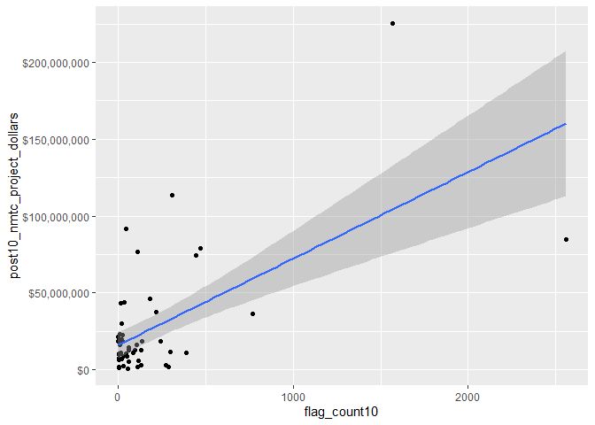
Here we can also see several outliers that are skewing the medians of our data.
Correlation between flag count and NMTC dollars spent within counties
# Pearson's r calculation
cor(svi_divisional_county_nmtc_projects$flag_count10, svi_divisional_county_nmtc_projects$post10_nmtc_project_dollars, method = "pearson")
## [1] 0.6174326
A Pearson’s R calculation of 0.62 suggests that there is a strong positive association between the dollar amount spent in NMTC from 2011-2020 and the flag count within the Mountain Division counties in 2010.
Let’s look at a box plot to examine this further:
boxplot(svi_divisional_county_nmtc_projects$flag_count10)
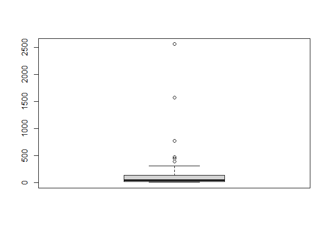
boxplot.stats(svi_divisional_county_nmtc_projects$flag_count10)$out %>% sort(decreasing = TRUE)
## [1] 2558 1569 771 473 444 390
The boxplot shows most of our data lies within the lower quadrant of flag counts. Additionally, there are 6 outliers identified. There are identified here:
svi_divisional_county_nmtc_projects %>%
  select(county_name, flag_count10, post10_nmtc_dollars_formatted) %>%
  arrange(desc(flag_count10)) %>%
  head(6) %>% kbl() %>% kable_styling() %>% scroll_box(width = "100%")
| county_name | flag_count10 | post10_nmtc_dollars_formatted |
|---|---|---|
| Maricopa County, AZ | 2558 | \$84,923,464 |
| Clark County, NV | 1569 | \$225,315,967 |
| Pima County, AZ | 771 | \$36,122,128 |
| Denver County, CO | 473 | \$78,905,000 |
| Bernalillo County, NM | 444 | \$74,237,755 |
| Adams County, CO | 390 | \$11,168,200 |
Let’s examine our major outlier, Maricopa County, AZ data point further:
svi_divisional_nmtc %>% filter(county == "Maricopa County") %>% select(GEOID_2010_trt, F_TOTAL_10, post10_nmtc_dollars) %>% summary()
##  GEOID_2010_trt       F_TOTAL_10     post10_nmtc_dollars
##  Length:322         Min.   : 1.000   Min.   :       0
##  Class :character   1st Qu.: 5.000   1st Qu.:       0
##  Mode  :character   Median : 9.000   Median :       0
##                     Mean   : 7.944   Mean   :  263737
##                     3rd Qu.:11.000   3rd Qu.:       0
##                     Max.   :14.000   Max.   :22900000
There are 322 tracts in Maricopa County, with a median divisional flag count of 9 flags, so it makes sense for Maricopa County to have 2558 flags. This is lower than the average 47 flags in the Mountain Division. Interestingly, Maricopa County, while having the highest number of flag counts in the Mountain Division, has not received the highest amount of NMTC dollars.
K-Means Clustering
svi_divisional_nmtc_cluster <- svi_divisional_county_nmtc_projects %>%
                            select(county_name, post10_nmtc_project_dollars,
                                   flag_count10) %>%
                            remove_rownames %>%
                            column_to_rownames(var="county_name")

# Remove nulls, if in dataset
svi_divisional_nmtc_cluster <- na.omit(svi_divisional_nmtc_cluster)


# Scale numeric variables
svi_divisional_nmtc_cluster <- scale(svi_divisional_nmtc_cluster)


svi_divisional_nmtc_cluster %>% head(5)
##                     post10_nmtc_project_dollars flag_count10
## Apache County, AZ                    -0.3541120   -0.1073628
## Gila County, AZ                      -0.5466172   -0.2773136
## Maricopa County, AZ                   1.5935295    5.8655464
## Navajo County, AZ                     0.5497734    0.0182530
## Pima County, AZ                       0.2803462    1.4640665
set.seed(123)
k2_nmtc_div <- kmeans(svi_divisional_nmtc_cluster, centers = 2, nstart = 25)
set.seed(123)
k3_nmtc_div <- kmeans(svi_divisional_nmtc_cluster, centers = 3, nstart = 25)
set.seed(123)
k4_nmtc_div <- kmeans(svi_divisional_nmtc_cluster, centers = 4, nstart = 25)
set.seed(123)
k5_nmtc_div <- kmeans(svi_divisional_nmtc_cluster, centers = 5, nstart = 25)
# plots to compare
p_k2_nmtc_div <- factoextra::fviz_cluster(k2_nmtc_div, geom = "point", data = svi_divisional_nmtc_cluster) + ggtitle("k = 2")

p_k3_nmtc_div <- factoextra::fviz_cluster(k3_nmtc_div, geom = "point", data = svi_divisional_nmtc_cluster) + ggtitle("k = 3")

p_k4_nmtc_div <- factoextra::fviz_cluster(k4_nmtc_div, geom = "point",  data = svi_divisional_nmtc_cluster) + ggtitle("k = 4")

p_k5_nmtc_div <- factoextra::fviz_cluster(k5_nmtc_div, geom = "point",  data = svi_divisional_nmtc_cluster) + ggtitle("k = 5")

grid.arrange(p_k2_nmtc_div, p_k3_nmtc_div, p_k4_nmtc_div, p_k5_nmtc_div, nrow = 2)
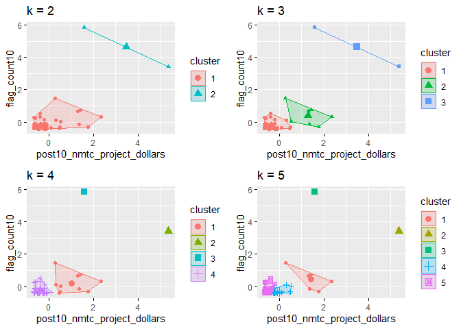
In visually inspecting our plots, it appears that k=3 has the best grouping to the eye, with no overlap in the groups.
elbow_plot(svi_divisional_nmtc_cluster)
##  [1]  1  2  3  4  5  6  7  8  9 10 11 12 13 14 15
## [1] 1
## [1] 2
## [1] 3
## [1] 4
## [1] 5
## [1] 6
## [1] 7
## [1] 8
## [1] 9
## [1] 10
## [1] 11
## [1] 12
## [1] 13
## [1] 14
## [1] 15
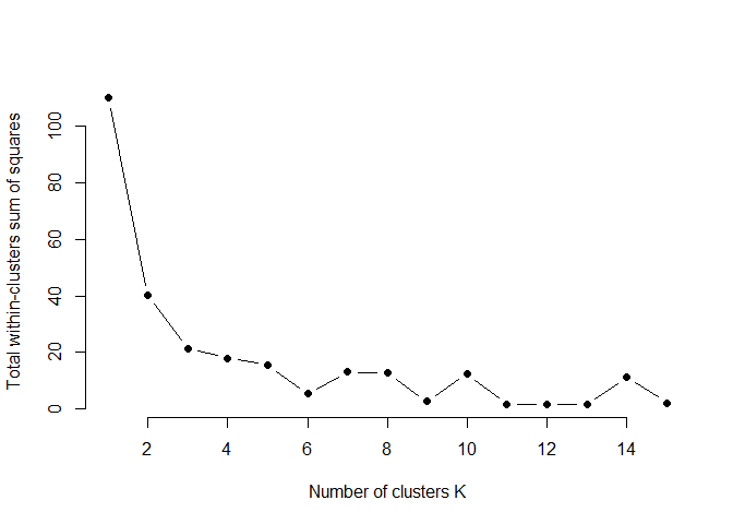
In looking at our elbow plot, it appears that there is not much variation between point 3 and 4. This aligns well with our visual observation.
p_k3_nmtc_div <- factoextra::fviz_cluster(k3_nmtc_div, geom = "point", data = svi_divisional_nmtc_cluster) + ggtitle("k = 3")

p_k3_nmtc_div
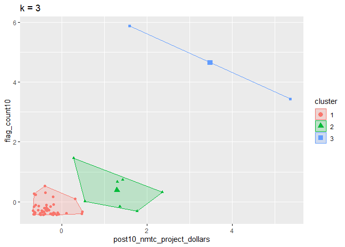
Here we will assign these 3 clusters to our county data set:
svi_divisional_nmtc_cluster_label <- as.data.frame(svi_divisional_nmtc_cluster) %>%
                                  rownames_to_column(var = "county_name") %>%
                                  as_tibble() %>%
                                  mutate(cluster = k3_nmtc_div$cluster) %>%
                                  select(county_name, cluster)

svi_divisional_county_nmtc_projects2 <- left_join(svi_divisional_county_nmtc_projects, svi_divisional_nmtc_cluster_label, join_by(county_name == county_name))

# View county counts in each cluster
table(svi_divisional_county_nmtc_projects2$cluster)
##
##  1  2  3
## 47  7  2
Cluster 1
# Cluster 1 Scatterplot
# y is our independent variable (NMTC Project Dollars),
# x is our dependent variable (SVI flag count)

svi_divisional_county_nmtc_projects2 %>%
  filter(cluster == 1) %>%
  ggplot2::ggplot(aes(x=flag_count10,
                    y=post10_nmtc_project_dollars)) +
        geom_point() +
        geom_smooth(method="lm") +
        scale_y_continuous(labels = scales::dollar_format())
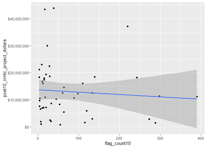
svi_divisional_county_nmtc_projects2 %>%
  filter(cluster == 1) %>%
  select(flag_count10,post10_nmtc_project_dollars) %>%
  cor(method = "pearson")
##                             flag_count10 post10_nmtc_project_dollars
## flag_count10                  1.00000000                 -0.07984396
## post10_nmtc_project_dollars  -0.07984396                  1.00000000
This cluster contains the majority of our counties that received NMTC funding and shows a very weak negative, or no association correlation between flag counts from 2010 census data and money received the following decade from NMTC.
Here are the counties that fall into cluster 1:
svi_divisional_county_nmtc_projects2 %>%
  filter(cluster == 1) %>%
  select(county_name, flag_count10, post10_nmtc_dollars_formatted) %>% kbl() %>% kable_styling() %>% scroll_box(width = "100%")
| county_name | flag_count10 | post10_nmtc_dollars_formatted |
|---|---|---|
| Apache County, AZ | 133 | \$12,544,000 |
| Gila County, AZ | 64 | \$5,390,000 |
| Pinal County, AZ | 220 | \$37,224,559 |
| Yuma County, AZ | 288 | \$1,454,000 |
| Adams County, CO | 390 | \$11,168,200 |
| Arapahoe County, CO | 298 | \$11,357,669 |
| Archuleta County, CO | 7 | \$1,950,000 |
| Boulder County, CO | 115 | \$1,500,000 |
| Delta County, CO | 8 | \$1,009,700 |
| Jefferson County, CO | 120 | \$5,880,000 |
| Larimer County, CO | 98 | \$12,340,000 |
| Mesa County, CO | 55 | \$800,000 |
| Washington County, CO | 4 | \$9,640,000 |
| Bannock County, ID | 28 | \$22,425,000 |
| Madison County, ID | 17 | \$43,440,000 |
| Valley County, ID | 3 | \$21,148,000 |
| Big Horn County, MT | 33 | \$8,624,000 |
| Cascade County, MT | 45 | \$10,189,000 |
| Chouteau County, MT | 4 | \$7,663,000 |
| Gallatin County, MT | 11 | \$6,960,000 |
| Glacier County, MT | 20 | \$7,129,500 |
| Hill County, MT | 13 | \$7,081,000 |
| Lake County, MT | 11 | \$16,715,500 |
| Lewis and Clark County, MT | 9 | \$23,069,500 |
| Missoula County, MT | 15 | \$17,945,000 |
| Roosevelt County, MT | 14 | \$7,104,000 |
| Silver Bow County, MT | 12 | \$16,056,000 |
| Yellowstone County, MT | 39 | \$43,880,900 |
| Chaves County, NM | 64 | \$14,550,000 |
| Dona Ana County, NM | 243 | \$18,187,500 |
| Eddy County, NM | 20 | \$19,400,000 |
| McKinley County, NM | 139 | \$18,460,000 |
| San Juan County, NM | 89 | \$10,690,000 |
| San Miguel County, NM | 53 | \$8,330,000 |
| Sandoval County, NM | 61 | \$12,480,000 |
| Santa Fe County, NM | 110 | \$16,045,000 |
| Douglas County, NV | 5 | \$10,500,000 |
| Elko County, NV | 23 | \$30,000,000 |
| Lyon County, NV | 30 | \$2,520,000 |
| Nye County, NV | 32 | \$2,000,000 |
| Washoe County, NV | 273 | \$2,810,000 |
| Grand County, UT | 3 | \$18,378,750 |
| Iron County, UT | 29 | \$18,625,000 |
| Utah County, UT | 133 | \$2,950,000 |
| Albany County, WY | 15 | \$17,460,000 |
| Fremont County, WY | 18 | \$10,874,750 |
| Goshen County, WY | 6 | \$6,556,800 |
Cluster 2
# Cluster 2 Scatterplot
# y is our independent variable (NMTC Project Dollars),
# x is our dependent variable (SVI flag count)

svi_divisional_county_nmtc_projects2 %>%
  filter(cluster == 2) %>%
  ggplot2::ggplot(aes(x=flag_count10,
                    y=post10_nmtc_project_dollars)) +
        geom_point() +
        geom_smooth(method="lm") +
        scale_y_continuous(labels = scales::dollar_format())
## `geom_smooth()` using formula = 'y ~ x'
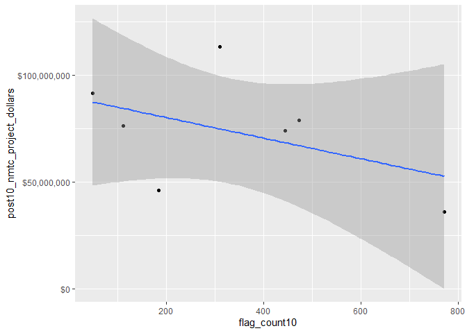
Cluster 2
svi_divisional_county_nmtc_projects2 %>%
  filter(cluster == 2) %>%
  select(flag_count10,post10_nmtc_project_dollars) %>%
  cor(method = "pearson")
##                             flag_count10 post10_nmtc_project_dollars
## flag_count10                    1.000000                   -0.462471
## post10_nmtc_project_dollars    -0.462471                    1.000000
This cluster group contained only 7 data points, and shows a moderate negative correlation (Pearson’s R of -0.46) between flag count in 2010 and NMTC money received the following decade.
These are our Cluster 2 counties:
svi_divisional_county_nmtc_projects2 %>%
  filter(cluster == 2) %>%
  select(county_name, flag_count10, post10_nmtc_dollars_formatted)
##             county_name flag_count10 post10_nmtc_dollars_formatted
## 1     Navajo County, AZ          184                   $46,134,750
## 2       Pima County, AZ          771                   $36,122,128
## 3     Denver County, CO          473                   $78,905,000
## 4     Canyon County, ID          111                   $76,432,000
## 5 Bernalillo County, NM          444                   $74,237,755
## 6     Cibola County, NM           49                   $91,548,630
## 7  Salt Lake County, UT          310                  $113,282,833
Cluster 3
# Cluster 3 Scatterplot
# y is our independent variable (NMTC Project Dollars),
# x is our dependent variable (SVI flag count)

svi_divisional_county_nmtc_projects2 %>%
  filter(cluster == 3) %>%
  ggplot2::ggplot(aes(x=flag_count10,
                    y=post10_nmtc_project_dollars)) +
        geom_point() +
        geom_smooth(method="lm") +
        scale_y_continuous(labels = scales::dollar_format())
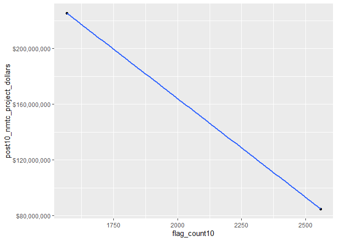
svi_divisional_county_nmtc_projects2 %>%
  filter(cluster == 3) %>%
  select(flag_count10,post10_nmtc_project_dollars) %>%
  cor(method = "pearson")
##                             flag_count10 post10_nmtc_project_dollars
## flag_count10                           1                          -1
## post10_nmtc_project_dollars           -1                           1
In looking at our correlation for cluster 3 which contain our outliers, a Pearson’s R score of -1 shows a high negative correlation within our cluster between flag count and money received in these 2 counties. However, we know that there are only 2 data points in this cluster.
These are the 2 counties in Cluster 3:
svi_divisional_county_nmtc_projects2 %>%
  filter(cluster == 3) %>%
  select(county_name, flag_count10, post10_nmtc_dollars_formatted)
##           county_name flag_count10 post10_nmtc_dollars_formatted
## 1 Maricopa County, AZ         2558                   $84,923,464
## 2    Clark County, NV         1569                  $225,315,967
Overall, if we look at cluster 1, we see that it contains the majority of our data. It also shows that for the majority of our data points, there is almost no correlation between the amount of money received in NMTC and the SVI vulnerability flag count.
Bivariate Mapping
divisional_county_sf <- svi_county_map2010 %>% select(COUNTYFP, STATEFP, geometry)

divisional_county_sf %>% head(5)
## Simple feature collection with 5 features and 2 fields
## Geometry type: MULTIPOLYGON
## Dimension:     XY
## Bounding box:  xmin: -113.3542 ymin: 31.3325 xmax: -109.0452 ymax: 37.0032
## Geodetic CRS:  NAD83
##   COUNTYFP STATEFP                       geometry
## 1      001      04 MULTIPOLYGON (((-109.0464 3...
## 2      003      04 MULTIPOLYGON (((-110.0031 3...
## 3      005      04 MULTIPOLYGON (((-112.3754 3...
## 4      007      04 MULTIPOLYGON (((-111.2865 3...
## 5      009      04 MULTIPOLYGON (((-110.4486 3...
# Join our NMTC projects data with our shapefile geocoordinates
svi_divisional_county_nmtc_sf <- left_join(svi_divisional_county_nmtc_projects, divisional_county_sf, join_by("FIPS_st" == "STATEFP", "FIPS_county" == "COUNTYFP"))

svi_divisional_county_nmtc_sf %>% head(5) %>% kbl() %>% kable_styling() %>% scroll_box(width = "100%")
| State | County | Division | post10_nmtc_project_cnt | tract_cnt | post10_nmtc_project_dollars | post10_nmtc_dollars_formatted | fips_county_st | FIPS_st | FIPS_county | state_name | region_number | region | division_number | flag_count10 | pop10 | flag_by_pop10 | flag_count_quantile10 | flag_pop_quantile10 | flag_count20 | pop20 | flag_by_pop20 | flag_count_quantile20 | flag_pop_quantile20 | county_name | geometry |
|---|---|---|---|---|---|---|---|---|---|---|---|---|---|---|---|---|---|---|---|---|---|---|---|---|---|
| AZ | Apache County | Mountain Division | 1 | 14 | 12544000 | \$12,544,000 | 04001 | 04 | 001 | Arizona | 4 | West Region | 8 | 133 | 62408 | 0.0021311 | 1 | 0.8 | 124 | 62852 | 0.0019729 | 1 | 0.8 | Apache County, AZ | MULTIPOLYGON (((-109.0464 3… |
| AZ | Gila County | Mountain Division | 1 | 11 | 5390000 | \$5,390,000 | 04007 | 04 | 007 | Arizona | 4 | West Region | 8 | 64 | 31239 | 0.0020487 | 1 | 0.8 | 72 | 31645 | 0.0022752 | 1 | 1.0 | Gila County, AZ | MULTIPOLYGON (((-111.2865 3… |
| AZ | Maricopa County | Mountain Division | 15 | 322 | 84923464 | \$84,923,464 | 04013 | 04 | 013 | Arizona | 4 | West Region | 8 | 2558 | 1355508 | 0.0018871 | 1 | 0.8 | 2457 | 1547710 | 0.0015875 | 1 | 0.6 | Maricopa County, AZ | MULTIPOLYGON (((-112.9158 3… |
| AZ | Navajo County | Mountain Division | 2 | 24 | 46134750 | \$46,134,750 | 04017 | 04 | 017 | Arizona | 4 | West Region | 8 | 184 | 83885 | 0.0021935 | 1 | 1.0 | 200 | 87599 | 0.0022831 | 1 | 1.0 | Navajo County, AZ | MULTIPOLYGON (((-110.7021 3… |
| AZ | Pima County | Mountain Division | 7 | 104 | 36122128 | \$36,122,128 | 04019 | 04 | 019 | Arizona | 4 | West Region | 8 | 771 | 433051 | 0.0017804 | 1 | 0.8 | 826 | 439374 | 0.0018799 | 1 | 0.8 | Pima County, AZ | MULTIPOLYGON (((-112.3881 3… |
# Create classes for bivariate mapping
svi_divisional_county_nmtc_sf <- bi_class(svi_divisional_county_nmtc_sf, x = flag_count10, y = post10_nmtc_project_dollars, style = "quantile", dim = 3)

# View data
svi_divisional_county_nmtc_sf %>% head(5) %>% kbl() %>% kable_styling() %>% scroll_box(width = "100%")
| State | County | Division | post10_nmtc_project_cnt | tract_cnt | post10_nmtc_project_dollars | post10_nmtc_dollars_formatted | fips_county_st | FIPS_st | FIPS_county | state_name | region_number | region | division_number | flag_count10 | pop10 | flag_by_pop10 | flag_count_quantile10 | flag_pop_quantile10 | flag_count20 | pop20 | flag_by_pop20 | flag_count_quantile20 | flag_pop_quantile20 | county_name | geometry | bi_class |
|---|---|---|---|---|---|---|---|---|---|---|---|---|---|---|---|---|---|---|---|---|---|---|---|---|---|---|
| AZ | Apache County | Mountain Division | 1 | 14 | 12544000 | \$12,544,000 | 04001 | 04 | 001 | Arizona | 4 | West Region | 8 | 133 | 62408 | 0.0021311 | 1 | 0.8 | 124 | 62852 | 0.0019729 | 1 | 0.8 | Apache County, AZ | MULTIPOLYGON (((-109.0464 3… | 3-2 |
| AZ | Gila County | Mountain Division | 1 | 11 | 5390000 | \$5,390,000 | 04007 | 04 | 007 | Arizona | 4 | West Region | 8 | 64 | 31239 | 0.0020487 | 1 | 0.8 | 72 | 31645 | 0.0022752 | 1 | 1.0 | Gila County, AZ | MULTIPOLYGON (((-111.2865 3… | 2-1 |
| AZ | Maricopa County | Mountain Division | 15 | 322 | 84923464 | \$84,923,464 | 04013 | 04 | 013 | Arizona | 4 | West Region | 8 | 2558 | 1355508 | 0.0018871 | 1 | 0.8 | 2457 | 1547710 | 0.0015875 | 1 | 0.6 | Maricopa County, AZ | MULTIPOLYGON (((-112.9158 3… | 3-3 |
| AZ | Navajo County | Mountain Division | 2 | 24 | 46134750 | \$46,134,750 | 04017 | 04 | 017 | Arizona | 4 | West Region | 8 | 184 | 83885 | 0.0021935 | 1 | 1.0 | 200 | 87599 | 0.0022831 | 1 | 1.0 | Navajo County, AZ | MULTIPOLYGON (((-110.7021 3… | 3-3 |
| AZ | Pima County | Mountain Division | 7 | 104 | 36122128 | \$36,122,128 | 04019 | 04 | 019 | Arizona | 4 | West Region | 8 | 771 | 433051 | 0.0017804 | 1 | 0.8 | 826 | 439374 | 0.0018799 | 1 | 0.8 | Pima County, AZ | MULTIPOLYGON (((-112.3881 3… | 3-3 |
# Create map with ggplot
svi_divisional_county_nmtc_map <- ggplot() +
  # Map county shapefile, fill with bi_class categories
  geom_sf(data = svi_divisional_county_nmtc_sf, mapping = aes(geometry=geometry, fill = bi_class), color = "white", size = 0.1, show.legend = FALSE) +
  # Set to biscale palette
  bi_scale_fill(pal = "GrPink", dim = 3) +
  # Add state shapefiles for outline
  geom_sf(data=divisional_st_sf, color="black", fill=NA, linewidth=.5, aes(geometry=geometry)) +
  labs(
    title = paste0("Correlation of 2010 ", census_division, " SVI Flag Count \n and 2011 - 2020 NMTC Tax Dollars"),
  ) +
  # Set them to biscale
  bi_theme(base_size = 10)

# Create biscale legend
svi_divisional_county_nmtc_legend <- bi_legend(pal = "GrPink",
                    dim = 3,
                    xlab = "SVI Flag Count",
                    ylab = "NMTC Dollars",
                    size = 8)

# Combine map with legend using cowplot
svi_divisional_county_nmtc_bivarmap <- ggdraw() +
  draw_plot(svi_divisional_county_nmtc_map) +
  # Set legend location
  draw_plot(svi_divisional_county_nmtc_legend, x= -.02,  y = -.05,
 width=.20)


# View map
svi_divisional_county_nmtc_bivarmap
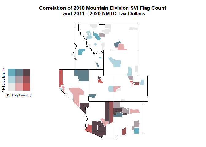
Here we can see the distribution of SVI flag counts and NMTC dollars spent in each county receiving funds. Montana, Idaho, and Wyoming received high dollars compared to low flag counts, indicated by the blue color.
svi_divisional_county_nmtc_sf %>% filter(State %in% c("MT", "ID", "WY")) %>%
  arrange(desc(post10_nmtc_project_dollars), flag_count10) %>% select(State, County, flag_count10, post10_nmtc_dollars_formatted) %>% head(10)
##    State                 County flag_count10 post10_nmtc_dollars_formatted
## 1     ID          Canyon County          111                   $76,432,000
## 2     MT     Yellowstone County           39                   $43,880,900
## 3     ID         Madison County           17                   $43,440,000
## 4     MT Lewis and Clark County            9                   $23,069,500
## 5     ID         Bannock County           28                   $22,425,000
## 6     ID          Valley County            3                   $21,148,000
## 7     MT        Missoula County           15                   $17,945,000
## 8     WY          Albany County           15                   $17,460,000
## 9     MT            Lake County           11                   $16,715,500
## 10    MT      Silver Bow County           12                   $16,056,000
Nevada received the most dollars in the highest need counties, indicated by the purple dark purple color.
svi_divisional_county_nmtc_sf %>% filter(State %in% c("NV", "NM")) %>% select(State, County, flag_count10, post10_nmtc_dollars_formatted) %>% arrange(desc(flag_count10)) %>% head(10)
##    State            County flag_count10 post10_nmtc_dollars_formatted
## 1     NV      Clark County         1569                  $225,315,967
## 2     NM Bernalillo County          444                   $74,237,755
## 3     NV     Washoe County          273                    $2,810,000
## 4     NM   Dona Ana County          243                   $18,187,500
## 5     NM   McKinley County          139                   $18,460,000
## 6     NM   Santa Fe County          110                   $16,045,000
## 7     NM   San Juan County           89                   $10,690,000
## 8     NM     Chaves County           64                   $14,550,000
## 9     NM   Sandoval County           61                   $12,480,000
## 10    NM San Miguel County           53                    $8,330,000
2010 Low Income Housing Tax Credit Mountain Division
svi_divisional_county_lihtc_projects <- svi_divisional_county_lihtc %>% filter(post10_lihtc_project_cnt > 0)

svi_divisional_county_lihtc_projects %>% select(Division) %>% unique()
##            Division
## 1 Mountain Division
Data Summary Statistics
summary(svi_divisional_county_lihtc_projects$flag_count10)
##    Min. 1st Qu.  Median    Mean 3rd Qu.    Max.
##    9.00   15.50   21.00   67.33   56.50  487.00
summary(svi_divisional_county_lihtc_projects$post10_lihtc_project_dollars)
##     Min.  1st Qu.   Median     Mean  3rd Qu.     Max.
##        0   674696  1721391  3350971  3203130 15437500
Filter out counties with LIHTC projects but did not receive any funding:
svi_divisional_county_lihtc_projects <- svi_divisional_county_lihtc_projects %>% filter(post10_lihtc_project_dollars > 0)
summary(svi_divisional_county_lihtc_projects$flag_count10)
##    Min. 1st Qu.  Median    Mean 3rd Qu.    Max.
##    9.00   14.75   21.00   64.64   33.75  487.00
summary(svi_divisional_county_lihtc_projects$post10_lihtc_project_dollars)
##     Min.  1st Qu.   Median     Mean  3rd Qu.     Max.
##   270127   817782  1836756  3590326  3380196 15437500
The Mountain division counties receiving LIHTC project funding between 2011-2020, had a range of 9 to 487 SVI flags in 2010. The funding amounts ranged from $270,127 and $15,437,500. There is a large range between counties in the number of SVI flags in 2010 and funding dollars spent between 2011 and 2020.
Let’s view this data visually in a scatterplot:
# Scatterplot
# y is our independent variable (LIHTC Project Dollars),
# x is our dependent variable (SVI flag count)
ggplot2::ggplot(svi_divisional_county_lihtc_projects,
                aes(x=flag_count10,
                    y=post10_lihtc_project_dollars)) +
        geom_point() +
        geom_smooth(method="lm") +
        scale_y_continuous(labels = scales::dollar_format())
## `geom_smooth()` using formula = 'y ~ x'

Here we can see 1 outlier in dollars spent.
Pearson’s R Correlation between SVI flag count and LIHTC dollars spent
# Pearson's r calculation
cor(svi_divisional_county_lihtc_projects$flag_count10, svi_divisional_county_lihtc_projects$post10_lihtc_project_dollars, method = "pearson")
## [1] 0.5743274
Overall, within all the counties in the Mountain Division, there is a moderate positive correlation between SVI flags from 2010 and dollars spent on LIHTC in 2011-2020, with a Pearson’s score of 0.57.
Here is a boxplot of this data:
boxplot(svi_divisional_county_lihtc_projects$flag_count10)
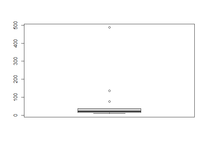
Here we can see three outliers, with high flag counts:
boxplot.stats(svi_divisional_county_lihtc_projects$flag_count10)$out %>% sort(decreasing = TRUE)
## [1] 487 136 76
svi_divisional_county_lihtc_projects %>% filter(flag_count10 == 487) %>% select(county_name, flag_count10, post10_lihtc_dollars_formatted) %>% head()
##           county_name flag_count10 post10_lihtc_dollars_formatted
## 1 Maricopa County, AZ          487                    $13,115,292
Again, we can see that Maricopa County is also an outlier in flag counts.
K-Means Clustering
svi_divisional_lihtc_cluster <- svi_divisional_county_lihtc_projects %>%
                            select(county_name, post10_lihtc_project_dollars,
                                   flag_count10) %>%
                            remove_rownames %>%
                            column_to_rownames(var="county_name")

# Remove nulls, if in dataset
svi_divisional_lihtc_cluster <- na.omit(svi_divisional_lihtc_cluster)


# Scale numeric variables
svi_divisional_lihtc_cluster <- scale(svi_divisional_lihtc_cluster)


svi_divisional_lihtc_cluster %>% head(5)
##                     post10_lihtc_project_dollars flag_count10
## Gila County, AZ                     -0.639463325  -0.34550646
## Maricopa County, AZ                  2.001527998   3.34366562
## Pima County, AZ                     -0.006948156   0.56491154
## Yuma County, AZ                     -0.572769441  -0.34550646
## Denver County, CO                    0.343739090   0.08991085
Let’s look at different cluster groupings:
set.seed(123)
k2_lihtc_div <- kmeans(svi_divisional_lihtc_cluster, centers = 2, nstart = 25)
set.seed(123)
k3_lihtc_div <- kmeans(svi_divisional_lihtc_cluster, centers = 3, nstart = 25)
set.seed(123)
k4_lihtc_div <- kmeans(svi_divisional_lihtc_cluster, centers = 4, nstart = 25)
set.seed(123)
k5_lihtc_div <- kmeans(svi_divisional_lihtc_cluster, centers = 5, nstart = 25)


# plots to compare
p_k2_lihtc_div <- factoextra::fviz_cluster(k2_lihtc_div, geom = "point", data = svi_divisional_lihtc_cluster) + ggtitle("k = 2")

p_k3_lihtc_div <- factoextra::fviz_cluster(k3_lihtc_div, geom = "point", data = svi_divisional_lihtc_cluster) + ggtitle("k = 3")

p_k4_lihtc_div <- factoextra::fviz_cluster(k4_lihtc_div, geom = "point",  data = svi_divisional_lihtc_cluster) + ggtitle("k = 4")

p_k5_lihtc_div <- factoextra::fviz_cluster(k5_lihtc_div, geom = "point",  data = svi_divisional_lihtc_cluster) + ggtitle("k = 5")

grid.arrange(p_k2_lihtc_div, p_k3_lihtc_div, p_k4_lihtc_div, p_k5_lihtc_div, nrow = 2)
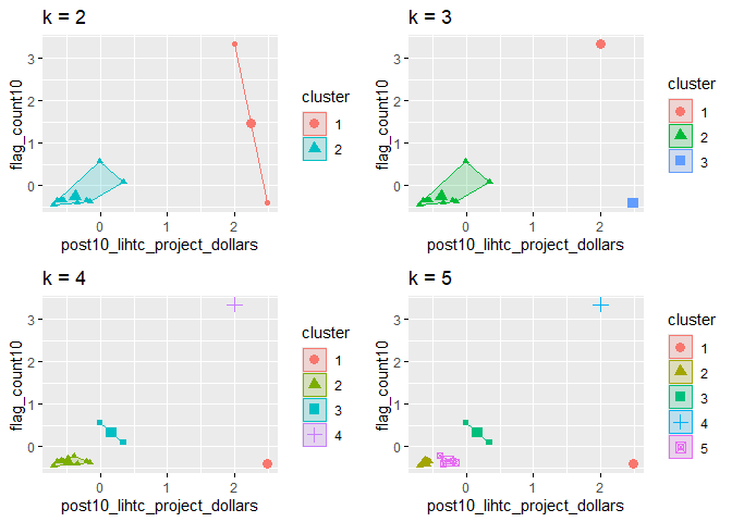
Visually, 2 clusters looks to capture our data points best, but we can check an elbow plot:
elbow_plot(svi_divisional_lihtc_cluster)
##  [1]  1  2  3  4  5  6  7  8  9 10 11 12 13
## [1] 1
## [1] 2
## [1] 3
## [1] 4
## [1] 5
## [1] 6
## [1] 7
## [1] 8
## [1] 9
## [1] 10
## [1] 11
## [1] 12
## [1] 13
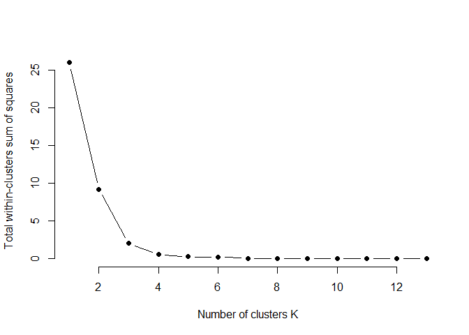
This elbow plot shows that 3 clusters makes sense, as the spacing does not decrease until after point 3. I will choose to use three clusters for the LIHTC data for the Mountain Division:
p_k3_lihtc_div <- factoextra::fviz_cluster(k3_lihtc_div, geom = "point", data = svi_divisional_lihtc_cluster) + ggtitle("k = 3")

p_k3_lihtc_div
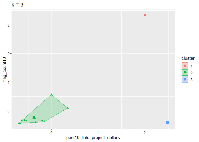
Let’s assign these clusters to our county data:
svi_divisional_lihtc_cluster_label <- as.data.frame(svi_divisional_lihtc_cluster) %>%
                                  rownames_to_column(var = "county_name") %>%
                                  as_tibble() %>%
                                  mutate(cluster = k3_lihtc_div$cluster) %>%
                                  select(county_name, cluster)

svi_divisional_county_lihtc_projects2 <- left_join(svi_divisional_county_lihtc_projects, svi_divisional_lihtc_cluster_label, join_by(county_name == county_name))

# View county counts in each cluster
table(svi_divisional_county_lihtc_projects2$cluster)
##
##  1  2  3
##  1 12  1
Again this was our scatterplot and Pearson’s R for the overall data:
# Overall Scatterplot
# y is our independent variable (LIHTC Project Dollars),
# x is our dependent variable (SVI flag count)
ggplot2::ggplot(svi_divisional_county_lihtc_projects2,
                aes(x=flag_count10,
                    y=post10_lihtc_project_dollars)) +
        geom_point() +
        geom_smooth(method="lm") +
        scale_y_continuous(labels = scales::dollar_format())
## `geom_smooth()` using formula = 'y ~ x'
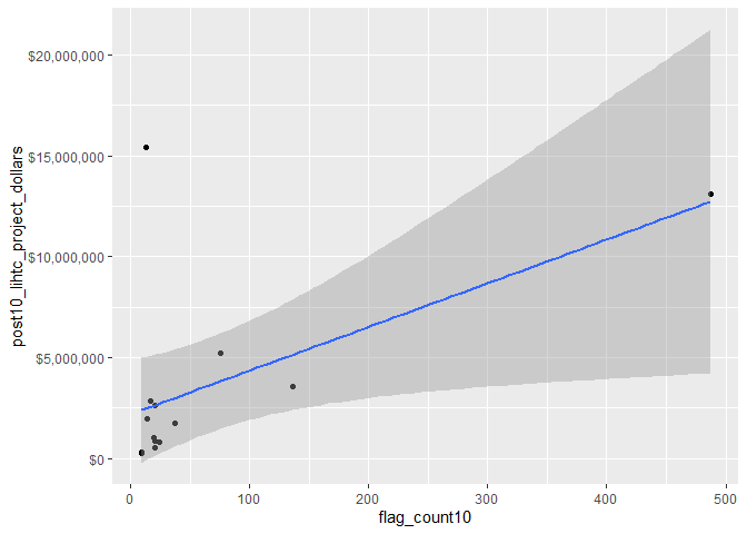
# Pearson's r calculation
cor(svi_divisional_county_lihtc_projects2$flag_count10, svi_divisional_county_lihtc_projects2$post10_lihtc_project_dollars, method = "pearson")
## [1] 0.5743274
Cluster 1
# Cluster 1 Scatterplot
# y is our independent variable (LIHTC Project Dollars),
# x is our dependent variable (SVI flag count)

svi_divisional_county_lihtc_projects2 %>%
  filter(cluster == 1) %>%
  ggplot2::ggplot(aes(x=flag_count10,
                    y=post10_lihtc_project_dollars)) +
        geom_point() +
        geom_smooth(method="lm") +
        scale_y_continuous(labels = scales::dollar_format())
We only have 1 data point in cluster 1, so we cannot calculate correlation. Here is our county information:
svi_divisional_county_lihtc_projects2 %>%
  filter(cluster == 1) %>%
  select(county_name, flag_count10, post10_lihtc_dollars_formatted) %>%
  arrange(desc(flag_count10)) %>% head(10)
##           county_name flag_count10 post10_lihtc_dollars_formatted
## 1 Maricopa County, AZ          487                    $13,115,292
Again, Maricopa County stands out as an outlier.
Cluster 2
# Cluster 2 Scatterplot
# y is our independent variable (LIHTC Project Dollars),
# x is our dependent variable (SVI flag count)

svi_divisional_county_lihtc_projects2 %>%
  filter(cluster == 2) %>%
  ggplot2::ggplot(aes(x=flag_count10,
                    y=post10_lihtc_project_dollars)) +
        geom_point() +
        geom_smooth(method="lm") +
        scale_y_continuous(labels = scales::dollar_format())
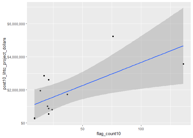
svi_divisional_county_lihtc_projects2 %>%
  filter(cluster == 2) %>%
  select(flag_count10,post10_lihtc_project_dollars) %>%
  cor(method = "pearson")
##                              flag_count10 post10_lihtc_project_dollars
## flag_count10                    1.0000000                    0.6788349
## post10_lihtc_project_dollars    0.6788349                    1.0000000
Cluster 2 contains all but 2 of our data points. With a Pearson’s R of 0.68, there is a strong correlation between LIHTC dollars and SVI need.
Here are the 12 counties in this cluster:
svi_divisional_county_lihtc_projects2 %>%
  filter(cluster == 2) %>%
  select(county_name, flag_count10, post10_lihtc_dollars_formatted) %>%
  arrange(desc(flag_count10)) %>% head(12)
##             county_name flag_count10 post10_lihtc_dollars_formatted
## 1       Pima County, AZ          136                     $3,557,261
## 2     Denver County, CO           76                     $5,226,128
## 3       Utah County, UT           37                     $1,721,391
## 4   San Juan County, NM           24                       $802,175
## 5       Gila County, AZ           21                       $547,218
## 6       Yuma County, AZ           21                       $864,604
## 7    Larimer County, CO           21                     $2,609,648
## 8    El Paso County, CO           20                     $1,011,891
## 9   Big Horn County, MT           17                     $2,849,000
## 10 Salt Lake County, UT           14                     $1,952,122
## 11    Canyon County, ID            9                       $300,210
## 12   Fremont County, WY            9                       $270,127
Cluster 3
# Cluster 3 Scatterplot
# y is our independent variable (LIHTC Project Dollars),
# x is our dependent variable (SVI flag count)

svi_divisional_county_lihtc_projects2 %>%
  filter(cluster == 3) %>%
  ggplot2::ggplot(aes(x=flag_count10,
                    y=post10_lihtc_project_dollars)) +
        geom_point() +
        geom_smooth(method="lm") +
        scale_y_continuous(labels = scales::dollar_format())
Cluster 3 only contains 1 data point so there is no correlation information for this cluster. Here is the county information for this cluster:
svi_divisional_county_lihtc_projects2 %>%
  filter(cluster == 3) %>%
  select(county_name, flag_count10, post10_lihtc_dollars_formatted) %>%
  arrange(desc(flag_count10)) %>% head(10)
##       county_name flag_count10 post10_lihtc_dollars_formatted
## 1 Mesa County, CO           13                    $15,437,500
**In summary, after clustering, we pulled out 1 county outlier with a high flag count (Maricopa County, AZ) and 1 county outlier with a high dollar amount (Mesa County, CO), and our correlation between LIHTC funding received in 2011-2020 is strongly correlated with the SVI vulnerability flag count in 2010.
Bivariate Mapping
# Join our LIHTC projects data with our shapefile geocoordinates
svi_divisional_county_lihtc_sf <- left_join(svi_divisional_county_lihtc_projects, divisional_county_sf, join_by("FIPS_st" == "STATEFP", "FIPS_county" == "COUNTYFP"))

svi_divisional_county_lihtc_sf %>% head(5)
##   State          County          Division post10_lihtc_project_cnt tract_cnt
## 1    AZ     Gila County Mountain Division                        1         2
## 2    AZ Maricopa County Mountain Division                       14        48
## 3    AZ     Pima County Mountain Division                        4        17
## 4    AZ     Yuma County Mountain Division                        1         2
## 5    CO   Denver County Mountain Division                        6         8
##   post10_lihtc_project_dollars post10_lihtc_dollars_formatted fips_county_st
## 1                       547218                       $547,218          04007
## 2                     13115292                    $13,115,292          04013
## 3                      3557261                     $3,557,261          04019
## 4                       864604                       $864,604          04027
## 5                      5226128                     $5,226,128          08031
##   FIPS_st FIPS_county state_name region_number      region division_number
## 1      04         007    Arizona             4 West Region               8
## 2      04         013    Arizona             4 West Region               8
## 3      04         019    Arizona             4 West Region               8
## 4      04         027    Arizona             4 West Region               8
## 5      08         031   Colorado             4 West Region               8
##   flag_count10  pop10 flag_by_pop10 flag_count_quantile10 flag_pop_quantile10
## 1           21   7245   0.002898551                   0.8                 0.8
## 2          487 168865   0.002883961                   1.0                 0.8
## 3          136  68218   0.001993609                   1.0                 0.4
## 4           21  10732   0.001956765                   0.8                 0.4
## 5           76  29499   0.002576359                   1.0                 0.6
##   flag_count20  pop20 flag_by_pop20 flag_count_quantile20 flag_pop_quantile20
## 1           18   8214   0.002191381                   0.8                 0.6
## 2          447 185321   0.002412031                   1.0                 0.6
## 3          158  73456   0.002150948                   1.0                 0.4
## 4           21  12232   0.001716808                   0.8                 0.4
## 5           41  33146   0.001236952                   1.0                 0.2
##           county_name                       geometry
## 1     Gila County, AZ MULTIPOLYGON (((-111.2865 3...
## 2 Maricopa County, AZ MULTIPOLYGON (((-112.9158 3...
## 3     Pima County, AZ MULTIPOLYGON (((-112.3881 3...
## 4     Yuma County, AZ MULTIPOLYGON (((-114.7546 3...
## 5   Denver County, CO MULTIPOLYGON (((-104.9341 3...
# Create classes for bivariate mapping
svi_divisional_county_lihtc_sf <- bi_class(svi_divisional_county_lihtc_sf, x = flag_count10, y = post10_lihtc_project_dollars, style = "quantile", dim = 3)

# View data
svi_divisional_county_lihtc_sf %>% head(5)
##   State          County          Division post10_lihtc_project_cnt tract_cnt
## 1    AZ     Gila County Mountain Division                        1         2
## 2    AZ Maricopa County Mountain Division                       14        48
## 3    AZ     Pima County Mountain Division                        4        17
## 4    AZ     Yuma County Mountain Division                        1         2
## 5    CO   Denver County Mountain Division                        6         8
##   post10_lihtc_project_dollars post10_lihtc_dollars_formatted fips_county_st
## 1                       547218                       $547,218          04007
## 2                     13115292                    $13,115,292          04013
## 3                      3557261                     $3,557,261          04019
## 4                       864604                       $864,604          04027
## 5                      5226128                     $5,226,128          08031
##   FIPS_st FIPS_county state_name region_number      region division_number
## 1      04         007    Arizona             4 West Region               8
## 2      04         013    Arizona             4 West Region               8
## 3      04         019    Arizona             4 West Region               8
## 4      04         027    Arizona             4 West Region               8
## 5      08         031   Colorado             4 West Region               8
##   flag_count10  pop10 flag_by_pop10 flag_count_quantile10 flag_pop_quantile10
## 1           21   7245   0.002898551                   0.8                 0.8
## 2          487 168865   0.002883961                   1.0                 0.8
## 3          136  68218   0.001993609                   1.0                 0.4
## 4           21  10732   0.001956765                   0.8                 0.4
## 5           76  29499   0.002576359                   1.0                 0.6
##   flag_count20  pop20 flag_by_pop20 flag_count_quantile20 flag_pop_quantile20
## 1           18   8214   0.002191381                   0.8                 0.6
## 2          447 185321   0.002412031                   1.0                 0.6
## 3          158  73456   0.002150948                   1.0                 0.4
## 4           21  12232   0.001716808                   0.8                 0.4
## 5           41  33146   0.001236952                   1.0                 0.2
##           county_name                       geometry bi_class
## 1     Gila County, AZ MULTIPOLYGON (((-111.2865 3...      2-1
## 2 Maricopa County, AZ MULTIPOLYGON (((-112.9158 3...      3-3
## 3     Pima County, AZ MULTIPOLYGON (((-112.3881 3...      3-3
## 4     Yuma County, AZ MULTIPOLYGON (((-114.7546 3...      2-1
## 5   Denver County, CO MULTIPOLYGON (((-104.9341 3...      3-3
# Create map with ggplot
svi_divisional_county_lihtc_map <- ggplot() +
  # Map county shapefile, fill with bi_class categories
  geom_sf(data = svi_divisional_county_lihtc_sf, mapping = aes(geometry=geometry, fill = bi_class), color = "white", size = 0.1, show.legend = FALSE) +
  # Set to biscale palette
  bi_scale_fill(pal = "GrPink", dim = 3) +
  # Add state shapefiles for outline
  geom_sf(data=divisional_st_sf, color="black", fill=NA, linewidth=.5, aes(geometry=geometry)) +
  labs(
    title = paste0("Correlation of 2010 ", census_division, " SVI Flag Count \n and 2011 - 2020 LIHTC Tax Dollars")
  ) +
  # Set them to biscale
  bi_theme(base_size = 10)

# Create biscale legend
svi_divisional_county_lihtc_legend <- bi_legend(pal = "GrPink",
                    dim = 3,
                    xlab = "SVI Flag Count",
                    ylab = "LIHTC Dollars",
                    size = 8)

# Combine map with legend using cowplot
svi_divisional_county_lihtc_bivarmap <- ggdraw() +
  draw_plot(svi_divisional_county_lihtc_map) +
  # Set legend location
  draw_plot(svi_divisional_county_lihtc_legend, x= -.02,  y = -.05,
 width=.20)


# View map
svi_divisional_county_lihtc_bivarmap
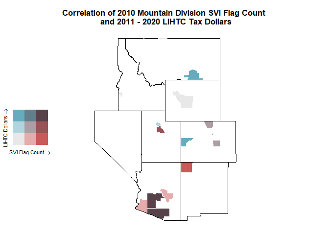
Here we can see that Idaho and Nevada did not receive any LIHTC project funding in 2011-2020. Again, Arizona has the counties with the highest need and the highest amount of LIHTC funding.
svi_divisional_county_lihtc_sf %>% filter(State == "AZ") %>% select(State, County, flag_count10, post10_lihtc_dollars_formatted) %>% arrange(desc(flag_count10)) %>% head()
##   State          County flag_count10 post10_lihtc_dollars_formatted
## 1    AZ Maricopa County          487                    $13,115,292
## 2    AZ     Pima County          136                     $3,557,261
## 3    AZ     Gila County           21                       $547,218
## 4    AZ     Yuma County           21                       $864,604
Again, Montana and Colorado received high funding dollars for a low amount of need:
svi_divisional_county_lihtc_sf %>% filter(State %in% c("MT", "CO")) %>%
  arrange(desc(post10_lihtc_project_dollars), flag_count10) %>% select(State, County, flag_count10, post10_lihtc_dollars_formatted) %>% head(10)
##   State          County flag_count10 post10_lihtc_dollars_formatted
## 1    CO     Mesa County           13                    $15,437,500
## 2    CO   Denver County           76                     $5,226,128
## 3    MT Big Horn County           17                     $2,849,000
## 4    CO  Larimer County           21                     $2,609,648
## 5    CO  El Paso County           20                     $1,011,891
#Save Data Sets

saveRDS(svi_divisional_lihtc, file = here::here(paste0("data/wrangling/", str_replace_all(census_division, " ", "_"), "_svi_divisional_lihtc.rds")))

saveRDS(svi_national_lihtc, file = here::here(paste0("data/wrangling/", str_replace_all(census_division, " ", "_"), "_svi_national_lihtc.rds")))

saveRDS(svi_divisional_nmtc, file = here::here(paste0("data/wrangling/", str_replace_all(census_division, " ", "_"), "_svi_divisional_nmtc.rds")))

saveRDS(svi_national_nmtc, file = here::here(paste0("data/wrangling/", str_replace_all(census_division, " ", "_"), "_svi_national_nmtc.rds")))
</div>